![]()
Prev Page--Description || Next Page--COELENTERATA, ANNELIDA, ECHINODERMATA
The Base and Summit of the Comanchean
In southern Kansas the Comanchean strata rest unconformably on the red beds of the Permian, the surface on which the strata were deposited having been developed by deep erosion. The relief does not appear to have been great, but it is probable that hills composed of Permian rock were not completely covered by the Comanchean strata (50, 53). The surface on which deposition occurred probably sloped to the south, and such a slope still obtains over the western extension, though now modified by a slope to the east. In the east part of the Comanchean area the base slopes to the s north and east.
In central Kansas the Comanchean rests on strata which in McPherson County are either Cimarron red beds or the Wellington shale. In the vicinity of Salina the underlying strata appear to belong to the Marion formation. The surface of the Permian here appears to have had considerable relief.
The upper surface of the Comanchean-"Dakota" in central Kansas is extremely irregular as a consequence of late Cretaceous or early Tertiary erosion. In places the "Dakota" has been completely taken away and the Tertiary rests on the Mentor beds. Elsewhere erosion has extended to the base of the Comanchean strata and the Tertiary rests on the Permian. Information in the possession of the writer does not permit a statement as to where the top of the strata described as Comanchean should be drawn.
Structure of the Marine Portions of the Comanchean Strata
Southern Kansas
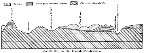
The geologic sections which follow, modified after Prosser, show the different structural relations of the Comanchean in southern Kansas. Throughout the western extension of the Comanchean strata in Clark County the elevation of the base varies from about 2,100 to 2,250 feet and the summit from 2,220 to 2,350 feet. In the eastern extensions around Belvidere the elevation of the base varies around 1,900 feet, thus indicating a dip to the east of 6 or 7 feet to a mile. From Avilla Hill to Belvidere the strata dip to the north, the base falling from about 1,950 feet at the former place to 1,850 or 1,900 feet at the latter. In the west Prosser gives a section extending from Mt. Jesus, about 4 miles north of Sitka, where the elevation of the base is about 2,100 feet, to the Clark-Ford county line, where the most northern exposure of the base has an elevation of 2,250 feet. It is known that there are local variations in inclination, but detail is wanting. One reversal of dip was noted by Prosser (50, p. 175) on the high prairie north of Ashland, making a small anticline with a broad base. (See plates III and IV.)
Plate III. Cross section from Sitka to the Ford County line, modified from Gould. A larger version of this figure is available.
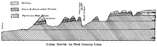
Plate IV. Cross section from Avilla Hill to northeast of Belvidere, modified after Gould. A larger version of this figure is available.
Central Kansas
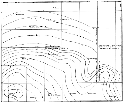
The structure of the marine portion of the Comanchean beds in central Kansas was determined by stadia and telescopic alidade survey. The actual work was done by Messrs. E. M. and M. L. Stryker, using the Mentor and the Windom members as key horizons. It is quite probable that some errors of detail occur in the results, but they can hardly be great. The results indicate that the strata are inclined to the north, east, south and west from a point situated about three miles northeast of Windom between section 15 and 22, T. 19 S., R. 5 W. The measured descent to the east is 190 feet in a little over 30 miles, or about 6 feet to the mile; that to the north is about 300 feet, or about 11 feet to a mile; to the west the inclination is a little more than 5 feet to a mile for 5 miles, and 21 feet to the south in 4 miles. These figures are based on ledge measurements. These facts are shown on the structural map of the Mentor and Windom distribution in central Kansas. (Plate V; the round dots are places where exposures occur.)
Plate V--Map showing structure of the marine strata in the central Kansas sequence. Solid lines show known structure; dashed lines hypothetical structure. The round spots denote places where either the Mentor or the Windom member is exposed. Both a larger version and an Acrobat PDF (756 kB) of this figure are available.
Lithology and Interpretation of Sediments
The descriptions which have been given show that four general types of sediment are present, namely: (1) shell limestone and calcareous shale in which are many ostreoid shells and which also contain more or less pyrite and gypsum, both usually being present; (2) dark pyritiferous shale with crystals of gypsum, fossils being generally absent, and where present, of small size; (3) yellow and gray sandstone with streaks and lenses of shale, the sandstone as a rule being highly impregnated with gypsum and other salts, and locally and horizontally containing much pyrite, and locally also having leaves and unrecognizable plant matter; and (4) red and brown highly ferruginous sandstones, of which some are of marine and others of continental origin.
The shell beds and calcareous shales are certainly the deposits of marine waters. The sands, which in many instances form parts of the matrix inclosing the shells, are generally poorly rounded and assorted. In most instances the shells are not in the positions in which they were when inhabited by the animals which formed them. In essentially every occurrence there are many broken and eroded shells, proving transportation after the deaths of the owners. Some of the Gryphaea and Ostrea are as they grew, but in a majority of the cases there was considerable transportation. This is considered to prove a water of such shallowness that the bottom was within the limits of wave and current action.
The gypsum which is generally present suggests that the saltiness of the water was above normal, but it may have resulted in the reaction of lime carbonate in solution and sulphuric acid produced from hydrogen sulphide. The fact that the shells are of normal size does not favor the view that the waters were very acid, as such would have been unfavorable to life, while an excess of saltiness would not necessarily have been so. It is possible that the oxidation of the pyrite in these strata and also in the black shales may have produced the sulphuric acid, which filtering through the limestone strata formed the gypsum. This view is not favored, because in many instances the gypsum lies interbedded in thin sheets with the limestone, the contact being sharp, arguing for deposition in sequence with other sediments. An occasional vein which occurs locally is no doubt of epigenetic origin.
The black shales are considered to have been deposited in quiet, shallow bays and sounds, such as at present exist on the east shore of the Baltic. [Note: Twenhofel, W. H., Notes on Black Shales in the Making: Am. Jour. Sci., 4th ser., vol. XL, pp. 271-280; 1916.] These abound in hydrogen sulphide, which probably I is produced by sulphate-reducing bacteria. If sulphur and sulphuric-acid bacteria are also present, calcium sulphate may be precipitated. The fauna of these black shale bays is small, and the organisms which are buried in the shale are not representative of the waters in which they were deposited, but are the young and planktonic forms which float in or are washed in during occasional storms. As the black shales of the Kiowa duplicate what would result were the black muds of the east Baltic formed into shales, it is considered probable that the former were deposited under somewhat the same conditions as the latter. It has been shown that black muds may be deposited in deep waters beyond the sands, but the evidence of shallow-water conditions in some of the shales and in the associated deposits opposes any assumption that the Kiowa black shales are the deposits of deep water. [Note: Ruedemann, R., Bull. Geol. Soc. Am., vol. 22, pp. 234; 1911.]
The yellow and gray sandstones are without fossils, and in their general characteristics suggest that they are not of marine origin. To this statement must be excepted the occasional thin sandstones in the marine sequence. Most of the sandstones appear to be either of fluvial origin on a broad sand-covered coastal plain under coneditions tending toward aridity or the deposits of a broad sand beach fflver which the marine waters transgressed on rare occasions. The deposits locally contain leaves of dicotyledons which did not grow where they are found, but were carried to the places of deposition. The fact that most of the cross-lamination is inclined in a southerly direction shows that the depositing currents came from a northerly direction.
The red sandstones in part may have been red from the beginning, but at least a part of the coloring matter was introduced subsequent to deposition. The Mentor beds with the numerous marine fossils were at first composed of calcareous shells and sand and the change to iron oxide was certainly subsequent. Some of the other red sandstones may be marine, but the major portions contain no marine fossils and locally do contain vegetable matter, and these portions are best interpreted as fluvial deposits on a coastal plain.
Such is thought to be the origin of the greater portion of the sandstones and shales known as the "Dakota." As the climatic conditions appear to have tended toward dryness, it is possible that some of the deposition was by wind.
In a few places portions of the sandy strata have been cemented to form a quartzitelike sandstone. This is known to have occurred about the southwest corner of sec. 16, T. 20 S., R. 6 W., where the Windom member is a quartzitic coquina. The sandstones of the "Dakota" form a compact quartzitelike rock on the hills south of Roxbury, and a similar occurrence is on a hill one and a half miles west and a little south of Waldeck. This is considered to have been brought about by ground-water action, but intrusions of igneous rocks may lie beneath these occurrences, as has been found to be the case in other parts of Kansas.
General Conditions of Origin of the Comanchean of Kansas
It is obvious that the strata of the two areas here described were once connected--connection may still obtain beneath the Tertiary cover--and that they were deposited under conditions which permitted marine and continental environments to contend with each other for the places of deposition. For a time marine conditions prevailed, to be succeeded later by conditions of continental deposition, this occurring at least twice in the central part of the state. Conditions such as these were brought about by migrations of the strand line north and south over the sites of deposition; north when marine deposits pressed northward, south when continental deposition advanced southward. These to-and-fro migrations could have been brought about by oscillation of sea level through cyclic upward and downward movements of varying extent, or through intermittent and differential downward movement, with building outward of the shore line by terrestrial sediments during the times of relative stability, and invasions northward of the sea during the times of rapid downward movement, the thickness and character of the deposits being consequent to the extent of movement and the duration of the times of stability. Whether the movement was upward and downward or altogether downward, the writer does not know, but it appeals to him as more probable that the major movement was downward rather than oscillatory, with uplift toward the close of deposition, and consequent extension of continental deposition as far southward as Texas, where the Woodbine formation of the "Dakota" was deposited. However the effects were accomplished, there resulted a dovetailing of marine and continental deposits, the former everywhere containing a Belvidere fauna, the latter in some cases a "Dakota" flora.
The facts indicate that parts of the "Dakota" sandstone of Kansas and the marine strata known as the Kiowa-Mentor were deposited during the same general interval of time, the former being the continental equivalent of the latter. It is possible, and considered probable, that portions of the "Dakota" are channel fillings in and below the Mentor, so that later strata lie on a lower stratigraphic level than older strata. It may be that a disconformity and stratigraphic break occurs in the "Dakota," but on this point the writer has no information. On the other hand, continental deposition may have continued without break from the top of the Belvidere to the base of the Benton, so that no important break in sedimentation occurred. That a change in marine life occurred between the retirement of the marine fauna of the Belvidere and the appearance of the Benton is certain so far as this region is concerned.
Summarizing the Conclusions
A shallow sea invaded the Kansas region, which was then a dry or semiarid land of little relief. This sea was narrowly connected with the ocean to the south, and appears to have been dotted with islands and parted by peninsulas, which weakened the force of the waves. The Wichita and Arbuckle islands or peninsulas narrowed ingress from the southern seas, so that tidal action was probably insignificant. Streams from the bordering lands built their deltas into the bay. These formed lagoons, and in these and the basins made by the islands and peninsulas the black shales were deposited. Ultimately the rivers extended their deposits over the marine and drove back the sea. For a time the sea retreated, but depression again permitted northward progress.
The general dryness of the climate resulted in the feeding of insufficient water to the Gulf during parts of the year, thus failing to balance the loss by evaporation. Consequently there was a current into the basin from the sea, through a connection which was apparently too small to permit sufficiently free circulation to maintain uniform conditions. During such times of abnormal salinity, precipitation of calcium sulphate is assumed to have occurred.
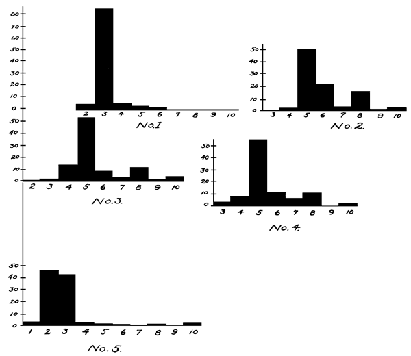
Plate VI.--Mechanical analyses of Comanchean sands.
Mechanical Analyses of Sands
| 1. White Cheyenne sandstone, Champion Draw section, 20 feet below top (see Plate VI, Fig. 1): |
||
|---|---|---|
| Standard mesh |
Size of openings (in mm) |
Percent retained |
| 48 | 0.295 | 4.80 |
| 65 | 0.208 | 85.50 |
| 80 | 0.175 | 5.70 |
| 100 | 0.147 | 1.71 |
| 115 | 0.124 | 1.50 |
| 150 | 0.104 | 0.04 |
| 170 | 0.088 | 0.20 |
| 200 | 0.074 | 0.04 |
| 200a | Pan | 0.26 |
| Total | 100.75 | |
Remarks. This material is wholly quartz, with the exception that all fractions below 48-mesh contain small percentages of gypsum. , All meshes to 115 have most of the grains polished, and about 10 per cent being spherical. The 150-, 170- and 200-mesh samples contain a large percentage of the grains sharply angular, although there are few spherical grains and some polishing and rounding. In the 200a-mesh material all the grains are sharply angular. The dimensions extend to microscopic sizes.
Conclusions. This sand is considered to be of stream production and of wind or stream deposition. The cross-lamination, inclined truncation and degree of assortment are believed to harmonize better with the view of wind deposition.
| 2. Cross-laminated white sandstone from lower portion of the 17-foot zone of the Natural Corral section (see Plate VI, Fig. 2): |
||
|---|---|---|
| Standard mesh |
Size of openings (in mm) |
Percent retained |
| 65 | 0.208 | 0.40 |
| 80 | 0.175 | 2.00 |
| 100 | 0.147 | 51.00 |
| 115 | 0.124 | 22.40 |
| 150 | 0.104 | 2.50 |
| 170 | 0.088 | 16.60 |
| 200 | 0.074 | 1.30 |
| 200a | Pan | 3.50 |
| Total | 99.70 | |
Remarks. The material is quartz and gypsum, the latter consisting of a few flakes in all fractions except the 200a-mesh, in which there is much finely divided gypsum. The fraction of the 150-mesh contains an occasional highly polished black grain which is not magnetic. There is essentially no rounding or polishing in any of the fractions.
| 3. Cross-laminated yellow sandstone from zone below the 172-foot zone of the Natural Corral section (see Plate VI, Fig. 3): |
||
|---|---|---|
| Standard mesh |
Size of openings (in mm) |
Percent retained |
| 48 | 0.295 | 0.03 |
| 65 | 0.208 | 2.27 |
| 80 | 0.175 | 14.40 |
| 100 | 0.147 | 56.12 |
| 115 | 0.124 | 8.81 |
| 150 | 0.104 | 3.13 |
| 170 | 0.088 | 11.34 |
| 200 | 0.074 | 1.04 |
| 200a | Pan | 3.38 |
| Total | 100.52 | |
Remarks. The material is wholly quartz with flakes of selenite, which in the 65 and smaller-mesh fractions rise to as much as 3 per cent. The fraction from the 65-mesh screen contains a few granules of opaque material with rusty exteriors which may be pyrite. The 48-mesh screen contains about 10 grains of elliptical or spherical shapes; all others are sharply angular. In all other meshes essentially every grain is sharply angular. The 200-mesh has the grains decreasing to microscopic sizes.
| 4. Cross-laminated white sandstone, zone below the 17.5-foot zone, the main layer of the spring (see Plate VI, Fig. 4): |
||
|---|---|---|
| Standard mesh |
Size of openings (in mm) |
Percent retained |
| 65 | 0.208 | 3.5 |
| 80 | 0.175 | 7.7 |
| 100 | 0.147 | 56.2 |
| 115 | 0.124 | 12.6 |
| 150 | 0.104 | 6.2 |
| 170 | 0.088 | 11.4 |
| 200 | 0.074 | 0.7 |
| 200a | Pan | 1.6 |
| Total | 99.9 | |
Remarks. The material is almost wholly quartz, with an occasional flake of gypsum in every fraction. The fraction on 200a-mesh contains a small percentage of limonite in finely divided form. The grains of every fraction are sharply angular, but the fractions of the larger meshes contain an occasional spherical grain.
The sand and its structures have the characteristics of wind deposition, but the sand does not appear to be of wind production and may have been deposited by streams.
| 5. Red cross-laminated Cheyenne sandstone, Champion Draw section, Belvidere, Kan., from near the top, stained and cemented with limonite (see Plate VI, Fig. 5): |
||
|---|---|---|
| Standard mesh |
Size of openings (in mm) |
Percent retained |
| 35 | 0.417 | 2.31 |
| 48 | 0.295 | 46.42 |
| 65 | 0.208 | 43.86 |
| 80 | 0.175 | 2.12 |
| 100 | 0.147 | 1.70 |
| 115 | 0.124 | 0.76 |
| 150 | 0.104 | 0.11 |
| 170 | 0.088 | 0.77 |
| 200 | 0.074 | 0.08 |
| 200a | Pan | 1.89 |
| Total | 100.02 | |
Remarks. The materials consist throughout of quartz with an occasional grain of limonite, which in the 150-mesh comprises about 2 to 3 per cent of fraction. The 150-mesh also contains an occasional flake of selenite. The 35-, 48-, and 65-mesh contain grains quite well polished and with corners rounded off, but there are few spheres. The 80-, 100- and 115-mesh fractions have about 75 per cent of the grains polished and about 25 per cent sharply angular. In 150-mesh the percentage of angular grains rises to about 50 per cent, and in the 170-mesh about 75 per cent. The 200-mesh material shows very little rounding, and smaller dimensions show no rounding whatever. The sand of the 200a-mesh screen decreases to microscopic dimensions.
Correlation of the Kansas Comanchean
In the preceding discussion it has been tacitly assumed that the marine beds of the Kansas sequence are the thinned northern extension of the Washita of the Texas sequence. This appears to be the most reasonable conclusion in the light of present information. It is true that there are some things in the fauna which are of Fredericksburg aspect, but the species for the most part are more like those of the Washita. This correlation makes parts of the "Dakota" of Washita age, thus taking these portions from the Upper and placing them in the Lower Cretaceous as these two divisions have been defined in the United States. The Cheyenne lies beneath the Washita, and is therefore older. It contains a flora of dicotyledons which has led to its being correlated with the "Dakota," but which Berry states is little allied to, and older than, the flora of the Woodbine (80, pp. 399-390; 81). That the Cheyenne is older than much of the "Dakota" is also evident, but it is probable that it is of the same age as some of the strata of north Kansas which have been referred to that division. The "Dakota" appears to be a kind of wastebasket into which have been placed all mid-Cretaceous sandy strata containing a dicotyledonous flora or consisting of red sandstones. A part is probably of the age of the Cheyenne, another portion the continental equivalent of the Belvidere, and there is an upper portion younger than any of the marine strata.
In the Black Hills of South Dakota, Darton (60, pp. 526-532) found that the lower portion of what previously had been called the "Dakota" consists of four formations or members, to which he gave, from below upward, the names of Lakota, Minnewaste limestone, Fuson, and Dakota, the last being limited to those strata containing the dicotyledonous leaves generally considered as constituting the "Dakota" flora. No marine fossils were discovered in any of the formations, so that it is assumed that none is present. That the uppermost member correlates in a general way with the beds containing the "Dakota" flora of Kansas is considered probable, and it is possible that there is a partial equivalence between the lower strata and some portions of the Belvidere formation and the Cheyenne sandstone.
Strata which are the equivalent of the Washita were identified about fifteen years ago in Colorado near the base of sandstones which had previously been referred to the "Dakota" (64, pp. 661-668). The discovery was made by Stanton and Lee on Purgatoire river in a section which was ultimately divided and correlated as follows:
| 5. Benton shale | |
| 4. Dakota sandstone | 100 ft. |
| 3. Dark shale and shaly sandstones with a Washita fauna | 50 to 100 ft. |
| 2. Coarse, gray, cross-laminated sandstone | 15 to 60 ft. |
| 1. Morrison shales. |
It is possible that zone 2 is the equivalent of the Cheyenne, but correlation of terrestrial, or, for that matter, any kind of sediments on the basis of the lithology, has nearly all possible chances of being incorrect. Zone 3 contains species which are also in the Kiowa, and this zone is probably contemporaneous with some part of the Kiowa of Kansas.
In the description of the geology of the Apishapa quadrangle Stose (72, pp. 3-5) differentiated the strata containing marine fossils of Washita affinity as the Purgatoire formation. In his description of the Colorado Springs quadrangle Findlay (73) divided the Purgatoire formation into the Lytle sandstone member below and the Glencairn shale above. In the shales there are few fossils and none in the Lytle sandstone, but the correlation with the Purgatoire formation is considered established.
Sequence of Events During the Deposition of the Cheyenne, Belvidere and "Dakota" Formations
The sequence of events for Kansas from the first appearance of the Comanchean in the state is something as follows:
- Continental deposition by streams and winds on a coastal plain in a dry or semiarid climate--the Cheyenne sandstone.
- Kiowa--"Dakota" deposition.
- Shallow sea waters advanced northward to about the city of Salina, Kan.--Kiowa deposition.
- Retreat of the shore line toward southern Kansas, with continental deposition over the central and northern part of the state.
- Northward advance of the shore line to a position a little north of Salina-Mentor deposition.
- Retreat of the shore line southward with continental deposition over the central part of the state--post-Mentor continental deposition.
The Base of the Upper Cretaceous
Where shall the base of the Upper Cretaceous be drawn? Some have insisted that the Comanche series of this continent has the value of a system and the Upper Cretaceous of another, the former to be called the Comanchean, the latter the Cretaceous. There was most certainly a broad retirement of the sea at the close of Washita time and a considerable change between the faunas of the Washita and those of the Benton, and it would appear that the place in centtral Kansas at which to draw the plane between the Upper and Lower Cretaceous should be above the last appearance of the Washlita fauna. Many European students have correlated the Washita with the Cenomanian of the Upper or Neocretaceous of Europe (65, p. 1408; 67; 68, p. 513). The general drift of American opinion also appears to have been toward correlation of the Washita, at least the upper part of it, with the Cenomanian (71, p. 584; 81, p. 201, etc.). In Europe the Cenomanian witnessed a great transgression of the sea, which extended beyond the limits of the Lower Cretaceous sea, so that the European strata of the Cenomanian hold the same position with respect to invasion that is held by the Benton of the Plains (74, p. 412; 67, p. 168).
This brings forward the question as to what should constitute the boundary of a larger time unit. On the basis of diastrophism, the boundary of these two time units for Kansas and adjacent states should be placed at the top of the Washita and its equivalents. In Europe it apparently should be placed at the base of the Cenomanian, considered by many students as the equivalent of the Washita. Thus the diastrophic principle places the break on one continent at one level and on another continent at a different level. There ought to be nothing strange about this--it seems that such should be more normal than anything different--and the writer is inclined to the opinion that this ultimately will be found to be true for several of the larger time units just as soon as we can get away from the view that the order of events on this continent was the same as in the Old World. The writer would go still further and insist that such is quite likely to be found to be the case for some of the larger time units on the same continent, thus agreeing with Willis that "each region has experienced an individual history of diastrophism, in which the law of periodicity is expressed in cycles of movement and quiescence peculiar to the region," and "the periods of diastrophic activity" have been, "as regards the whole surface of the earth, in general, not contemporaneous."
The theory of universal time breaks for all the continents grew up within the last century, on the assumption that either all the continents or the oceans moved as a whole at the same time, and received tremendous support from the views of Suess, with his postulate of the sinking of the ocean basin to account for the lowering of the strand line and the rising of the land. Chamberlin and Salisbury gave it further support when they asserted that "deformation movements begin with a depression of the bottom of the ocean basins, by which their capacity is increased," withdrawing the water from the epicontinental seas, thus bringing about a general raising of the strand line because of the probable connection of all the oceanic basins with each other (67, p. 192). The writer wishes that this theory of universal depression or elevation of the strand line could be established, as it would immensely simplify the problems of intercontinental stratigraphy and those of opposite sides of the same continent, but he considers the wish essentially impossible of realization. That some withdrawals of the sea were of this general character is possible, and such might constitute the chief division points of the geologic time scale--perhaps the boundaries between eras--but the view that local regional elevation and depression takes place on the continents irrespective of what the ocean and other continents are doing seems to him to rest on a firmer basis of fact. That the separation of the geologic time table into periods is based on such local withdrawals of the sea seems far more probable than that such planes of division are due to general withdrawals of the sea over all the continents.
If the bounding planes between divisions of the geologic column of periodic rank are determined by local regional withdrawals of the sea, how is it to be decided for each continent as to what constitutes a period? In order for nomenclature relating to the geologic time scale to be of value to geologists and students in general, the larger time units, as nearly as possible, should have the same limitations on one continent as on another, and if the above postulate be valid it means that after the boundaries of a system have been determined on one continent they will have to be arbitrarily fixed for other continents on a basis of paleontologic criteria, irrespective of where the diastrophic breaks may be. If done otherwise, a term given to a period will mean one thing on one continent and something else on another. This would mean that as the boundary between the Lower and Upper Cretaceous has been determined in Europe, the limitations of these divisions in North America will have to be determined on paleontologic criteria. The application of this principle makes it necessary to place the strata under consideration in the Upper Cretaceous.
The writer would compare the divisions of geologic history of one continent, in their relations to the geologic history of another, to the divisions of the history of man. The great divisions of American and European history have been based on great events in the history of the white race, and ultimately these high points may become the basis for the division of the history of all people, the histories of other peoples being made to conform to the divisions in the histories of American and European peoples. Did one study Chinese history, the high points would be at other times. They might coincide in some instances; in most they would not. It may ultimately come to pass that another civilization with different antecedents may supplant the existing one, and to this civilization the high points of the present civilization may have no significance. So the high points in European geologic history may have no relation to the high points in American geologic history; and as the limitations of many of our geologic time divisions were established in the former country, those of the latter should be drawn on paleontologic criteria to agree with the former, irrespective of where the diastrophic breaks occur.
Prev Page--Description || Next Page--COELENTERATA, ANNELIDA, ECHINODERMATA
Kansas Geological Survey, Geology
Placed on web February 2006; originally published 1924.
Comments to webadmin@kgs.ku.edu
The URL for this page is http://www.kgs.ku.edu/Publications/Bulletins/9/05_struct.html