![]()
Prev Page--Introduction || Next Page--Structure
Detailed Description of the Comanchean and "Dakota" Formations
Southern Kansas
The strata of southern Kansas here to be described are those which have previously been called the Cheyenne sandstone, Kiowa shale and Medicine beds, the upper member of the last-named having been usually identified as the "Dakota" sandstone. On the pages which follow these strata are designated the Cheyenne, Belvidere and "Dakota" formations, the Cheyenne without modification of previous usage, the Belvidere consisting of the lowest two members of the "Medicine beds," and the Kiowa shale, thus reviving the name proposed by Hill (46); and the "Dakota" including the uppermost two "Medicine" members, which are considered the attenuated southern extensions of the "Dakota" formation to the north.
Cheyenne Formation
The Cheyenne sandstone was named by Cragin (29, p. 65) in 1890 from Cheyenne Rock, opposite the village of Belvidere. A year later (31, p. 31) he gave its distribution and characteristics, while in 1895 he added considerably more detail and divided the formation from above downward as follows (47):
| Cragin's Classification of the Cheyenne Sandstone | ||
|---|---|---|
| Cheyenne sandstone | ||
| Elk creek beds | ||
| Stokes Hill sandstone | ||
| Lanphier beds | ||
| Corral sandstone (base) | ||
The Corral sandstone was named from exposures in the "Natural Corral," a box canyon about 5 miles southeast of Belvidere. The thickness of this member was estimated at 30 to 50 feet (32). At the type of locality it is a white to yellow sandstone of medium grain and is not uncommonly striped with yellows and reds along the bedding and lamination planes. Cross-lamination with steep foresets, which in large part appear to have southerly inclinations, are extremely common. The average length of the foresets exceeds 3 to 5 feet, with lengths up to 50 feet not uncommon. Gypsum crystals and impregnations are of general occurrence.
The Elk Creek beds. were so named from exposures about the head of Elk creek, the lower portion being differentiated, by Cragin as the Lanphier beds from exposures on the Lanphier ranch about 5 miles southeast of Belvidere, where this member consists of 10 to 15 feet of poorly cemented sands in which are streaks and lenses of black to gray shale. Cross-lamination is extremely common in the sandstones. Fragments of lignite, crystals of gypsum (selenite) and limonite concretions are commonly present, the last in all sorts of shapes. Many portions of the member are locally richly impregnated with gypsum. Another characteristic is the presence of logs composed of lignite and pyrite. All parts of the Elk Creek beds contain remains of dicotyledonous planto. The Stokes Hill sandstone is a yellow, medium-grained sandstone which was named from Stokes, or Black Hill, a few miles west of Sun City. The sandstone is only a few feet thick.
Sections which are illustrative of the Cheyenne sandstone, showing its variations in character and thickness from place to place, follow.
| Section at Osage Rock, three-quarters mile west of Belvidere | Thickness | |
|---|---|---|
| Feet | Inches | |
| 4. Champion shell bed | ||
| 3. Cross-laminated, fine-grained, soft sandstone with thin layers of dark carbonaceous shale; contains fossil leaves of dicotyledons | 26 | 0 |
| 2. Massive, cross-laminated, fine- to medium-grained yellow sandstone, containing pebbles of chert and quartz and lenses of bluish clay | 16 | 0 |
| 1. Permian | ||
| Section three miles south of Belvidere | Thickness | |
|---|---|---|
| Feet | Inches | |
| 5. Champion shell bed | ||
| 4. Gray to yellow, clayey, fine-grained sandstone | 15 | 0 |
| 3. Massive-bedded, white to gray, cross-laminated sandstone; contains pebbles of chert and quartz | 12 | 0 |
| 2. Black carbonaceous shale with a thin bed of sandstone | 6 | 0 |
| 1. Brown to gray, medium-grained, cross-laminated sandstone; contains pebbles of chert and quartz | 12 | 0 |
| Section in Champion Draw, one-half mile south of Belvidere | Thickness | |
|---|---|---|
| Feet | Inches | |
| 10. Champion shell bed | ||
| 10. Sandy gray shale with remains of fossil dicotyledons | 9 | 0 |
| 9. Soft, fine-grained, gray and yellow sandstone with bands of shale and carbonaceous material | 10 | 0 |
| 8. Dark sandy shale with much lignite and plant material | 12 | 0 |
| 7. Usually soft, yellow, fine-grained, cross-laminated sandstone with lignite in lenticular masses of shale. On the west bank near the top of the bluff is a hard ledge containing the best fossil leaves of dicotyledons found in this region | 20 | 0 |
| 6. Yellow and brown sandy shale with streaks of lignite and dark shale. Much cross-lamination, grades into zone 5 | 6 | 0 |
| 5. Soft, fine-grained, cross-laminated sandstone with lenses of dark shale, contains plants and sandstone concretions | 10 | 0 |
| 4. Yellow sandy shale with thin bands of lignite and dark shale. The lignite and shale bands contain plant remains. Generally cross-laminated | 8 | 0 |
| 3. Massive-bedded sandstone with many limonite concretions and pebbles of chert and quartz. Generally, greatly cross-laminated and streaked with different colors along the lamination planes. Contains lenticular bands of dark laminated clay | 20 | 0 |
| 2. Yellowish-gray shale | 3 | 0 |
| 1. Permian red beds | 50 | 0 |
| Section at Stokes or Black Hill, about five miles west of Sun City and six to seven miles southeast of Belvidere | Thickness | |
|---|---|---|
| Feet | Inches | |
| 3. Dark-gray sandy and clay shale with occasional lenses of friable yellow sandstone. Contains pyrite concretions and gypsum crystals and impregnations. Leaf impressions of dicotyledons are common | 10 | 0 |
| 2. Light to yellowish-gray, fine-grained friable sandstone; much cross-laminated; varies greatly in thickness | 40 | 0 |
| 1. Permian red beds | ||
| Section at Avilla Hill, an outlier on the Oklahoma line | Thickness | |
|---|---|---|
| Feet | Inches | |
| 3. Kiowa shale | ||
| 2. Quartzitic sandstone interbedded with soft sandstone. Colors vary from yellow to red. Contains poorly preserved pelecypods and probably is Kiowa | ||
| 1. Permian red beds | ||
Considered as a whole the Cheyenne sandstone consists of light gray to yellow quartz sandstone and subordinate shale. The bedding is extremely irregular and discontinuous and most beds are merely lenses of limited extent. The writer does not consider it possible definitely to recognize any member beyond the limits of one locality, and the divisions of Cragin to which reference has been made are considered to have no validity for more than local application; and as his three members were not differentiated in the same section it is possible that two of them may be one. At any rate, no definite continuous boundary can be pointed out to separate any two of them, and the sections show that there is wide variation in thickness. Cross-lamination is extremely common throughout, the inclinations tending to be steep and in large part appear to have southerly direction. Current ripple marks are common; wave ripple marks have not been recognized definitely. While the colors are commonly gray to yellow, and probably were originally so, iron staining, believed to be due to oxidation of pyrite or marcasite, is extremely common. Where the staining has taken place along bedding and lamination planes, the rock has been striped with almost every shade of color produced by the iron staining. The grains of the sands vary from extremely fine to the coarseness of fine gravel. In some horizons the texture is almost flourlike, while other horizons are characterized by rather well-assorted small pebbles of chert, quartz and clay, a few with diameters as large as two inches. Diagrams given on Plate VI show the assortment of typical examples. Gould reports pebbles of granite (59, p. 17). Interbedded with the sandstones are pockets and lenses of sandy and clay shale. Pyrite is abundant in some horizons; selenite crystals are extremely common and selenite needles occur throughout; limonite concretions, believed to result from weathering, are locally common. As a rule/the sandstones are poorly cemented, but locally they are quartzitic. The degree of cementation varies with the beds, so that some of them are protective to those below and project on weathered surfaces.
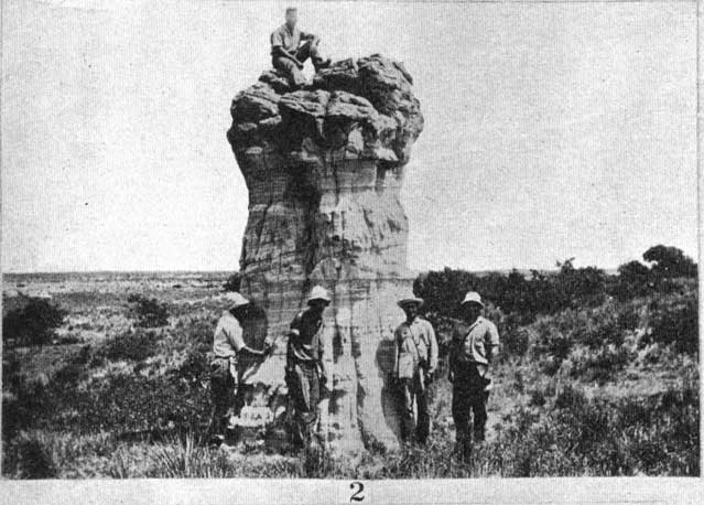
The strata of the Cheyenne formation are not extensively exposed. In the canyons and along the river valleys they commonly form the lower portions of the cliffs and the valley slopes, while in areas where the Kiowa shales have been removed and the sandstones directly exposed to erosion, a bad land topography has almost invariably developed. Pillars of fantastic shapes are common in such places. (Pl. II, Fig. 2). Bad land areas are not numerous or large, the most extensive being in southeastern Kiowa County in a place locally known as "Hell's Half Acre"--an appropriate design nation. Some of the better cemented portions of the Cheyenne resist erosion'and are locally known as "rocks." Such is Cheyenne Rock, on Medicine Lodge river opposite Belvidere, and Osage rock, on the north side of the river, just above Belvidere, the latter a place of historic interest as the site of a battle between the Cheyenne and Osage Indians.
Plate II. Views of erosion features on Comanchean strata. [Photos inserted closest to reference.]
Fig. 2. Erosion remnant of the Cheyenne sandstone, Hell's Half Acre, Comanche County. Photograph by Victor Householder.
The Cheyenne sandstone appears to be confined to the eastern part of the area occupied by the Kiowa. It was not seen by the writer in the western exposures, nor has it been reported by other students. It is possibly represented in the Avilla Hill exposures by 6 feet of quartzitic sandstone containing poorly preserved pelecypods. Southward the Cheyenne disappears, for in the Oklahoma sections the Kiowa is said to rest directly on the Permian.
Fossil leaves and other vegetable matter--logs and branches, lignitized, pyritized, and as casts--are locally quite common in some horizons of the Cheyenne sandstone, particularly in the upper part. The first species of plant described from this formation is a cycad named Cycadoidea munita by Cragin (28, p. 65; 47, p. 363), who also described foliage as belonging to Glyptostrobus gracillimus Lx. Large collections of fossil plants have been made from the formation by Hill and members of his field party, these having been identified by Knowlton and later described by Berry (81). [Note: 3. In a letter (August 17, 1920) Prof. Edward W. Berry states: "I have spent some months studying the flora of the Cheyenne sandstone and that of the Woodbine formation. . . . My results may be stated thus: Nearly all of the Cheyenne sandstone plants are called Dakota forms but not one of them occurs in the Woodbine or in any of the Coastal Plain formations that have been commonly correlated with the Dakota (Tuacalooaa, Raritan, Magothy, etc.). The Woodbine plants are also nearly all so-called Dakota forms, but in this case nearly all occur in Coastal Plain formations that have been correlated with the Dakota. The evidence is clear that the Cheyenne is older than the Woodbine and it is equally clear that whilte the go-called Dakota flora has a similar general facies throughout it is not all of the same age." Berry's published conclusions (81) relating to the Cheyenne flora are to the same point.] No animal remains have been collected from the formation unless the strata at Avilla Hill with the poorly preserved pelecypods are a part of the Cheyenne. It is far more probable that these beds are of Kiowa age. The flora identified from the formation is given in the following list (81):
| Abietites ernestinae Lesquereux | Feistmantelia oblonga Ward |
| Abietites longifolia (Fontaine) Berry | Gleichenia bohemica (Corda) Berry |
| Aralia polymorpha Newberry | Gleichenia nordonskioldi Heer |
| Aralia raviniana Heer | Sapindopsis belviderensis Berry |
| Araliopsoides cretacea (Newberry) Berry | Sapindopsis brevifolia Fontaine |
| Arundo groenlandica Heer | Sapindopsis magnifolia Fontaine |
| Asplenium dicksonianum Heer | Sapindopsis variabilis Fontaine |
| Carpolithus belviderensis Berry | Sassafras medgii Lesquereux |
| Cladophlebis dakotensis (Lesquereux) Berry | Sterculia condita Lesquereux |
| Cupressinoxylon cheyennense Penhallow | Sterculia mucronata Lesquereux |
| Cycadeoidea munita Cragin | Sterculia towneri (Lesquereux) Berry |
| Cycadeospermum lineatum Lesquereux |
Berry's table shows that ten of these species also occur in the "Dakota" sandstone, as that term is used by him (81, p. 206).
The features of the Cheyenne sandstone which throw light on the conditions of origin are the discontinuity of bedding, the cross-lamination, the assortment of the sands, the presence of land plants, and the absence of shella of marine animals. The presence of the gypsum, which is more or less scattered throughout the sandstones, must also be considered. As noted, the bedding is extremely discontinuous and the formation presents great variability in lithology and thickness, all of which implies a lack of uniformity in the depositing agencies. Cross-lamination is almost invariably present, the inclination appearing to have dominantly southerly directions. The foresets are commonly steep and long, the maximum lengths observed being those in the Champion Draw section where there are some which are at least 50 feet long at inclinations of about 20 degrees. In considerable part these cross-laminations are truncated in horizontal planes, but some have inclined truncation. This suggests wind deposition for these portions. The assortment of the sands is generally good, but occasional layers and laminae of mixed grain are present. The assortment is shown in the graphs on Plate VI. The gypsum, which occurs quite generally throughout the formation, may have been deposited at the same time as the sands, but, on the other hand, it may have been introduced subsequently to deposition. It has appeared to the writer that the gypsum is more abundant in those places where the sandstones are still overlain by the Kiowa shales, and this suggests that it may have been brought into the sands by waters which leached it from the shales above. The fact that the overlying Kiowa shales are full of endogenous gypsum indicates that the climate of Kiowa time-in this region was not humid; but, on the contrary, that more water evaporated in this gulf than was brought in by the rivers. This suggests that the climate may not have been greatly different from the present.
The relation of the Cheyenne sandstones to the overlying Kiowa shales suggests that the place of deposition of the former was not far above or far from a shore line, which indicates that the deposits are either shallow-water marine or stream, and perhaps, in part only, wind deposits of a coastal plain. Most of the bedding structures could have been developed under either condition. In shallow marine waters in which the sea bottom is near the profile of equilibrium redeposition of sediments constantly occurs, with scouring and great inequality of deposition; cross-lamination, cross-bedding, and discontinuity are the rule in such an environment.
Since, however, the sandstones contain an abundance of vegetable matter in some horizons, it seems strange that this complex of material could have been deposited under marine conditions and not contain any shells of marine animals. The vegetable matter appears to have floated in, for nothing has been found suggesting that the vegetation grew where it now occurs.
On a somewhat dry coastal plain, aggrading streams would spread sands over their flood plains and deltas with a discontinuity of bedding similar to that which is now found in the Cheyenne sandstones. The wind would help to produce the assortment and give the inclined truncation to the cross-lamination, while the clays, logs and leaves could have been brought from the sources of the streams and deposited in a manner similar to that which permits the deposition of sand, mud, logs and vegetable material in the deposits now forming on the aggraded floors of some of the canyons existing in the region. Under these conditions it is extremely unlikely that any marine shells would be present, and accordingly this environment appears to be more probable than any other. Although the Kiowa shales contain remains of aquatic vertebrates, none have been found in the Cheyenne sandstones. Were these sandstones of marine origin it seems that some remains of marine animals should be entombed, and since such are not present, it would seem that the animals either were not able to reach the places of deposition or there was nothing to attract them in the cases of a few which could have gone either on land or in the shallow waters of the sea. The fact that animal remains have not been found permits the inference that they are not present, and hence that the sandstones were deposited under conditions which either prohibited or were not favorable to the presence of animals. Such would have been the environment of a coastal plain in an arid or semiarid climate, where streams from lands to the north and west spread sediments which they were unable to carry through to the sea. Goldman's study of a sample of the Cheyenne sands suggests a somewhat similar environment (81, 204).
Belvidere Formation
The Belvidere formation as defined in this report includes the Kiowa shale, Spring Creek shale and Greenleaf sandstone members.
Kiowa Member. Cragin's classification of the different divisions of the Kiowa member is as follows:
| Kiowa shale | ||
| Tucumcari shale | ||
| Fullington shale | ||
| Blue Cut shale | ||
| Black Hill shale | ||
| Champion shell bed | ||
In this classification the "Champion shell bed," which has a thickness not exceeding a foot and a half, is given a stratigraphic value coordinate with the Cheyenne sandstone and the remainder of the Kiowa member (47). This is not justified by the facts, and on the pages which follow the term Kiowa will be used with the significance given it by Cragin in his first definition (43); that is, including all the beds from the top of the Cheyenne to the top of the typically marine strata of the section, but excluding the Spring Creek shale and the Greenleaf sandstone of Gould. These last do not appear to have been known to Cragin at the time of his definition of the term Kiowa, or at least they were not differentiated by him.
The Kiowa shales rest conformably on the Cheyenne sandstone. [Note: 1. There is evidence, at least locally, of an unconformity between the Cheyenne and Kiowa divisions. The upper surface of the Cheyenne just north of Belvidere is irregular, depressions in the sandstone being filled with horizontally laminated Kiowa shale.--R. C. Moore.] The contact is sharply defined and abrupt and is thought to represent the change from continental to marine conditions. The plane of contact is the strand line surface of erosion made by a transgressing sea. Bedding is well defined and regular, the units are continuous for long distances, and some are possibly continuous over the entire area of the exposures. Detailed descriptions of the units follow.
The Champion shell bed varies in thickness from 6 to 18 inches and is a fossil coquina of small Gryphaeas, together with some other shells. The matrix is varied, in some places consisting of shell fragments and sand and in others of sand and clay. Almost everywhere there is an abundance of gypsum which locally forms the matrix for the shells and iron pyrite. The oxidation of the latter leads to the disintegration of the rock and the destruction of the shells. As the member is more resistant than the strata immediately above and below, there is a rather general development of a terrace on this horizon, as is well shown throughout the Belvidere-Sun City region and around the heads of some of the draws. This bed has not been recognized in the Ashland-Bluff creek region.
Including the species described from this bed by Cragin and those concerning whose identity it is not likely he could have been mistaken, the list of fossils from the bed contains a total of 27 species and varieties. Cragin listed 36 species:
| Anchura kiowana Cragin | Neries? incognita Cragin |
| Astrocoenia nidiformis Cragin | Pecten frederickburgensis Cragin |
| Cardita belviderensis Cragin | Pholadomya? belviderensis, n. sp. |
| Cardium? bisolaris Cragin | Pinna comancheana Cragin |
| Cardium? kansasensis Meek | Protocardia texana Conrad |
| Corbula crassirostrata Cragin | Pteria belviderensis Cragin |
| Cucullaea recedens Cragin | Salenia kansasense, n. sp. |
| Engonoceras belviderei Cragin | Schloenbachia kiowana, n. sp. |
| Exogyra texana Roemer | Serpula championi Cragin |
| Gryphaea corrugata Say | Tapes belviderensis Cragin |
| Gryphaea corrugata hilli Cragin | Turritella seriatim-granulata belviderii Cragin |
| Limopsis subimbricatus Cragin | Tylostoma elevata (Shumard) |
| Margarita newberryi Cragin | Vanikora propinqua Cragin |
| Margarita marcouana Cragin |
Cragin identified Ostrea subovata Shumard and Holectypus planatus Roemer, which may possibly also be present.
The Fullington shales were divided by Cragin into the Black Hill shale and the Blue Cut shale, the former being named after Black (or Stokes) Hill, near Hell's Half Acre, in Comanche County, and the latter from the Blue Cut, on the Santa Fe railroad a few miles west of Belvidere. The Black Hill shale contains few fossils and was stated by Cragin to be 15 to 20 feet thick (47, p. 380). The unit consists mostly of black paper shale and appears to be the equivalent of zones 2 to 6 of the Belvidere section as given in this paper. The Blue Cut shale is on the average less dark than the beds below, but consists of shale of a similar character, in which fossils are extremely common. This unit is thought to include about zones 7 to 13 of the writer's Belvidere section.
The Tucumcari shales make up the upper portion of the Kiowa. The strata in this zone are considerably more limy than are those below, and are particularly characterized by the presence of large Gryphaeas.
While the differentiation of these units may be advisable in certain sections, it does not appear probable that the differentiation has any great validity. There are no sharp lines of separation and the units cannot be followed through the entire extent of the exposures. Considered as a whole, the Kiowa formation consists of shales and interbedded thin limestones. The shales in the lower half are commonly black and the laminae in the lower part have a thickness as thin as coarse wrapping paper. These, black shales contain few identifiable fossils, and such as are present are generally small. A few layers contain pebbles of quartz and brown chert. Limestone layers, generally thin, occur throughout, but are more common in the upper half. Most of them are fossil coquinas. Gypsum, usually in the form of a selenite, is common throughout.
The following 40 species and varieties of invertebrates have been identified from the Kiowa shales, exclusive of the Champion shell bed.
| Anchura kiowana Cragin | Neritoma marcouana Cragin |
| Anisomyon? cragini, n. sp. | Nucula catharina Cragin |
| Cardita belviderensis Cragin | Ostrea kiowana, n. sp. |
| Cardium kansasense Meek | Pecten texanus Roemer |
| Cardium? mudgeni Cragin | Petersia medicinensis Cragin |
| Cucullaea recedens Cragin | Pholadomya? belviderensis, n. sp. |
| Cyprimeria kiowana Cragin | Plicatula senescens Cragin |
| Dentalium, sp. | Protocardia texana Conrad |
| Engonoceras belviderensis Cragin | Pteria belviderensis Cragin |
| Exogyra texana Roemer | Remodia ferresi Cragin |
| Gervillia mudgeana White | Roudaria quadrans Cragin |
| Gryphaea corrugata Say | Schloenbachia belknappi, Marcou |
| Gryphaea corrugata belviderensis Hill and Vaughn | Schloenbachia kiowana, n. sp. |
| Gryphaea navia Hall | Schloenbachia peruviana von Buch |
| Leptosolen otterensis Cragin | Tapes belviderensis Cragin |
| Limopsis subimbricatus Cragin | Trigonia emoryi Conrad |
| Lingula, sp. | Trochus texanus Roemer |
| Lithophagus interrogatum Cragin | Turritella seriatim-granulata belviderii Cragin |
| Mactra antiqua Cragin | Tylostoma elevata Shumard |
| Margarita marcouana Cragin | Yoldia microdonta Meek |
There are no essential differences between the invertebrate faunas of the Champion shell bed and the overlying portion of the Kiowa shales, although Cragin considered the two faunas quite distinct. In addition to these, invertebrates, fragments of insects have been collected from thin beds of sandstone immediately above the Champion bed.
The vertebrates which are listed below, compiled from several publications, have been collected from the Kiowa shales;
| Coelodus browni Cope | Lower Cretaceous dinosaur Williston |
| Coelodus stantoni Williston | Mesodon? abraus Cragin |
| Cimolios annus Williston | Plesiochelys belviderensis Cragin |
| Hybodus clarkensis Cragin | Plesiosaurus mudgei Williston |
| Hyposarus? sp. Williston | Telost, vertebra like that of Portheus, Williston |
| Lamma sp. (toothlike L. Occidentalus Leidy) Williston | Turtle, size of Protostegia, Williston |
| Lamna? quinquelateralis Cragin | Uranoplosus arotatus Cope |
| Lepidotus sp. Williston | Uranoplosus flectidens Cope |
| Leptotyrax bicuspidatus Williston |
The sections which follow show in detail the character of the member throughout the extent of its exposures. The sections west of Sun City and near Belvidere are the most extensive.
| Section in Champion Draw, about one-half mile south of Belvidere (Plate II, Fig. 1) | Thickness | |
|---|---|---|
| Feet | Inches | |
| 19. Not well exposed, appeara to be largely gray shale and pink and gray Gryphaea shell limestone | 29 | 0 |
| 18. Pinkish, poorly cemented limestone with a thin layer of satin spar on top. Contains many Gryphaea corrugata, a few Turritella seriatim-granulata belviderii and Cyprimeria kiowana | 0 | 8 |
| 17. Shale, probably very dark-blue, weathered yellow in exposures, with interbedded fine-grained sandstone and gypsum. A few poorly preserved fossils in the sandstone; shale essentially without fossils | 38 | 0 |
| 16. Dark-blue and yellow shale, no fossils | 1 | 4 |
| 15. Gray and blue shale, crowded with Gryphaea corrugata | 0 | 4 |
| 14. Shell limestone, gray with pink patches. Contains Gryphaea corrugata in great abundance | 1 | 6 |
| 13. Black paper shale | 7 | 0 |
| 12. Gray shell limestone with patches of pink. Contains many small colored quartz pebbles, of which the diameter of the largest observed is about one-half inch. Cyprimeria kiowana very abundant | 0 | 6 |
| 11. Black paper shale | 4 | 0 |
| 10, Mottled gray and pink shell limestone. Contains some gypsum; many Cyprimeria kiowana | 0 | 8 |
| 9. Black paper shale | 5 | 0 |
| 8. Pink and gray shell limestone containing thin layers of satin spar. Contains an abundance of Gryphaea corrugata, Cyprimeria kiowana, Cardium kansasensis and Turritella seriatim-granulata belviderii | 0 | 6 |
| 7. Black paper shale | 11 | 0 |
| 6. Fine-grained gray quartz sandstone. Contains a few shell fragments and impressions | 0 | 4 |
| 5. Black paper shale | 4 | 0 |
| 4. Alternating thin bands of black and yellow shale, and thin, fine-grained gray quartz sandstone. The shale contains small concretions and quartz pebbles, the former containing fossils | 2 | 0 |
| 3. Black paper shale | 14 | 0 |
| 2. Fine-grained, friable gray sandstone filled with needles of selenite. Contains poor impressions of pelecypods, among which Tapes belviderensis occurs rarely [Note: Gould obtained remains of insects from a horizon not more than a foot above the Champion shell bed. They probably came from zone 3, but may have been derived from zone 2 (59, p. 24)] | 14 | 0 |
| 1. Champion shell bed. A highly gypsiferous shell bed, made up almost wholly of the shells of Gryphaea corrugata hUU. It is locally much iron-stained and contains a great deal of iron pyrite and gypsum, each in a few places serving as a matrix for the shells. The iron oxide is known to have been partly derived from the oxidation of the pyrite. Where the pyrite and the gypsum are most abundant the zone is thinnest and the shells most poorly preserved, largely because the oxidation of the pyrite has led to their decomposition. In many places the surface is covered with efflorescences of salt, gypsum, lime carbonate and sulphur. The zone is splendidly exposed about the head of the draw, where it forms the floor of a well-defined terrace with inclination in a southwesterly direction. Base of the Kiowa. Thickness ranges from 4 inches to... | 1 | 6 |
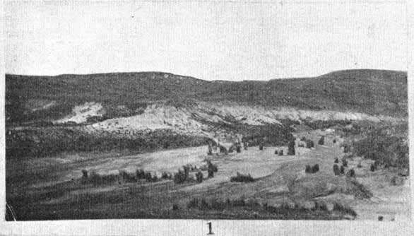
Plate II. Views of erosion features on Comanchean strata. [Photos inserted closest to reference.]
Fig. 1. View looking up Champion Draw. The hills in the background are composed of the Kiowa shales. The fiat surface in the middle is the aggraded floor of the draw. The white across the middle of the picture is the exposure of the Cheyenne sandstone, and to the left the dark beneath the white is the outcrop of the Permian red beds. Photograph by the author.
| Section at Black or Stokes Hill, about 5 miles west of Sun City | Thickness | |
|---|---|---|
| Feet | Inches | |
| 16. Covered slope to top of hill. Float on the top of the hill from the Kiowa | 16 | 0 |
| 15. Covered slope with Kiowa float of fine-grained yellow sandstone and pinkish limestone, the latter containing an abundance of Gryphaea corrugata, and an occasional Turritella seriatim-granulata belviderii and Cyprimeria kiowana | 32 | 0 |
| 14. Gray and yellow shale with an abundance of Gryphaea corrugata | 2 | 0 |
| 13. Black paper shale | 4 | 0 |
| 12. Gray shaly limestone in which there is an abundance of Cyprimeria kiowana | 1 | 0 |
| 11. Black paper shale | 4 | 0 |
| 10. Yellow shales and pinkish and gray shell limestone with an abundance of Gryphaea corrugata, Cyprimeria kiowana and Turritella seriatim-granulata belviderii | 1 | 0 |
| 9. Black paper shale | 5 | 0 |
| 8. Yellow and brown-shale with an abundance of Gryphaea corrugata | 1 | 0 |
| 7. Black and yellowish shale, the latter sandy and containing small pebbles of quartz | 8 | 0 |
| 6. Alternating layers of yellowish-gray sandy shales and black clay shale, with lenses of limestone up to about 2 inches thick | 2 | 0 |
| 5. Black paper shale | 4 | 0 |
| 4. Interbedded gray, black and yellow shale, some beds sandy. Contains small black chert pebbles and small concretions in some of which fossils occur. These are commonly fish teeth | 1 | 6 |
| 3. Black paper shale. A few poorly preserved fossils in basal portion | 16 | 0 |
| 2. White-clayey sandstone | 0 | 6 |
| 1. Champion shell bed, characters as in the Champion Draw section | 1 | 0 |
| Avilla Hill Section, (after Vaughan, 53, p. 40) | Thickness | |
|---|---|---|
| Feet | Inches | |
| 6. Capping of the Plains Tertiary gravel | ||
| 5. Yellow limy flagstone and shale with a layer about 10 feet and another about 20 feet from the top filled with Gryphaea | 70 | 0 |
| 4. Yellow clay shale with a few layers of sandstone | 35 | 0 |
| 3. Gray shell limestone containing many Gryphaea, Turritella, Cyprimeria and other fossils | 5 | 0 |
| 2. Black paper shale with a 1-foot bed of brown sandstone "about 10 feet above the base | 45 | 0 |
| 1. Yellowish clay shale | 5 | 0 |
| Bluff Creek Canyon section | Thickness | |
|---|---|---|
| Feet | Inches | |
| 17. White Tertiary marl | 15 | 0 |
| 16. Covered slope | 5 | 0 |
| 16. Fine-grained yellow sandstone | 0 | 6 |
| 14. Sandy yellow shale with fragments of Gryphaea corrugata | 2 | 0 |
| 13. Black shale | 4 | 0 |
| 12. Compact, mottled pink and gray shell limestone with a thin layer of satin spar on top. Contains many Gryphaea corrugata. Correlated with zone 18 of the Champion Draw section | 0 | 10 |
| 11. Covered slope with sandstone and limestone float. Probably mostly shale | 26 | 0 |
| 10. Thin-bedded gray sandstone | 2 | 0 |
| 9. Covered slope | 6 | 0 |
| 8. Sandy gray shells | 10 | 0 |
| 7. Thin-bedded yellow sandstone and gray shale | 1 | 0 |
| 6. Thin-laminated black shale | 40 | 0 |
| 6. Gray and pink shell limestone with a thin layer of satin spar on top, Makeup largely of shells of Gryphaea corrugata and Trigonia emoryi | 0 | 4 |
| 4. Black paper shale | 2 | 0 |
| 3. Sandy shale and fine-grained gray sandstone | 1 | 0 |
| 2. Black paper shale | 5 | 0 |
| 1. Friable, fine-grained white sandstone. May be the equivalent of the Cheyenne, but is conformable on the red beds, and is probably Permian | 12 | 0 |
| Little Basin section, western part of Clark County (after Prosser, 50, p. 171) | Thickness | |
|---|---|---|
| Feet | Inches | |
| 3. Tertiary sandstone | ||
| 2. Yellowish shale with Kiowa fossils | 15 | 0 |
| 1. Thin-laminated black shale, base of Kiowa | 13 | 0 |
This section shows the thinning of the Kiowa westward.
In the Kiowa section shown in Champion Draw, probably the most complete known, there are six repetitions of lithology, four of which consist of alterations of black paper shale and shell limestone, the former relatively thick, the latter quite thin and in the upper part, two of alternations of lighter-colored shale and limestone as below. In this statement the calcareous shale filled with shells, as illustrated by zone 15, is included with the limestone. These alternations represent six rhythms or cycles of sedimentation, the immediate cause of which is patent. The limestones were deposited when the deposition of black mud was not going on, the shale when the bottoms were not favorable for the existence of shelled animals. The explanation of this which appears most reasonable to the writer is that the transgressing Kiowa sea was intermittent in its advance, so that the sequence of events was somewhat as follows. For a period the sea moved northward rapidly over the Cheyenne sands, and the shallow-water life followed, the shell limestones representing the rock made by them. A quiescent period followed the advance, and mud deposits extended outward into the shallow waters, which may have been without open connection with the ocean to the south, due to the presence of Permian hills, then islands or peninsulas. The black muds were probably in considerable part the accumulations of vegetable matter from plants of low rank with habits similar to those of the plants which are now forming the black muds of the east Baltic region. [Note: Twenhofel, W. H., Notes on Black Shales in the Making. Am. Jour. Sci., 4th ser., vol. XL, pp. 271-280; 1915.] The black-mud deposition was terminated by another advance of the sea, and again the shallow-water life peopled the bottom, and was again repelled by a new extension outward of the black-mud environment. This repetition of events is assumed to have continued to the end. At the time of farthest advance the region of southern Kansas was beyond the area of black-mud deposition, so that yellow and blue muds were deposited, creating an environment in which shell life could make a home on the bottom. Farther south, in Texas, where there was more intimate connection with the open sea, black muds of the type present in the Kiowa shales did not generally appear.
If one could ascertain the length of time involved in the deposition of one of the laminations of the black paper shales, a fairly reliable estimate could be made of the minimum time involved in the deposition of that part of the Kiowa sequence which still remains. In some of the zones the thickness of the individual laminations approximate a millimeter, and the hypothesis that each lamination represents one season's deposition seems for the present the most reasonable assumption. On this basis it would have required 2,100 years to deposit the shale of zone 3 of the Belvidere section, or 150 years to one foot. If the limestone was accumulated at the rate of one foot in 1,000 years, the Champion shell bed required from 1,000 to 1,500 years for its development. Since oysterlike shells accumulate with great rapidity, it is probable that 1,000 years for the accumulation of one foot is too low a rate of deposition. As there are about 100 feet of shale in the Champion Draw section--not all of this is black paper shale--the rate of 150 years for a foot would give 15,000 years as the time required for the deposition of the shale. The limestones which are present in the section add roughly another 10,000 years to this figure, giving a total of 25,000 years as the approximate time required for the deposition of the strata present in the Champion Draw section. As there were probably many times when no deposition was going on, due to the bottoms having been built up to the profile of the equilibrium, this figure should probably be greatly increased.
Spring Creek Member. The upper two members of this formation were defined by Gould, and with the overlying strata were described as the Medicine beds (55). The sequence given by him is shown below, the origin and character of the organic content being also given:
| Reeder sandstone | "Dakota" flora | Continental |
| Kirby clays | "Dakota" flora | Continental |
| Greenleaf sandstone | Kiowa fauna | Marine |
| Spring Creek clays | Kiowa fauna | Marine |
The writer is not certain to what extent the differentiation of the Spring Creek and Greenleaf members as distinct from the Kiowa is justified, but since it has been done, and there are differences in the character of the sediments, it is considered best to continue the usage of these terms.
The Spring Creek member, named from a creek west of Belvidere, consists of bluish, greenish and yellowish clays and shale in which there are concretions of impure limonite. Its contact with the underlying Kiowa is not sharply defined. The thickness is around 50 feet for the maximum. The member contains the fossils listed below (59, p. 26):
| Cardium cf. kansasensis Meek | Ostrea quadriplicata Shumard |
| Corbula sp. | Pholadomya? cf. belviderensis, n. sp. |
| Cyprimeria cf. kiowana Cragin | Plicatula sp. |
| Gryphaea corrugata Say | Protocardia cf. texana Conrad |
| Lingula sp. | Tellina sp. |
| Nucula or Leda sp. | Shark teeth and fish scales |
| Mactra sp. |
Greenleaf Member. The immediately succeeding Greenleaf member (the name derived from Greenleaf ranch, near the village of Belvidere) consists of light-gray to light-brown, massive-bedded, commonly cross-laminated sandstone. Nodules of clayey limonite are extremely common in some layers. The maximum thickness is around 50 feet, but there are not many places where this thickness occurs. The member is probably of marine origin as suggested by the poorly preserved fossils which are present. Those which have been identified are given in the list which follows (59, p. 26):
| Cyprimeria cf. kiowana Cragin | Turritella sp. |
| Lingula sp. | Shark teeth |
| Pholadomya? cf. belviderensis, n. sp. |
"Dakota" Formation
The strata of the "Dakota" formation consist of clay and sandstone. As a result of post-"Dakota" erosion the formation is not everywhere present above the Belvidere formation. Portions of these strata were identified as the "Dakota" by Cragin (43, p. 381) and designated the Reeder sandstone. Their relation to the marine strata was worked out by Gould, and to him is due the name of the underlying Kirby member. These strata are overlain by the plains Tertiary, the contact being one of erosion.
The Kirby member, so named from the Kirby ranch near Belvidere, consists of yellow and reddish clay and shale in which are interbedded thin layers of yellow, fine-grained sandstone. The thickness may attain 50 feet, but is generally much less. The member appears to be conformable on the Greenleaf sandstone. It is believed to be of continental origin, and the only organic remains which are said to have been found consist of fragments of dicotyledons.
The Reeder sandstone has the characteristics of the "Dakota" of the central part of the state. It was named from an occurrence near Reeder post office on Medicine Lodge river. The rock consists of dark-brown massive sandstones which are commonly cross-laminated, contain many pebbles of chert and quartz and are locally characterized by large nodular concretions. The maximum thickness is around 20 feet, but in most sections very little of this is present. The plants given in the list which follows were collected by Gould (59, p. 30) from this horizon, identifications made by Ward:
| Proterides daphnogenoides Heer | Eucalyptus geinitzi Heer |
| Embrothriteis daphneoides Lx. | Eucalyptus gouldi Ward |
| Laurus plutonia Heer | Eucalyptus sp. |
Sections which are typical of "Dakota" and Belvidere beds are given below:
| Section on Spring Creek, about IS miles west of Belvidere (after Gould, 55) | Thickness | |||
|---|---|---|---|---|
| Feet | Inches | |||
| 6. Covered slope underlain by the plains Tertiary | ||||
| "Dakota" sandstone | ||||
| 5. Reeder sandstone. Dark-brown, massive-bedded sandstone, generally cross-laminated and containing many pebbles and nodular concretions, the latter up to 3 feet in diameter. No fossils observed | 20 | 0 | ||
| 4. Kirby clay. Yellowish to reddish clay, more or less sandy and containing beds of light-yellow sandstone. Contains nodules of clay ironstone | 20 | 0 | ||
| Belvidere formation | ||||
| 3. Greenleaf sandstone. Light-gray to yellow sandstone, generally much cross-laminated and containing nodules of darkbrown to black clay ironstone | 55 | 0 | ||
| 2. Spring Creek clay | ||||
| (a) Blue to yellow clay, containing bands and concretionary masses of impure limonite. Outcrop of a reddish color | 20 | 0 | ||
| (b) Dark-brown clay ironstone, bedding undulatory and cross-laminated. Not everywhere present. Weathers into odd forms | 5 | 0 | ||
| (c) Green to yellow clay with 1 to 8 in. beds of gray shaley sandstone. Contains numerous iron concretions; many of these are geodic, but contain clay | 15 | 0 | ||
| 1. Kiowa shale. Black paper shale | 15 | 0 | ||
On the western part of the Comanchean outcrop the Kirby clay unit is not present, as is shown in the section which follows (modified after Gould, 59, p. 25):
| Chatman Creek section, about 12 miles northwest of Ashland | Thickness | ||
|---|---|---|---|
| Feet | Inches | ||
| "Dakota" sandstone | |||
| 4. Reeder sandstone. Light to very dark-brown sandstone, more or less massive-bedded and locally cross-laminated. Contains pebbles and large limonite concretions | 15 | 0 | |
| Belvidere formation | |||
| 3. Greenleaf sandstone. Massive-bedded, yellow to dark-brown sandstone, locally cross-laminated | 25 | 0 | |
| 2. Spring Creek clay. Yellowish to blue clay containing nodules of clay iron-stone | 25 | 0 | |
| 1. Kiowa shale | |||
Cheyenne, Belvidere and "Dakota" Strata Beneath Younger Formations (Southern Kansas)
What lies beneath the Tertiary cover to the north of the Cheyenne, Belvidere and "Dakota" exposures is not known, and the data in the possession of the writer are rather scanty. It is possible that none of the formations under consideration is present and that these rocks were all removed during the Tertiary erosion. A well drilled on the Tertiary near Minneola, about 10 miles west of the most northern exposures of Bluff creek canyon, gave the record which follows:
| Record of well near Minneola, Clark County. | |
|---|---|
| Formations | Feet |
| 8. Soil | 5 |
| 7. Yellow clay | 75 |
| 6. Gray sandstone | 41 |
| 5. Yellow gypsum | 4 |
| 4. Red rock | 4 |
| 3. Soft blue shale | 143 |
| 2. Hard white limestone | 2 |
| 1. Soft blue shale | 10 |
The white limestone shown in this record is probably the Day Creek dolomite of the Permian. The blue shale above, with the overlying red rock and the yellow gypsum, is probably also Permian. It is possible that the gray sandstone is Cheyenne, but it is more likely a part of the gray sandy marls at the base of the Tertiary. On this interpretation neither Comanchean or "Dakota" strata are present.
Central and Northern Kansas
The red and other sandstones and shales lying beneath the Benton shales have generally been known as the Dakota, and with this division were formerly included all the strata to the top-of-the Permian. The division as thus limited was known to contain marine fossils in at least one horizon. The discovery that some of these marine forms also occur in the Comanchean series of Texas was made by Cragin, and he found that there are two horizons in which such marine forms are present. A thin limestone-member near the base, containing fossils identical with those of the Kiowa to the south, he called the Kiowa shale (26, p. 37; 29, p. 80). A shell-bearing horizon some 50 feet above this horizon was named the Mentor beds (44, pp. 162-165), the type locality being near the little railroad station of that name in Saline County. Many years before, Meek had collected marine fossils in the "Dakota" of northeast Nebraska and southeast South Dakota (13, pp. 171-174), and Mudge, long before Cragin, had found fossils in the red sandstones later named the Mentor beds (6, p. 394).
Belvidere Formation
It is proposed in this paper to include all of the strata from the top of the Mentor horizon down to the Permian in the Belvidere formation and those above the Mentor in the "Dakota." It will not be possible to determine everywhere to which iormation certain beds belong, because of inability to prove the stratigraphic position; and as the Mentor drops out northward, it is not possible at. the present time to state the distribution of the Belvidere formation in the northern part of the state. [Note: In the writer's judgment, the Kansas "Dakota," as at present defined, includes non-marine strata which are the equivalent of the Belvidere formation, strata deposited on the retirement of the Belvidere sea and strata which were deposited immediately antecedent to the Benton invasion. The differentiation of theae three groups of strata has not yet been attempted. If continental deposition continued in this region from the Mentor to the Benton, it will not be possible to find a structural plane of separation in these sandstones and shales, and any dividing plane selected will have to be based on paleobotanic criteria.]
The term Mentor is used with the significance given it by Cragin in his first definition. The thin marine limestones near the base of the sequence is proposed to call the Windom member, from the extensive occurrence of these strata northeast of the village of that name. Zones 5 to 10 of the Natural Corral section are designated the Marquette member, while to the strata below the Windom member the name Natural Corral member is applied. It is not to be understood that these terms are given any significance other than that they conveniently serve to designate the occurrence of fossils and the stratigraphic position of exposures.
These different divisions are shown in few natural exposures. Thus the type locality of the Mentor beds has nothing other than float plowed up in a road ditch. Places where exposures have been found showing the strata in sequence are in the upland country forming the divide between Smoky Hill and Little Arkansas rivers between the village of Marquette on the north and Conway and Windom on the south, and on Spring creek, near the village of Brookville. The best exposures are in the vicinity of Natural Corral a box canyon about 5 miles southwest of Marquette (NW sec. 5, T. 18 S., R. 5 W.), McPherson County. At that locality the Mentor sandstone can be followed about the shoulders of the canyon and neighboring hills and its variations easily observed. Float from the Mentor beds, in most cases very close to the stratigraphic position, is extremely common over parts of Saline and McPherson counties. This float generally occurs in road ditches and plowed fields.
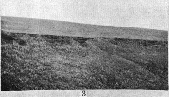
The section at the Natural Corral is composite, having been made from the many exposures in the canyon (Pl. II, Fig. 3), as follows:
| Section at the Natural Corral, McPherson County | Thickness | |
|---|---|---|
| Feet | Inches | |
| 12. Covered slope with Tertiary at the top, but float indicates the presence of red sandstone of the "Dakota" | 50 | 0 |
| 11. Cross-laminated, highly ferruginous and concretionary coarse red sandstone. The concretions are similar to those characteristic of the "Dakota." About 4 to 6 feet from the top is a horizon containing the typical Mentor fauna. Fossils may be present in other parts of this zone but they have not been observed. There are many places in the immediate vicinity where the zone appears to contain no fossils whatever. This in part may be due to original absence, but in some cases it appears probable that it is due to the development of limonite concretionary structures whose presence in places has so completely modified the rock that all original features have been obliterated. This zone forms the rim of the canyon and the shoulders of the bluffs in the immediate vicinity | 8 | 0 |
| 10. Cross-laminated, medium-grained, friable yellow sandstone; no fossils | 2 | 0 |
| 9. Friable, fine-grained, yellowish sandstone with a somewhat compact 6-inch band near the middle and another similar 2-inch band about 7 feet from the top. Locally the zone contains a little shale. It forms the upper portion of the cliff above the spring at the head of the east arm of the Corral, where it is thinner and more compact than indicated above. No fossils | 17 | 6 |
| 8. Compact yellowish-white sandstone; no fossils. Ranges from 7 feet to... | 8 | 0 |
| 7. Blue paper shale; no observed fossils | 10 | 0 |
| 6. Pale yellow sandstone, containing dicotyledonous leaves | 2 | 0 |
| 5. Blue gypsiferous shale | 14 | 0 |
| 4. Two 6-inch layers of gray shell limestone separated by gray shale. The limestone consists almost wholly of shells. The most common species being Ostrea kiowana, Cyprimeria kiowana, Cardium kansasensis and Turritella seriatim-granulata belviderii | 3 | 0 |
| 3. Dark-blue gypsiferous shale containing many crystals of yellow selenite, nodules of pyrite and a layer of cone-in-cone limestone. The cone-in-cone layer, or one very similar, has been found in a number of localities in Saline and McPherson counties where no fossiliferous strata are present | 16 | 0 |
| 2. Concealed, believed to be shale and sandstone | 14 | 0 |
| 1. Permian. Red, blue and yellow shales of the Wellington formation | 25 | 0 |
Plate II. Views of erosion features on Comanchean strata. [Photos inserted closest to reference.]
Fig. 3. Outcrop of the Mentor bed, Natural Corral. The fossiliferous bed is that exposed immediately below the rim of the canyon. Photograph by the author.
The only other place where a section of the marine strata is known to occur in Saline County is along the banks of Spring creek, near the village of Brookville. The section here is as follows:
| Section on Spring creek, near Brookville, Saline County | Thickness | |
|---|---|---|
| Feet | Inches | |
| 4. Yellow and gray sandstone overlain by reddish sandstone containing limonite concretions | 10 | 0 |
| 3. Thin laminated blue shale which locally carries limonite concretions. The largest of these have horizontal diameters up to a foot and a thickness up to 6 inches | 16 | 0 |
| 2. Friable, thick-bedded yellow sandstone, nearly one solid bed, containing poorly preserved Comanchean fossils | 6 | 0 |
| 1. Thin laminated black shales, to creek bed | 9 | 0 |
A section showing the character of the nonmarine strata which are believed to hold the stratigraphic position of the strata below the Mentor member is exposed on the south bank of Solomon river and an adjacent hillside one mile south of Bennington. This section is as follows:
| Section on south side of Solomon river, one mile south of Bennington | Thickness | |
|---|---|---|
| Feet | Inches | |
| 9. Mottled red, brown and yellow coarse-grained sandstone in which are mud pebbles. The rock is concretionary in spots. Exposed at the base to the extent of 6 feet, upper portion exposed only in spots. About two miles to the south on a horizon which seems to fall within this zone is a layer of cone-in-cone limestone like that of zone 3 of the Natural Corral section | 50 | 0 |
| 8. Friable white sandstone of medium grain | 12 | 0 |
| 7. Concealed | 3 | 0 |
| 6. Medium-grained, friable white sandstone in which are occasional harder bands | 6 | 0 |
| 5. Dark blue shale | 4 | 0 |
| 4. Fine-grained, friable yellow sandstone | 2 | 0 |
| 3. Blue shale | 2 | 0 |
| 2. Medium-grained, friable yellow sandstone | 8 | 8 |
| 1. Concealed to river level, probably of weak materials | 9 | 0 |
While these sections serve to show the sequence of strata in the central portion of the state, not one of them occurs in the localities where the strata are most fossiliferous. The best place at which to collect Mentor fossils is "in the road ditches and plowed fields about five miles west of the little village of Smolan, in Saline County. Here the rock is simply a mass of fossils--all molds--no shell matter being preserved. The best place to collect fossils from the Windom member is about 3 miles northeast of Windom village.
The sands of the Marquette member show every indication in some horizons of having been deposited by the wind. Mechanical analyses of some of these and other sands are shown on Plate VI.
The fauna of the Mentor beds is relatively large and extremely prolific in individuals of some species, varying greatly, however, with locality. Descriptions of thirty-one species are given on subsequent pages, and in addition there is considerable material too imperfect for description. The species are as follows:
| Anchura kiowana Cragin | Mactra siouxensis smolanensis, n. var. |
| Anisomyon? cragini, n. sp. | Margarita ornamentata n. sp. |
| Arcopagella mactroides Meek | Margarita mudgeana Meek |
| Barbatia parallela Meek | Natrea? smolanensis, n. sp. |
| Cardium kansasense Meek | Nerita semipleura, n. sp. |
| Corbicula elongata, n. sp. | Ostrea kiowana, n. sp. |
| Corbicula nucalis Meek | Ostrea quadriplicata Shumard |
| Crassatellina oblonga Meek | Protocardia texana Conrad |
| Cucullaea? gigantea, n. sp. | Pteria salinaensis White |
| Cucullaea? recedens Cragin | Siliqua mentorensis, n. sp. |
| Cyprimeria kiowana Cragin | Tellina subscitula Meek |
| Engonoceras belviderensis Cragin | Trigonia emoryi Conrad |
| Gervillia mudgeana White | Trigonarca salinaensis Meek |
| Leda acuminata, n. sp. | Turritella kansasense Meek |
| Leptosolen conradi Meek | Yoldia microdonta Meek |
| Linearia kansasensen. sp. |
The fauna of the Windom member is not large in species, but of some species it contains an abundance of individuals, particularly of Turritella and Ostrea. The species listed below have been identified:
| Anchura kiowana Cragin | Neritoma marcouana Cragin |
| Cardium kansasense Meek | Ostrea kiowana, n. sp. |
| Cyprimeria kiowana Cragin | Turritella seriatim-granulata belviderii Cragin |
| Engonoceras belvidereii Cragin |
"Dakota" Formation
The sequence of strata given by Logan (51) for the Kansas "Dakota" is as follows:
| Upper "Dakota" | ||
| (a) Gypsiferous dark shale | 10 to 20 ft. | |
| (b) Saliferous shale with thin sandstone layers containing marine fossils |
15 to 30 ft. | |
| (c) Shell bed | 6 in. | |
| (d) Shales like those above | 5 to 10 ft. | |
| (e) Lignite zone | 6 to 26 in. | |
To what extent this section is correct is not known to the present writer. According to Logan (82, p. 259), letter to Stanton, T. W., 1905, the Mentor beds have been included and assigned to the upper Dakota. This makes it desirable that the Kansas "Dakota" section be carefully restudied. It will probably be found far more complex than suspected.
Prev Page--Introduction || Next Page--Structure
Kansas Geological Survey, Geology
Placed on web February 2006; originally published 1924.
Comments to webadmin@kgs.ku.edu
The URL for this page is http://www.kgs.ku.edu/Publications/Bulletins/9/04_desc.html