![]()
Prev Page--Geology || Next Page--Chemical Character
Ground Water
Occurrence, Source, and Movement of Water
Ground water in Smoky Hill Valley occurs in the pore spaces of the gravel, sand, silt, and clay of the valley fill and terrace deposits. The depth below which these materials are saturated in the valley areas--that is, the depth to the water table--ranges from a few feet to about 40 feet below the land surface, but in most places it is between 20 and 30 feet. The rate at which water moves through these materials depends largely on the size and shape of the pore spaces and on the slope of the water table. The sand and gravel deposits of the alluvium generally contain relatively large, interconnecting pore spaces through which water moves freely under low water-table gradients. All the recorded wells in the Smoky Hill Valley area derive water from sand and gravel under water-table conditions. The high permeability of the sand and gravel in parts of the area is indicated by the large yields of some of the wells.
Beds and lenses of silt and clay are associated with the sand and gravel in the alluvium and in some places make up a large part of the alluvium. Clay and silt may contain large quantities of water where they occur below the water table, but because of the minute size of their pore spaces the water moves through them with extreme slowness even under high water-table gradients. Compact clay is essentially impervious.
The ultimate source of all ground water in the Smoky Hill Valley area is the precipitation upon this and near-by areas. A part of the water from rain and snow that falls on the valley floor, or falls on the valley sides and deploys on the valley floor, is carried off by streams, a part evaporates, and the remainder percolates directly into the ground. Part of the water that enters the ground is used by plants, but some eventually reaches the ground-water body in the alluvium. A part of the runoff from drainage areas tributary to the main valleys probably reaches the ground-water body in the alluvium through the channels of the small creeks and ravines that cross the valley to reach the large rivers. The large through-flowing rivers also furnish water to the ground-water reservoir in the alluvium. A discussion of the relation of Smoky Hill River to the water table is given later in this section.
Some water also percolates into the alluvium from adjacent formations. The slope of the water table in the sand hills area between Abilene and Solomon (Pl. 1, section E-E') indicates that water moves from the terrace deposits into the alluvium in this area. Further evidence of this is furnished by a study of the analyses of samples of water from the terrace deposits, from alluvium near the sand hills, and from alluvium farther out in the valley. The analyses indicate that the water in alluvium near the edge of the sand hills is a mixture of relatively soft water of low mineralization from the terrace deposits and hard, more highly mineralized water from other parts of the alluvium. At places where Permian water-bearing beds are in contact with alluvium, and where the pressure head of water in the Permian beds is greater than the head in the overlying alluvium, water can move from the Permian beds into the alluvium. Such movement is known to take place near Solomon, where water in alluvium of Smoky Hill and Solomon Valleys has been contaminated by highly mineralized water from the underlying Wellington formation.
Ground water in the terrace deposits is derived from precipitation on the surface of the dune area-an area that offers unusually good opportunities for recharge from precipitation as much of the rain that falls on the dune-covered area is absorbed by the sand. Part of the water that falls in the dune area during heavy rains gathers in shallow undrained depressions and forms temporary ponds (Pl. 6C). Part of this water evaporates but a part seeps downward and eventually reaches the ground-water body in the terrace deposits.
The available data indicate that the general movement of ground water in this area is down the valley and that the average slope of the water table is about 4 feet to the mile. The altitude of the water table is about 1,255 feet at Assaria, 1,240 feet at Mentor, 1,205 feet at Salina, 1,105 feet at Enterprise, and 1,050 feet at Junction City.
The relation of the water table to Smoky Hill River at Assaria, Mentor, Salina, and Enterprise is shown by profiles in Figure 5, and the relation of the water table to Smoky Hill, Republican, and Kansas Rivers in the vicinity of Junction City is shown by water-table contours in Figure 6. It will be noted that at Assaria and Mentor the water table is higher than the stream surface. Under these conditions ground water moves toward the river. At Enterprise the water table is slightly below the stream surface and at Salina it is several feet below the stream surface. This condition at Salina probably is caused by the heavy withdrawals of water from the Salina city wells. Under these conditions water will tend to move outward from the river to an extent governed by the available head and the permeability of the materials underlying the river bottom.
Figure 5--Relation of the water table to Smoky Hill River at Enterprise, Salina, Mentor, 2 miles south of Mentor, and Assaria. Based on July 1946 measurements.
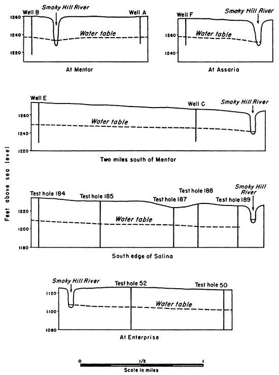
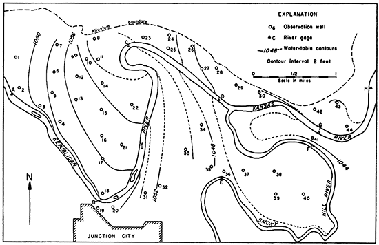
Figure 6--Water-table contours in the vicinity of Junction City. Based on water-level measurements and gauge readings made April 18-22, 1941, and furnished by the Quartermaster Corps, U. S. Army.
The amount of water percolating from the river during periods of normal or low flow probably is comparatively small because of the deposition of silt in the bottom of the channel. During high stages of the river the available head is increased, and in most or all sections of the river there is movement of water from the river toward the water table.
The measurements upon which the contours in Figure 6 are based were made during the period April 18-22, 1941, when the river flow was about normaL At this time Republican River above river gauge C was a losing stream, as indicated by the downstream flexure of the contours. Below river gauge C the ground water was moving obliquely across Republican River with very little change in direction at the river. Smoky Hill and Kansas Rivers during this period were both above the water table and losing water to the ground-water reservoir in this area. The water table does not remain as it is shown in Figure 6 but changes shape as water is added to or taken from the ground-water body. During periods of high water, the movement of water is everywhere away from the rivers at steeper slopes than is shown in Figure 6. During periods of low river flow, there may be a reversal of the water-table gradient near the streams, in which case water will move toward and into the rivers.
Fluctuations of Water Level in Wells
As was pointed out above, the water table does not remain in a stationary position but fluctuates up and down as water is added to or taken from the ground-water reservoir. Fluctuation of the water table is recorded by the change in the water level in wells. A well that is measured periodically to observe the change in the height of its water level is called an observation well.
In January 1941 the Quartermaster Corps, U. S. Army, authorized the Widmer Engineering Company to make a study of the ground-water conditions in the valley areas of the Fort Riley Military Reservation. During January, February, and March 1941 a large number of observation wells were put down in Smoky Hill, Republican, and Kansas Valleys north and northeast of Junction City, and gauges were established on the rivers. Each observation well consisted of a 1 1/4-inch galvanized-iron pipe on the lower end of which was a screened drive point. A hole was first augered by hand to the water table, then the l;4-inch pipe and drive point were placed in the hole and driven several feet below the water table. Measurements of the water levels in these observation wells and readings of the river gauges were made weekly from April 18 to June 4, 1941, by personnel of the Quartermaster Corps. A flood early in June destroyed the river gauges and filled most of the wells with sand and debris. Personnel was not available at that time to repair the damage done by the flood, and therefore the program was discontinued.
The locations of 44 of the observation wells and 8 river gauges are shown in Figure 6. Table 2 lists the depths and altitudes of the observation wells and Table 3 lists the available water-level measurements. Altitudes of the water surface at the 8 river gauges are given in Table 4.
Table 2--Depths and altitudes of driven observation wells put down by the Widmer Engineering Company for the Quartermaster Corps, U. S. Army, at the Fort Riley Military Reservation, Kansas. Wells put down in January-March 1941 and abandoned in July 1941. Each consisted of a 1 1/4--inch galvanized-iron pipe with a screened sand point at the lower end. Measuring point of each well was at the top edge of the pipe.
| Well number on Fig. 6 |
Depth of well, feet |
Altitude of measuring point, feet |
|---|---|---|
| 1 | 23 | 1,078.9 |
| 2 | 23 | 1,077.6 |
| 3 | 28 | 1,076.4 |
| 4 | 23 | 1,073.9 |
| 5 | 28 | 1,074.1 |
| 6 | 28 | 1,079.9 |
| 7 | 28 | 1,077.4 |
| 8 | 43 | 1,081.8 |
| 9 | 33 | 1,076.9 |
| 10 | 28 | 1,073.2 |
| 11 | 28 | 1,074.7 |
| 12 | 28 | 1,074.3 |
| 13 | 28 | 1,075.1 |
| 14 | 23 | 1,069.7 |
| 15 | 23 | 1,070.6 |
| 16 | 23 | 1,071.1 |
| 17 | 28 | 1,072.7 |
| 18 | 23 | 1,071.7 |
| 19 | 38 | 1,082.8 |
| 20 | 28 | 1,077.9 |
| 21 | 23 | 1,070.3 |
| 22 | 23 | 1,067.3 |
| 23 | 43 | 1,080.3 |
| 24 | 38 | 1,079.6 |
| 25 | 48 | 1,081.2 |
| 26 | 38 | 1,068.5 |
| 27 | 28 | 1,065.1 |
| 28 | 28 | 1,065.0 |
| 29 | 23 | 1,060.6 |
| 30 | 18 | 1,055.8 |
| 31 | 1,065.4 | |
| 32 | 18 | 1,069.7 |
| 33 | 23 | 1,069.3 |
| 34 | 23 | 1,064.0 |
| 35 | 1,061.7 | |
| 36 | 28 | 1,066.6 |
| 37 | 23 | 1,068.1 |
| 38 | 28 | 1,064.2 |
| 39 | 18 | 1,057.7 |
| 40 | 33 | 1,067.8 |
| 41 | 28 | 1,063.8 |
| 42 | 28 | 1,062.0 |
| 43 | 23 | 1,059.1 |
| 44 | 18 | 1,053.9 |
Table 3--Water levels in observation wells at the Fort Riley Military Reservation, in feet below the measuring point, 1941 (For location of wells refer to Plate 1; for descriptions refer to Table 15)
| Well number | April | May | June | ||||||||||||||||
|---|---|---|---|---|---|---|---|---|---|---|---|---|---|---|---|---|---|---|---|
| 18 | 21 | 22 | 24 | 25 | 30 | 1 | 7 | 8 | 14 | 15 | 20 | 21 | 26 | 27 | 28 | 2 | 3 | 4 | |
| 1 | 17.01 | 16.78 | 16.61 | 16.68 | 16.80 | 16.81 | 16.60 | 16.52 | |||||||||||
| 2 | 16.55 | 16.23 | 16.30 | 16.35 | 16.32 | 16.51 | 15.74 | 16.12 | |||||||||||
| 3 | 16.86 | 16.61 | 16.59 | 16.62 | 16.49 | 16.59 | 16.09 | 16.38 | |||||||||||
| 4 | 16.51 | 16.34 | 16.28 | 16.29 | 16.26 | 16.44 | 15.98 | 16.06 | |||||||||||
| 5 | 16.80 | 16.81 | 16.74 | 16.67 | 16.67 | 16.65 | 16.56 | 16.41 | |||||||||||
| 6 | 22.82 | 22.81 | 22.57 | 22.68 | 22.69 | 22.70 | 22.66 | 22.56 | |||||||||||
| 7 | 19.67 | 19.52 | 19.43 | 19.38 | 19.40 | 19.36 | 20.51 | 19.50 | |||||||||||
| 8 | 31.07 | 30.81 | 30.76 | 30.94 | 31.16 | 31.23 | 31.09 | 30.99 | |||||||||||
| 9 | 22.55 | 23.12 | 23.11 | 23.23 | 23.22 | 23.24 | 23.00 | ||||||||||||
| 10 | 20.39 | 20.57 | 20.60 | 20.60 | 20.70 | 20.48 | 20.45 | ||||||||||||
| 11 | 23.75 | 23.48 | 23.56 | 23.20 | 24.02 | 23.51 | 23.87 | 22.87 | |||||||||||
| 12 | 19.90 | 19.95 | 19.85 | 19.45 | 19.87 | 19.91 | 19.91 | 19.74 | |||||||||||
| 13 | 19.63 | 19.61 | 19.48 | 19.47 | 19.46 | 19.47 | 19.37 | 19.26 | |||||||||||
| 14 | 15.94 | 15.92 | 15.82 | 15.77 | 15.78 | 15.64 | 15.55 | ||||||||||||
| 15 | 15.69 | 15.69 | 15.57 | 15.50 | 15.43 | 15.49 | 15.23 | 15.25 | |||||||||||
| 16 | 15.59 | 15.56 | 15.47 | 15.69 | 15.29 | 15.34 | 15.23 | 15.12 | |||||||||||
| 17 | 16.72 | 16.66 | 16.51 | 16.49 | 16.20 | 16.44 | 16.24 | 16.21 | |||||||||||
| 18 | 15.62 | 15.34 | 15.30 | 15.35 | 15.27 | 15.62 | 14.84 | 15.23 | |||||||||||
| 19 | 29.75 | 29.65 | 29.31 | 29.58 | 29.04 | 28.64 | 28.00 | 28.75 | |||||||||||
| 20 | 21.67 | 20.45 | 21.42 | 22.37 | 21.55 | 21.80 | 21.39 | ||||||||||||
| 21 | 15.30 | 15.23 | 15.10 | 15.07 | 14.90 | 15.03 | 14.86 | 14.77 | |||||||||||
| 22 | 13.81 | 13.75 | 13.60 | 13.58 | 13.57 | 13.55 | 13.24 | 13.21 | |||||||||||
| 23 | 30.90 | 30.69 | 30.47 | 30.37 | 30.35 | 30.36 | 29.90 | 29.84 | |||||||||||
| 24 | 30.78 | 30.53 | 30.61 | 30.79 | 30.85 | 31.07 | 29.82 | 30.54 | |||||||||||
| 25 | 31.75 | 31.76 | 31.94 | 32.01 | 32.14 | 33.36 | 31.23 | 31.75 | |||||||||||
| 26 | 22.15 | 21.87 | 21.47 | 21.78 | 21.95 | 22.13 | 20.84 | 21.72 | |||||||||||
| 27 | 19.14 | 19.02 | 18.80 | 19.02 | 18.93 | 19.76 | 17.53 | 18.03 | |||||||||||
| 28 | 19.80 | 19.78 | 19.38 | 19.64 | 19.46 | 19.24 | 18.38 | 18.62 | |||||||||||
| 29 | 15.29 | 15.15 | 14.85 | 14.91 | 14.61 | 15.04 | 14.08 | 13.99 | |||||||||||
| 30 | 10.97 | 10.68 | 10.53 | 10.67 | |||||||||||||||
| 31 | 11.95 | 11.80 | 11.60 | 11.66 | 11.58 | 11.73 | 11.23 | 11.31 | |||||||||||
| 32 | 17.86 | 17.81 | 17.62 | 17.46 | 17.34 | 18.32 | 17.25 | 17.01 | |||||||||||
| 33 | 18.62 | 18.60 | 18.76 | 18.47 | 18.37 | 18.33 | 19.32 | 18.26 | |||||||||||
| 34 | 15.39 | 15.36 | 15.29 | 15.25 | 15.16 | 15.07 | 15.08 | 14.96 | |||||||||||
| 35 | 13.23 | 13.19 | 12.85 | 13.09 | 13.03 | 13.01 | 12.93 | 12.77 | |||||||||||
| 36 | 20.28 | 20.22 | 20.02 | 20.01 | 20.02 | 19.80 | 19.30 | 19.15 | |||||||||||
| 37 | 22.71 | 22.65 | 21.35 | 22.37 | 22.38 | 22.42 | 22.04 | 21.89 | |||||||||||
| 38 | 19.70 | 19.63 | 19.44 | 19.46 | 19.33 | 19.44 | 19.08 | 18.94 | |||||||||||
| 39 | 13.22 | 13.18 | 12.60 | 12.93 | 12.83 | 11.70 | 12.78 | 12.57 | |||||||||||
| 40 | 23.64 | 23.70 | 23.41 | 23.39 | 22.33 | 23.27 | 23.19 | 22.96 | |||||||||||
| 41 | 23.30 | 19.83 | 19.74 | 20.25 | 19.83 | 20.10 | 18.26 | 18.55 | |||||||||||
| 42 | 19.12 | 18.99 | 18.64 | 18.59 | 18.63 | 18.94 | 17.96 | 17.57 | |||||||||||
| 43 | 17.05 | 16.98 | 16.79 | 16.55 | 16.48 | 16.58 | 16.39 | 15.87 | |||||||||||
| 44 | 11.40 | 11.75 | 11.40 | 11.49 | 11.49 | 11.66 | 10.42 | 10.30 | |||||||||||
Figure 7--Hydrographs showing the weekly water levels in observation wells 2, 3, 6, and 15 at the Fort Riley Military Reservation and the weekly stages of Republican River at gauge A. Location of the observation wells and river gauge are shown in Figure 6.
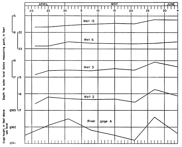
The period of observation of the water levels in these wells was too short to permit drawing any conclusions regarding the general trend of the water-table fluctuations. The weekly water levels in observation wells 2, 3, 6, and 15 are plotted in comparison with the weekly stage of Republican River at river gauge A in Figure 7. Wells 2 and 3 are within 500 feet of the river and wells 6 and 15 are about 2,700 and 3,300 feet from the river, respectively (Fig. 6). Wells 2 and 3 are close enough to the river that the fluctuations in their water levels follow very closely fluctuations of the water surface in the river. The water levels in wells 6 and 15 are also affected by the fluctuations of the water surface in the river, but the fluctuations of the water levels in these wells are of a smaller magnitude because they are farther from the river. Because water is transmitted through the ground very slowly there is generally some lag between the fluctuations of the river and fluctuations of the adjacent water table. The longer the river maintains a high stage, the farther from the river will the water table be affected. The high stages caused by floods are usually of short duration and, therefore, probably do not affect the ground-water levels very far back from the river.
Table 4--Height of gauges on Smoky Hill, Republican, and Kansas Rivers at the Fort Riley Military Reservation, from April 18 to June 4, 1941, in feet above sea level. Furnished by the Quartermaster Corps, U. S. Army. † Locations of gauges shown on Figure 6.
| Date, 1941 |
River gauge† | |||||||
|---|---|---|---|---|---|---|---|---|
| A | B | C | D | E | F | G | H | |
| April 18 | 1,045.7 | 1,043.7 | 1,040.6 | |||||
| April 21 | 1,061.5 | 1,057.8 | 1,045.8 | 1,046.5 | ||||
| April 22 | 1,050.3 | |||||||
| April 24 | 1,046.5 | 1,046.8 | 1,046.6 | 1,048.8 | 1,042.0 | |||
| April 25 | 1,062.1 | 1,058.1 | 1,050.6 | |||||
| April 30 | 1,046.7 | 1,046.1 | 1,043.6 | 1,041.2 | ||||
| May 1 | 1,062.5 | 1,057.6 | 1,050.2 | 1,045.9 | ||||
| May 7 | 1,045.5 | 1,046.9 | 1,045.9 | 1,043.2 | 1,041.0 | |||
| May 8 | 1,061.8 | 1,058.0 | 1,050.4 | |||||
| May 14 | 1,046.5 | 1,046.5 | 1,041.5 | |||||
| May 15 | 1,061.5 | 1,057.9 | 1,050.0 | 1,045.7 | 1,046.6 | |||
| May 20 | 1,045.7 | 1,042.9 | 1,040.7 | |||||
| May 21 | 1,061.2 | 1,057.8 | 1,049.1 | 1,045.4 | 1,046.5 | |||
| May 26 | 1,049.8 | 1,046.6 | 1,045.0 | |||||
| May 27 | 1,062.6 | 1,050.0 | 1,050.0 | |||||
| May 28 | 1,058.5 | |||||||
| June 2 | 1,049.0 | 1,045.9 | ||||||
| June 3 | 1,057.5 | 1,048.7 | ||||||
| June 4 | 1.061.6 | |||||||
In March 1946 the United States Geological Survey, cooperating with the United States Bureau of Reclamation, started an observation-well program in Smoky Hill Valley below the Kanopolis dam, which is situated on Smoky Hill River in eastern Ellsworth County, Kansas. As a part of this program, 11 observation wells were put down in Smoky Hill Valley in southern Saline County during March and April 1946, and monthly measurements of the water levels in them were begun in July. The location of these observation wells are shown on Plate 1 and descriptions of them are given in Table 5. The wells consist of 1 1/4-inch galvanized-iron pipe with screened drive points and were put down by John Sears, who used a hand auger and driving block. The water-level measurements for 1946, which were made with a steel tape by Mr. Sears, are given in Table 6. These and subsequent water-level measurements will be published in the annual water-level reports of the Federal Geological Survey.
Table 5--Records of driven observation wells in Smoky Hill Valley in southern Saline County, Kansas.
| No. on Plate 1 |
Location | Date constructed, 1946 |
Depth, feet |
Measuring point 1 | Depth to water level below measuring point,2 feet |
Date of measurement, 1946 |
|
|---|---|---|---|---|---|---|---|
| Distance above land surface, feet |
Height above sea level, feet |
||||||
| T. 15 S., R. 2 W. | |||||||
| A | SE SW sec. 17 | Mar. 27 | 30.7 | 0.35 | 1,261.6 | 24.13 | Mar. 28 |
| B | SE cor. SW sec. 18 | Mar. 28 | 43.7 | 1.35 | 1,262.7 | 25.52 | Mar. 29 |
| C | SE SW SE sec. 30 | Mar. 26 | 37 | 1.0 | 1,267.8 | 22.38 | Mar. 27 |
| T. 15 S., R. 3 W. | |||||||
| D | SE cor. sec. 24 | Mar. 27 | 36.8 | 1.23 | 1.264.9 | 20.1 | Mar. 27 |
| E | NW cor. NE sec. 36 | Mar. 26 | 45.9 | 1.1 | 1,275.4 | 26.4 | Mar. 26 |
| T. 16 S., R. 2 W. | |||||||
| F | NW cor. sec. 7 | Mar. 15 | 31.2 | .8 | 1.279.6 | 21 | Mar. 21 |
| G | SW cor. sec. 18 | Mar. 21 | 38.1 | .9 | 1.284.2 | 26.7 | Mar. 21 |
| H | NW NE sec. 19 | Mar. 21 | 38 | 1.0 | 1,279.8 | 24.9 | Mar. 21 |
| T. 16 S., R. 3 W. | |||||||
| J | SE SW sec. 13 | April 1 | 47.4 | 1.3 | 1,283.9 | 22.0 | April 1 |
| K | SW SE sec. 26 | April 9 | 27.8 | 1.25 | 1,304.3 | 21.9 | April 9 |
| L | SE SE sec. 34 | April 10 | 45.9 | 1.13 | 1,311.2 | 23 | April 10 |
| 1. Top edge of 1 1/4-inch pipe at each well. 2. Subsequent water-level measurements are given in Table 6. |
|||||||
Table 6--Water levels in observation wells in Smoky Hill Valley in southern Saline County, Kansas, in feet below the measuring point. (For descriptions of wells, see Table 5.)
| Well number |
1946 | ||||
|---|---|---|---|---|---|
| July 3 | Aug. 1 | Sept. 5 | Oct. 1 | Nov. 4 | |
| A | 24.96 | 25.15 | 24.89 | 24.32 | 23.19 |
| B | 26.13 | 26.22 | 26.38 | 25.65 | 24.30 |
| C | 23.05 | 23.35 | 23.42 | 22.89 | 21. 99 |
| D | 20.68 | 21.08 | 20.95 | 21.70 | 20.96 |
| E | 27.80 | 28.22 | 28.26 | 28.06 | 27.91 |
| F | 21.64 | 22.88 | 22.05 | 21.64 | 21.02 |
| G | 27.20 | 27.08 | 27.25 | 26.22 | 24.29 |
| H | 24.38 | 25.18 | 25.35 | 24.18 | 22.00 |
| J | 25.26 | 25.47 | 25.63 | 25.22 | 24.44 |
| K | 22.43 | 22.57 | 22.69 | 21.87 | 20.36 |
| L | 23.66 | 23.84 | 24.08 | 23.41 | 22.24 |
Sand Springs
The only spring of importance in the Smoky Hill Valley area is situated on the north bank of Smoky Hill River about 2.5 miles west of Abilene (No. 73, Pl. 1). About 300 feet north of the spring is the edge of the sand hills. Before any improvements were made this was a seepage area in which water issued from many small openings in the sandy alluvial deposits and discharged into the river. This seepage area was called Sand Springs and was an important watering point for early travelers and cattlemen.
In 1881 the Sand Springs area was developed as a source of water supply for the City of Abilene. The water plant, which was rebuilt by a private company in 1890, was purchased by the city in 1907. A pit about 30 feet deep and 30 feet in diameter was dug at the site of the springs and cased with stone. The water issues from a solution opening along a bedding plane in Permian limestone (Herington limestone member of the Nolans limestone) at the bottom of the pit. A number of residents of this area expressed the belief that the water at Sand Springs had traveled a great distance before being discharged at the spring. Contrary to this belief, the present study shows that the water is of local origin. The limestone through which the water issues is about 7 feet thick and extends only a short distance northward beneath the sand hills, where it is overlain by water-bearing terrace deposits. Water from the terrace deposits enters the limestone through fractures and solution openings and after traveling a short distance through the limestone (probably less than a quarter of a mile) is discharged at the spring. The relation between the terrace deposits and the spring is well shown by cross section E-E' on Plate 1.
The flow of Sand Springs is reported to fluctuate with the rainfall and ranges from less than 900 gallons a minute during periods of deficient rainfall to about 1,200 gallons a minute during periods of excessive rainfall. The water, although somewhat hard, is of unusually good quality as compared with the waters from alluvium in this area. An analysis (No. 73) of a sample of water from Sand Springs is given in Table 9.
Wells in Alluvium
Most water supplies in the area studied are obtained from wells in the Quaternary alluvium that fills the valleys. Records of 97 wells in the Smoky Hill Valley area that derive water from these alluvial deposits for domestic, stock, public-supply, industrial, and irrigation use were obtained. Descriptions of these wells are given in Table 15 and their locations are shown on Plate 1.
Construction of Wells
The most common type of domestic and stock well in this area is constructed of 1 1/4-inch or 2 1/4-inch galvanized-iron pipe on the lower end of which is a screened drive point (sometimes called "sand point"). These are generally put down by first augering a hole to water-bearing sand or gravel, using a hand augur, then placing the pipe with the drive point in the hole and driving it several feet into the water-bearing material. In some cases, especially for the deeper wells, the hole is drilled to the desired depth, then the pipe and screened point are placed in it. In this type of well the small-diameter pipe acts both as a discharge pipe and a casing. Some of the stock and domestic wells are drilled wells that have separate galvanized-iron or steel casings, which range from 5 to 10 inches in diameter. The depths of 54 domestic and stock wells on which information was obtained range from 14 to 84 feet. Of these wells, 10 are less than 30 feet deep, 34 are between 30 and 50 feet deep, and 9 are between 50 and 84 feet deep. Most of these wells are equipped with cylinder pumps operated by windmill or hand, or by both. Five of the wells are equipped with electrically operated cylinder pumps and one has a small gasoline engine.
All the public-supply, industrial, and irrigation wells are drilled wells and most of them penetrate the entire thickness of alluvium. The depths of 43 wells of this type for which records were obtained range from 38 to 86 feet. Of these wells, 7 are between 38 and 50 feet deep, 8 are between 50 and 60 feet deep, 16 are between 60 and 70 feet deep, and 11 are between 70 and 86 feet deep. The diameters of these wells range from 6 to 26 inches, but about two-thirds of them are 16, 18, 24, or 26 inches in diameter. Steel or concrete casings are most common, although a few wells have iron casings. Thirty-five of the 43 wells, including all the wells drilled in recent years, are gravel packed. All but one of the public-supply, industrial, and irrigation wells are equipped with turbine pumps, and of these, 37 are powered by electric motors, 4 by stationary gasoline engines, and 1 by a tractor. Well 40 at Chapman is equipped with a plunger pump and gasoline engine.
Although most of the public-supply, industrial, and irrigation wells are single wells, Nos. 40 and 57 are battery-well units consisting of three and four wells, respectively, each group connected to a single pump. Well 57 was abandoned in 1943 and well 40 is operated onJy during periods of emergency.
Yields of Wells
The yields of wells in the Smoky Hill Valley area vary widely. Important factors that determine the yield of a well are the construction, the diameter of the well casing, the type of casing and perforations, the development and finishing of the well--whether gravel-packed or not--the age of the well, and the character and thickness of the water-bearing material. The quality of water may also be an important factor, for water that readily forms incrustations may eventually fill the perforations in the well casing, thus causing a decrease in the yield of the well. The water-bearing sands and gravels in the alluvial deposits of Smoky Hill, Kansas, Republican, Solomon, Saline, and Mulberry Valleys in this area are in most places highly permeable and sufficiently thick to furnish moderate to large quantities of water to properly constructed wells. In the smaller tributary valleys the alluvial deposits are thinner and consist mostly of fine material having low permeability. Therefore, wells in these areas can be expected to have relatively low yields.
Farm wells that supply water for domestic and stock purposes generally yield only a few gallons a minute and are pumped only when the water is needed. Public-supply, industrial, and irrigation water is derived from wells that are constructed to yield larger quantities of water. The reported operating yields of 39 wells of this type ranged from 50 to 1,500 gallons a minute. Of these wells, 6 yielded less than 250 gallons a minute, 5 between 250 and 500 gallons a minute, 12 between 500 and 1,000 gallons a minute, and 16 between 1,000 and 1,500 gallons a minute.
Data on the measured yield and drawdown for 31 public-supply and irrigation wells were obtained from the Layne-Western Company, Paulette and Wilson, Engineers (now Wilson and Company), and the Division of Water Resources of the Kansas State Board of Agriculture, and are given in Table 7. For most wells these measurements were made during pumping tests conducted at the time the wells were drilled. The measured yields of the wells tested ranged from 50 gallons a minute to 1,700 gallons a minute and averaged about 860 gallons a minute. The drawdowns ranged from 3 feet to 25.3 feet. Also given in Table 7 is the specific capacity for each well The specific capacity of a well is its rate of yield per unit of drawdown and in this report it is given in gallons a minute per foot of drawdown. The specific capacities for the 31 wells tested ranged from 16.7 to 185.4 and averaged 81.5. Of the 31 wells, 6 had specific capacities of less than 50, 19 had specific capacities between 50 and 100, and 6 had specific capacities of more than 100.
Utilization of Ground Water
During the course of the investigation information on 98 wells and one spring in the Smoky Hill Valley area was obtained. Of the 98 wells, 55 are domestic and stock wells, 35 are public-supply wells, 7 are irrigation wells, and 1 is an industrial well. The principal uses of ground water in this area are described below.
Domestic and Stock Supplies
Most of the farms in the Smoky Hill Valley area have one or more small-diameter wells that supply water for domestic or stock use. At some farms one well supplies water for both purposes, but many have separate wells-one for domestic use near the house and one for stock use near the barn or in a pasture. Domestic and stock wells generally do not extend through the entire thickness of alluvium but penetrate only a few feet into the water-bearing sand and graveL Although the chief reason for this is the lower construction cost, in some areas, especially in the vicinity of Solomon, it is because the deeper waters are harder and more highly mineralized than the shallow waters.
No attempt was made to obtain information on all domestic and stock wells in this area. The 55 wells of this type for which records were obtained represent only a small percentage of the total number of such wells. These wells were visited primarily to collect samples of water for chemical analyses. The water in the Smoky Hill Valley area is hard, but generally is satisfactory for domestic and stock use. In the Solomon area some of the ground waters contain undesirable quantities of chloride or sulfate and in other places the ground waters locally contain undesirable amounts of iron (see chemical character of ground water).
Table 7--Yield, drawdown, and specific capacity of 31 public-supply and irrigation wells in the Smoky Hill Valley area 1.
| Well number (Pl. 1, Table 15) |
Location | Discharge, gallons a minute2 |
Drawdown, feet |
Specific capacity, gallons a minute per foot of drawdown |
|---|---|---|---|---|
| 14 | Republican Valley, Geary Co. | 980 | 25.3 | 38.7 |
| 15 | Republican Valley, Geary Co. | 1,000 | 18 | 55.5 |
| 18 | Republican Valley, Geary Co. | 1,000 | 11.5 | 86.9 |
| 19 | Republican Valley, Geary Co. | 1,025 | 16.7 | 61.4 |
| 21 | Republican Valley, Geary Co. | 500 | 8 | 62.5 |
| 22 | Republican Valley, Geary Co. | 500 | 6 | 83.3 |
| 23 | Republican Valley, Geary Co. | 500 | 5 | 100 |
| 24 | Republican Valley, Geary Co. | 1,700 | 15.7 | 108.2 |
| 25 | Kansas Valley, Geary Co. | 1,000 | 6 | 166.7 |
| 26 | Kansas Valley, Geary Co. | 1,020 | 6.2 | 164.5 |
| 27 | Kansas Valley, Geary Co. | 1,020 | 7.2 | 141. 7 |
| 28 | Kansas Valley, Geary Co. | 1,020 | 5.5 | 185.4 |
| 41 | Smoky Hill Valley, Dickinson Co. | 200 | 8 | 25 |
| 56 | Smoky Hill Valley, Dickinson Co. | 305 | 17.5 | 17.6 |
| 60 | Smoky Hill Valley, Dickinson Co. | 1,360 | 16.02 | 85 |
| 91 | Smoky Hill Valley, Dickinson Co. | 50 | 3 | 16.7 |
| 92 | Smoky Hill Valley, Dickinson Co. | 50 | 3 | 16.7 |
| 127 | Smoky Hill Valley, Saline Co. | 1,500 | 19 | 78.9 |
| 168 | Smoky Hill Valley, Saline Co. | 1,090 | 11 | 99.1 |
| 169 | Smoky Hill Valley, Saline Co. | 850 | 16.9 | 50.4 |
| 170 | Smoky Hill Valley, Saline Co. | 1,020 | 11. 7 | 87.1 |
| 171 | Smoky Hill Valley, Saline Co. | 900 | 14.5 | 62 |
| 172 | Smoky Hill Valley, Saline Co. | 1,120 | 10 | 112 |
| 173 | Smoky Hill Valley, Saline Co. | 1,040 | 13.5 | 77 |
| 174 | Smoky Hill Valley, Saline Co. | 1,090 | 20 | 54.5 |
| 175 | Smoky Hill Valley, Saline Co. | 1,040 | 13.5 | 77 |
| 200 | Smoky Hill Valley, Saline Co. | 750 | 7.5 | 100 |
| 201 | Smoky Hill Valley, Saline Co. | 776 | 9.5 | 81. 7 |
| 202 | Smoky Hill Valley, Saline Co. | 781 | 8.8 | 88.8 |
| 203 | Smoky Hill Valley, Saline Co. | 830 | 8.3 | 100 |
| 204 | Smoky Hill Valley, Saline Co. | 750 | 16.9 | 44.4 |
| 1. Well 60 tested by Division of Water Resources, Kansas State Board of Agriculture; wells 91 and 92 by Paulette and Wilson, Engineers; all others by the Layne-Western Company. 2. Average rate of discharge during test. |
||||
Public Supplies
The cities of Milford, Junction City, Chapman, Enterprise, Solomon, Salina, and Assaria have public water systems supplied by ground water pumped from wells, and Abilene has a public water system supplied by ground water from a spring. Smaller communities in the Smoky Hill Valley area are supplied from private wells, each family having a well of its own. In addition to the cities, each of the following military centers have public water systems: Fort Riley, the Cavalry Replacement Training Center near Fort Riley, Camp Funston, and Camp Phillips. The Smoky Hill Army Air Base receives its water from the Camp Phillips system. Descriptions of the public water supplies follow.
Milford--Milford (population 258) is supplied by one well (No. 1 in Table 15) situated at the southwest edge of town that taps alluvium in Republican Valley. The well is 38 feet deep and 18 inches in diameter, and is gravel-packed. It has a reported yield of 150 gallons a minute. Water is pumped from the well directly into the mains, the excess water going to a 50,000-gallon elevated steel storage tank located on a high bluff in the northeast part of town. The average daily consumption of water at Milford is reported to be about 15,000 gallons. The water is hard, but otherwise it is of good quality and is not treated (see analysis 1, Table 9).
Junction City--Junction City (population 9,524) is supplied by four wells (16-19) located on the south side of Republican River at the" north edge of town that tap alluvium in the Republican Valley (see logs 18 and 19). Wells 16 and 17 are, respectively, 67 and 54 feet deep and pump 400 and 500 gallons a minute. The diameter and type of casing in these wells are not known. Wells 18 and 19 are, respectively, 54 and 52 feet deep, pump 700 and 850 gallons a minute, and are cased with 19-inch concrete casing. Both are gravel-packed. These two wells (city wells 4 and 5) furnish most of the supply and are pumped directly into the city mains, the excess water going to two steel storage tanks on a high bluff at the southwest edge of town. Wells 16 and 17 (city wells 2 and 3) are used only in emergencies. Water is pumped from these wells to a small sunken reservoir nearby and from there to the two tanks at the southwest edge of town. The total storage capacity of the three reservoirs is about 250,000 gallons.
The monthly consumption of water at Junction City for the 5- year period from January 1938 to December 1942 ranged from 20,772,000 to 58,934,000 gallons and averaged 30,750,000 gallons. Approximately 95 percent of the water consumed is used by the inhabitants and 5 percent is furnished to manufacturing plants and the railroad. An analysis (19) of a sample of water from well 19 is given in Table 9. The water is moderately hard and, except for being disinfected by chlorine, is not treated.
Fort Riley Military Reservation--The Cavalry Replacement Training Center, Fort Riley, and Camp Funston on the Fort Riley Military Reservation, each have a separate water-supply system.
The Cavalry Replacement Training Center obtains its water from two gravel-packed wells (14 and 15) that tap alluvium in Republican Valley 1.75 miles north of Junction City (see logs 14 and 15). These wells are 26 inches in diameter and are 81 and 74 feet deep, respectively. Each well has a reported yield of 1,200 gallons a minute. The water is reported to be moderately hard and is treated with chlorine and sodium hexametaphosphate (Calgon).
Fort Riley is supplied by four gravel-packed wells (21-24) on the northeast side of Republican River about 0.75 mile above its confluence with Smoky Hill River. The wells are 66 to 70 feet deep and derive water from alluvium (see logs 21-24). Wells 21-23 were drilled in 1928 and have 18-inch concrete casings. Well 24 was drilled in 1937 and has a 26-inch steel casing. The wells are only 300 to 500 feet apart, and because of the close spacing there is interference between wells, which decreases the yield of each well when the others are pumping. The yields of the wells range from 200 to 1,100 gallons a minute when all wells are pumping, the aggregate yield being about 2,800 gallons a minute. The yields are somewhat greater when the wells are pumped individually. According to partial analyses furnished by Army engineers, the waters from the four wells at Fort Riley contain 0.5 to 3.4 parts per million of iron and have hardnesses of 283 to 481 parts.
Four gravel-packed wells (25-28) were constructed during the winter of 1940-41 in Kansas Valley about 6 miles below Junction City to supply water to Camp Funston. Logs (25-28) of these wells are given at the back of this report. The wells are 61 to 64 feet deep and 26 inches in diameter, and have steel casings. They are reported to yield 1,200 gallons a minute each when pumped separately. The water is reported to be hard and to contain undesirable amounts of iron. Wells 27 and 28, nearest the river, are seldom used because of the high iron content of the water.
Chapman--Chapman (population 873) obtains most of its water supply from one gravel-packed well (41) in the western part of town. This is an old railroad well that was reconstructed by the city in 1939. It is 68 feet deep, is cased with 19-inch concrete casing, and taps alluvium in Smoky Hill Valley (see log 41). The well is reported to yield 200 gallons a minute with a drawdown of 8 feet. The supply at Chapman was formerly derived from a pumping unit constructed in 1912. This unit is situated at the west edge of town and consists of three drilled wells (40) connected to one plunger pump driven by a gasoline engine. These wells, which are spaced about 15 feet apart, are 68 feet deep and are cased with 10-inch iron casing. They have a reported aggregate yield of 225 gallons a minute. This well unit is kept in operating condition for emergency use only.
Water is pumped from the wells directly into the mains, the excess water going to a 100,000-gallon concrete standpipe on a bluff at the northwest edge of town. The daily capacity of the system is about 400,000 gallons, and the average daily consumption is about 70,000 gallons. The water is very hard, as shown by analyses 40 and 41 in Table 9. It is chlorinated but receives no other treatment.
Enterprise--Until recently Enterprise (population 706) was supplied by four wells (57) about 250 feet north of Smoky Hill River north of town. The wells, which are spaced 25 feet apart at the corners of a square, are 38 feet deep and 8 inches in diameter, and have iron casings. They are connected to one turbine pump having a capacity of 500 gallons a minute. Decrease in the aggregate yield of these wells caused by packing of fine sand around the casings or by incrustation of the well casings resulted in their being abandoned in 1943, and a new well was drilled. The new well (56) is about 75 feet west of the old wells, is 41.5 feet deep, has 19-inch concrete casing, and is gravel-packed (see log 56). During a pumping test conducted at the time the well was constructed it had a yield of 305 gallons a minute with a drawdown of 17.5 feet after pumping 8 hours. The capacity of this well is reported to have declined considerably since it was drilled.
Water is pumped directly from the well into the distribution mains, the excess water going to a 300,000-gallon elevated steel storage tank near the center of town. Figures on the consumption of water at Enterprise are not available. The water is very hard, as indicated by analysis 56 in Table 9, but otherwise it is of good chemical quality and is not treated.
Abilene--Abilene (population 5,539) obtains its water supply from Sand Springs (73), located on the north bank of Smoky Hill River 2.5 miles west of town. A detailed description of the spring is given on pages 46-47. The reported capacity of the spring ranges from 900 gallons a minute during prolonged dry periods to 1,200 gallons a minute during periods having normal or excessive precipitation. Three plunger pumps at the spring pump the water through a 12-inch pipe line to two elevated steel storage tanks at the west edge of Abilene. The total storage capacity of the two tanks is 750,000 gallons. Distribution to the consumers is by gravity. The monthly consumption of water at Abilene ranges from 17,000,000 to about 33,000,000 gallons and averages about 21,000,000 gallons, of which about 2,400,000 gallons is supplied to railroads. The water is moderately hard, as indicated by analysis 73 in Table 9, but otherwise it is of excellent chemical quality and, except for intermittent chlorination, it is not treated.
Abilene plans to supplement its present water supply by constructing one or more wells in the sand hills area north of the spring.
Solomon--The water supply at Solomon (population 811) was formerly obtained from two wells that tapped alluvium of Smoky Hill Valley in the southeastern part of town. These wells, drilled in 1930 and 1931, were 46 and 49.5 feet deep and were reported to yield about 200 gallons a minute each, with relatively small drawdowns. The water was hard, but otherwise it was of satisfactory quality. During the next 10 years the water gradually increased in mineral content and by 1941 had become too salty for public supply use. From 1931 to 1941 the chloride content of the water increased from 50 to 1,690 parts per million, the sodium content increased from 41 to 758 parts per million, and the hardness increased from 323 to 1,474 parts per million (Table 8). The old wells were abandoned and new wells were drilled early in 1942.
Table 8--Changes in the total hardness and the content of chloride and sodium in waters from the old city wells at Solomon, Kansas, from 1931 to 1941 (Analyzed by the Division of Sanitation, Kansas State Board of Health. Constituents given in parts per million)
| Date | Source | Chloride (Cl) |
Sodium (Na) |
Total hardness as CaCO3 |
|---|---|---|---|---|
| April 29, 1931 | South well | 50 | 41 | 323 |
| April 15, 1932 | South well | 56 | 54 | 302 |
| May 10, 1933 | South well | 51 | 25 | 296 |
| May 16, 1934 | South well | 61 | 69 | 315 |
| May 9, 1935 | South well | 72 | 58 | 343 |
| May 7, 1936 | South well | 88 | 69 | 330 |
| April 13, 1937 | South well | 94 | 71 | 370 |
| April 13, 1938 | South well | 100 | 79 | 414 |
| May 8,1939 | Park tap | 139 | 112 | 423 |
| May 6,1940 | Park tap | 206 | 124 | 561 |
| January 20, 1941 | North well | 450 | ||
| January 20, 1941 | South well | 855 | ||
| March 26, 1941 | South well | 1,690 | 758 | 1,474 |
Solomon is now supplied by two wells (91 and 92), which derive water from alluvium (see log 92) and which are situated near the edge of the sand hills at the east edge of town. Wells 91 and 92 are gravel-packed, have 6-inch iron casings, and are 50.5 and 44.8 feet deep, respectively. Each well is reported to yield 50 gallons a minute with a draw down of 3 feet. The water is moderately hard and has a low chloride content (analysis 91, Table 9). Water is pumped from the wells directly into the mains, the excess water going to a 40,000-gallon elevated steel storage tank on a bluff in the northern part of town. The average daily consumption of water at Solomon is reported to be about 30,000 gallons.
Salina--Salina (population 24,001) has had a public water supply since 1883. The original system was constructed by a private company which operated it until 1926, when it was purchased by the city. Although the type of well construction has changed, the general location of the wells and the source of supply has been the same since the first supply was developed. The original supply was derived from one dug well 27 feet in diameter that extended about 15 feet below the water table. Fifty sand points, 1.5 inches in diameter, were driven in the bottom of the dug well and derived water from sand and gravel at the base of the alluvium. This system of wells furnished the supply until 1898, when the well points became clogged and it was necessary to construct new wells. The new system consisted of 12 sand points located along the bank of Smoky Hill River. They were connected to a common suction line, laid about 15 feet below the ground surface, that led to steam pumps in the pump house. This supply was later supplemented by drilling four wells, 6 inches in diameter, in the bottom of the original dug well This arrangement supplied the needs of the city for the next 15 years, during which time clogging of the sand points caused a great deal of trouble and finally reduced the capacity of the wells below the requirements of the city.
In 1913, 12 gravel-packed wells spaced at intervals of about 70 feet were constructed south and west of the present pumping station. These first gravel-packed wells were 6 inches in diameter and the gravel wall surrounding the well screen was only 3 inches thick. The 12 wells were connected directly to the steam pumps by a common suction line and, for this reason, certain operating difficulties were encountered when the water levels in the wells were lowered. Beginning in 1916 high-capacity wells equipped with individual pumps were constructed to replace the other wells. The first two wells of this type were drilled in 1916 and a third in 1919. These three wells have since been abandoned and replaced with newer wells of the same type.
The present supply at Salina is obtained from eight gravel-packed wells (168-175) located on both sides of Smoky Hill River south, southeast, and east of the pumping station in the east-central part of the city. The wells are 70 to 85 feet deep, have 24-inch steel or concrete casings, and tap alluvium (see logs 168-170). They are equipped with electrically driven turbine pumps. The yields of the wells range from 850 to 1,120 gallons a minute and average 1,000 gallons a minute. Water is pumped from the wells into two underground reservoirs at the pumping station, having capacities of 325,000 and 1,000,000 gallons, respectively. From here the water is pumped into the mains by five high-service centrifugal pumps having a total capacity of 15,000 gallons a minute, the excess water going to two elevated steel storage tanks--one in the north-central part of town, holding 1,000,000 gallons, and one in the eastern part of town, holding 265,000 gallons.
The monthly consumption of water at Salina for the 4-year period from 1939 through 1942 ranged from 41,940,000 to 177,345,000 gallons and averaged 77,400,000 gallons. Analyses (Nos. 168, 171-175, Table 9) of samples of water from five of the eight wells show that they are hard calcium bicarbonate waters. The five samples contained 649 to 836 parts per million of dissolved solids and ranged in hardness from 354 to 402 parts per million. The samples of water from wells 168 and 171 near the river contained 2.5 and 0.85 parts per million of iron, respectively, whereas those collected from wells back from the river contained 0.1 part or less. The water is not treated.
Camp Phillips and Smoky Hill Army Air Base--Camp Phillips and the Smoky Hill Army Air Base are supplied by five gravelpacked drilled wells (200-204) that are situated in Smoky Hill Valley about 3 miles south of Salina and derive water from alluvium (see logs 200-204). Wells 201-204 were drilled in 1942 and well 200 (Pl. 6A) was drilled in 1943. They are 48 to 61.5 feet deep and 19 inches in diameter, have concrete casings, and yield 750 to 830 gallons a minute each. An average of 66,000,000 gallons a month was pumped from these wells during 1943 and 1944. The waters from all five wells are hard, and the waters from wells 203 and 204, which are nearest the river, are reported to contain excessive amounts of iron. The water is treated with chlorine and sodium hexametaphosphate (Calgon).
Assaria--Assaria (population 211) obtains its water supply from one drilled well (227) situated in town, which derives water from sand and gravel in the alluvium of Smoky Hill Valley. The well is 86 feet deep and 10 inches in diameter, and is equipped with an electrically driven turbine pump. During a pumping test conducted when the well was drilled in 1937, it discharged 400 to 600 gallons a minute, but it is now operated at only 100 gallons a minute. The water is pumped from the well into a concrete standpipe holding 50,000 gallons, and from there it enters the distribution mains by gravity.
The average daily consumption of water at Assaria is about 30,000 gallons, all of which is used by the inhabitants. The water is hard and contains an excessive amount of iron, as indicated by analysis 227 in Table 9, but it is not treated.
Irrigation Supplies
The use of ground water for irrigation has not been extensive in the Smoky Hill Valley area. In 1943 there were only seven irrigation wells in this area which supplied water to less than 400 acres of land. Five of these wells (53, 58-60, and 63) are in Dickinson County within 5 miles of Abilene and two (127 and 160) are in Saline County near Salina (Pl. 1). In 1940 an irrigation well was drilled about 3 miles south-southeast of Solomon, in the NW sec. 32, T. 13 S., R. 1 E. This well reportedly encountered a "hard layer" at a depth of 30 feet, below which was good water-bearing sand and gravel. The water was unsatisfactory for irrigation use, however, because of the high concentration of chloride, and the well was abandoned. A detailed discussion of the chemcial character of the ground water in the Solomon area is given elsewhere in this report.
Records of existing irrigation wells are given in Table 15, and they are described in more detail in the following paragraphs. All the irrigation wells are gravel packed and derive water from sand and gravel in alluvium.
Abilene area--Five irrigation wells are located in Smoky Hill Valley between Abilene and Enterprise. Well 53, belonging to the Enterprise Academy, is about 0.5 mile north of Enterprise. It was drilled in 1934, is 43 feet deep and 18 inches in diameter, and is equipped with a gasoline-powered turbine pump. The measured depth to water level in this well on August 11, 1943, was 15.91 feet below ground surface. The yield is not known, but it is reported to irrigate 35 acres. An objectionable amount of fine sand entering the well has resulted in considerable operating difficulty and has caused the ground to cave in around the well casing.
In 1939, a well (63) was drilled 0.75 mile south of Abilene by the U. S. Department of Agriculture to irrigate trees in a shelter belt. This well is now being used occasionally to irrigate about 80 acres of crops. It is 70 feet deep and 18 inches in diameter, and is equipped wth a turbine pump operated by a tractor. The measured depth to water level on August 12, 1943, was 19.32 feet below ground surface. The yield of the well is not known.
Three irrigation wells (58-60) were drilled in the area between Abilene and Enterprise in 1940. Well 58, which is owned by T. L. Welch, is in the SW SW sec. 7, T. 13 S., R. 3 E., is 86 feet deep and 18 inches in diameter, and is equipped with a gasolinepowered turbine pump. The water level in this well is reported to be 28 feet below land surface. Well 58 is reported to have yielded 1,500 gallons a minute with a drawdown of 10 feet during a pumping test conducted at the time the well was drilled. Its operating yield in 1943 was reported to be between 1,000 and 1,200 gallons a minute.
Well 59, of C. W. Whitehair, is in the NW NW sec. 13, T. 13 S., R. 2 E., about 2 miles east of Abilene. It is 42 feet deep and 18 inches in diameter, and is equipped with an electrically driven turbine pump. The well is reported to yield 350 gallons a minute and supplies water to about 40 acres of land.
Well 60 (Pl. 6B), belonging to H. H. Hoffman, is about a mile south of the Whitehair well in the NW NW sec. 24, T. 13 S., R. 2 E. It is 63 feet deep and 18 inches in diameter, and is equipped with a turbine pump and stationary gasoline engine. Waterbearing sand and gravel was penetrated in the well at a depth of 23 to 60 feet and shale was encountered at 63 feet. The water level on October 13, 1943, was 23.22 feet below land surface. During a pumping test conducted in 1943 by K. D. McCall of the Division of Water Resources, Kansas State Board of Agriculture, the well yielded 1,360 gallons a minute with a drawdown of 16.02 feet after pumping 3 hours.
Salina area--Wells 127 and 160 near Salina supply water for irrigation use. Well 127, of M. A. Hensley, is in the SW NW sec. 31, T. 13 S., R. 2 W., about 2 miles northeast of Salina. It is 70 feet deep and 24 inches in diameter, and is equipped with a turbine pump and gasoline engine. The water level in the well is reported to be 25 feet below land surface. According to the owner, it yields 1,500 gallons a minute with a drawdown of 19 feet. About 40 acres of crops is irrigated with water from well 127.
Well 160 is in the SW NW sec. 8, T. 14 S., R. 2 W., about 1 mile east of Salina. It is 54 feet deep and 24 inches in diameter, and the water level is about 28 feet below land surface. Equipped with an electrically driven turbine pump, the well is reported to yield 800 to 1,000 gallons a minute. Crops on 57 acres of land are irrigated with water from well 160.
Industrial Supplies
Most industrial water in this area is obtained from the public water systems. The Banfield Brothers Packing Company well (163) at Salina is the only industrial well for which a record was obtained. This well is 84 feet deep and 10 inches in diameter, and is equipped with a turbine pump and electric motor. It is reported to yield 65 gallons a minute and is pumped continuously. The water, which is reported to be very hard, is used in the processing of meat. Water purchased from the City of Salina is also used at the packing plant.
Moderate to large quantities of water are available for industrial use in most parts of the Smoky Hill Valley area, but the poor quality of the ground waters in some areas makes it unsuited for many industrial uses. The chemical character of the ground water is discussed in the following section.
Prev Page--Geology || Next Page--Chemical Character
Kansas Geological Survey, Geology
Placed on web Nov. 13, 2013; originally published October 1949.
Comments to webadmin@kgs.ku.edu
The URL for this page is http://www.kgs.ku.edu/Publications/Bulletins/84/06_grou.html