![]()
Prev Page--Contents || Next Page--Physiography
Introduction
Purpose and Scope of the Investigation
In 1937 the Geological Survey, United States Department of the Interior, and the State Geological Survey of Kansas, with the cooperation of the Division of Sanitation of the Kansas State Board of Health and the Division of Water Resources of the Kansas State Board of Agriculture, started an extensive program of ground-water investigations in the State. Prior to the war most of the studies were of counties in the western part of the State where irrigation from wells was being carried on or was potentially important. During the war, however, emphasis was placed on studying the ground-water conditions in those areas of the State in which the demand for water for military, industrial, and municipal use was greatly increased as a result of the war. Such studies furnished the basic data needed to answer many of the inquiries received from the War and Navy Departments, the War Production Board, other agencies, and industries regarding the availability and quality of ground water in specific localities. Special studies were made in response to the more important inquiries or for those concerning areas in which data on the ground-water conditions were inadequate or lacking.
This report presents the results of a brief study of ground-water conditions in Smoky Hill River Valley and valleys tributary to it in , central Kansas made during the summer of 1943. Two important military centers are located in this area as well as several important cities, many of which became greatly overcrowded during the war owing to their proximity to near-by military establishments. All municipal and military water supplies in the area are obtained from wells except the supply at Abilene, which is obtained from a spring. The chief purpose of the investigation was to collect the information necessary to answer inquiries relating to the availability and quality of ground water in this area. Specific problems concerning ground water which will require more detailed studies in particular areas, may arise in the future.
The field work on which this report is based was done during the period from June 1 to August 15, 1943. Information concerning the nature and thickness of the water-bearing material, construction details, yield, the use and general character of the water, and the amount of pumpage was obtained for one spring, 55 domestic and stock wells, and 43 municipal, irrigation, and industrial wells. Samples of water from 55 wells were collected and sent to the Water and Sewage Laboratory of the Kansas State Board of Health at Lawrence, where they were analyzed by Howard Stoltenberg, chemist. All the important mineral constituents in 48 of the samples were determined, but only the chloride content of the other 7 samples was determined.
During the winter of 1943-1944, 109 test holes were drilled in the Smoky Hill Valley area by O. S. Fent, Milford Klingaman, and Harold Rector, using a portable hydraulic-rotary drilling rig owned by the State Geological Survey. Results of this test drilling are given in logs at the back of this report. Most of the test holes were drilled in valley areas to determine the character and thickness of the alluvium. Of the 109 test holes, 69 were drilled in Saline County, 28 in Dickinson County, and 12 in Geary County.
The analyses of the water samples collected from wells during the summer of 1943 indicated that ground waters in parts of the area, especially in the Solomon area, contained excessive amounts of chloride. To obtain additional data on the distribution of chloride waters, samples of water from 22 test holes were collected by the drilling crew and sent to Lawrence, where Mr. Stoltenberg determined their chloride content.
During March and April, 1946 the U. S. Geological Survey, cooperating with the U. S. Bureau of Reclamation in connection with the Kanopolis dam project, put down 11 small-diameter observation wells in Smoky Hill Valley in southern Saline County. This work was done by John Sears. Periodic measurements of the water levels in these wells are being made to obtain information concerning the fluctuations of the water table in the alluvium in this part of the valley. The altitudes of the measuring points of the observation wells and of the test-hole locations were determined with an alidade and plane table by Charles K. Bayne and Norbert Riebel. The investigation was made under the general supervision of O. E. Meinzer and A. N. Sayre, successive geologists in charge, Ground-Water Branch, U. S. Geological Survey.
Location and General Features of the Area
The area covered by this report includes Smoky Hill Valley in Saline, Dickinson, and Geary Counties, in central Kansas; those parts of Mulberry, Saline, Solomon, and Republican Valleys just above their confluence with Smoky Hill Valley; and that part of Kansas River Valley in Geary County (Fig. 1). For convenience the entire area is referred to in this report as the Smoky Hill Valley area. The segment of Smoky Hill Valley studied is about 72 miles long and 1 to 5 miles wide.
Figure 1--Area covered by this report and other areas in Kansas for which cooperative ground-water reports have been published or are in preparation.
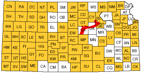
Several important cities and military bases are located in this area. Salina, the county seat of Saline County and largest city in the area, had a population of 24,001 in 1943; Abilene, the county seat of Dickinson County, had a population of 5,539; and Junction City, the county seat of Geary County, had a population of 9,524. Other cities and their 1943 populations include Milford (258) in Geary County; Chapman (873), Enterprise (706), and Solomon (811) in Dickinson County; and New Cambria (132) and Assaria (211) in Saline County. Milford is in Republican Valley; the other cities are in Smoky Hill Valley. The southern part of the Fort Riley Military Reservation is in Republican and Kansas Valleys north and east of Junction City. The reservation, which was established in 1852, comprises 22,000 acres and includes Fort Riley, one of the nation's large army posts and site of the Cavalry School, Camp Funston, Camp Whitside, and Marshall Flying Field. Two military bases were constructed southwest of Salina in 1942. Smoky Hill Army Air Field, comprising 2.5 square miles, is in Smoky Hill Valley 2 miles southwest of Salina. Camp Phillips, an infantry training base, covers a roughly triangular area of 70 square miles in southwestern Saline County. The cantonment at Camp Phillips is in the northeastern part of the camp area about 5 miles southwest of Salina.
Transportation facilities in the Smoky Hill Valley area are excellent. The main line of the Union Pacific Railroad from Kansas City to Denver follows Smoky Hill Valley between Junction City and Salina. Branch lines of the Union Pacific Railroad run from Junction City to Concordia, from Solomon to Beloit, from Salina to Colby, and from Salina to McPherson. A branch line of the Rock Island Railroad follows Smoky Hill Valley from Salina to Enterprise, where it turns south and joins the main line at Herington in southeastern Dickinson County. A branch of the Atchison, Topeka, and Santa Fe Railway that leaves the main line at Neva in northern Chase County enters this area at Enterprise and follows the Smoky Hill Valley to Abilene, thence turning north to Manchester, where it splits-one branch running north to Superior, Nebraska, and one northwest to Osborne, Kansas. The main line of the Missouri Pacific Railroad between St. Louis and Pueblo passes through the southeastern part of Saline County. A branch line of the Missouri Pacific leaves the main line at Gypsum in southeastern Saline County, passes through Salina, and rejoins the main line at Marquette in northwestern McPherson County.
Federal and State highways connect the Smoky Hill Valley area with all parts of the state. U. S. Highway 40, a main east-west highway, passes through all the towns in the valley between Junction City and Salina. The area is traversed by north-south highways U. S. 77 at Junction City, Kan., 43 at Enterprise, Kan., 15 at Abilene, and U. S. 81 at Salina. In addition to the Federal and State highways there are many county roads that are graveled and kept in excellent condition throughout the year.
Agriculture is the dominant industry in the Smoky Hill Valley area. The principal crops grown in the valley proper are wheat, corn, alfalfa, kaffir corn, and sorghum. Watermelons, cantaloupes, and some truck crops are grown in the sand-hills area that borders the north side of Smoky Hill Valley between Solomon and Abilene. Cattle raising is an important phase of the agriculture on the rough uplands that border the valley, particularly in the eastern part of the area. The urban industries are primarily related to the agriculture and particularly to wheat production. These industries include flour milling, wheat storage, and the distribution of farm machinery and supplies. Salina, the chief distribution center in north-central Kansas, has five large mills and ranks fourth in the nation in the production of flour. Abilene and Junction City also have flour mills, and every town in the area, regardless of size, has one or more wheat elevators.
Previous Investigations
No investigations dealing primarily with the geology and ground-water resources of Smoky Hill Valley in the central Kansas area, have been made previously. Brief references to the geology or ground water of parts of this area have been made in numerous reports, however. The more important of these are cited below.
In a report published in 1883 describing the geology of Kansas, St. John (1883, p. 591) included a description of brine wells of the National Solar Salt Company near Solomon. In a report on the physiography of western Kansas, Haworth (1897, pp. 35-41) includes brief physiographic descriptions of Smoky Hill, Saline, Solomon, and Republican Valleys. The brine wells near Solomon were again referred to by Bailey (pp. 72, 74-76) in 1902. In this same report, (p. 319) Bailey gave a brief discussion of the quality of the water from Sand Springs, the source of Abilene's water supply. Analyses of samples of water from wells at Salina, Chapman, Enterprise, Solomon, and Junction City and river samples from Smoky Hill River at Lindsborg and Republican River at Junction City were tabulated in 1911 by Parker (pp. 78, 96, 178, 217, and 233).
During the first World War, Moore (1918, pp. 39-81) published a popular description of the geology and physiography of the area about Camp Funston for the use of the soldiers in training there. A general discussion of ground-water conditions in the Camp Funston area and a description of the water supply at the camp are included in the report (pp. 57, 58, 76-78). Another report by Moore (1940) describes the ground-water resources of Kansas. In 1941 Jewett's excellent report on the geology of Riley and Geary Counties was published. Although emphasis was placed on the bedrock geology of this area, brief descriptions were given of the alluvial deposits in Republican and Smoky Hill Valleys and of the water resources of the area (Jewett, 1941, pp. 96, 112-115).
A report published in 1942 on the availability of ground-water supplies for national defense industries in Kansas includes descriptions of the availability of ground-water supplies in Smoky Hill, Saline, Solomon, and Republican Valleys (Lohman et al., 1942, pp. 31-35, 45, 46).
Acknowledgments
Thanks and appreciation are expressed to the many residents of the Smoky Hill Valley area who kindly supplied information regarding ground-water conditions in this area. Special acknowledgment is due the officials of the many cities who willingly furnished information about their respective city water supplies. I also wish to acknowledge the help and information received from the Quartermaster Corps, U. S. Army, at Fort Riley and the Corps of Engineers at Camp Phillips. The Layne-Western Company; Paulette and Wilson, Engineers; and the Widmer Engineering Company furnished many well records, well and test-hole logs, and water-level measurements which have been invaluable in this study.
The manuscript for this report has been reviewed critically by several members of the Federal Geological Survey and the State Geological Survey of Kansas; George S. Knapp and Robert Smrha of the Division of Water Resources, Kansas State Board of Agriculture; and Dwight Metzler and Ogden S. Jones of the Division of Sanitation, Kansas State Board of Health. The manuscript was edited by Betty Hagerman and the illustrations were drafted in final form by Woodrow W. Wilson.
Climate
The climate of the Smoky Hill Valley area is of the subhumid type and is marked by extremes of precipitation and temperature. The normal mean annual temperature at Salina, Chapman, and Junction City is 55.9° F., 55.4° F., and 55.3° F., respectively. The highest temperatures occur during the three summer months, the monthly mean being about 74° F. in June; 80° F. in July; and 78° F. in August. December, January, and February are generally the coldest months, the mean monthly temperature being about 32° F. in December; 29° F. in January; and 32° F. in February.
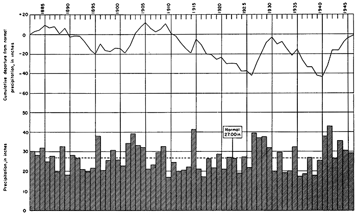
Figure 2--Annual precipitation and cumulative departure from normal precipitation at Salina.
The average growing season in the western part of the area is about 175 days, and has ranged from about 140 to about 200 days. In the eastern part of the area the average growing season is about 185 days and has ranged from about 160 to about 207 days.
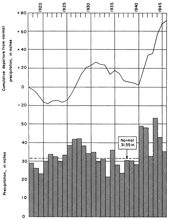
Records of the U. S. Weather Bureau show that the normal annual precipitation increases from west to east in this area. The normal annual precipitation at Salina is 27.00 inches, at Chapman it is 29.22 inches, and at Junction City it is 31.55 inches. Deviations from the normal are frequent, however. At Salina the recorded annual precipitation has ranged from a minimum of 16.89 inches in 1910 to a maximum of 43.19 inches in 1942; at Chapman it has ranged from 18.93 inches in 1917 to 47.13 inches in 1944; and at Junction City it has ranged from 21.56 inches in 1934 to 53.28 inches in 1944. The annual precipitation and the cumulative departure from normal precipitation at Salina, Chapman, and Junction City are shown graphically in Figures 2, 3, and 4.
Figure 3--Annual precipitation and cumulative departure from normal precipitation at Chapman.
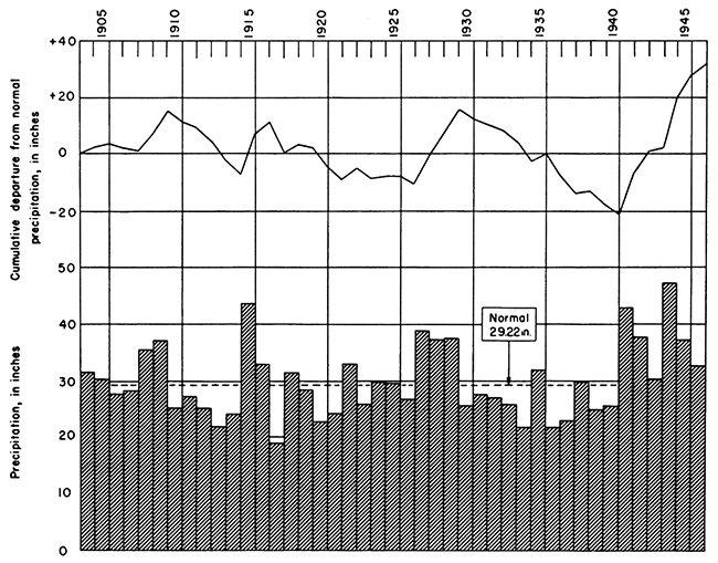
Figure 4--Annual precipitation and cumulative departure from normal precipitation at Junction City.
Prev Page--Contents || Next Page--Physiography
Kansas Geological Survey, Geology
Placed on web Nov. 13, 2013; originally published October 1949.
Comments to webadmin@kgs.ku.edu
The URL for this page is http://www.kgs.ku.edu/Publications/Bulletins/84/02_intro.html