![]()
Prev Page--Geologic Formations--Cretaceous || Next Page--Geologic History
Geologic Formations and Their Water-bearing Properties, cont.
Quaternary System
Pleistocene Series
McPherson formation
The McPherson formation as redefined in this report includes all the unconsolidated stream and slope deposits of Pleistocene age which occur in this area in the McPherson Valley and in the Arkansas River valley. It includes all the Emma Creek formation at the type locality and much of the loess of Lohman and Frye (1940). In general, the formation consists of early Pleistocene stream deposits, later and coarser Pleistocene stream channel deposits, and still later Pleistocene silt, clay, and fine sand deposited by sluggish streams and by slope processes as the McPherson Valley became filled after diversion of the major stream.
[Note--McPherson Valley is a physiographic term indicating the broad, north-south trending central area in McPherson and northern Harvey counties, which has an elevation lower than the bordering areas underlain by Permian and Cretaceous rocks. The term McPherson channel is used to describe the deeply buried, stream-cut channel incised in the older deposits in the western part of the McPherson Valley. McPherson formation is the formation name applied to the earth materials with which the McPherson buried channel is filled, and to older and younger Pleistocene stream and slope deposits which extend eastward from the channel in the McPherson Valley.]
Character and thickness.--The materials comprising the McPherson formation were deposited by streams and by slope processes operative throughout much of the Pleistocene Epoch, and the deposits vary greatly in physical character. The general character and thickness of the McPherson are shown on Plate 6 and in many of the logs of test holes and wells.
Locally a conglomeratic bed occurs at the base of the older part of the McPherson formation. It ranges from 1 to 6 feet in thickness and is composed of shale, quartz, and sandstone pebbles in varying proportions, cemented with impure calcium carbonate. In many places the lowermost beds of the McPherson are composed of unconsolidated tan to gray silt and clay, derived largely from the Wellington formation. The material in the conglomerate is similar to materials comprising the so-called Abilene conglomerate, a good exposure of which is located near the NW cor. sec. 30, T. 18 S., R. 2 E., just east of the mapped area. It is believed that at various outcrops the beds which have been called the Abilene conglomerate may represent different ages; hence the "Abilene" may not have much stratigraphic significance. The conglomerate at the base of the McPherson in this area, however, may be equivalent to some exposures of the "Abilene conglomerate" in Dickinson County.
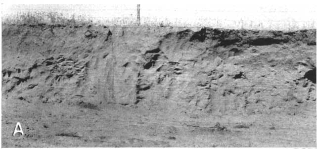
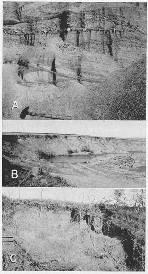
The older part of the McPherson formation, east of the McPherson channel contains much tan to buff silt, clay, and very fine grained sand in which are many irregular nodules of calcium carbonate. This silt is exposed along U.S. Highway 81 in T. 18 S., R. 3 W. and has been considered to be loess of considerably younger age (Lohman and Frye, 1940, fig. 2). Sand and some gravel occur in the older part of the McPherson formation (Pl. 8A). Locally, as near Moundridge, this material is exploited for road and building purposes; it is composed mostly of fine to course sand but contains some fine to coarse gravel. Test drilling indicates the maximum thickness of this material to be about 60 feet.
Plate 8A--Deposits of the McPherson formation in NE sec. 34, T. 27. S., R. 4 W. Photograph by C. C. William.
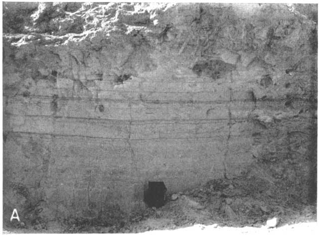
Volcanic ash occurs locally in the McPherson formation, generally near the base of the silt. The ash is exposed in the northern part of the area, especially in T. 18 S., R. 3 W., and T. 18 S., R. 4 W. Fourteen localities at which ash is exposed and which were examined during this study are designated by A on Plate 1. At several of these localities the ash has been exploited to some extent; ash was being hauled from one of the pits intermittently during the summer of 1944. Several years ago J. A. Schriner, Windom, Kansas, prepared and packaged volcanic ash from a pit, now covered, near the SE cor. sec. 28, T. 18 S., R. 5 W. The product was called Hurricane cleaner. [Note: The labels on the cans of cleaner pictorially likened its action to that of a tornado, sweeping all in its path before it. Marketing problems plagued the venture and the product never became widely known.] The ash is light gray to bluish gray where purest and is yellowish to buff where silt is admixed. It is generally from 1 to 2 feet thick; but the maximum known thickness of volcanic ash, or "silica" as it is known locally, is about 9 feet in sec. 20, T. 18 S., R. 3 W., near the exposure shown in Plate 15A.
Plate 15A--Volcanic ash in McPherson County. Pit in the NW sec. 20, T. 18 S., R. 3 W.; note bedding. Photograph by C. C. Williams.
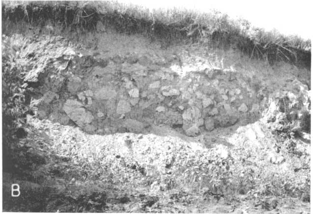
The presence of ash in McPherson County was noted by Udden (1891, p. 340-345); and by Haworth and Beede (1897, p. 289) who described it as occurring within a clay layer and as being from 18 to 24 inches thick. Landes (1928, p. 30-32) described ash deposits from four localities in McPherson County and inferred from one that the ash was younger than the channel gravels of the McPherson formation. Although some reworked ash does occur in the channel deposits of the McPherson, the original ash occurs in the older deposits of the McPherson formation. Boulders of volcanic ash in channel gravel deposits of the McPherson (Pl. 15B) and other deposits elsewhere indicate the older age of the ash. Lohman and Frye (1940, p. 853) described the ash as occupying a stratigraphic interval at or near the base of the loess. In the area of volcanic ash outcrop the material formerly mapped as loess is now believed to be a bed of silt in the McPherson formation. In the vicinity of McPherson, however, the "loess" is much younger, does not occupy the same stratigraphic interval as the older silt, and is included in the upper part of the McPherson formation.
Plate 15b--Volcanic ash in McPherson County. Blocks of volcanic ash included in a deposit of sand and gravel of the McPherson formation in the SW sec. 9, T. 17 S., R. 5 W. Photograph by C. C. Williams.
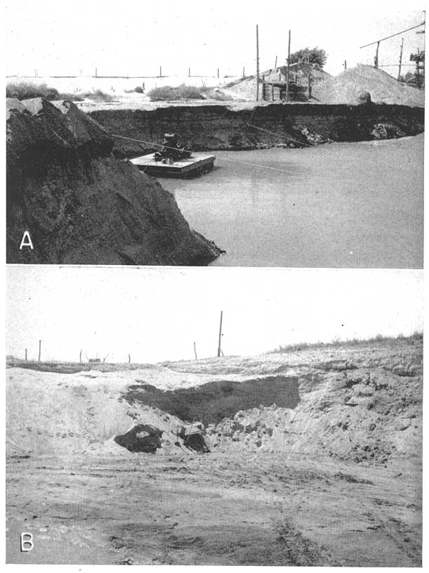
The stream deposits filling the deeper channel through the McPherson Valley, here called the McPherson channel, are younger than the finer stream deposits of the McPherson formation occurring east of the channel. The channel deposits consist of sand and gravel in the lower part (Pl. 16) and silt and sand above. The coarser material ranges from medium sand to coarse gravel. The grains and pebbles of sand and gravel are composed mostly of quartz, but many are fragments of pink and white feldspar and other igneous rocks. Some pebbles are composed of blue and olive-green chert; some caliche and nodules of calcium carbonate occur in the gravel. Haworth and Beede (1897, p. 29) state that the samples of the sands and gravels of the McPherson Equus beds studied by them contained no feldspar. Lohman and Frye (1940, p. 852), and Frye and Hibbard (1941, p. 268) state that the McPherson formation contains grains of pink and red quartzite similar to that which occurs typically as erratics in the glaciated area of northeastern Kansas. During preparation of this report samples from many test holes and gravel pits were examined microscopically in the laboratory and fragments of pink and red quartzite were not observed, although pink and red feldspar is common in the samples.
Plate 16--A, Gravel pit in the McPherson formation at the NW cor. sec. 13, T. 25 S., R. 2 W. B,Sand pit in channel deposits of McPherson formation in the SW SW sec. 31, T. 18 S., R. 4 W. Floor of pit is Ninnescah shale. Photograph A by S. W. Lohman; B, by J. C. Frye.
The silt interbedded with and above the sand and gravel of the channel deposits is tan to buff and contains some nodules of calcium carbonate. Locally thin beds of volcanic ash, believed to be reworked from older ash deposits, occur in the channel deposits. Near the top of the McPherson formation the silt is brown.
Test drilling northwest of McPherson indicates that the maximum thickness of the McPherson formation is about 260 feet in the deepest part of the channel penetrated (Pl. 6). These deposits thin to a featheredge westward along the outcrop of the Ninnescah shale. Eastward from the McPherson channel the coarse sand and gravel become thinner, and brown and tan silt overlies the clastic deposits.
Origin.--Haworth and Beede (1897, p. 290-295) after noting and objecting to several possible hypotheses for the origin of the McPherson formation, concluded (p. 295): "At present it must be admitted that no satisfactory explanation of the origin of the Equus beds channel, nor the agency for the deposition of the materials, has been advanced."
One of the objections noted by these authors was that the comparative altitudes of the drainage divide near McPherson and the present Smoky Hill River between Marquette and Lindsborg were not in accord with any hypothesis postulating a southward course for Smoky Hill River, especially since no terrace deposits were known to occur along Smoky Hill River.
Frye (1939, p. 1,232-1,233) postulated an eolian origin for the thick deposits of silt underlying the area of the drainage divide near McPherson. Still assuming that no terraces existed upstream along the Smoky Hill to allow a much higher former altitude for that stream, the eolian silt hypothesis was advanced to permit logically the southward course of Smoky Hill River during McPherson time.
In 1940 Lohman and Frye observed (p. 846): "At the close of Emma Creek [early McPherson] sedimentation there appears to have been a through valley or depression extending south from a point near Lindsborg past McPherson to the Arkansas Valley, and this valley may have contained a through-flowing stream. At this time the Kansan glacier dammed the Kansas River northeast of the area. When this glacier began to melt, excessive quantities of melt water filled the Smoky Hill Valley and found an outlet through the 'McPherson Valley,' ultimately joining the ancestral Arkansas Valley. The glacial outwash carried by this stream was deposited to form the McPherson formation (restricted)."
It is believed that direct relationship between the deposits of the McPherson formation and outwash from the glacier of the Kansan Stage should not be postulated because of the considerable difference in altitude between the McPherson formation and the glacial deposits. It is believed that the origin of the McPherson is more closely related to the later glaciation in the Rocky Mountains; at least, no grains or pebbles of rock similar to those comprising the glacial erratics in northern and northeastern Kansas were found in samples of the McPherson formation.
Terrace deposits were described by Frye, Leonard, and Hibbard (1943, p. 33-37) along the Smoky Hill River in Ellsworth and Russell counties just west of this area. It was pointed out by them that the discovery of the terraces removed objections advanced by Haworth and Beede, although the silt near McPherson was still considered to be of eolian origin. Since recognition of the terraces, the hypothesis of eolian origin of the silt seems no longer necessary.
The channel sands and gravels of the McPherson formation seem to have been deposited by streams flowing southward through the McPherson Valley. The principal stream may have flowed southward following the direction of the present channel of Smoky Hill River but at a much higher level from Salina to Lindsborg, and it may have continued in a direction slightly west of south past McPherson, Inman, and Buhler toward and across the present Arkansas River north of Colwich (Pl. 7). A large tributary stream occupied the course of Smoky Hill River above Marquette at the higher level, indicated by the terrace deposits there, entered the area from the northwest, and joined the main stream northwest of McPherson. These streams cut the channel and deposited the sand and gravel of the McPherson formation. It is believed that capture of the principal stream near Salina directed drainage eastward, and that after this capture and reversal of drainage some of the silt in the upper part of the McPherson was deposited by overflow during periods of flood and by filling of low areas with silt-laden water from the sides of the McPherson Valley. Some of the silt washed thusly into the valley from the sides probably was redeposited on hills and in valleys as dust from the southwest and later redeposited in the lower areas by rain wash and by other processes. The valley sides were reduced in steepness by erosion and the fine materials were deposited in the valley through which no stream was then flowing. Further local development of low areas by solution, the process which probably was responsible for the original course of the stream, continued and the resulting sinks served as traps for silt-laden water, the runoff from higher land. Some deposits of reworked volcanic ash resulted from these same processes.
The sand and gravel was derived from Cretaceous sandstones, from the Ogallala formation, from earlier Pleistocene deposits, and from igneous rocks in the Rocky Mountain area. The silt was derived from weathered shale of Cretaceous and Permian age and from the reworking of eolian silt probably transported to the area from the southwest.
The McPherson formation in the present Arkansas River valley was deposited by a stream entering the southern part of the area from the northwest. This stream, which was a tributary to the stream system flowing southward through the McPherson Valley, occupied approximately the same position as the present Arkansas River (Williams, 1946). Toward the close of this period, the ancestral Arkansas River flowed at a level somewhat higher than the present Arkansas River, having filled a deeply excavated channel approximately equivalent in depth and age to the McPherson channel farther north.
Most of the sediments comprising the older part of the McPherson formation, into which the McPherson channel was cut, were deposited by streams flowing southward through the McPherson Valley. Streams contributing to deposition in early McPherson time entered the area from the north, northeast, and northwest, occupying positions near the present Smoky Hill River near Marquette from the northwest and near Smoky Hill River from Lindsborg to Salina from the north. Other smaller streams entered from the east and northeast. This is a comparable drainage pattern to the one that existed during deposition of the channel deposits of the McPherson except that streams were flowing at a higher level in the early part of McPherson time, the principal streams were from the north, and the main channels were east of the later and deeper McPherson channel, as indicated by gravel deposits near Moundridge and elsewhere. Tributary drainage from the east and northeast deposited silt derived from Permian and Cretaceous shale and larger fragments and pebbles forming the zone of conglomerate. The streams were nearly at grade and much silt was deposited on floodplains.
The volcanic ash was derived from the southwest (Landes, 1928, p. 17-19) and was transported to the area by wind before the channel deposits of the McPherson were laid down. The ash was deposited originally in valleys, depressions, and on leeward slopes. Some of the ash may have remained as first deposited, but most of it was transported from its original location downslope by water running in small streams and rivulets and redeposited elsewhere. The character of the ash shown in Plate 15A indicates redeposition. Undoubtedly some of the silt included in the McPherson formation was transported to and redeposited in the area in a similar manner.
Distribution and surface form.--The distribution of the McPherson formation is shown on Plate 1. The McPherson underlies most of the central part of this area from Smoky Hill River to the south border, and is known to occur southward along the Arkansas River nearly to the southern boundary of Kansas.
The surface of the area underlain by the McPherson formation is generally flat or gently rolling. Extreme flatness characterizes the areas near McPherson and in the Arkansas Valley plain. The surface becomes increasingly dissected northward from McPherson toward the Smoky Hill River, owing to erosion in Recent time. The buried McPherson channel is marked by a linear succession of depressional areas (Pl. 1).
Age and correlation.--As shown by Hibbard (1948), the vertebrate fossils collected from the McPherson formation range in age from early to late Pleistocene. However, it seems inadvisable at present to assign any part of the McPherson to any particular stage of the Pleistocene as known in the upper Mississippi Valley. Part of the McPherson formation is equivalent in age to part of the Meade formation in southwestern Kansas, and the volcanic ash in the lower part of the McPherson is equivalent to Cragin's Pearlette ash in Meade County.
Discussion of age and correlation.--Certain beds named the Emma Creek formation by Lohman and Frye (1940, p. 849-851) were later described in detail by Frye and Hibbard (1941). In defining the formation Lohman and Frye state (p. 849): "The term McPherson Equus beds was used by previous investigators to include all of the unconsolidated deposits in Harvey and McPherson counties, and all of these beds were held to be of Pleistocene age. The present investigation has revealed, however, that although a part of these deposits is Pleistocene in age, a large part appears to be Pliocene in age. It is here proposed to remove the Pliocene beds from the McPherson Equus beds of Haworth and Beede and assign to them the name Emma Creek formation - from exposures along Emma Creek in southeastern McPherson County. The McPherson formation (restricted) is retained to include only the fluvial deposits of Pleistocene age."
The present definition of the McPherson formation includes most of the Emma Creek formation of Lohman and Frye (1940) and the name Emma Creek formation is eliminated as a stratigraphic term for the following reasons: (1) In the original description, deposits comprising the Emma Creek formation in the type area were placed in the same formation with unrelated Pliocene deposits in the northern part of the area, discussed above, and the entire formation was assigned to the Pliocene. Identification of fossils collected from the sediments in the type area, together with observed stratigraphic position, now indicate the Pleistocene age of the type Emma Creek. (2) Several of the exposures correlated with the Emma Creek and figured (Frye and Hibbard, 1941) as illustrating typical lithologic facies of the Emma Creek formation are now known to represent other sediments. The "pit in the gravel or channel phase of the Emma Creek SW 1/2 SE sec. 12, T. 18 S., R. 5 W." (Frye and Hibbard, 1941, p. 266, fig. 2) is a pit in the channel gravels of the McPherson formation from which typical McPherson fossils have been collected (Hibbard, 1948). The correct legal description of this pit is SE SW sec. 12, T. 18 S., R. 5 W. The "'Mortar bed' phase of the Emma Creek formation" (Frye and Hibbard, 1941, p. 267, fig. 3) is here correlated with similar deposits near by which contain fossils of Pleistocene age. The volcanic ash shown (1941, p. 271, fig. 6) and described as unconformably overlying deposits of the Emma Creek formation, and earlier considered as occurring at the base of the "loess" above the McPherson formation (restricted) (Lohman and Frye, 1940, p. 853), occupies a stratigraphic position which shows that it is older than the McPherson formation as restricted by Lohman and Frye, and to comprise part of the older deposits of the McPherson. Thus, the ash comprises part of the original Emma Creek formation of Lohman and Frye. The volcanic ash is shown by paleontologic evidence (Hibbard, 1948) to be of Pleistocene age, equivalent to Cragin's Pearlette ash of Meade County. (3) Differences in lithology were listed as being diagnostic in the differentiation between the McPherson formation (restricted) and the Emma Creek formation. Lohman and Frye (1940, p. 849) state: "The sands and gravels of the Emma Creek were derived from the Cretaceous and Permian rocks adjacent to the north and east. They consist largely of quartz grains but also contain many grains and pebbles of the harder sandstones and concretions of the Dakota group, pebbles and cobbles of Permian chert, and of Cretaceous and Permian shale. The McPherson formation (restricted) comprises glacial outwash and contains grains of feldspar, acid and basic igneous rocks, and red quartzite, whereas none of these constituents is found in the Emma Creek formation."
Later (Frye and Hibbard, 1941, p. 267) this description was amplified to include: "The 'Mortar-beds' phase [of the Emma Creek formation], and related beds, on the other hand, contain a considerable percentage of granite pebbles and other western rock types."
While studying many samples of cuttings from test holes and wells, it was noted that although the percentage is somewhat less than in other deposits, the pebbles of igneous rocks typical of the Rocky Mountain area are common in and form a considerable part of the sand and gravel in the older part of the McPherson formation, and that the channel deposits of the McPherson formation as restricted by Lohman and Frye contain most of the rock types listed as distinguishing the Emma Creek, although in different proportions.
Thus it seems that the deposits of the Emma Creek formation (excluding Pliocene deposits here placed in the Delmore formation) should be included in the McPherson formation. Indeed, the Emma Creek comprises part of the McPherson formation (restricted) because it is Pleistocene in age, is a stream deposit, and because it is lithologically indistinguishable from beds of the McPherson. A small area in the northern part of McPherson County several miles from the type locality of the Emma Creek is underlain by deposits of Pliocene age. These deposits comprise the Delmore formation described above.
Water supply.--The McPherson formation comprises the principal source of ground water in this area. The quantity of water that may be derived from the McPherson formation is variable owing to differences in the thickness and physical character of the sand and gravel in the formation. Supplies of water adequate for domestic and stock uses are available to wells in most all the area underlain by the McPherson, and large supplies have been developed from this formation at the Hutchinson Naval Air Base, at Moundridge, and, in part, at the Newton well field. In the area underlain by the McPherson channel deposits, the McPherson formation contains beds of clean gravel and coarse sand that yield water freely. The public water supplies of McPherson, Inman, and Buhler are obtained from this part of the formation. One of the municipal wells at McPherson yields 1,400 gallons a minute and the other 2,000 gallons a minute, with drawdowns of 17 and 27 feet, respectively. In the eastern part of the area, not underlain by the channel deposits of the McPherson, the McPherson formation yields water in considerably smaller quantities. In the Arkansas River valley, the McPherson formation yields very large quantities of water to wells. The Wichita municipal water supply is derived from 25 large wells, most of which yield about 1,000 gallons a minute from the McPherson. Detailed description of this water-supply development is given below. The wells supplying water to Halstead and Newton penetrate the McPherson formation beneath Recent alluvium, and those cities obtain a part of their water supply from these deposits. The cities of Burrton and Hutchinson are supplied with water derived from the McPherson formation in the Arkansas River valley.
Many samples of water were collected from wells penetrating the McPherson formation, and analyses are given in Table 13. Variations in the quality of water are shown graphically on Figure 29. The chemical character of the water varies widely, but in general water in the McPherson is of comparatively good quality except in areas where saltwater has entered the formation from natural or industrial sources. Analyses 415 and I (Fig. 29) are representative of the quality of the uncontaminated ground water in the McPherson. The two samples contained 228 and 407 parts per million of dissolved solids, respectively, 129 and 320 parts of hardness, and 10 and 33 parts of chloride. Water represented by analysis 415 is about average for the new Wichita supply, which is treated before distribution. Water shown by analysis I is used by the City of McPherson without treatment. Analysis J shows the effect of contamination near one of the oil fields in the area. Some of the other analyses given in Table 13 show greater contamination by oil-field brines.
Water in the McPherson formation contains excessive amounts of carbon dioxide in some places, as at Buhler, which corrodes mains and pipes unless it is removed. At other places, as in part of the new Wichita well field, difficulty is experienced with deposition of iron compounds in well screens and pipes. The iron-depositing organisms (Crenothrix) are controlled in the Wichita well field by the introduction of chlorine.
Pleistocene and Recent Series
Dune sand
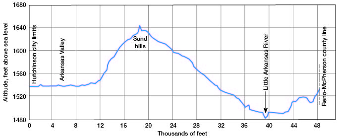
Distribution and surface form--Sand dunes extend over a wide belt northwestward from the Little Arkansas River northeast of Burrton in Harvey County to a point east of Saxman in Rice County. These sand dunes occupy the central part of the area included in this report (Pl. 1) and form the only prominent topographic relief in this part of the area (Fig. 9). The higher dunes (Pl. 17), near the center of the dune area, are subject to shifting by wind owing to the scanty cover of vegetation. Small ponds are common in the interdune areas during rainy seasons. Near the edge of the dune area the dunes are lower, more rounded, have a soil zone, and, in many places, have a cover of vegetation. The subdued dunes are subject to blowout in times of prolonged drought but are relatively more stable than the higher dunes.
Plate 17--Features of the sand-dune areas: A, B, Actively shifting sand, NE sec. 33, T. 22 S., R. 3 W. A light fall of snow accentuates the ripples. C, Shifting sand 5 miles northeast of Hutchinson. Photographs by J. C. Frye.
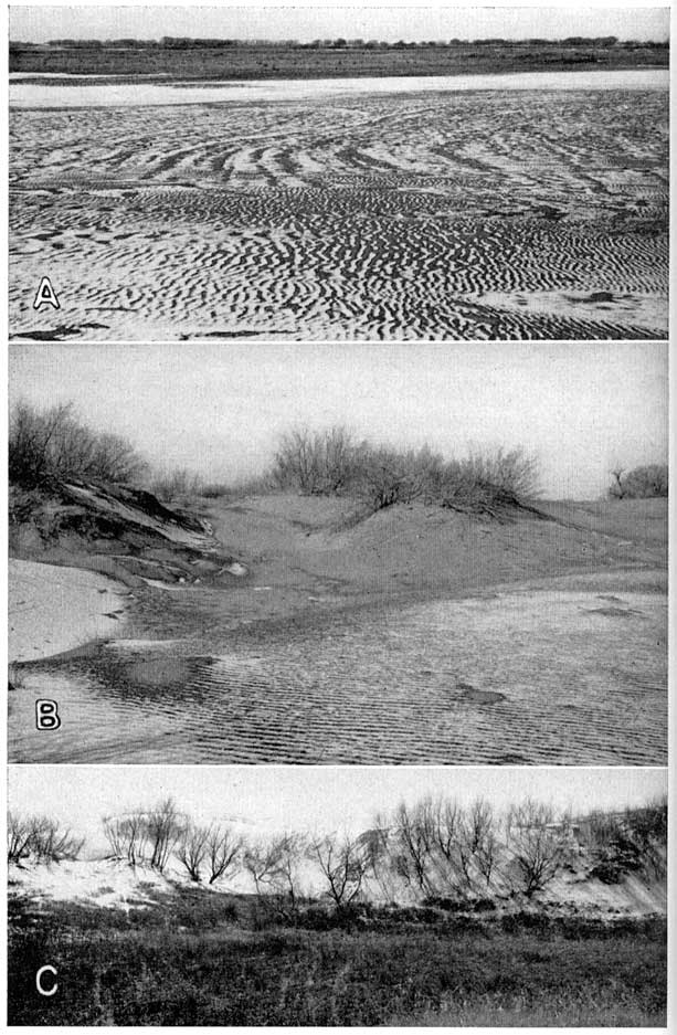
Figure 9--Profile of the surface of the sand dunes along Chicago, Rock Island, and pacific Railway from Hutchinson city limits to the Reno-McPherson County line.
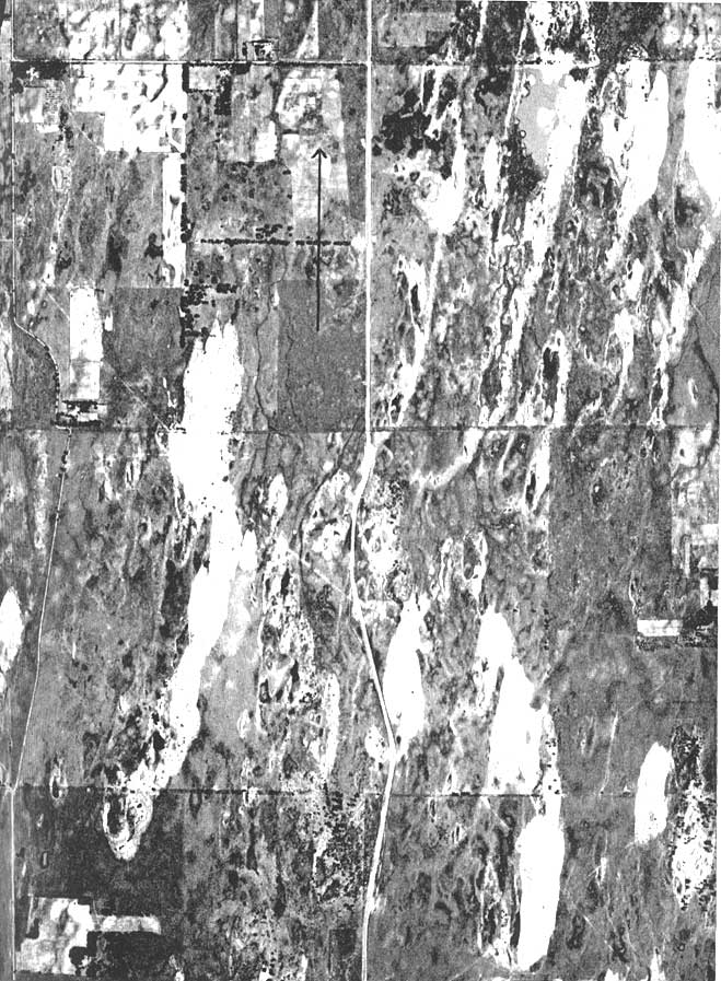
Character and thickness.--The material comprising the sand dunes consists mainly of fine- to medium-grained, well-rounded quartz sand. Silt, clay, and organic matter locally are admixed and intercalated, probably representing soil zones which developed on the dunes in quiescent periods and interdune pond areas which later became covered with drifting sand. The sand is believed to have been derived from the deposits in the Arkansas Valley and from older Pleistocene stream deposits southwest of this area. North of Hutchinson Smith (1938) found evidence, consisting primarily of buried soil zones and variations of bedding, that indicates at least three periods of rapid growth alternated with periods of quiescence. The longitudinal dunes shown in Plate 18 indicate the south-southwesterly direction of recent dune-forming winds. The maximum thickness of the dune sand in this area is about 150 feet.
Plate 18--Aerial photograph of sand dunes in the northwestern part of T. 23 S., R. 3 W., north of Burrton. Note interdune ponds. Arrow points north and is about 0.5 mile long. U.S. Department of Agriculture photograph.
Age.--The topographic position of the sand dunes north of Burrton and Hutchinson indicates that the dunes are older than the present valley of the Little Arkansas River and that they are younger than the filled McPherson channel. The dunes probably were built, for the most part, by winds blowing across the old floodplain of the Arkansas River after that stream had diminished in size near the close of the Pleistocene Epoch. The older sand dunes, then, are nearly equivalent in age to the younger part of the McPherson formation along the Arkansas River. The younger, higher sand dunes are of more recent formation, the sand being derived from older sand dunes nearby. There is some indication that the Little Arkansas River may have flowed south through the older sand dunes from Buhler toward Burrton. If this stream occupied this course, the shifting sand may have been the cause of the change in course and the younger sand dunes are as old as Little Arkansas River east of Buhler.
Water supply.--No large supplies of ground water have been developed in the area underlain by sand dunes. The sand hills area is range land, for the most part, and contains many stock wells yielding quantities of water sufficient for the needs of the cattle. Farms and orchards along the edge of the dune area are supplied with water for domestic, stock, and spraying purposes. The material comprising the dunes is relatively fine grained and probably will not yield large quantities of water to wells. The sand-dune area affords an excellent catchment area for rainfall, and much of the rain that falls on the porous sand enters the dunes and moves southwestward toward the deposits of the McPherson formation. The areas near the Newton municipal well field and the southern end of the Wichita municipal well field are underlain by subdued sand dunes, and considerably larger quantities of water can be pumped in these areas because of the good facilities for recharge.
Few samples of water were collected from wells in the sand dunes; ground water from this source is known to be comparatively soft but to contain undesirable quantities of iron (Williams, 1946). Large quantities of iron in the water are indicated by slimy deposits of precipitated iron oxide which border many of the small springs flowing from the dunes. The analysis of water from well 375 is shown graphically on Figure 29. Dissolved solids in this water were 224 parts per million, the total hardness was 102 parts, and iron was 1.2 parts.
Recent Series
Alluvium
Distribution, thickness, and character.--Alluvium of late Quaternary age occurs in the Arkansas River valley, Little Arkansas River valley, Smoky Hill River valley, and along Sand Creek, Emma Creek, and Turkey Creek. Little or no alluvium occurs in the Ninnescah River valley in this area. A small amount of alluvium occurs in the valley of Gypsum Creek but it is thin and is not shown on Plate 1. Some of the material currently being deposited in sinkholes and other depressional areas might well be classed as alluvium but is not differentiated from the upper part of the McPherson formation.
In the Arkansas River valley the alluvium is similar in character to the deposits of the McPherson formation and is derived largely from the McPherson. There is physical evidence of Recent deposition in the inner valley of the river, noted above, and fossils of Recent age have been collected from the alluvium and are discussed by Hibbard (1948). However, in subsurface study no division can be made between the alluvium and the McPherson formation by differences in lithology. It is convenient to treat the entire thickness of material underlying the floodplain of the Arkansas River as a unit, not only because of the similarity of the unconsolidated deposits, but also because of the similarity of the chemical quality of the ground water contained in these beds. The deposits comprising the alluvium of the Arkansas River are composed of unconsolidated gravel, sand, and silt (Pl. 19A). Some of the gravel is very coarse and large yields may be expected from properly constructed wells penetrating the coarse deposits. The maximum thickness of the alluvium probably is about 75 feet.
Plate 19--A, Cross-bedded sand and gravel in the alluvium of Arkansas River Valley exposed during excavation for the filtration plant in the City of Wichita. B, Sand pit in the McPherson formation in the SE SwW sec. 12, T. 18 S., R. 5 W. C, Thinly bedded silt in the alluvium of Little Arkansas River in the NW sec. 19, T. 24 S., R. 1 W. Photograph A by G. H. von Hein, B and C by J. C. Frye.
The alluvium of the Smoky Hill Valley is composed of silt, clay, sand, and gravel in varying proportions and in general this material is finer than the alluvium of the Arkansas Valley. The character of the material composing the alluvium is described in detail in several of the logs given at the end of this report.
Most of the alluvium in the area was derived from the McPherson formation and from Tertiary deposits nearby and westward, but some material in the alluvium probably was transported to its present position directly from the Rocky Mountains. Adjacent Cretaceous and Permian rocks have contributed much of the material composing the alluvium of the Smoky Hill Valley.
Water supply.--Very large supplies of water are available from the alluvium of the Arkansas Valley. The former Wichita public water supply was derived from wells tapping the alluvium in a small area near the junction of the Arkansas and Little Arkansas rivers, and this source of supply was abandoned, not because of scarcity of water, but because of the chemical character of the water. The results of the pumping test conducted at the Ripley Station of the Kansas Electric Power Company, discussed in detail below, indicate the permeable nature of the alluvial deposits of the Arkansas and Little Arkansas River valleys near Wichita. Wells in the City of Hutchinson derive large supplies of water from the alluvium of Arkansas River and the cities of Halstead (in part), Sedgwick, and Valley Center receive water from the alluvium of the Little Arkansas River. The cities of Lindsborg and Marquette are supplied with water from the alluvium of the Smoky Hill River valley.
The quality of the water in the alluvium of the Arkansas, Little Arkansas, and Smoky Hill rivers is different in each valley and varies from place to place within each valley, as shown on Figure 29. Ground water in the alluvium of the Arkansas River valley generally is hard and contains objectionable quantities of chloride. Analyses LLL and WWW (Fig. 29) show the hardness and chloride content of water in the alluvium of the Arkansas. Analysis WWW shows the chemical character of the water with which the City of Wichita was supplied prior to Sept. 1, 1940. In general, the ground water in the alluvium near the river is of poorer quality. Wells in the alluvium of the Little Arkansas River yield relatively hard water, but the water is not so highly mineralized as that in the alluvium of the Arkansas River; the water pumped by the cities of Halstead, Valley Center, and Sedgwick is not treated before use. The cities of Lindsborg and Marquette are supplied with hard water from the alluvium of the Smoky Hill River valley. At Lindsborg (analyses 4 and A) the water contains 706 parts per million of dissolved solids and has a total hardness of 456 parts. Iron occurs in the ground water in the alluvium of the Smoky Hill River and in some places renders the water undesirable.
Prev Page--Geologic Formations--Cretaceous || Next Page--Geologic History
Kansas Geological Survey, South-central Kansas
Comments to webadmin@kgs.ku.edu
Web version April 2005. Original publication date July 1949.
URL=http://www.kgs.ku.edu/Publications/Bulletins/79/07_geoquat.html