![]()
Prev Page--Geologic Formations || Next Page--Geologic Formations--Quaternary
Geologic Formations and Their Water-bearing Properties, cont.
Cretaceous System
Cragin (1886, 1889, 1895) classified the Cretaceous sediments of southern Kansas as the Cheyenne sandstone, the Kiowa shale, and the Dakota sandstone, named in ascending order. Prosser (1897) reviewed the history of geologic study of Lower Cretaceous rocks in Kansas and assigned the Cheyenne sandstone and Kiowa shale to the Comanchean Series. Later, Gould (1898) redefined the Kiowa and Dakota of southern Kansas and described the Medicine beds between the Kiowa shale and the Dakota sandstone. Darton (1920, p. 2) subdivided the Cretaceous rocks that lie below the Graneros shale in western Kansas into the Cheyenne sandstone, the Kiowa shale, and the Dakota sandstone. Twenhofel (1924, p. 12-34) classified the Cretaceous sediments in southern and central Kansas as Cheyenne sandstone, Belvidere formation, and "Dakota" formation, retaining the term Kiowa for the lower shale member of the revived Belvidere formation. Bass (1926, p. 59, 73-76) used the term Dakota sandstone for all sediments between the Permian red beds and the Graneros shale, recognizing that part of these sediments probably were equivalent to the Purgatoire formation of eastern Colorado. Elias (1931, p. 28) classified equivalent sediments in western Kansas as the Dakota group, and Tester (1931, p. 234-283) applied the name Dakota Stage to the succession of strata occupying the interval between the Graneros shale and Pennsylvanian sediments at the type locality of the Dakota in northeastern Nebraska. Latta (1946) discussed in detail the stratigraphy and history of classification of the Comanchean rocks in Kansas.
The term Dakota group has been used by the State Geological survey of Kansas (Moore and Landes, 1937; Moore, 1940, p. 40) to include all Cretaceous strata that lie below the Graneros shale. The beds formerly included in the Dakota group were studied in their outcrop area in central and north-central Kansas (although not in McPherson or Marion County) by Plummer and Romary (1942), and the terms Cheyenne sandstone, Kiowa shale, and Dakota formation were adopted to include all Cretaceous strata that lie below the Graneros shale. Subsequent reports of the State Geological Survey of Kansas (McLaughlin, 1943; Frye and Brazil, 1943; Swineford and Williams, 1945; and Latta, 1944, 1946) have followed this classification, and it is the one used in this report. Of the above closely related Cretaceous formations, only the Kiowa shale is believed to be represented by the Cretaceous rocks of this area.
Kiowa shale
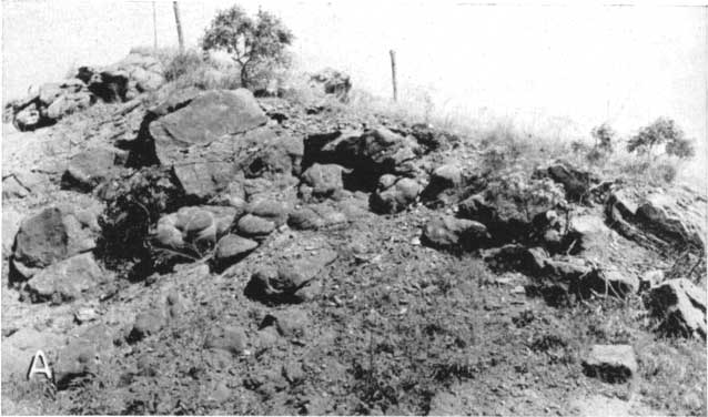
Character and thickness.--Included in the Kiowa shale in this area are the fossiliferous sandstones and shales comprising the Mentor formation of Cragin (1895, p. 162) and the Belvidere formation of Twenhofel (1924, p. 31-34). In this area the Kiowa shale is composed of marine, nonmarine, hard, and soft sandstones, variegated and fissile shales, and some thin coquinoid limestones or shell beds. These beds are well exposed along ravines and canyons in sec. 5, T. 18 S., R. 5 W. (Pl. 11B). A section measured and published by Twenhofel (1924, p. 32) is characteristic of the Kiowa in this area and is included here.
Plate 11--Cretaceous rocks in McPherson and Marion counties: A, "Quartzite" near the SW cor. sec. 24, T. 17 S., R. 2 W., showing concretionary form. B, Sandstone and sandy shale in the Kiowa shale in the NE sec. 5, T. 18 S., R. 5 W. The capping sandstone contains "Mentor" fossils. C, Slumping small terrace is shown in foreground. Photographs A and C by C. C. Williams; B by B. F. Latta.
| Section at the Natural Corral, McPherson County, NW sec. 5, T. 18 S., R. 5 W. (Twenhofel, 1924, p. 32) | Thickness, feet | |
|---|---|---|
| 12. | Covered slope with Tertiary at the top, but float indicates the presence of red sandstone of the "Dakota." | 50 |
| 11. | Cross-laminated, highly ferruginous and concretionary coarse red sandstone. The concretions similar to those characteristics of the "Dakota." About 4 to 6 feet from the top is a horizon containing the typical Mentor fauna. Fossils may be present in other parts of this zone but they have not been observed. There are many places in the immediate vicinity where the zone appears to contain no fossils whatever. This in part may be due to original absence, but in some cases it appears probable that it is due to the development of limonite concretionary structures whose presence in places has so completely modified the rock that all original features have been obliterated. This zone forms the rim of the canyon and the shoulders of the bluffs in the immediate vicinity. | 8 |
| 10. | Cross-laminated, medium-grained, friable yellow sandstone; no fossils. | 2 |
| 9. | Friable, fine-grained, yellowish sandstone with a somewhat compact 6-inch band near the middle and another similar 2-inch band about 7 feet from the top. Locally the zone contains a little shale. It forms the upper portion of the cliff above the spring at the head of the east arm of the corral, where it is thinner and more compact than indicated above. No fossils. | 17.5 |
| 8. | Compact yellowish-white sandstone; no fossils. | 7-8 |
| 7. | Blue paper shale; no observed fossils. | 10 |
| 6. | Pale yellow sandstone, containing dicotyledonous leaves. | 2 |
| 5. | Blue gypsiferous shale. | 14 |
| 4. | Two 6-inch layers of gray shell limestone separated by gray shale. The limestone consists almost wholly of shells. The most common species being Ostrea kiowana, Cyprimeria kiowana, Cardium kansasensis, and Turritella seriatim-granulata belviderii. | 3 |
| 3. | Dark-blue gypsiferous shale containing many crystals of yellow selenite, nodules of pyrite and a layer of cone-in-cone limestone. The cone-in-cone layer, or one very similar, has been found in a number of localities in Saline and McPherson counties where no fossiliferous strata are present. | 16 |
| 2. | Concealed, believed to be shale and sandstone | 14 |
| 1. | Permian. Red, blue and yellow shales of the Wellington formation | 25 |
A section of rocks measured by Plummer and Romary (1942, p. 323) indicates the nature of similar rocks at Kanopolis dam site along the Smoky Hill River. A section of the Kiowa shale along the east bank of a small tributary to the Cottonwood River in the northeastern part of the area (Pl. 8B) showing the basal contact with the Wellington formation follows.
Plate 8B--Kiowa shale unconformably overlying shale of the Wellington formation in NW sec. 32, T. 18 S., R. 1 E. Photograph by C. C. Williams.
| Section of the Kiowa shale in NW sec. 17, T. 18 S., R. 1 E. | Thickness, feet | |||
|---|---|---|---|---|
| Cretaceous--Comanchean | ||||
| Kiowa shale | ||||
| 4. Sandstone, thin, buff to tan, and sandy shale; contains fragments of plant remains | 9 | |||
| 3. Shale, light buff, sandy; a few thin sandstone beds intercalated; some selenite crystals on exposed surface | 7 | |||
| 2. Clay shale, black and dark blue, paper thin, soft; contains much gypsum; selenite crystals abundant on exposed surface | 9 | |||
| Permian--Leonardian | ||||
| Wellington formation | ||||
| 1. Shale, hard, gray, green, and maroon; contains a few thin siltstones. Upper 1 foot composed of reworked and redeposited consolidated shale conglomerate derived from the Wellington and marks the unconformable contact | 8 | |||
| Total thickness exposed | 33 | |||
Beds 2, 3, and 4 in this section are approximately equivalent to beds 3 to 8 in Twenhofel's section given above.
The basal contact of the Kiowa shale with rocks of Permian age, where exposed, is in many places distinguished by the presence of a clastic deposit of either reworked Permian shale or a thin zone (1 to 2 feet thick) containing large, well-rounded pebbles and cobbles up to 3 inches in diameter composed of chert or resistant igneous rock. An exposure of this zone above the Ninnescah shale, in the SW 1/4 sec. 2, T. 17 S., R. 5 W., is shown in Plate 12A. This zone is not confined to the Permian-Kiowa contact but occurs rather persistently at the base of the Cretaceous section in Kansas, whatever the overlying rock may be. Plummer and Romary (1942, p. 320) note the occurrence of a similar pebble zone at the base of the Dakota formation in Clay County, and Latta (1946) has observed a similar zone at the base of the Cheyenne sandstone in Kiowa County.
Plate 12A--Zone containing pebbles and cobbles of resistant rocks at the contact between the Ninnescah shale and Kiowa shale. Photograph by B. F. Latta.
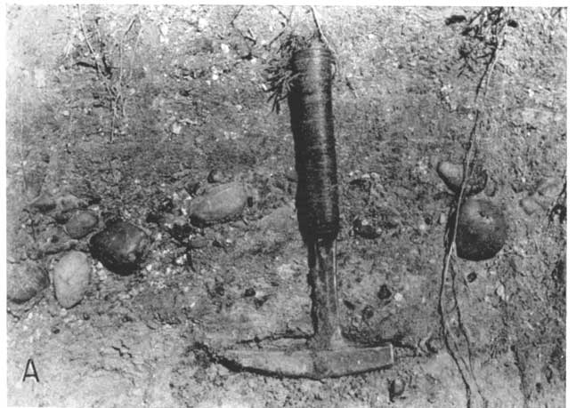
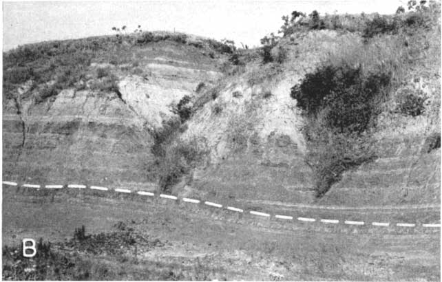
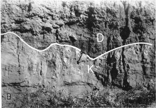
Plate 12B--Delmore formation, (D) unconformably overlying sandstone of the Kiowa shale (K) in the NE sec. 30, T. 18 S., R. 1 W. Photograph by S. W. Lohman.
Locally in McPherson County the sandstone in Twenhofel's Marquette member (1924, p. 31-32), bed 9 of his section given above, is tightly cemented by calcite or silica or both in beds and in large concretionary forms producing very resistant ledges. This rock generally is light to dark gray or pink on fresh fracture but it weathers brown. This "quartzite," as it is known locally, is quarried and crushed for road material at several of the quarries which are indicated on Plate 1 in Ts. 17 and 18 S., R. 1 W. and in T. 18 S., R. 1 E. Samples of the rock were collected and submitted to C. S. Ross of the U.S. Geological Survey for analysis. Specimen 1 was collected in the NW SW sec. 15, T. 18 S., R. 1 W. and specimen 2 was collected along the road in the NE sec. 24, T. 17 S., R. 2 W. The results of the analyses were reported as follows.
Specimen 1 is composed of angular to sub-angular quartz grains and minor amounts of plagioclase and microcline enclosed in a matrix of calcite. The quartz grains average about 0.3 mm in diameter. The calcite forms large areas up to 4 mm in diameter which extinguish as a unit. These calcite units contain as many as 100 or more quartz grains.
Specimen 2: Quartz grains show marked enlargement due to the deposition of secondary silica. In addition, calcedonic quartz fills or partly fills spaces between quartz grains.
It seems probable that the quartz and calcite indurating this otherwise poorly cemented sandstone were deposited by percolating ground water subsequent to the deposition of the sandstone. Although this zone of secondary cementation seems to be confined stratigraphically in this area, reports indicate that other Cretaceous sediments have been similarly affected elsewhere. Twenhofel (1924, p. 40) reports that the Windom member near the SW cor. sec. 16, T. 20 S., R. 6 W., in Rice County is a "quartzitic" coquina; Plummer and Romary (1942, p. 321 and 333) describe development of "quartzitic" facies of the lower member of the Dakota formation in Lincoln and Ellsworth counties; and McLaughlin (1943, p. 121) states that in Hamilton County, near Hartland, and in Morton County along the north fork of Cimarron River, the uppermost sandstone of the Dakota formation has been cemented by silica. Thus it seems that this zone has no regional stratigraphic significance.
The thickness of the Kiowa shale in this area ranges widely; the maximum thickness is about 120 feet. Test hole 59 penetrated 75 feet of Kiowa, and this and other logs given at the end of this report describe the character of the material composing the Kiowa in the subsurface.
Distribution and surface form.--The Kiowa shale crops out in the northwestern and northeastern parts of the area shown on Plate 1 and underlies the unconsolidated deposits in the area north of Galva and Canton and southeast of Canton toward Goessel.
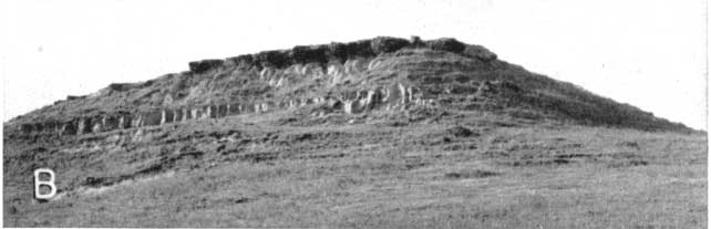
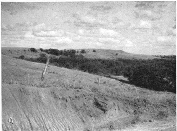
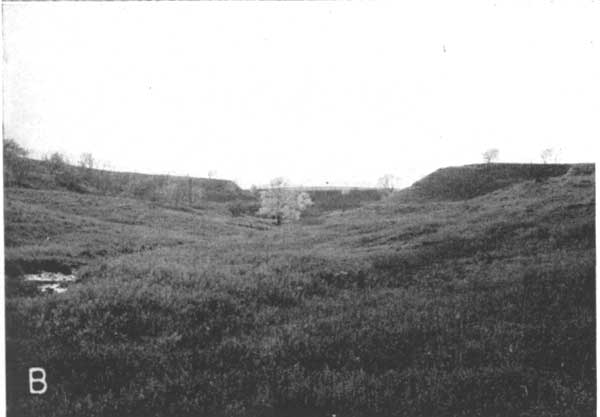
In general, the dark shale and sandy shale of the Kiowa weather rapidly and the resulting topography is flat or gently rounded; hence good exposures are limited to cut banks in small gullies. The beds of sandstone form prominent ledges and cap outlying hills in places where the sandstones have been tightly cemented with calcite, silica, or limonite (Pls. 9 and 13). Elsewhere the soft sandstones weather rapidly and gently rounded hills result.
Plate 13--Topographic expression of the Kiowa shale in northern McPherson County. A, View in northwestern part of T. 18 S., R. 2 W. B, View in the NE sec. 5, T. 18 S., R. 5 W. An intermittent spring occurs at the head of this ravine. Photograph A by S. W. Lohman; B by B. F. Latta.
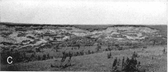
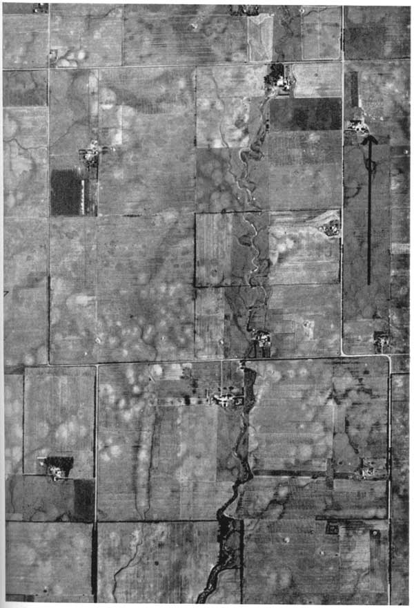
Subdued sand and silt hillocks or dune remnants sporadically occupy a long, narrow area which trends northeastward between Goessel and Canton (Pl. 14). This area has been mapped as being underlain by the McPherson formation (Pl. 1), but the deposits probably are derived from and underlain by the Kiowa.
Plate 14--Aerial photograph showing subdued une-like land forms in south-western Marion County. The square mile shown in upper center is sec. 32, T. 21 S., r. 1 E. The arrow points north and is about 0.5 mile long. U.S. Department of Agriculture photograph.
Age and correlation.--Authors cited above (especially Cragin, Prosser, Twenhofel, and Latta) have correlated the Kiowa in McPherson County with similar rocks in Kiowa County on the basis of similar fossils found in these deposits and, in part, on similarity of lithology. Plummer and Romary (1942, p. 322-325) correlated similar rocks in Ellsworth County with the Kiowa and recognized that the fossiliferous marine sandstones (Mentor beds) occurring in Rice and Saline counties and the unfossiliferous sands below them (Marquette sandstone) were part of the Kiowa shale. Frye and Brazil (1943, p. 21) agreed closely with Plummer and Romary but correlated the "Mentor beds" and "Marquette sandstone" with the Dakota formation.
The Kiowa shale is considered to be of Comanchean age by the State Geological Survey of Kansas, corresponding in age to some of the rocks in the Washita group of Texas.
Water supply.--The quantity and quality of the ground water available to wells from the Kiowa shale in this area are quite variable. Wells at Canton yield relatively hard water (analyses 65, B, and C) derived in part from sands in the Kiowa. No pumping-test data are available for this part of the area, but some of the sands in the Kiowa probably will yield water in sufficient quantity to supply small towns. Small-diameter drilled wells yield sufficient water for domestic and stock use throughout the areas underlain by sandstone, and small springs occur near the heads of many ravines which have cut into the sandstones. The black shale and sandy shale beds in the Kiowa yield meager supplies of very hard water to farm and stock wells. Test holes drilled east of Lindsborg (logs 1 to 13) revealed that the sandstone was not sufficiently permeable to supply the needs of that city, although the water was of comparatively good quality. Wells that penetrate the shale near Windom have been generally unsuccessful.
Tertiary System
Pliocene Series
Rocks containing fossils of middle Pliocene age crop out in the north-central part of the mapped area. Rocks deposited during other epochs of the Tertiary have not been identified in this area.
Lohman and Frye (1940; also, Frye and Hibbard, 1941) named that part of the McPherson formation they considered to be of Pliocene age the Emma Creek formation. During the summer of 1944, Williams, Hibbard, and Frye restudied the formations of the area, collecting many vertebrate fossils during the course of their investigation. This study has resulted in a number of changes in the age designation of certain beds that has affected the stratigraphic nomenclature of the area. The name Emma Creek is abandoned because the beds at the locality selected as the type of the formation are Pleistocene in age. Some of the beds which Lohman and Frye (1940) and Frye and Hibbard (1941) assigned to the Emma Creek have proved to be of Pliocene age and are a separate lithologic unit; these Pliocene beds are here designated the Delmore formation.
Delmore formation
The term Delmore formation is proposed for the Pliocene sediments underlying the area north and northwest of Canton and Galva (Pl. 1) in Delmore Township (T. 18 S., R. 2 W.) in McPherson County. These beds were originally assigned to the Emma Creek formation of Lohman and Frye (1940), the type beds of which were considered to be Pliocene in age. On the basis of the present study the beds at the type locality of the Emma Creek are now assigned to the Pleistocene and the name Emma Creek therefore is abandoned. The Delmore formation is lithologically distinct from the beds originally designated the Emma Creek and the Delmore does not extend into the type area selected for the Emma Creek. Good exposures of parts of the Delmore formation are found in secs. 24, 25, and 26, T. 18 S., R. 2 W. and there are many exposures along ravines in sec. 31, T. 18 S., R. 1 W. These localities lie within the area of outcrop and are considered to be the type area of the Delmore formation. This formation is believed to have been deposited during middle Pliocene time, a conclusion substantiated by the identification of vertebrate fossils collected from the outcrops and discussed by Hibbard (1948).
Character and thickness.--The Delmore formation is composed of calcareous, gray to buff silt and clay, fine- to coarse-grained sand, and some gravel. In places the calcium carbonate has been concentrated and forms irregularly shaped nodules and thin layers within the silt. About 20 feet of medium- to coarse-grained sand, overlain by 8 feet of tan silt, clay, and residual chert fragments, is well exposed at a sand pit on the J. M. Kinkerman farm in the SE sec. 30, T. 18 S., R. 1 W.
Coarse pebbles of quartz and ironstone derived from Cretaceous rocks are concentrated locally at the unconformable basal contact of the Delmore with older formations (Pl. 12B). The sand grains composing the sand beds and lenses in the Delmore formation range from fine to medium grade, and are composed dominantly of quartz but include also some feldspar, mica, or other minerals common to igneous rocks. The silt is buff and sandy where not calcareous; however, most exposures are characterized by the light-gray color of the silt derived from calcium carbonate grains.
The maximum thickness of the Delmore formation is about 75 feet as shown by test drilling. The character and thickness of this formation are described in logs 24, 25, 26, 27, and 66.
Origin.--The sediments comprising the Delmore formation seemingly were deposited by small tributaries that flowed southward and southwestward in McPherson County following the general depressional area, which is assumed then, as now, to have marked the outcrop of the shale of the Wellington formation. The sand in the Delmore obviously was derived from beds of sandstone in the Kiowa shale, which cropped out to the north and northeast; the silt and clay in the formation bear marked resemblance to material in the shales of the Kiowa and Wellington. The shale of the Wellington is calcareous, in part, gray to light gray in color, and is believed to have been the source of the gray color and calcium carbonate inclusions in the Delmore formation. Concretionary pink chert pebbles which characterize the Herington limestone at its outcrop and chert pebbles derived from other Permian limestone occur locally in silt in the upper part of the Delmore. These pebbles probably were brought into the area by streams and otherwise by movement downslope when tributary drainage was westward during an earlier cycle of erosion. The Flint Hills drainage divide formerly lay east of the outcrop of the Permian limestones that contributed the chert pebbles which now occur in the Delmore formation.
Distribution and surface form.--The Delmore formation crops out in northeastern McPherson County (Pl. 1) and occupies a relatively small part of the mapped area. The upper or southwestern boundary of the Delmore formation is indicated on Plate 1 by a dashed line; a more definite boundary cannot be drawn because of poor exposures. Southwestward from the heads of the ravines along which the Delmore is exposed, in the divide area between the Smoky Hill and Arkansas River drainage basins, an extremely flat topography remains undissected. The McPherson formation lies immediately south of the undissected area. Extending southwestward from the area of outcrop as far as McPherson, the Delmore formation underlies the Pleistocene McPherson formation. At McPherson a Tertiary fossil has been taken at depth from a gravel pit southeast of that city. The Delmore formation does not extend into the area designated by Lohman and Frye (1940) as the type locality for their Emma Creek formation (the beds now included in the McPherson formation). Local deposits of gray sandy silt occur along a ravine in the SW sec. 15, T. 17 S., R. 1 W. This gray silt probably is a part of the Delmore but the areal extent is very small and is not shown on Plate 1.
Age and correlation.--The presence of vertebrate fossils of middle Pliocene age in the sediments of the Delmore formation and the presence of Pleistocene deposits unconformably overlying the Delmore signify the middle Pliocene age of this formation. No fossils of late Pliocene age have been collected from the Delmore formation. The Delmore formation is equivalent in age to part of the Ogallala formation in western Kansas but was derived from different sources.
Water supply.The material comprising the Delmore formation is fine grained and poorly sorted compared with other unconsolidated deposits in this area, and comparatively small supplies of moderately hard water are available from the formation. Well 71, near Galva, yields about 30,000 gallons a day, and domestic and stock wells are adequately supplied from the Delmore. The City of Canton is supplied with water derived in part from this formation, and analyses 65, B, and C show the chemical character of the water at Canton.
Prev Page--Geologic Formations || Next Page--Geologic Formations--Quaternary
Kansas Geological Survey, South-central Kansas
Comments to webadmin@kgs.ku.edu
Web version April 2005. Original publication date July 1949.
URL=http://www.kgs.ku.edu/Publications/Bulletins/79/06_geocret.html