![]()
Prev Page--Contents || Next Page--Geology
Introduction
Included in the plans of the Missouri Basin Program for the development and utilization of all available water supply is the construction of the Cedar Bluff dam and the irrigation of about 13,000 acres of land lying on the north side of Smoky Hill River in southeastern Trego County and southwestern Ellis County in north-central Kansas. Figure 1 shows the location of the proposed dam and the locations of the cities and towns whose water supplies are described in the present report.
Figure 1--Index map of Trego, Ellis, and Russell counties, Kansas, showing the location of the proposed Cedar Bluff dam and near-by cities and towns.
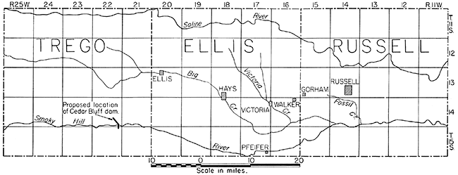
Plans for the Cedar Bluff irrigation project will take into consideration the question of whether provision must be made to supply water to the cities and towns of Hays, Victoria, Walker, Gorham, and Russell, Kansas, from the proposed reservoir; or whether adequate ground water is available to supply the present and future needs of those cities and towns.
For planning purposes it is assumed by the United States Bureau of Reclamation that the population of the several cities and towns will double within the next 40 to 50 years. In 1940, according to the Federal Census, the population of Hays was 6,385, that of Russell was 4,819, and that of Victoria was 844. Walker and Gorham are small unincorporated towns whose populations probably do not exceed 400.
In 1944 the State and Federal Geological Surveys, at the request of and in cooperation with the officials of Russell, made an investigation of the ground-water conditions in the Russell area to determine whether a supply of water of good quality adequate for the city's needs could be obtained from wells. The results of this investigation are given in an unpublished report by Thad G. McLaughlin (1944), who was in charge of the field investigation.
I spent 5 days in the Russell area during April 1946, conferred with city officials, mapped the geology in the vicinity of Hays, and selected sites for further test drilling in the vicinity.
In the Hays area 27 test holes were drilled by the United States Geological Survey in cooperation with the State Geological Survey of Kansas during April 1946, four of the holes being cased as observation wells. A portable hydraulic-rotary machine owned by the State Geological Survey was used to drill the test holes.
The following report is based upon the data thus collected, upon previously obtained data relating to the public water supply of Hays, upon data made available by the Kansas State Board of Health, and upon data from other sources. The section of the report dealing with the City of Russell is a summary of the report by McLaughlin.
Acknowledgments
The investigation made by the writer was under the supervision of V. C. Fishel, who is in charge of ground-water studies of the United States Geological Survey in Kansas. Acknowledgments are also made to V. A. Basgall, city manager of Hays, for furnishing data relating to the city wells and assisting me in other ways; to the Layne-Western Company, who furnished logs of wells and test holes drilled in the Hays area; to Lawrence Wellbrook, city manager of Victoria, who furnished data regarding the public water supply of that city; to Mr. Hamersmith, mayor of the town of Gorham, who furnished data regarding a proposed public water supply for that town; and to many other residents of the area who were most cooperative in supplying information and in giving permission to gather data on their properties.
Climate
The climate of the area considered is of subhumid to semiarid type, involving slight to moderate precipitation, moderately high average wind velocity, and rapid evaporation. The normal annual mean temperature at Hays is 54.1° F. In general the hottest month is July, with a normal mean temperature of 79.4° F., and the coldest month is January with a normal mean of 29.4° F.
The normal annual precipitation at Hays, determined by the U. S. Weather Bureau, is 23.05 inches, but the actual annual precipitation varies widely. The smallest precipitation of any year since the record was begun in 1868 was in 1894, when only 11.80 inches was recorded; and the greatest was in 1878, when 35.40 inches was recorded. Most of the precipitation occurs during the period April through September.
The annual precipitation for the period of record, and the cumulative departure from normal precipitation at Hays are shown in Figure 2. The curve of cumulative departure from normal has a roughly cyclic pattern of recurrent wet and dry periods. This area has experienced several prolonged dry periods in the past, the most recent being the drought of the 1930's, when the precipitation was below normal each year from 1933 through 1940. Other long periods of deficient rainfall were from 1892 through 1895, 1879 through 1884, and 1868 through 1873. In addition many shorter periods of deficient rainfall are recorded. Figure 2 shows the periods of drought and the alternating wet periods.Figure 2--Annual precipitation and cumulative departure from normal precipitation at Hays, Kansas. (From records of the United States Weather Bureau.)
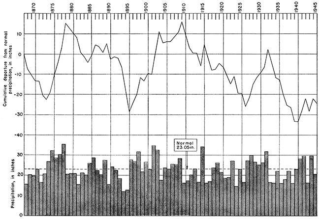
Although the cumulative rainfall for 1941-45 amounts to 8.72 inches above normal, the record indicates that prolonged dry periods are to be expected in the future. Rainfall studies are important in any ground-water investigation, for in general the amount of water demanded during any period varies inversely with the amount of precipitation and the amount of ground-water recharge in most areas varies with the precipitation received.
Topography
The cities and towns considered in this report lie about midway between Smoky Hill and Saline Rivers in Ellis and Russell Counties, Kansas. Saline River flows from west to east across northern Ellis County and a little north of the center of Russell County. Smoky Hill River crosses the southern parts of the same counties from west to east.
The largest tributary stream in this area is Big Creek, which flows in a southeasterly direction across central Ellis County and joins Smoky Hill River in southwestern Russell County. Victoria Creek, a tributary of Big Creek, drains a relatively small area in east-central Ellis County and joins Big Creek south of Walker.
The valleys of the larger streams are relatively flat and less than a mile to several miles in width. They are bordered in some places by terraces, the surfaces of which slope toward the valleys and are dissected by short tributary streams. Gentle to steep slopes separate the valleys and terraces from the upland surface.
The uplands over most of the area are formed by the Carlile shale, which has produced a relatively flat surface having an eastward slope. The gentle slope of the surface of the Carlile shale is broken north and west of Hays by a prominent escarpment produced by resistant chalk beds in the Niobrara formation.
The greater part of the City of Hays is located in the valley of Big Creek. The valley above Hays is about 1 to 1.5 miles wide, but a short distance below Hays it narrows abruptly to 0.5 to 0.8 mile in width. Big Creek is a meandering stream that occupies the northeast side of its valley above Hays, but in the narrow part of the valley southeast of Hays it is cutting against the southwest bluff, most of the valley plain in this area being northeast of the stream. The valley floor in the vicinity of Hays is in most places relatively smooth and has a gradual slope toward Big Creek. The valley floor has been dissected locally by small tributaries that drain into Big Creek.
Big Creek Valley in the Hays area is bordered on both sides by terraces which represent the floor of a large valley that was occupied by Big Creek when it was flowing at a higher level than it is today. The terrace along the north side of the valley ranges from less than 1 mile to about 2 miles in width and has a southward-sloping surface that has been dissected by many southward-flowing tributaries of Big Creek. The divide areas between the tributaries are at approximately the same height, and when viewed from a distance they appear to form a nearly level surface. The southeast edge of this terrace is only about 20 feet above the present floor of Big Creek Valley, whereas the north or outer edge is about 80 feet above the valley floor.
The terrace bordering the southwest side of the valley in the vicinity of Bays is similar to the north terrace except that the southern terrace slopes in a general easterly direction. No major topographic break occurs southwest of this terrace until an escarpment formed by chalk of the Niobrara formation is reached. This area may not be entirely underlain by terrace deposits, for the surface of the terrace deposits that are known to occur near the valley may be topographically continuous with the surface formed by the relatively soft Carlile shale southwest of the area. The escarpment formed by chalk of the Niobrara borders the terrace north and southwest of Hays and rises 80 to 120 feet or more above the terrace surfaces.
The City of Victoria is located on the northeast side of Victoria Creek, about 5 miles above its mouth. Victoria Creek in this area has a poorly defined valley. The land on each side of Victoria Creek slopes uniformly toward the stream and is crossed by many short tributary draws. Walker, Gorham, and Russell are located on relatively flat uplands.
Prev Page--Contents || Next Page--Geology
Kansas Geological Survey, Geohydrology
Placed on web Sept. 20, 2016; originally published Dec. 15, 1948.
Comments to webadmin@kgs.ku.edu
The URL for this page is http://www.kgs.ku.edu/Publications/Bulletins/76_6/02_intro.html