![]()
Prev Page--Geology || Next Page--Conclusions, References
Ground Water
Vicinity of Hays
Public Water Supply
The City of Hays has had a public water supply since 1903, when three dug wells of large diameter were constructed and curbed with brick. These early wells, two of which were not in use in 1946, range from 45 to 65 feet in depth and are supplied with water from the alluvium in Big Creek Valley.
Increasing demands for water caused by the growth of the city necessitated the construction of additional wells, and the city had 12 wells in operation during 1941. The city furnished water to the Walker Army Air Base, located about 11 miles east of Hays, during World War II. This requirement, plus an increased demand due to a wartime increase in population, overtaxed the existing wells. Therefore, two new wells were constructed during 1944 and one during 1945, which made a total of 15 wells in the city's public water system in 1946.
The locations of the city wells are shown on Figure 3, and information concerning them is given in Table 1. The well numbers given in the first column of this table are the numbers that have been assigned to the wells by the city. The water-level measurements were made by employees of the city.
Table 1--Records of city wells at Hays, Kansas
| Well no. on Fig. 3 |
Year drilled |
Type of Well |
Depth, feet |
Diameter, inches |
Type of casing |
Depth to water level below land surface, feet |
Date of measurement |
Altitude of land surface, feet |
Reported yield, Dec. 1945, gallons a minute (a) |
Remarks (Reported yield given in gallons a minute; draw down in feet) |
|---|---|---|---|---|---|---|---|---|---|---|
| 1 | Drilled | 49 | 24 | Steel | 39.80 | Jan. 19, 1946 | 1991.1 | 75 (24) 100 (8) |
Yield when new 160, drawdown 4. | |
| 3 | 1903 | Drilled | 49 | 6 | Steel | 40.50 | Jan. 19, 1946 | 1992.7 | 90 (12) | Battery of two wells, one horizontal centrifugal pump. Measured east well. Yield when new 125, drawdown 7. |
| 6 | 1926 | Drilled | 48 | 24 | Concrete | 38.90 | Jan. 19, 1946 | 1991.1 | 80 (24) | Yield when new 100, drawdown 8. |
| 7 | 1927 | Drilled | 48 | 14 | Steel | 36.21 | Jan. 19, 1946 | 1996.3 | 75 (24) | Yield when new 80, drawdown 14. |
| 8 | 1927 | Drilled | 64 | 14 | Steel | 48.00 | Jan. 19, 1946 | 2014.0 | 90 (10) | Yield when new 80, drawdown 14. |
| 10 | 1935 | Dug | 35 | 120 | Brick | 28.00 | Jan. 18, 1946 | 1988.7 | 75 (24) | Yield when new 110, drawdown 4. |
| 12 | 1937 | Drilled | 34 | 10 | Steel | 26.40 | Jan. 18, 1946 | 1986.5 | 65 (24) | Battery of two wells and one pump. Yield when new 75, drawdown 10. |
| 13 | 1937 | Dug | 38 | 240 | Brick | 29.10 | Jan. 19, 1946 | 1978.8 | 30 (8) | Yield when new 180, drawdown 7. |
| 14 | 1938 | Drilled | 51.5 | 19 | Concrete | 26.85 | Jan. 19, 1946 | 1976.9 | 100 (24) 140 (10) |
|
| 15 | 1938 | Drilled | 51 | 19 | Concrete | 26.61 | May 22, 1943 | 1979.6 | 180 (24) 225 (10) |
Yield when new 300, drawdown 14. |
| 16 | 1941 | Drilled | 54 | 12 | Steel | 24.84 | Oct. 22, 1942 | 1980.9 | 90 (24) | Yield when new 100, drawdown 10. |
| 17 | 1941 | Drilled | 68 | 12 | Steel | 48.95 | May 22, 1943 | 2012.1 | 180 (24) | Yield 260 when new. |
| 18 | 1944 | Drilled | 52.7 | 12 | Steel | (b) 40 | June | 1991.4 | 80 (24) 100 (10) |
Yield 125 when new. |
| 19 | 1944 | Drilled | 44.5 | 12 | Steel | (b) 24.8 | June 1944 | 1979.1 | 180 (24) 200 (8) |
Yield 295, drawdown 14 when new. |
| 20 | 1945 | Drilled | 53.7 | 12 | Steel | (b) 34 | August 1945 | 200.5 | 200 (24) | Yield 250 when new. |
| (a) Number in parentheses indicates number of hours a day that well can be pumped at the rate shown. (b) Reported by driller. |
||||||||||
Of the 15 city wells, 14 tap the alluvium in Big Creek Valley and one (well 17) taps the terrace deposits north of the valley. All but two (wells 10 and 13) are drilled wells ranging from 34 to 68 feet in depth cased with steel or concrete. Wells 10 and 13 are dug wells of large diameter that are 35 and 38 feet deep, respectively, and are curbed with brick. The depth to water level in the wells ranges from about 24 feet to nearly 50 feet below the surface. The drilled wells, with the exception of wells 3 and 12, are gravel packed.
The yield of each city well as reported for December 1945 is given in Table 1. Some of the. wells are not capable of being pumped continuously, but can be pumped only a few hours each day, then must be shut off to allow the well to recover. Well 13, for example, is capable of supplying only 30 gallons a minute for 8 hours a day. Wells 3 and 8 yield 90 gallons a minute for 12 and 10 hours a day, respectively. The other wells are reported to yield 65 to 200 gallons a minute continuously, and average about 115 gallons a minute.
It is important to note from Table 1 that the yields of all the wells have declined since they were drilled. The amount of decline in yield has been relatively small for some wells, but for others it has been more than 100 gallons a minute. Wells 18 and 19, drilled in June 1944, and well 20, drilled in August 1945, already show declines in yield of about 35, 40, and 20 percent, respectively. In an area such as this, where the water-bearing material is relatively thin and the amount of possible drawdown is limited, decrease in yield is a necessary result of the development of a cone of depression to intercept recharge or reduce natural discharge.
Records of the amount of water used by the city and by the Walker Army Air Base during each month from July 1942 to March 1946 were obtained. These data are shown graphically in Figure 5. The consumption of water at Hays has steadily increased in the past and will continue to increase as the population grows. The consumption of water is least during the winter months December through March, and is greatest during the summer months of June through September.
Figure 5--Hydrographs of five city wells, cumulative departure from normal monthly precipitation, and monthly pumpage from city wells at Hays from 1942 to 1946.
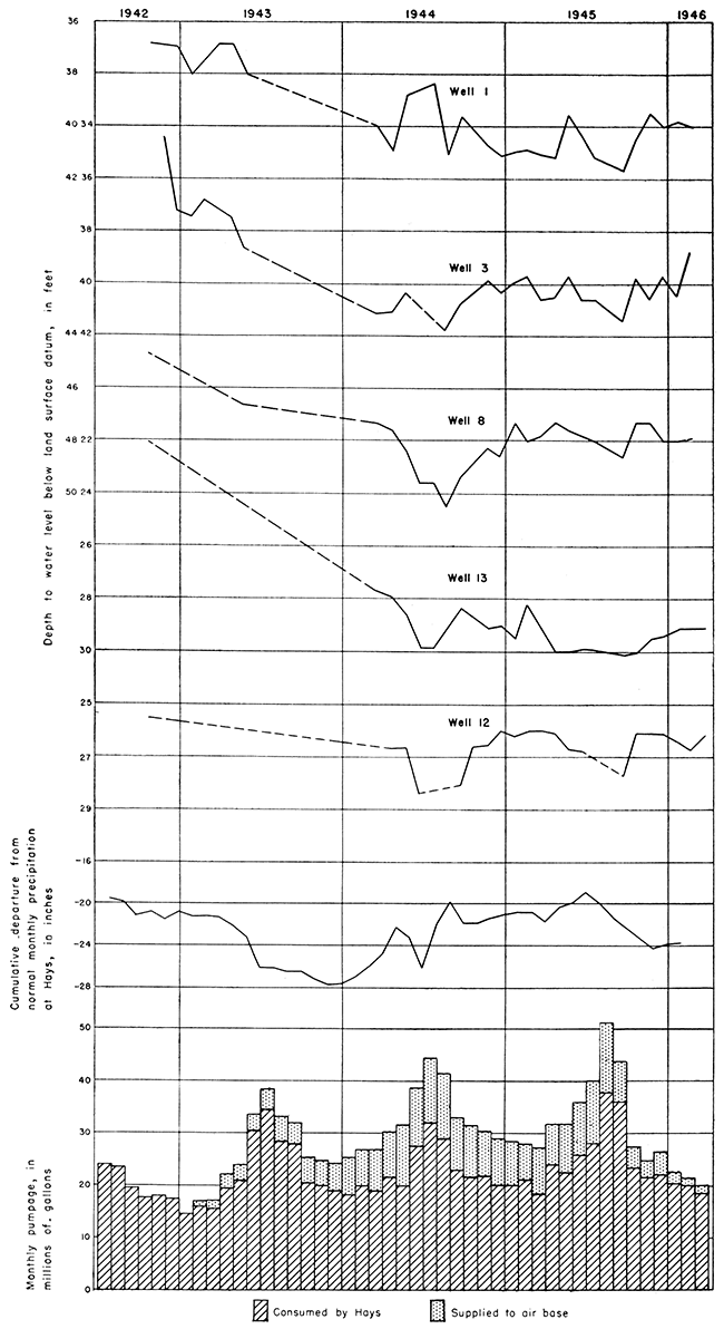
Table 2 shows the amount of water used by the city and by the air base for January, when the demand for water is generally the least; and for August, when the demand is generally the greatest, during the period 1942-1946.
Table 2--Monthly consumption of water by the City of Hays and the Walker Army Air Base for January and August during the period 1942-1946 (in millions of gallons).
| Year | January | August | ||||
|---|---|---|---|---|---|---|
| Hays | Air base | Total | Hays | Air base | Total | |
| 1942 | 23.5 | 0 | 23.5 | |||
| 1943 | 14.5 | 0 | 14.5 | 28.5 | 4.6 | 33.1 |
| 1944 | 18.3 | 7.1 | 25.4 | 29 | 12.3 | 41.3 |
| 1945 | 20 | 8.5 | 28.5 | 37.7 | 13.8 | 51.5 |
| 1946 | 20.2 | 2.3 | 22.5 | |||
The minimum monthly consumption of water at Hays proper during this period was 14,500,000 gallons in January 1943; and the maximum monthly consumption was 37,700,000 gallons in August 1945. The total consumption of water at Hays and the air base for August 1945 was 51,500,000 gallons, which was the maximum amount of water that could be supplied from the wells. Warnings were issued in the local paper during this month informing the townspeople of a shortage of water and asking them to economize as much as possible in its use. It is believed that had there been an adequate supply of water the total consumption would have reached 60,000,000 gallons, and of this amount the city would have used about 46,000,000 gallons.
The trend of population at Hays indicates that within the next 40 or 50 years it may become twice as large as it was in 1946. This will at least double the demand for water, and an increased number of industries and the increased use of water for air conditioning during the summer months may more than double the water consumption.
Shape of the Water Table and Movement of Ground Water
The approximate shape of the water table in part of the Hays area is shown by the contours in Figure 6. As a basis for constructing this map the altitude of the land surface at most of the test holes, observation wells, and city wells was determined by instruments. Data for the four observation wells drilled by the State and Federal Geological Surveys and for all the test holes are given in Table 3 and the data for the city-supply wells are given in Table 1. The altitude of the water surface in Big Creek at nine points in the Hays area was determined instrumentally.
Figure 6--Map of the Hays, Kansas, area showing water-table contours, 1946.
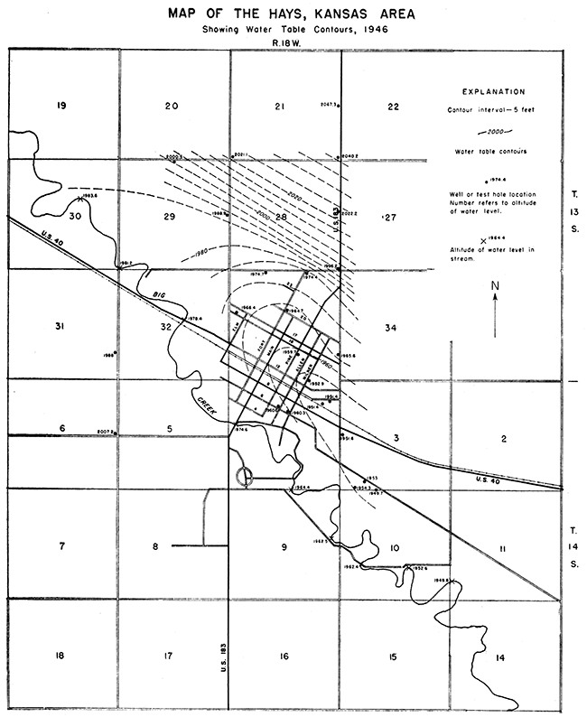
Table 3--Records of observation wells and test holes in the vicinity of Hays, Kansas
| No. on Fig. 3 |
Location | Driller (a) |
Depth of test hole or well, feet |
Depth to water level below land surface, feet (b) |
Date of measurement |
Altitude of land surface, feet (c) |
|---|---|---|---|---|---|---|
| T. 13 S., R. 18 W. | ||||||
| 1 | NE cor. SE sec. 20 | S | 60 | 2,065.8 | ||
| 2 | NE cor. SE sec. 21 | S | 30 | 9.1 | 4/19/46 | 2,076.4 |
| 3 | SW cor. sec. 21 | S | 35 | 23.9 | 4/17/46 | 2,045.0 |
| 4 | SW cor. SE sec. 21 | S | 40 | 2,0489. | ||
| 5 | SE cor. sec. 21 | S | 50 | 13.5 | 4/13/46 | 2,053.7 |
| 6 | SE cor. NE sec. 28 | S | 40 | 23.4 | 4/19/46 | 2,045.6 |
| 7 | SE cor. sec. 28 | S | 80 | 41.6 | 4/13/46 | 2,037.8 |
| 8 | NE cor. NW sec. 29 | S | 76 | 49.9 | 4/19/46 | 2,050.4 |
| 9 | SE cor. NE sec. 29 | S | 85 | 54.3 | 4/17/46 | 2,043.2 |
| 10 | SE cor. sec. 29 | S | 80 | 2,027.8 | ||
| 11 | NW NW NE sec. 30 | L | 48 | 22.2 | 11/44 | 2,011 |
| 12 | SW NW NE sec. 30 | L | 48 | 23.5 | 11/44 | 2,012 |
| 13 | NW SW NE sec. 30 | L | 48 | 23.4 | 11/44 | 2,011 |
| 14 | NW SW NE sec. 30 | L | 43 | 24.0 | 11/44 | 2,010 |
| 15 | NE SW NE sec. 30 | L | 49 | 22.0 | 11/44 | 2,009 |
| 16 | NE SW NE sec. 30 | L | 40 | 22.0 | 11/44 | 2,008 |
| 17 | NW SE NE sec. 30 | L | 35 | 22.5 | 11/44 | 2,007 |
| 18 | NE SE NE sec. 30 | L | 49 | 21.8 | 11/44 | 2,007 |
| 19 | SE SE NE sec. 30 | L | 40 | 26.1 | 11/44 | 2,009 |
| 20 | SE SE NE sec. 30 | L | 40 | 22.8 | 11/44 | 2,007 |
| 21 | NE NE SE sec. 30 | L | 48 | 21.2 | 11/44 | 2,005 |
| 22 | SE NE SE sec. 30 | L | 44 | 21.3 | 11/44 | 2,005 |
| 23 | NE SE SE sec. 30 | L | 47 | 22.6 | 11/44 | 2,006 |
| 24 | NE NE NE sec. 31 | L | 40 | 18.1 | 11/44 | 2,000 |
| 25 | SE NE NE sec. 31 | L | 45 | 19.0 | 11/44 | 2,001 |
| 26 | NE SE NE sec. 31 | L | 28 | 17.0 | 11/44 | 2,000 |
| 27 | SE SE NE sec. 31 | L | 28 | 15.0 | 11/44 | 1,999 |
| 28 | SE SE NE sec. 31 | L | 25 | 15.0 | 11/44 | 2,000 |
| 29 | NE NE SE sec. 31 | L | 28 | 2,001 | ||
| 30 | NE NE SE sec. 31 | L | 50 | 21.0 | 11/44 | 2,003 |
| 31 | SE NE SE sec. 31 | L | 53 | 2,005 | ||
| 32 | NE cor. SE SE sec. 31 | S | 60 | 21.0 | 4/20/46 | 2,009.0 |
| 33 | NE SE SE sec. 31 | S | 60 | 31.8 | 4/20/46 | 2,011.1 |
| 34 | SE SE SE sec. 31 | S | 45 | 33.5 | 4/22/46 | 2,014.5 |
| 35 | SW cor. sec. 32 | S | 50 | 40.5 | 4/22/46 | 2,020.4 |
| 36 | NW NE NW sec. 33 | S | 70 | 49.5 | 4/16/46 | 2,024.2 |
| 37 | NE NW NE sec. 33 | S | 80 | 53.4 | 4/15/46 | 2,027.8 |
| 38 | SE NW sec. 33 | S | 70 | 55.4 | 4/27/46 | 2,020 |
| 39 | SE SE NE sec. 33 | S | 75 | 2,025.1 | ||
| 40 | NE NE SE sec. 33 | S | 70 | 2,020.1 | ||
| 41 | NE cor. SE SE sec. 33 | S | 60 | 35.8 | 4/12/46 | 2,001.4 |
| 42 | SE SE SE sec. 33 | L | 50 | |||
| 43 | SW SW sec. 34 | L | 55 | |||
| T. 14 S., R. 18 W. | ||||||
| 44 | (d) SW SW NW sec. 3 | S | 43 | 34.1 | 4/27/46 | 1,985.7 |
| 45 | (d) SW SW sec. 3 | S | 39 | 27.1 | 4/25/46 | 1,980.1 |
| 46 | SE NE NE sec. 4 | L | 50 | 1,994 | ||
| 47 | SE NE NE sec. 4 | L | 47 | 40.0 | 11/43 | 1,993 |
| 48 | NE SW NW sec. 4 | L | 31 | 1,989 | ||
| 49 | NW SE NW sec. 4 | L | 33 | 1,988 | ||
| 50 | (d) SE SE NW sec. 4 | S | 36 | 26.1 | 4/27/46 | 1,986.0 |
| 51 | NE NE NE sec. 6 | S | 60 | 2,030.3 | ||
| 52 | NE cor. SE NE sec. 6 | S | 66 | 2,037.9 | ||
| 53 | SE cor. NE sec. 6 | S | 40 | 24.0 | 4/23/46 | 2,031.2 |
| 54 | NE cor. sec. 7 | S | 25 | 2,031.7 | ||
| 55 | SE SW sec. 3 | L | 45 | 24.5 | 11/43 | 1,977 |
| 56 | NE NW NW sec. 10 | L | 40 | 23.1 | 11/43 | 1,979 |
| 57 | NE NW NW sec. 10 | L | 40 | 22.1 | 11/43 | 1,977 |
| 58 | NE NE NW sec. 10 | L | 33 | 16.8 | 11/43 | 1,976 |
| 59 | NE NE NW sec. 10 | L | 33 | 23.3 | 11/43 | 1,976 |
| 60 | NE NE NW sec. 10 | L | 33 | 18.4 | 11/43 | 1,975 |
| 61 | SW NE NW sec. 10 | L | 38 | 18.3 | 11/43 | 1,976 |
| 62 | SW NE NW sec. 10 | L | 42 | 19.0 | 11/43 | 1,975 |
| 63 | SW NE NW sec. 10 | L | 38 | 19.0 | 11/43 | 1,975 |
| 64 | SW NW NE sec. 10 | L | 40 | 18.0 | 11/43 | 1,975 |
| 65 | NE SE NW sec. 10 | L | 36 | 18.0 | 11/43 | 1,975 |
| 66 | NE SE NW sec. 10 | L | 36 | 18.1 | 11/43 | 1,975 |
| 67 | SE SE NE sec. 10 | L | 50 | 20.0 | 11/44 | 1,974 |
| 68 | NE NE SE sec. 10 | L | 35 | 18.4 | 11/44 | |
| 69 | NE NE SE sec. 10 | L | 50 | 19.0 | 11/44 | 1,973 |
| 70 | Center NE SE sec. 10 | L | 29 | 18.0 | 11/44 | |
| 71 | NE NE SE sec. 10 | L | 51 | 18.0 | 11/44 | 1,972 |
| 72 | SE NE SE sec. 10 | L | 48 | 17.7 | 11/44 | 1,972 |
| 73 | SE NE SE sec. 10 | L | 48 | 19.7 | 11/44 | 1,971 |
| 74 | SE SE SW sec. 11 | L | 33 | 14.8 | 11/44 | |
| 75 | NE NE NW sec. 14 | L | 38 | 14.0 | 11/44 | |
| 76 | NE NE NW sec. 14 | L | 36 | 14.8 | 11/44 | |
| 77 | NE NW NW sec. 14 | L | 40 | |||
| (a) S. State and Federal Geological Surveys: L. Layne-Western Company. (b) Water levels in the wells and test holes drilled by the State and Federal Geological Surveys were measured by James B. Cooper; all other measurements were furnished by the Layne-Western Company. (c) The altitudes for the test holes drilled by the Layne-Western Company are approximate only. (d) Observation well. |
||||||
The water-table contours in the terrace area north of Hays are nearly parallel to the valley, indicating that the movement of the ground water in the terrace deposits is toward the valley. The gradient of the water table in this area is very steep, being about 60 feet to the mile. The slope of the water table in the valley is in general downstream, indicating that the ground water after entering the alluvium moves down the valley. The upstream flexure of the 1,985-foot contour above Hays shows that the ground water in this area is moving toward Big Creek (see also section A-A' in Fig. 3); thus Big Creek upstream from Hays may receive some water from the zone of saturation.
Before there were any heavy withdrawals of ground water in the vicinity of Hays, seepage to Big Creek probably took place throughout the valley in the Hays area. Heavy pumping of the city wells in and southeast of Hays, however, has caused a local trough in the water table to be formed northeast of the creek. The form of this trough is shown in profile by section B-B' in Figure 4. At Hays and for a short distance downstream, the water table on the northeast side of Big Creek is below its channel. Big Creek in this part of the area may contribute some water to the underground reservoir, but because of the low stream flow during most of the year the amount of water contributed in this way probably is small. Furthermore, the test-hole data indicate that the channel of Big Creek is underlain by several feet of silt and clay (Fig. 4). This material is relatively impermeable and would retard or prevent the movement of water from the stream to the water table.
The depth of water beneath the terrace north of Hays differs roughly according to the topography of the land surface. In general it ranges from less than 10 feet near the bluffs of Cretaceous rocks to about 55 feet along the edge of the terrace. In 1945-46 the measured depths to water in the valley ranged from 15 to 47 feet. The greatest depths to water in the valley are at Hays, where the water table has been lowered by the heavy withdrawals from the city wells.
Fluctuations of the Water Table
The City of Hays began keeping records of the water levels in the city wells in October 1942. These records are complete for most wells except for the period from June 1943 to March 1944, when no records were kept. Periodic measurements have been made in wells 1, 3, 6, 7, 8, 10, 12, and 13; and monthly gage readings have been taken at the other wells. The measurement or gage reading has been made at each well after it has been idle for several hours to several days.
Figure 5 shows hydrographs of wells 1, 3, 8, 12, and 13, the cumulative departure from normal monthly precipitation at Hays from July 1942 to January 1946, and the total monthly pumpage from the Hays wells from July 1942 to March 1946. The wells for which hydrographs are given were selected as representative of the city wells and are believed to show the general trend of water-level fluctuations in all the wells.
Of the eight wells in which tape measurements were made, all but well 10 showed net declines in water level from the beginning of record, in October 1942, to October 1945. The declines in water level in these wells ranged from 0.53 to 7.97 feet and averaged 3.21 feet. As shown by the hydrographs the greatest decline in water levels for this period occurred during 1943, partly as the result of the relatively heavy pumping and partly as the result of a deficiency in normal precipitation, which amounted to 6.86 inches.
Both the precipitation and the pumpage were greater in 1944 and 1945 than they were in 1943. The precipitation in 1944 was 6.65 inches above normal and in 1945 it was 2.71 inches below normal. During this 2-year period part of the wells showed net rises in water levels and part showed net declines. Of the eight wells for which tape measurements of the water levels are available, five wells (nos. 1, 3, 7, 10, and 12) showed net rises in water level of .09 to 1.95 feet for the period from March 1944 to March 1946, and three wells (nos. 6, 8, and 13) showed net declines of 0.90 foot, 0.29 foot, and 1.4 feet, respectively.
The fluctuations of the water levels in the Hays wells depend in part on the amount of water pumped and in part upon the amount of precipitation received. Although the pumpage during 1944 and 1945 was greater than it had been in previous years, the amount of recharge to the ground-water reservoir from precipitation was sufficient to prevent any great lowering of the water table. Pumpage from the city wells plus a deficiency in precipitation in 1943 caused the water levels to decline several feet in most of the wells, even though the amount of water withdrawn from the ground-water reservoir was less than in 1944 and 1945. Although the precipitation in 1944 and 1945 was greater than in 1943, the greater amount of withdrawal prevented the water levels from returning to the position they had at the beginning of 1943.
From the standpoint of precipitation the period for which water-level measurements are available, from 1942 to 1946, was in general a favorable period for ground-water recharge. Although earlier water-level measurements are not available for comparison, the shape of the water table in April 1946 (Fig. 6) indicates that since pumping began there has been a general lowering of the water levels in the vicinity of Hays as the result of heavy withdrawals of water from the city wells. During future periods when the precipitation is below normal for several consecutive years, and withdrawals continue heavy, the water levels in this area may decline even more.
Prospect for Additional Supplies
Big Creek Valley--The amount of water that can be pumped from an underground reservoir without causing excessive permanent lowering of the water table depends on the capacity of the reservoir and on the amount of annual recharge to the reservoir. If water is withdrawn from an underground reservoir by pumping faster than water enters it, the water levels in wells will decline and if this condition persists the supply eventually will be depleted. The hydrographs in Figure 5 indicate that the total amount of water withdrawn by wells in Big Creek Valley in the immediate vicinity of Hays from 1942 to 1945 exceeded the amount of water added by recharge.
During 1944 and 1945, when the precipitation was high, the amount of water withdrawn by wells was nearly equal to the amount added by recharge; but during 1943, when the precipitation was below normal, the amount of water withdrawn by wells exceeded the amount added by recharge. It should be noted that the amount of pumpage in 1943 was less than in 1944 and in 1945.
Additional wells could be constructed in certain areas in the valley northwest and southeast of Hays. Each well, if properly constructed, probably would yield 75 to 150 gallons a minute; but nowhere in the valley in the Hays area are the conditions favorable for developing very large supplies of water from wells. The character and thickness of the alluvium northwest of Hays is indicated by the logs of test holes 11 to 35, and by profile A-A' on Figure 4.
The valley in this area is about 1.2 miles wide and the total thickness of the alluvium ranges from about 20 to 55 feet. The thickness of the saturated part of the alluvium ranges from about 6 feet over a bedrock ridge south of Big Creek to 34 feet in the deepest part of the old bedrock channel. The thickest and coarsest water-bearing materials in this area were encountered in test holes 11, 12, and 13 north of Big Creek, and in test holes 34 and 35 near the southwest bluff of the valley.
Southeast of Hays the valley is less than three-quarters of a mile wide in most places. The alluvium in this part of the valley ranges from about 25 to 50 feet in thickness and generally contains less productive water-bearing materials than it does at Hays. The thickest and coarsest water-bearing materials in this area were encountered by test holes 72 and 73.
Terrace areas--City well 17 is located on the terrace that borders the northeast side of Big Creek Valley. This well has a reported yield of 180 gallons a minute. Available data indicate that additional wells having comparable yields can be developed in this area in a narrow belt about three-quarters of a mile wide along the edge of the terrace. The terrace deposits in this narrow belt have a total thickness ranging from about 60 to 81 feet (test holes 7 to 10 and 36 to 40). The depth to water in this part of the terrace ranges from about 40 to 55 feet below the surface. The amount of water-bearing sand and gravel, however, varies widely. Test holes 7 and 9, for example, encountered less than 5 feet of water-bearing sand and gravel, whereas test holes 8 and 37 encountered -21 feet and 25 feet of water-bearing sand and gravel, respectively.
The materials making up the terrace deposits in the area northeast of this narrow belt are relatively thin and consist predominantly of fine sediments, as indicated by the logs of test holes 1 to 6. For this reason, successful public-supply wells could not be developed in the northern part of the terrace area.
Test holes 53 and 54, drilled on the terrace southwest of Hays, failed to encounter sand and gravel. Test holes 51 and 52, near the edge of the terrace, encountered 15 feet and 9 feet of water-bearing sand and gravel, respectively. Although sufficient data for this area are lacking, it seems that wells having small yields probably could be developed along the edge of the terrace.
Certain procedures should be followed in locating and constructing future wells, whether in the valley or on the terraces, to take the fullest advantage of the local conditions. The wells should be spaced as far apart as practicable, preferably a quarter of a mile or more, to prevent local overdevelopment; and the rate of pumping from individual wells should be less than the potential yields indicated by pumping tests. The drilling of each well should be preceded by the drilling of a test hole, to determine the thickness and character of the water-bearing material, the proper length and slot size of the screen to employ, and the proper type of wen construction for the final well.
Summary--The test drilling did not indicate any place in the Hays area where large supplies of water could be obtained from wells. Additional wells having yields comparable to the existing city wells could be developed in parts of the valley northwest and southeast of Hays and in parts of the terrace areas. The test drilling indicated that the number of localities in the valley and in the terrace areas having a sufficient thickness of coarse water-bearing material to supply a city well are limited. Because of the narrowness of the valley and small amount of coarse water-bearing material in the alluvium southeast of Hays, only a relatively small supply of water could be developed in the valley in this part of the area:
By locating wells over a wide area an additional amount of water could be obtained, probably equal to the present public supply. If the ground water in the outlying localities is not developed for public supply, it will be available in moderate amounts for industries or other establishments in these localities.
Vicinity of Victoria
Public Water Supply
The public water-supply system at Victoria was constructed in 1921 and consists of five wells situated south, west, and northwest of the town as shown in Figure 7. Records of the five wells are given in Table 4. Some of the data given in this table were obtained from Mr. Lawrence Wellbrock, city water superintendent, and some were obtained from annual engineering reports on file in the office of the Division of Sanitation, Kansas State Board of Health, at Lawrence, Kansas.
Figure 7--Map showing the locations of the city wells at Victoria, Kansas.
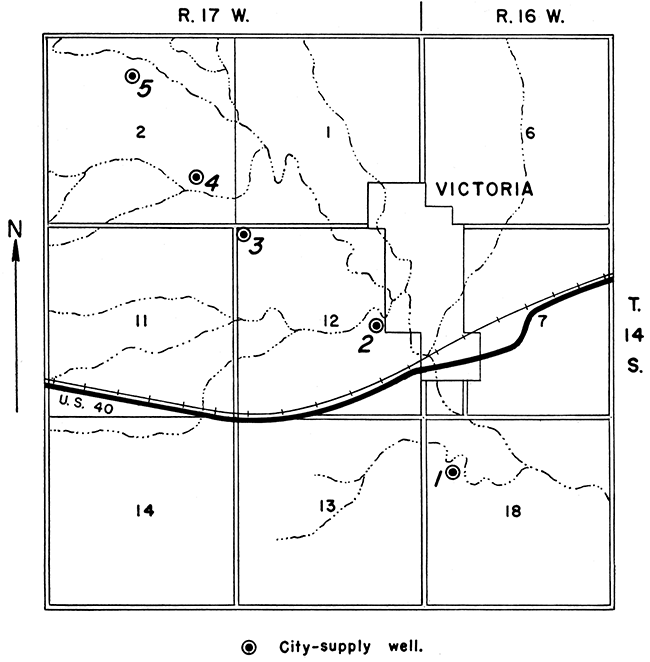
Table 4--Records of city wells at Victoria, Kansas
| Well no. on Fig. 7 |
Location | Type of well |
Depth, feet |
Diameter, inches |
Type of casing |
Reported depth to water level below land surface, feet |
Reported yield, gallons a minute |
Remarks |
|---|---|---|---|---|---|---|---|---|
| T. 14 S., R. 16 W. | ||||||||
| 1 | NE SW NW sec. 18 | Dug | 34 | 180 | Brick | 25 | 70 | Reported to pump dry in 3 hours. |
| T. 14 S., R. 17 W. | ||||||||
| 2 | NE SE sec. 12 | Dug | 34 | 360 | Tile | 28 | Small | Reported to pump dry in a very short time. |
| 3 | NW cor. sec. 12 | Dug | 50 | 144 | Stone | 26 | 25 | Reported to pump dry in 3 hours. |
| 4 | NW SE SE sec. 2 | Dug | 40 | 180 | Stone | |||
| 5 | SE NE NW sec. 2 | Drilled | 34 | 12 | Steel | 28 | Gravel packed. | |
According to the engineering reports of the Kansas State Board of Health, Victoria has experienced difficulties in the past. in obtaining adequate water, especially during summers when the rainfall is least and the consumption is the greatest. During the summer of 1930 the supply, which was obtained from wells 1 and 2, was insufficient to meet the demand, and it was necessary to place restrictions on the use of water. It is reported that had the summer rate of consumption continued very much longer in 1934 the supply from wells 1, 2, and 3 would have failed. Well 2 failed entirely during the summer of 1934. In August 1937 well 2 could be pumped only 35 minutes a day.
In 1944 the supply from five wells was inadequate to meet the summer demand. In 1946 wells 1, 2, and 3 could be pumped dry in a few hours.
Because of the thinness and low permeability' of the water-bearing materials in the terrace deposits and alluvium in Victoria Creek Valley, wells that tap these deposits are limited to relatively small yields; and, as the source of recharge is the small amount of precipitation that falls on this area, the wells are subject to marked declines in yield or to complete failure during prolonged dry periods.
The city does not have a public sewerage system, but one may be installed in the future. Records of the consumption of water at Victoria are not available. According to records of the Kansas State Board of Health (1945), cities in Kansas of the size of Victoria which have sewerage systems generally require 50,000 to 150,000 gallons of water a day.
Prospect for Additional Supplies
Although additional wells having small yields can be developed in some places in the terrace and alluvial deposits along Victoria Creek, the data indicate that the amount of water available from these deposits near Victoria would be insufficient during prolonged dry periods to supply the anticipated future demand of the city. Adequate water probably could be obtained by supplementing this supply with water pumped from wells tapping the alluvium in Victoria Creek Valley several miles below Victoria or from wells tapping the alluvium in Big Creek Valley southeast of Victoria.
Vicinity of Walker
Walker does not have a public water-supply system, as an adequate supply of ground water of satisfactory quality for public use is not available in the vicinity of the town. Probably the nearest source of a ground-water supply is in the alluvial deposits in Victoria Creek Valley about 3 1/2 miles southwest of the town. Test holes drilled in that area, in the S2 NE sec. 21, T. 14 S., R. 16 W., encountered 10 to 20 feet of water-bearing sand and gravel at the base of the alluvium.
A test well was constructed near Walker in September 1942, by the Layne-Western Company for the United States Army Air Base. It was a gravel-packed well, 36 feet deep and 8 inches in diameter. The depth to water level in the well was 17.26 feet below the land surface on September 24, 1942. During a 7-hour pumping test the well discharged an average of 35 gallons a minute, with a maximum drawdown of 5.6 feet.
Vicinity of Gorham
Gorham does not have a public water supply. In 1941 the town, with the aid of the Works Progress Administration, started construction of a public water-supply system; but this project was stopped because of the war.
Neither the Cretaceous nor the Tertiary rocks in the vicinity of Gorham would be capable of furnishing adequate water of good quality for a public supply.
Records of two dug wells near Gorham that tap Tertiary deposits are available. One of these is at the SE cor. sec. 29, T. 13 S., R. 15 W., about 1 mile east of Gorham, and is 23.7 feet deep and 36 inches in diameter. On August 29,1941, this well contained only 1.7 feet of water. The other well is in the SE NW sec. 30, T. 13 S., R. 15 W., about three-quarters of a mile northwest of Gorham. This well is 25.6 feet deep,,48 inches in diameter, and on August 29, 1941, contained only 2 feet of water.
In 1941 the city drilled two test wells in Tertiary deposits north of town in the search for a public water supply. Specific information on these test wells is not available; but, according to Mr. Hamersmith, the first well, in the SW sec. 29, T. 13 S., R. 15 W., was a complete failure; and the second well, in the SE sec. 30, T. 13 S., R. 15 W., encountered a little water-bearing sand and gravel, but the amount of water available was inadequate for a public-supply well.
The Gorham school well is supplied with water from thin alluvial deposits in a small valley at the west edge of town. It is a dug well of large diameter about 15 feet deep, in the SW NE sec. 31, T. 13 S., R. 15 W. The supply available from this well is reported to be adequate to meet the needs of the school, but this fact does not indicate that the alluvium at the locality would be a reliable source for a public supply. The amount of water pumped from the school well is relatively small compared to the amount that would be pumped from public-supply wells. Furthermore, the school well is not pumped during the summer months, when the demands of the town are the greatest and recharge to the underground reservoir is the least. A number of small wells tapping the alluvium probably would furnish adequate water for future needs during periods of normal rainfall, but because of the thinness of the saturated material such wells would be subject to failure during periods of drought.
Vicinity of Russell
Public Water Supply
The municipal water supply for Russell is pumped in part from Smoky Hill River and in part from Big Creek. The water is pumped to an impounding reservoir on Fossil Creek, just south of the city, whence it is pumped to a filtration plant having a rated capacity of 1,050,000 gallons a day. In wet years the drainage basin of Fossil Creek also supplies some water directly to the impounding reservoir. This supply is adequate, but the water is of poor quality.
The intake on Smoky Hill River is situated downstream from oil fields from which oil-field brine escapes to the stream, mainly by underground percolation. It might be pointed out that this condition existed for many years prior to the establishment of the Oil Field Section of the State Board of Health. In addition, some natural salt water seeps into the stream from sandstone of the Dakota formation. At some periods during the last several years when the stream was at low stage, the chloride content at the intake has been as high as several thousand parts per million for short periods; and for periods of many days water in the city mains has averaged 1,100 parts per million of chloride. The supply from Big Creek, although of better quality, is not adequate to furnish the total needs of the City.
Summary of Previous Investigation
Purpose of investigation--An investigation of ground-water conditions in the Russell area was made by Thad G. McLaughlin in 1944 as a cooperative study by the State and Federal Geological Surveys. The purpose of the investigation was to determine if an adequate supply of water of good quality for public supply could be obtained from wells in the Russell area. Sufficient data to indicate. that a suitable supply of water could not be obtained from the Cretaceous rocks in the vicinity of Russell were already available; therefore, the field investigation was confined to a study of the material overlying the Cretaceous bedrock.
The alluvium of Smoky Hill and Saline Rivers is the only formation in the area that might yield a large supply of potable ground water. In order to obtain a supply of potable water in the Smoky Hill or Saline Valleys, however, it would be necessary to go upstream to a point where the water in the alluvium is not contaminated by salt water from the Dakota formation or from oil-field brine.
Both the Saline and Smoky Hill Rivers have cut their valleys into the Dakota formation, but because Saline River has cut deep into the Dakota formation it would be necessary to go farther west in its valley to obtain a supply of potable water than in the Smoky Hill Valley. For this reason, together with the fact that the intakes for the present city water supply are on Smoky Hill River and on Big Creek, test drilling of the alluvium was confined to the Smoky Hill Valley.
Test holes--Fifteen test holes were drilled in 1944, using a portable hydraulic-rotary drilling machine owned by the State Geological Survey, to determine the thickness and character of the material overlying the Cretaceous bedrock and to collect samples of ground water for chloride analysis.
The 12 principal tests were drilled in the Smoky Hill Valley, two were drilled near the city reservoir on Fossil Creek, and one was drilled in Big Creek Valley south of Gorham. Records of the test drilling are given in Table 5 and are discussed below; and the logs (nos. 78 to 92) are given among the logs in the present report.
Table 5--Records of test holes drilled in Russell and Ellis Counties, Kansas, in 1944
| No. | Location | Depth of test hole, feet |
Depth to bedrock, feet |
Depth to water level, feet |
Altitude of water level, feet |
Thickness of saturated material, feet |
Chloride content of water in alluvium, parts per million |
|---|---|---|---|---|---|---|---|
| Russell County | |||||||
| 78 | SW SW sec. 28, T. 14 S., R. 14 W. | 84 | 73 | 27.8 | 1,704.3 | 45.2 | 200 |
| 79 | SE NE, sec. 32, T. 14 S., R. 14 W. | 40 | 18 | 5.6 | 1,708.9 | 12.4 | 550 |
| 80 | NE cor. sec. 5, T. 15 S., R. 14 W. | 65 | 44.5 | 22.9 | 1,712.1 | 21.6 | 245 |
| 81 | SE cor. SW sec. 33, T. 14 S., R. 14 W. | 30 | 20 | 0 | |||
| 82 | SE cor. sec. 33, T. 14 S., R. 14 W. | 30 | 18 | 15.4 | 1,741.0 | 2.6 | 840 |
| 83 | SW cor. NW, sec. 4, T. 15 S., R. 14 W. | 35 | 19.5 | 17.5 | 1,750.2 | 2.0 | 10 (a) |
| 84 | SE cor. NW sec. 4, T. 15 S., R. 14 W. | 30 | 22 | 20.0 | 1,743.3 | 2.0 | |
| 85 | SE cor. NW sec. 3, T. 15 S., R. 14 W. | 2 | 2 | 0 | |||
| 86 | NW cor. sec. 20, T. 15 S., R. 15 W. | 50 | 35 | 14.0 | 1,761.5 | 21.0 | 1,290 |
| Ellis County | |||||||
| 87 | SE NE sec. 28, T. 15 S., R. 16 W. | 55 | 48 | 14.7 | 1,796.8 | 33.3 | 1,200 |
| 88 | SW SW sec. 30, T. 15 S., R. 16 W. | 50 | 32 | 15.3 | 1,827.9 | 16.7 | 90 |
| 89 | NW cor. sec. 31, T. 15 S., R. 16 W. | 60 | 54 | 22.3 | 1,838.3 | 31.7 | 44 |
| Russell County | |||||||
| 90 | NE SE sec. 30, T. 14 S., R. 15 W. | 20 | 19 | 15.1 | 1,793.8 | 3.9 | 550 |
| 91 | SW NE sec. 3, T. 14 S., R. 14 W. | 35 | 33 | 0 | |||
| 92 | SE NE sec. 3, T. 14 S., R. 14 W. | 50 | 17 | 0 | |||
| (a) Sample taken from well 200 feet from test hole. | |||||||
Smoky Hill Valley near Landon Creek--Test holes 78 to 85 were drilled in the Smoky Hill Valley near its confluence with Landon Creek, as shown on Figure 8. Each test hole was drilled into bedrock, and samples of water from test holes 78, 79, 80, and 82 were collected for chloride analysis. As indicated by the test-hole data in Table 5 and by the logs of the test holes, this area probably would not yield an adequate supply of potable ground water for a public supply.
Figure 8--Locations of test holes 78 to 85 near the confluence of Landon Creek and Smoky Hill River, Russell County. Hachures indicate outcrops of Cretaceous rocks.
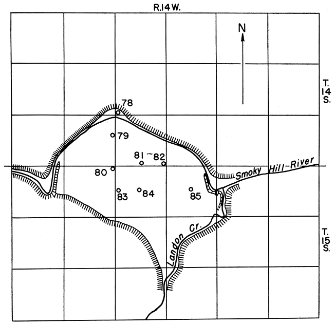
In the area south of test hole 80 there is very little saturated material. Part of the water that falls on this area as precipitation moves downward to or nearly to bedrock and then moves in the direction of the slope of the bedrock surface. The relatively steep slope of the bedrock causes the ground water to move away toward the north about as fast as additional water is received from precipitation or as seepage from the Cretaceous rocks. For this reason, the water table does not rise appreciably following rains, and the thickness of the saturated material remains small. The alluvium in this area, therefore, would yield only small quantities of water to a few domestic and stock wells.
Because of the northward movement of the water and the continued replenishment by precipitation, the water in the alluvium in the southern part of this area has a relatively low chloride content.
An example of the poor water-bearing properties of the alluvium in the southern part of the area is afforded by a well 200 feet southwest of test hole 83. This well was drilled through the alluvium and into the Graneros shale. About 15 minutes after a few gallons of water had been pumped from the well, the water level was about 6 feet below its level just before pumping began, and was about 3 feet below the base of the alluvium. Thus, in 15 minutes not enough water had moved from the surrounding alluvium into the well to replace the water that had been pumped out. Further evidence as to the poor ground-water conditions in the southern part of the area is the fact that test holes 81 and 85 failed to encounter water.
The alluvium in the southern part of the area lies on Graneros shale. The contact between these formations is exposed at both the east and west ends of this area, as shown by hachures on Figure 8. At the west end the base of the gravel is 38 feet above the water level in Smoky Hill River and at the east end it is 40 feet above the river level. This indicates that the alluvium in the eastern and western parts of this area contains little or no water.
The alluvium between test hole 80 and the bluffs of Cretaceous rocks at the north is thicker than it is in the southern part of the area. In the north, however, the alluvium has been deposited on sandstone of the Dakota formation and the water in the lower part of the alluvium is being contaminated by salt water from those beds. The saturated upper part of the alluvium between test hole 80 and the river is not of sufficient thickness to yield even a supplementary supply of ground water for the City of Russell. In addition, the water has a relatively high chloride content, and heavy pumping would accelerate the movement of salt water from the Dakota formation upward into the alluvium.
The old channel of Smoky Hill River was cut adjacent to the bluffs in the northernmost part of the area, where test hole 78 encountered 45.2 feet of saturated sand, gravel, and silt. The area in which such a thickness of saturated material occurs is relatively small. Wells in this part of the area probably would not supply all the water needed by the City of Russell, but could supply adequate water for supplementary use. However, the chloride content of the ground water here is 200 parts per million, and heavy pumping would cause salt water to move in from the Dakota formation and from the Smoky Hill River.
The water table in this area slopes toward Smoky Hill River; hence, ground water in this area is discharging into the river. Heavy pumping in the vicinity of test hole 78, however, would cause a lowering of the water table around the well. This lowering would create a water-table slope from the river toward the well, and the river then would contribute part of its salt water to the ground-water reservoir and thus to the wells.
Smoky Hill Valley south of Gorham--Test hole 86 was drilled in the Smoky Hill Valley near the Gorham bridge, in the NW cor. sec. 20, T. 15 S., R. 15 W. The drill penetrated sand containing gravel and silt and encountered the Dakota formation at a depth of 35 feet. The chloride content of the water from the Dakota formation was 1,305 parts per million and the chloride content of water from the alluvium was 1,290 parts per million. The alluvium in this locality has been deposited in a channel that has been cut into the Dakota formation, and salt water from the Dakota formation has contaminated the water in the alluvium.
The river valley at the Gorham bridge is about 0.3 mile wide. The saturated material, which is 21 feet thick at test hole 86, is composed mostly of sand containing gravel and silt. Therefore, properly spaced and properly constructed wells in this area probably would yield enough water for a supplementary supply for the City of Russell. The valley becomes very narrow a short distance above the bridge, and the river meanders from one bluff to the other. The pumping of wells in this area would lower the ground-water level considerably, causing the water table to slope from the river toward the well. The river would then contribute water to the ground-water reservoir.
Smoky Hill Valley south of Walker--Test hole 87 was drilled in the NE sec. 28, T. 15 S., R. 16 W., in Ellis County. The drill encountered chiefly sand and gravel before entering the Graneros shale at a depth of 48 feet. Water from the lower part of the alluvium had a chloride content of 1,200 parts per million.
Altitudes determined on the top of the Jetmore chalk member of the Greenhorn limestone and on the land surface at the test hole indicate that the drill entered the Graneros shale 15 or 20 feet above the top of the Dakota formation. The high chloride content of the water in the alluvium in this area probably has been caused either by percolation of salt water from the Dakota formation (the lower part of the Graneros shale may be sandy at this point) or by pollution from near-by improperly cased oil-test wells.
The saturated part of the alluvium at test hole 87 is 33 feet thick and consists mostly of gravel and sand, and the valley in this area is about a quarter of a mile wide. If surface water were used whenever possible, properly constructed wells in the alluvium probably would yield enough water to supply the city's needs during low stages of the river; but the quality of the water would not be satisfactory.
Smoky Hill Valley at Pfeifer--Test holes 88 and 89 were drilled near the Pfeifer bridge in T. 15 S., R. 16 W., Ellis County. The drill encountered 17 feet of saturated sand and gravel in test hole 88, and 32 feet of saturated sand and gravel in test hole 89. The chloride content of water from these two holes was 90 parts per million and 44 parts per million, respectively. In this area the alluvium of Smoky Hill River is underlain by the entire thickness of Graneros shale, which serves as an effective seal and prevents pollution of water in the alluvium by salt water from the underlying Dakota formation. An analysis of water from test hole 89 is given in Table 6.
The Smoky Hill Valley at Pfeifer is about a quarter of a mile wide. The ground-water reservoir is recharged mainly by precipitation in the valley near Pfeifer. Part of this water moves downward through the sandy soil to' the water table and tends to increase the thickness of saturated material. As the water table rises there is a resultant slope toward Smoky Hill River, causing the ground water to move toward and into the river. The amount of ground water discharged into the river annually probably is about equal to the amount of water added to the ground-water reservoir by precipitation.
If properly constructed wells were put down in this area they probably could obtain a relatively large quantity of water from the alluvium. As a result the water level would decline and the water table would slope toward the south away from the river. The water that is added to the ground-water reservoir would no longer be discharged into the river but would be utilized by the wells. Smoky Hill River would then become a losing stream, as it would contribute water to the ground-water reservoir, and it would thus help to supply the wells. The river probably would contribute much more water to the ground-water reservoir than would be added by recharge from precipitation.
Table 6--Analysis of water from test hole 89, Ellis County, Kansas Analyzed by Howard A. Stoltenberg, Kansas State Board of Health
| Constituent | Parts per million |
|---|---|
| Calcium (Ca) | 174 |
| Magnesium (Mg) | 28 |
| Sodium (Na) | 52 |
| Bicarbonate (HCO3) | 292 |
| Sulfate (SO4) | 345 |
| Chloride (Cl) | 44 |
| Fluoride (F) | 0.5 |
| Nitrate (NO3) | 1.3 |
| Total dissolved solids | 791 |
| Total hardness as CaCO3 | 549 |
| Carbonate hardness as CaCO3 | 240 |
| Noncarbonate hardness as CaCO3 | 309 |
A group of properly spaced and properly constructed wells in this area probably would supply sufficient water of acceptable quality to supply the city during periods when surface-water supplies are not usable, but probably would not supply the entire needs continuously. Before a definite decision is made regarding this area, however, it would be desirable to construct a test well and conduct a pumping test in order to determine the permeability of the water-bearing material, the proper spacing of proposed wells, and the optimum yield of each well.
Big Creek Valley south of Gorham--Test hole 90 was drilled in Big Creek Valley south of Gorham, in the NE SE sec. 30, T. 14 S., R. 15 W., on the south side of Big Creek. The drill penetrated 19 feet of surficial material before encountering the Greenhorn limestone. Water from this test hole, taken between depths of 14 and 19 feet, contained 550 parts per million of chloride.
The static water level at the test hole was 15.1 feet below the land surface, indicating that the saturated part of the alluvium was only 3.9 feet thick. The alluvium in this locality would yield very little water to wells. As the width of the valley is about 2,000 feet, further test drilling might reveal a greater thickness of saturated material in some other part. Because of the high chloride content of the water, however, no additional drilling was done in the area in 1944.
Area near Fossil Creek reservoir--Test holes 91 and 92 were drilled in the NE sec. 3, T. 14 S., R. 14 W., near the city reservoir on Fossil Creek. The holes penetrated surficial silt and sand and encountered the Greenhorn limestone at depths of 17 and 33 feet, respectively. These test holes encountered little or no water above the Cretaceous bedrock.
The surficial deposits that overlie the Cretaceous bedrock in these upland areas are relatively thin and contain little or no water. The material in many places is made up largely of fragments of limestone, chalk, and shale, derived from Cretaceous rocks, and is relatively impermeable. In addition, most of these deposits are present in small areas that are nearly surrounded by streams or draws that have been cut through the surficial deposits into the bedrock, and thus have drained the water from the surficial deposits nearly as fast as they could be recharged by precipitation. The thickness of the saturated material remains small and therefore the deposits are capable of yielding very little water to wells.
Conclusions--In his report of 1944 McLaughlin gives the following conclusions in regard to the availability of a water supply from wells for the City of Russell.
- The Cretaceous formations would not yield enough water for the City of Russell, and in many places parts of these formations contain salt water, particularly the Dakota formation.
- The surficial deposits, such as those on the upland areas near the impounding reservoir on Fossil Creek, are relatively thin and would yield little or no water to wells.
- The alluvium in that part of Big Creek Valley accessible to the City of Russell probably would not yield enough water for the total needs of the city. -The thickness of saturated material is small, the valley is narrow, and the water is somewhat salty. Farther west, in the vicinity of Hays, however, the valley is considerably wider and the chloride content of the water is much lower.
- In the Smoky Hill Valley below Pfeifer the alluvium at several places probably would yield enough water for at least a supplementary supply for the City of Russell. Below Pfeifer, however, the water in the alluvium has been contaminated by salt water from the Dakota formation and by oil-field brines.
- In the Smoky Hill Valley in the vicinity of Pfeifer the alluvium probably would yield adequate water for the City of Russell during parts of each year. However, it would be advisable for the city to obtain most of its water supply from Smoky Hill River whenever practicable because water in the river generally is much softer, as indicated by many analyses of the city water, than is the ground water at Pfeifer; and also because continuous heavy pumping might cause excessive lowering of the groundwater level. The city could obtain most of its supply from the river, except during low stages of the river, at which time ground water could be used.
Test drilling should precede the construction of wells, in order to find the best water-bearing materials and in order to determine the proper slot size for well screens and the depths at which the casing should be perforated. Test drilling should also indicate whether or not the well should be gravel-walled, and if so, the proper size of gravel that should be used in order to obtain maximum efficiency.
The wells should be widely spaced in order to prevent local overdevelopment of the ground-water reservoir, and if possible the optimum spacing and yield per well should be determined by conducting a pumping test on a preliminary well.
If a well field is developed in this area, periodic analyses of the river water and of ground water at strategic points above the well field should be made in order to detect at an early date any contaminated water that might be moving toward the well field from present or future oil-field developments.
Prev Page--Geology || Next Page--Conclusions, References
Kansas Geological Survey, Geohydrology
Placed on web Sept. 20, 2016; originally published Dec. 15, 1948.
Comments to webadmin@kgs.ku.edu
The URL for this page is http://www.kgs.ku.edu/Publications/Bulletins/76_6/04_gw.html