Kansas Geological Survey, Bulletin 70, Part 1, originally published in 1947
Originally published in 1947 as Kansas Geological Survey Bulletin 70, Part 1. This is, in general, the original text as published. The information has not been updated.
This report gives results of a detailed study of the coal reserves in Kansas; it includes data on the proved and potential reserves by beds and by counties of all bituminous coal beds in the state. Brief descriptions of coal-bearing groups of rocks with their interbedded coals are given as well as a short description of methods used in calculating the reserves. The proved coal reserves in Kansas are about 949,323,000 tons. The state's potential coal reserves are about 17,574,000,000 tons.
Coal ranks fourth among the mineral resources of Kansas. The cumulative production in the state compiled from records of the U. S. Bureau of Mines and the State Mine Inspection Department to the end of 1945 is 251,596,368 tons. The proved coal reserves in Kansas are calculated to be about 949,323,000 tons and are sufficient to last 250 years if mined at the average rate of production for the 5-year period 1940-1944. The proved coal reserves in Kansas include 60,000,000 tons which can be produced by strip-mining methods under present conditions. The coal produced in 1945 by strip-mining methods was 2,904,990 tons; therefore, the present rate of strip-coal production can be maintained under the present mining conditions for a period of about 30 years. The coal produced in 1945 by shaft or underground mining methods was 303,504 tons. The state's potential coal reserves are about 17,574,000,000 tons.
Figure 1--Map of eastern Kansas showing distribution of coal-beariing groups of strata.
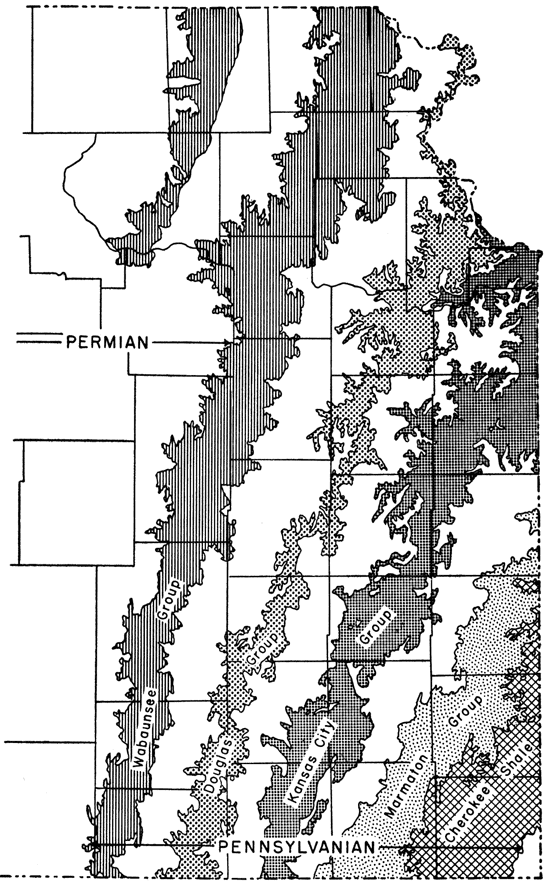
Present coal mining is restricted to the eastern part of the state (Fig. 1) where the coal beds occur at the surface or at comparatively shallow depths. Production of coal comes mainly from the following three areas: (1) the Southeastern Kansas field, which includes Labette, Cherokee, Crawford, Bourbon, and Linn counties; (2) the Osage field, in Osage and Coffey counties; and (3) the Leavenworth field, in Leavenworth County. The greatest amount of coal--88 percent--is obtained by stripping methods, whereas only 12 percent is shaft or deep mine coal. All commercial coal mined at present in Kansas is Pennsylvanian in age. Many of the coal beds that occur at the surface or at comparatively shallow depths are too thin to be of commercial importance at the present time; therefore, the actual mining areas or coal fields comprise only a relatively small part of the outcrop area of the coal-bearing rocks. A small amount of Permian coal was formerly mined in Wabaunsee County and about 200,000 tons of Cretaceous lignite have been obtained from the north-central part of the state. The lignite deposits of central Kansas are now being studied by the Geological Survey.
This report presents data on the proved and potential coal reserves of Kansas by beds and by counties. All bituminous coal beds in the state are treated. Brief descriptions of coal-bearing groups of rocks with their interbedded coals are given, as well as a short description of methods used in calculating the reserves.
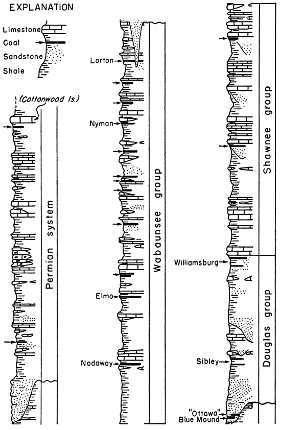
All bituminous coal reserves in Kansas, with the exception of 40,000 tons of proved reserves in Permian rocks, occur in five of the 10 groups of rocks assigned to the Pennsylvanian System (Fig. 2). The groups, named in the order of their proved coal reserves, are Cherokee, Wabaunsee, Marmaton, Kansas City, and Douglas. These strata contain at least 53 beds of coal, of which 14 are being mined at present. In former years some other Pennsylvanian coal beds were mined also.
Figure 2--Generalized geologic column of coal-bearing rocks of Kansas.
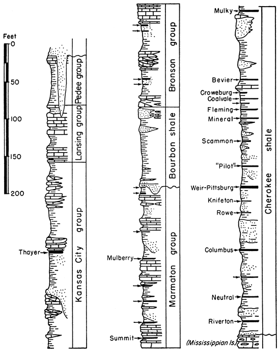
The Cherokee shale is the oldest group of coal-bearing rocks in Kansas and includes the Pennsylvanian rocks between the base of the Fort Scott limestone and the upper unconformable surface of the Mississippian. rocks. It consist of light- and dark-colored shale, sandy shales, sandstones, at least 14 beds of coal, and a few thin beds of limestone. The thickness of the Cherokee shale in areas of the coal reserves of southeastern Kansas ranges from 280 to 500 feet.
Rocks of the Cherokee shale crop out in a broad band in southeastern Kansas extending from eastern Labette County to southeastern Bourbon County. Of the coals in the Cherokee shale, 12 have been mined and 9 are commercially important. The most economically important beds are the Weir-Pittsburg, Mineral, Bevier, and Mulky. The coal beds of the Cherokee, named in ascending order, are Riverton, Neutral, Columbus, Rowe, Knifeton, Weir-Pittsburg, "Pilot," Scammon, Mineral, Fleming, Coalvale, Croweburg, Bevier, and Mulky. These beds range in thickness from very thin beds to the thick. Weir-Pittsburg bed, which locally attains a thickness of 60 inches. The coal beds of the Cherokee group have been discussed by Pierce and Courtier (1937) and by Abernathy (1946).
The Riverton coal lies below the Little Cabin sandstone member and is normally 5 to 20 feet above the base of the Cherokee shale in the area of its outcrop. It ranges from 3 to 14 inches in thickness and has been mined locally in the area of its outcrop in Cherokee County.
The Neutral coal consists of two beds, each about 10 inches thick, separated by about 3 feet of clay. The coal is known to occur only in its outcrop area in southern Crawford and northern Cherokee counties where it has been mined for local use.
The Columbus coal ranges in thickness from 6 to 14 inches. It underlies the Bluejacket sandstone and lies about 200 feet above the base of the Cherokee shale. It is mined locally by strip mines in Cherokee County.
The Rowe coal consists of an upper 14-inch bed, which is separated from the lower 4-inch bed by about 2 inches of clay-shale parting. This coal crops out east and south of Pittsburg in Crawford and Cherokee counties. It has been mined locally on a small scale for many years; however, recent exploration has proved a large area of commercial coal.
The Knifeton coal, about 7 inches thick, occurs about 14 feet above the Rowe coal. It has been mined locally in Crawford County but is not commercially important.
The Weir-Pittsburg bed ranges in thickness from 34 to 60 inches. It is the thickest and has supplied more coal than any other coal bed in the state. The interval from the Weir-Pittsburg coal to the base of the Cherokee shale ranges from 175 to 250 feet, and the interval to the top of the Cherokee shale ranges from 200 to 275 feet. This coal, which has also been called the "Cherokee bed" and the "Lower bed," crops out from the state line east of Arcadia in Crawford County to 2 miles north of Columbus in Cherokee County, a distance of about 50 miles. The coal bed dips northwest about 20 feet to the mile. In Montgomery County the coal lies at a depth of about 600 feet and in Leavenworth County it is more than 1,100 feet deep. The bed has large reserves in Leavenworth, Crawford, Cherokee, Labette, and Montgomery counties. The reserves of this bed of coal were estimated to be 233,383,000 tons in 1925 from an original total reserve of 295,622,000 tons (Young, 1925, p. 21). Recent work indicates the present proved reserves of this bed of coal to be 362,660,000 tons, and the potential reserves to be 4,128,000,000 tons. At the present time most of the coal produced from this bed is by stripping methods. In 1945, a total of 538,645 tons of coal was produced from the Weir-Pittsburg bed.
The Mineral coal bed has been called the "Upper Weir-Pittsburg," "Twenty-two Inch," and "Upper Cherokee" and has been erroneously known as the "Lightning Creek." The bed lies about 65 or 80 feet above the Weir-Pittsburg coal. In the outcrop area and near-by areas in Crawford, Cherokee, Labette, and Montgomery counties, the coal bed ranges in thickness from 18 to 24 inches and has an average thickness of 22 inches. More coal is currently being produced from this bed than from any other bed in the state. A few shallow shaft mines have produced coal from this bed; however, practically all of the production is obtained by strip-mining methods. The annual production of coal from this bed is more than 1,000,000 tons.
The Fleming coal bed is extremely variable in thickness and occurrence. Where present, the bed commonly lies 10 to 20 feet above the Mineral coal and has an average thickness of about 12 inches in its outcrop area in Crawford and Cherokee counties.
The Croweburg coal, which lies about 25 feet above the Mineral coal, has an average thickness of about 12 inches. The coal has been called "Fireclay," "Huntsinger," and "Mud Seam." The coal bed is commonly overlain and underlain by beds of typical underclay commonly called "fireclay." The coal bed is also commonly associated with a band of large black siliceous limestone concretions, 18 inches to 36 inches in diameter, which lie only a few feet above the coal bed.
The Bevier coal bed is known locally as the "Drywood Seam," "Pioneer Seam," "Limestone Bed," and "Lightning Creek Bed." The Bevier coal has an average thickness of about 18 inches and lies just above the Ardmore limestone, which is commonly about 100 feet below the top of the Cherokee shale. In Kansas, the Bevier coal now ranks second in importance in annual production. Its outcrop area is in Crawford and Cherokee counties. The Bevier coal has been mined by deep-mining methods in Leavenworth County, where it lies at a depth of about 750 feet and ranges in thickness from 19 to 22 inches.
The Mulky coal bed lies 3 to 5 feet below the top of the Cherokee shale. Its average thickness in the outcrop area ranges from 8 to 12 inches. It is variable in thickness and occurrence. The coal is locally called "Bunker Hill," "Fort Scott," and "Red" coal. It has been extensively mined by stripping in southern Bourbon and northern Crawford counties.
The Marmaton group of rocks consists of approximately 250 feet of shale, limestone, sandstone, and several beds of coal.
The Summit coal, where present, lies in the Little Osage shale member of the Fort Scott limestone. It is persistent from northern Crawford County northeastward into Missouri, but it is not commercially important in Kansas. There are several thin noncommercial coal beds in the Labette shale.
The Mulberry coal bed occurs in the lower part of the Bandera shale, only a few feet above the Pawnee limestone. The coal ranges in thickness from 5 inches in the southern part of Bourbon County to 40 inches in northern Linn County. The bed commonly contains a seam of pyrite or a layer of flat pyrite nodules or concretions which lies about 15 inches above the base of the coal. It is mined in Linn County.
The Kansas City group consists of approximately 275 feet of strata, of which about 70 percent is shale and sandstone and 30 percent is limestone (Fig. 2). The only coal of commercial importance occurring in the group is the Thayer coal in the Chanute shale. This bed ranges in thickness from a thin streak to about 29 inches. One to three clay or shale partings separate the coal into distinct layers, although where mined the coal most commonly consists of two beds. The coal is overlain everywhere by sandstone or shale and is underlain by shale. Mining activities of the Thayer bed are in the vicinity of Thayer in Neosho and Wilson counties. The Thayer coal bed has been discussed by Schoewe (1944).
Rocks of the Douglas group crop out from Atchison and Leavenworth on the Missouri River to Chautauqua County. Several relatively thin beds of coal are included in these rocks and at least six have been mined. The proved reserves, 15,886,000 tons, occur in the Blue Mound, Lower and Upper Sibley, and Lower and Upper Williamsburg beds (Tables 2 and 3). Potential reserves, amounting to 41,000,000 tons (Tables 4 and 5), are included in the same beds and in the "Ottawa" bed. The coal resources of the Douglas group have been discussed by Bowsher and Jewett (1943).
The Blue Mound coal crops out in Douglas County 6 to 8 miles southeast of Lawrence near Blue Mound and Sibley. The maximum known thickness of the bed is about 14 inches. The coal has been used as locomotive fuel and is of fair quality.
The "Ottawa" coal is at about the same stratigraphic positions as the Blue Mound coal (Fig. 2), and occurs southwest of Ottawa, Franklin County. The maximum thickness is probably not more than 10 inches.
The Sibley coals are regarded as minable in Leavenworth County where the lower seam has a maximum known thickness of 13 inches and the upper bed 20 inches.
The Williamsburg coal beds are minable in Franklin, Osage, Coffey, Anderson, Greenwood, and Woodson counties. The Upper Williamsburg coal has been mined more extensively than have the other coals in Douglas rocks. Most of the operations have been near Williamsburg and Ransomville, Franklin County. The maximum known thickness of the upper bed is about 26 inches.
The Wabaunsee group, the youngest or uppermost group of Pennsylvanian strata in Kansas, includes about 500 feet of shale, sandstone, and limestone. There are at least 12 coal beds in this group (Fig. 2), of which the lowermost or Nodaway coal is at the present time the only one of commercial importance. At least five coals--the Nodaway, Cedar Creek coal in the Willard shale, an unnamed coal in the Wamego shale, Nyman, and Lorton--are known to have been mined. The other coals are thin and unminable.
The Nodaway coal occurs in the basal part of the Howard limestone formation and has been traced almost continuously across the entire north-south width of the state along the strike of the Howard limestone formation from Doniphan and Nemaha counties to the Kansas-Oklahoma state line in Chautauqua County. The Nodaway coal has been mined in Atchison, Doniphan, Nemaha, Jefferson, Shawnee, Osage, Coffey, Elk, and Greenwood counties. The coal consists of a single bed and ranges in thickness from a streak to 36 inches, averaging 18 inches. Although formerly mined extensively in 10 counties in eastern Kansas, the Nodaway coal today is mined commercially only in Osage and Coffey counties.
The Elmo coal is next in importance. This coal occurs in the upper part of the Cedar Vale shale and can be traced from northeastern Brown County to the Kansas-Oklahoma state boundary in Chautauqua County. The Elmo coal ranges from less than 1 inch to about 30 inches in thickness, averaging 16 inches in Brown and Shawnee counties, 17 inches in Atchison County, and 18 inches in Chautauqua County. The coal does not occur everywhere as a single bed but in all other respects is similar to the Nodaway coal.
Other Wabaunsee group coals formerly mined include the Cedar Creek coal in the Willard shale, Cowley County; "Blacksmith Creek" coal in the Wamego shale, Shawnee County; Nyman coal in the Langdon shale, Lyon County; and Lorton coal in the French Creek shale in Lyon, Greenwood, Pottawatomie, and Wabaunsee counties. Wabaunsee group coals have been discussed by Schoewe (1946).
Proved reserves of the Wabaunsee group coals total 186,750,000 tons, and potential coal reserves amount to 3,685,000,000 tons.
Permian coal has been mined in the NE sec. 8, T. 14 S., R. 13 E., Wabaunsee County. The coal occurs in the Hawxby shale formation, Admire group, Wolfcampian Series (Fig. 2). The coal is 17 to 34 inches thick, has a high ash content, burns sootless, and has no block seams.
A 6-inch coal bed occurs about 9 feet below the top of the Eskridge shale in the NW cor. sec. 30, T. 1 S., R. 15 E., Brown County. This coal, however, is too thin to be mined. Another 12-inch bed of coal occurs in somewhat higher Permian rocks in sec. 17, T. 12 S., R. 7 E., Geary County.
Lignite occurs in the upper 35 feet of the Dakota formation and is known to be present in 14 central Kansas counties. It was formerly mined in Cloud, Ellsworth, Jewell, Lincoln, Mitchell, Republic, and Russell counties. The lignite ranges from 10 to 40 inches in thickness. Reserves are at present being studied by the State Geological Survey.
This report was compiled in December, 1945, and revised in 1946 from data collected by the State Geological Survey over a period of several years and from drilling records made freely available to the Geological Survey by most of the major coal mining companies operating in Kansas, and especially the Pittsburg and Midway and the Mackie Clemmens Coal Mining Companies. Records of the Mine Inspection Division of the State Department of Labor were made available to the Survey for use in this study.
The coal reserves of Kansas are divided into proved and potential reserves. The proved coal reserves are shown by counties in Table 2 and by beds in Table 3. The potential coal reserves are shown by counties in Table 4 and by beds in Table 5.
Since no procedure for calculating proved coal reserves has been generally accepted by the various operating companies and scientific agencies, a definite procedure was established by the State Geological Survey of Kansas for determining both the proved and potential coal reserves of the state. As used in this report, the proved coal reserve is coal that lies within arbitrary limits of thickness and distance from a known occurrence. These limits are based on the past experience of the industry and geological observations in Kansas. The potential reserve is determined by regional stratigraphic projection. The methods of computing coal reserves are briefly described below:
Table 1--Maximum depth to coal per minimum thickness of coal beds considered minable by underground methods in Kansas.
| Maximum depth to coal, feet |
Minimum thickness of coal, inches |
|---|---|
| 100 | 19 |
| 150 | 18 |
| 200 | 22 |
| 600 | 32 |
| 1,200 | 36 |
Table 2--Proved coal reserves by counties.
| County | Geological rock division |
Coal bed |
Coal reserves, in thousands of tons |
|
|---|---|---|---|---|
| Bed | County total | |||
| Atchison | Wabaunsee | Elmo | 9,906 | 21,266 |
| Wabaunsee | Nodaway | 1,410 | ||
| Douglas | Williamsburg1 | 1,920 | ||
| Cherokee | Miscellaneous | 8,030 | ||
| Bourbon | Marmaton | Mulberry | 8,320 | 22,000 |
| Cherokee | Mulky | 5,760 | ||
| Cherokee | Bevier | 7,920 | ||
| Brown | Wabaunsee | Elmo | 23,167 | 23,447 |
| Miscellaneous | 280 | |||
| Chautauqua | Wabaunsee | Elmo | 5,725 | 5,725 |
| Cherokee | Cherokee | Bevier | 14,080 | 160,160 |
| Cherokee | Fleming | 500 | ||
| Cherokee | Mineral | 47,620 | ||
| Cherokee | Weir-Pittsburg | 86,400 | ||
| Cherokee | Rowe | 4,800 | ||
| Cherokee | Columbus | 5,760 | ||
| Cherokee | Miscellaneous | 1,000 | ||
| Coffey | Wabaunsee | Nodaway | 11,324 | 11,324 |
| Cowley | Wabaunsee | Miscellaneous | 6,790 | 6,790 |
| Crawford | Cherokee | Mulky | 2,400 | 263,790 |
| Cherokee | Bevier | 21,120 | ||
| Cherokee | Croweburg | 1,000 | ||
| Cherokee | Fleming | 2,500 | ||
| Cherokee | Mineral | 126,590 | ||
| Cherokee | Weir-Pittsburg | 100,580 | ||
| Cherokee | Rowe | 9 ,600 | ||
| Doniphan | Wabaunsee | Nodaway | 3,984 | 3,984 |
| Douglas | Douglas | Blue Mound | 450 | 450 |
| Elk | Wabaunsee | Elmo | 2,016 | 3,240 |
| Wabaunsee | Nodaway | 1,224 | ||
| Franklin | Douglas | Williamsburg | 8,000 | 8,000 |
| Jackson | Wabaunsee | Elmo | 2,800 | 2,800 |
| Jefferson | Wabaunsee | Nodaway | 13,600 | 13,600 |
| Labette | Cherokee | Weir-Pittsburg | 146,880 | 146,880 |
| Leavenworth | Douglas | Sibley | 1,416 | 28,512 |
| Cherokee | Miscellaneous | 27,096 | ||
| Linn | Kansas City | Thayer | 300 | 54,691 |
| Marmaton | Mulberry | 54,391 | ||
| Lyon | Wabaunsee | Nodaway | 2,800 | 5,522 |
| Miscellaneous | 2,722 | |||
| Montgomery | Kansas City | Thayer | 9,800 | 38,600 |
| Cherokee | Weir-Pittsburg | 28,800 | ||
| Nemaha | Wabaunsee | Nodaway | 5,760 | 5,760 |
| Neosho | Kansas City | Thayer | 12,700 | 12,700 |
| Osage | Wabaunsee | Nodaway | 77,720 | 80,820 |
| Douglas | Williamsburg | 3,100 | ||
| Shawnee | Wabaunsee | Elmo | 3,953 | 15,522 |
| Wabaunsee | Nodaway | 10,289 | ||
| Wabaunsee | Miscellaneous | 1,280 | ||
| Wabaunsee | Permian | Unnamed bed in Hawxby shale |
40 | 40 |
| Wilson | Kansas City | Thayer | 12,700 | 12,700 |
| Woodson | Douglas | Williamsburg | 1,000 | 1,000 |
| (1) Bed tentatively identified as Williamsburg. | ||||
Table 3--Proved coal reserves by beds.
| Coal bed |
Geological rock division |
County | Coal reserves, in thousands of tons |
|
|---|---|---|---|---|
| County total | Bed total | |||
| Bevier | Cherokee | Bourbon | 7,920 | 43,120 |
| Cherokee | Cherokee | 14,080 | ||
| Cherokee | Crawford | 21,120 | ||
| "Blue Mound" | Douglas | Douglas | 450 | 450 |
| Columbus | Cherokee | Cherokee | 5,760 | 5,760 |
| Croweburg | Cherokee | Crawford | 1,000 | 1,000 |
| Elmo | Wabaunsee | Atchison | 9,906 | 47,567 |
| Wabaunsee | Brown | 23,167 | ||
| Wabaunsee | Chautauqua | 5,725 | ||
| Wabaunsee | Elk | 2,016 | ||
| Wabaunsee | Jackson | 2,800 | ||
| Wabaunsee | Shawnee | 3,953 | ||
| Fleming | Cherokee | Cherokee | 500 | 3,000 |
| Cherokee | Crawford | 2,500 | ||
| Mineral | Cherokee | Cherokee | 47,620 | 174,210 |
| Cherokee | Crawford | 126,590 | ||
| Mulberry | Marmaton | Bourbon | 8,320 | 62,711 |
| Marmaton | Linn | 54,391 | ||
| Mulky | Cherokee | Bourbon | 5,760 | 8,160 |
| Cherokee | Crawford | 2,400 | ||
| Nodaway | Wabaunsee | Atchison | 1,410 | 128,111 |
| Wabaunsee | Coffey | 11,324 | ||
| Wabaunsee | Doniphan | 3,984 | ||
| Wabaunsee | Elk | 1,224 | ||
| Wabaunsee | Jefferson | 13,600 | ||
| Wabaunsee | Lyon | 2,800 | ||
| Wabaunsee | Nemaha | 5,760 | ||
| Wabaunsee | Osage | 77,720 | ||
| Wabaunsee | Shawnee | 10,289 | ||
| Rowe | Cherokee | Cherokee | 4,800 | 14,400 |
| Cherokee | Crawford | 9,600 | ||
| Sibley | Douglas | Leavenworth | 1,416 | 1,416 |
| Thayer | Kansas City | Linn | 300 | 35,500 |
| Kansas City | Montgomery | 9,800 | ||
| Kansas City | Neosho | 12,700 | ||
| Kansas City | Wilson | 12,700 | ||
| Weir-Pittsburg | Cherokee | Cherokee | 86,400 | 362,660 |
| Cherokee | Crawford | 100,580 | ||
| Cherokee | Labette | 146,880 | ||
| Cherokee | Montgomery | 28,800 | ||
| Williamsburg1 | Douglas | Atchison | 1,920 | 14,020 |
| Douglas | Franklin | 8,000 | ||
| Douglas | Osage | 3,100 | ||
| Douglas | Woodson | 1,000 | ||
| Miscellaneous | Cherokee | Atchison | 8,030 | 36,126 |
| Cherokee | Cherokee | 1,000 | ||
| Cherokee | Leavenworth | 27,096 | ||
| Wabaunsee | Brown | 280 | 11,072 | |
| Wabaunsee | Cowley | 6,790 | ||
| Wabaunsee | Lyon | 2,722 | ||
| Wabaunsee | Shawnee | 1,280 | ||
| Unnamed bed in Hawxby shale |
Permian | Wabaunsee | 40 | 40 |
| (1) Bed tentatively identified as Williamsburg. | ||||
Table 4--Potential coal reserves by counties.
| County | Geological rock division |
Coal bed |
Coal reserves, in millions of tons |
|
|---|---|---|---|---|
| Bed | County total | |||
| Atchison | Wabaunsee | Elmo | 137 | 1,871 |
| Wabaunsee | Noclaway | 115 | ||
| Douglas | Williamsburg' | 3 | ||
| Cherokee | Miscellaneous | 1,616 | ||
| Bourbon | Marmaton | Mulberry | 317 | 764 |
| Cherokee | Mulky | 216 | ||
| Cherokee | Bevier | 216 | ||
| Cherokee | Croweburg | 15 | ||
| Brown | Wabaunsee | Elmo | 456 | 680 |
| Miscellaneous | 224 | |||
| Chautauqua | Wabaunsee | Elmo | 216 | 216 |
| Cherokee | Cherokee | Bevier | 58 | 949 |
| Cherokee | Fleming | 50 | ||
| Cherokee | Mineral | 141 | ||
| Cherokee | Weir-Pittsburg | 461 | ||
| Cherokee | Rowe | 130 | ||
| Cherokee | Columbus | 77 | ||
| Cherokee | Miscellaneous | 32 | ||
| Coffey | Wabaunsee | Nodaway | 15 | 15 |
| Cowley | Wabaunsee | Miscellaneous | 192 | 192 |
| Crawford | Cherokee | Mulky | 8 | 2,197 |
| Cherokee | Bevier | 331 | ||
| Cherokee | Croweburg | 77 | ||
| Cherokee | Fleming | 30 | ||
| Cherokee | Mineral | 751 | ||
| Cherokee | Weir-Pittsburg | 979 | ||
| Cherokee | Rowe | 21 | ||
| Doniphan | Wabaunsee | Nodaway | 47 | 47 |
| Douglas | Douglas | Blue Mound | 1 | 1 |
| Elk | Wabaunsee | Elmo | 259 | 331 |
| Wabaunsee | Nodaway | 72 | ||
| Franklin | Douglas | Williamsburg | 22 | 23 |
| Douglas | "Ottawa" | 1 | ||
| Greenwood | Wabaunsee | Miscellaneous | 62 | 62 |
| Jackson | Wabaunsee | Elmo | 191 | 191 |
| Jefferson | Wabaunsee | Nodaway | 132 | 132 |
| Labette | Cherokee | Mineral | 461 | 2,381 |
| Cherokee | Weir-Pittsburg | 1,920 | ||
| Leavenworth | Douglas | Sibley | 3 | 3,711 |
| Cherokee | Miscellaneous | 3,708 | ||
| Linn | Marmaton | Mulberry | 729 | 737 |
| Cherokee | Mulky | 8 | ||
| Lyon | Wabaunsee | Nodaway | 121 | 303 |
| Wabaunsee | Miscellaneous | 182 | ||
| Miami | Marmaton | Mulberry | 123 | 123 |
| Montgomery | Kansas City | Thayer | 170 | 961 |
| Cherokee | Mineral | 23 | ||
| Cherokee | Weir-Pittsburg | 768 | ||
| Nemaha | Wabaunsee | Nodaway | 269 | 269 |
| Neosho | Kansas City | Thayer | 25 | 25 |
| Osage | Wabaunsee | Nodaway | 270 | 276 |
| Douglas | Williamsburg | 6 | ||
| Pottawatomie | Wabaunsee | Miscellaneous | 160 | 160 |
| Shawnee | Wabaunsee | Elmo | 256 | 565 |
| Wabaunsee | Nodaway | 245 | ||
| Wabaunsee | Miscellaneous | 64 | ||
| Wabaunsee | Permian | Unnamed bed in Hawxby shale |
156 | 156 |
| Wilson | Kansas City | Thayer | 231 | 231 |
| Woodson | Douglas | Williamsburg | 5 | 5 |
| (1) Bed tentatively identified as Williamsburg. | ||||
Table 5--Potential coal reserves by beds.
| Coal bed |
Geological rock division |
County | Coal reserves, in millions of tons |
|
|---|---|---|---|---|
| County total | Bed total | |||
| Bevier | Cherokee | Bourbon | 216 | 605 |
| Cherokee | Cherokee | 58 | ||
| Cherokee | Crawford | 331 | ||
| Blue Mound | Douglas | Douglas | 1 | 1 |
| Columbus | Cherokee | Cherokee | 77 | 77 |
| Croweburg | Cherokee | Bourbon | 15 | 92 |
| Cherokee | Crawford | 77 | ||
| Elmo | Wabaunsee | Atchison | 137 | 1,515 |
| Wabaunsee | Brown | 456 | ||
| Wabaunsee | Chautauqua | 216 | ||
| Wabaunsee | Elk | 259 | ||
| Wabaunsee | Jackson | 191 | ||
| Wabaunsee | Shawnee | 256 | ||
| Fleming | Cherokee | Cherokee | 50 | 80 |
| Cherokee | Crawford | 30 | ||
| Mineral | Cherokee | Cherokee | 141 | 1,376 |
| Cherokee | Crawford | 751 | ||
| Cherokee | Labette | 461 | ||
| Cherokee | Montgomery | 23 | ||
| Mulberry | Marmaton | Bourbon | 317 | 1,169 |
| Marmaton | Linn | 729 | ||
| Marmaton | Miami | 123 | ||
| Mulky | Cherokee | Bourbon | 216 | 232 |
| Cherokee | Crawford | 8 | ||
| Cherokee | Linn | 8 | ||
| Nodaway | Wabaunsee | Atchison | 115 | 1,286 |
| Wabaunsee | Coffey | 15 | ||
| Wabaunsee | Doniphan | 47 | ||
| Wabaunsee | Elk | 72 | ||
| Wabaunsee | Jefferson | 132 | ||
| Wabaunsee | Lyon | 121 | ||
| Wabaunsee | Nemaha | 269 | ||
| Wabaunsee | Osage | 270 | ||
| Wabaunsee | Shawnee | 245 | ||
| "Ottawa" | Douglas | Franklin | 1 | 1 |
| Rowe | Cherokee | Cherokee | 130 | 151 |
| Cherokee | Crawford | 21 | ||
| Sibley | Douglas | Leavenworth | 3 | 3 |
| Thayer | Kansas City | Montgomery | 170 | 426 |
| Kansas City | Neosho | 25 | ||
| Kansas City | Wilson | 231 | ||
| Weir-Pittsburg | Cherokee | Cherokee | 461 | 4,128 |
| Cherokee | Crawford | 979 | ||
| Cherokee | Labette | 1,920 | ||
| Cherokee | Montgomery | 768 | ||
| Williamsburg1 | Douglas | Atchison | 3 | 36 |
| Douglas | Franklin | 22 | ||
| Douglas | Osage | 6 | ||
| Douglas | Woodson | 5 | ||
| Miscellaneous | Cherokee | Atchison | 1,616 | 5,356 |
| Cherokee | Cherokee | 32 | ||
| Cherokee | Leavenworth | 3,708 | ||
| Wabaunsee | Brown | 224 | 884 | |
| Wabaunsee | Cowley | 192 | ||
| Wabaunsee | Greenwood | 62 | ||
| Wabaunsee | Lyon | 182 | ||
| Wabaunsee | Pottawatomie | 160 | ||
| Wabaunsee | Shawnee | 64 | ||
| Unnamed bed in Hawxby shale |
Permian | Wabaunsee | 156 | 156 |
| (1) Bed tentatively identified as Williamsburg. | ||||
Abernathy, G. E., 1944, Mined areas of the Weir-Pittsburg coal bed: Kansas Geol. Survey, Bull. 52, pt. 5, pp. 213-228, fig. 1, pl. 1. [available online]
Abernathy, G. E., 1946, Strip-mined areas in the southeastern Kansas coal field: Kansas Geol. Survey, Bull. 64, pt. 4, pp. 125-144, fig. 1, pls. 1-3.
Allen, H. C., 1925, The chemistry of Kansas coal: Kansas Univ. Bull., vol. 26, no. 5, Div. Chem. Research, Bull. 4, pp. 127-202, pls. 1-3.
Bowsher, A. L., and Jewett, J. M., 1943, Coal resources of the Douglas group in east-central Kansas: Kansas Geol. Survey, Bull. 46, pp. 1-94, figs. 1-12, pls. 1-6. [available online]
Haworth, Erasmus, 1895, The coal fields of Kansas: Kansas Univ. Quart., vol. 3, no. 4, pp. 297-309.
Haworth, Erasmus, 1896, The coal fields of Kansas: Kansas Univ. Geol. Survey, vol. 1, pp. 218-231. (Abstract, Jour. Geology, 1896, pp. 645-646.)
Haworth, Erasmus, and Crane, W. R., 1898, Special report on coals: Kansas Univ. Geol. Survey, vol. 3, pp. 1-347, figs. 1-54, pls. 1-70.
Hay, Robert, 1889, Horizon of the Dacotah lignite: Kansas Acad. Sci., Trans., vol. 11, pp. 5-8.
Jewett, J. M., and Schoewe, W. H., 1942, Kansas mineral resources for war-time industries: Kansas Geol. Survey, Bull. 41, pt. 3, pp. 69-180, figs. 1-13.
Pierce, W. G., and Courtier, W. H., 1937, Geology and coal resources of the southeastern Kansas coal field in Crawford, Cherokee, and Labette counties: Kansas Geol. Survey, Bull. 24, pp. 1-122, figs. 1-13, pls. 1-12.
Schoewe, Walter H., 1944, Coal resources of the Kansas City group, Thayer bed, in eastern Kansas: Kansas Geol. Survey, Bull. 52, pt. 3, pp. 81-136, figs. 1-8, pls. 1-5. [available online]
Schoewe, Walter H., 1946, Coal resources of the Wabaunsee group in eastern Kansas: Kansas Geol. Survey, Bull. 63, pp. 1-144, figs 1-34, pls. 1-5. [available online]
U. S. Bureau of Mines, 1929, Analyses of Kansas coals: U. S. Bur. Mines, Tech. Paper 455, pp. 1-52, figs. 1-2.
Whitla, R. E., 1940, Coal resources of Kansas: Post-Cherokee deposits: Kansas Geol. Survey, Bull. 32, pp. 1-64, figs. 1-28, pls. 1-5. [available online]
Young, C. M., 1925, Kansas coal: occurrence and production: Kansas Univ. Bull., vol. 26, no. 5, Eng. Bull. 13, pp 13-123, figs. 1-29.
Kansas Geological Survey, Geology
Placed on web April 20, 2009; originally published in 1947.
Comments to webadmin@kgs.ku.edu
The URL for this page is http://www.kgs.ku.edu/Publications/Bulletins/70_1/index.html