![]()
Prev Page--Stratigraphy || Next Page--Oil and gas sands
Structure
Regional Structure
The regional structure of eastern Kansas was developed in post-Paleozoic time. It resulted from an uplift which had its center in the Ozark region of southeastern Missouri. The strata were tilted in such a manner that they now dip northwestward at the rate of 15 to 20 feet per mile. The great number of minor variations from the general dip include most of the common structural forms, such as anticlines, synclines, domes, and terraces.
Local Structure
The structure of the formations was determined by obtaining the elevations of the surface beds at many scattered points or by finding the elevation of some readily recognized bed penetrated by drilling, the elevation of the wells having previously been secured. The horizon used most often for the study of the subsurface structure is the top of the Iola limestone. The Iola is a very easily recognized formation of uniform occurrence, and nearly all the wells were started above it.
Typical structures in the county which at present have no production on them and structures which are productive only because of the coincidental occurrence of oil or gas under portions of them will be described here. Others will be described in the discussions of the fields in which they are located.
An anticline in the southwestern part of T. 20 S., R. 21 E., is the largest in the county. Its major axis extends from the southwest corner of sec. 16, T. 20 S., R. 21 E., to the middle of sec. 5, T. 21 S., R. 21 E., 11 distance of three and a half miles. The southern end of the structure terminates in a dome having a closure of 20 feet. A structural nose which projects northwestward from this anticline covers parts of secs. 18 and 19, T. 20 S., R. 21 E., and secs. 13 and 24, T. 20 S., R. 20 E. The Bush City shoestring touches the southeastern flank of this structure in the NW sec. 4, T. 21 S., R. 21 E. A very narrow gas pool has been opened in the SW sec. 16, T. 20 S., R. 21 E., and vicinity. Another narrow shoestring of gas wells about three-fourths of a mile long extends from the NE NE sec. 5, T. 21 S., R. 21 E., to the middle of sec. 32, T. 20 S., R. 21 E. It parallels and is slightly east of the major axis of the dome described as terminating the large anticline on the south. Numerous dry holes have been drilled on this anticline. With the exception of those in the productive areas mentioned, few of them found more than 5 to 10 feet of sand. A dry hole in the SW SE sec. 13, T. 20 S., R. 20 E., had a showing of heavy oil in sand from 755 to 766 feet. Two dry holes that reached the "Mississippi lime" are reported to have had only 5 feet of sand, and that was immediately on top of the "lime."
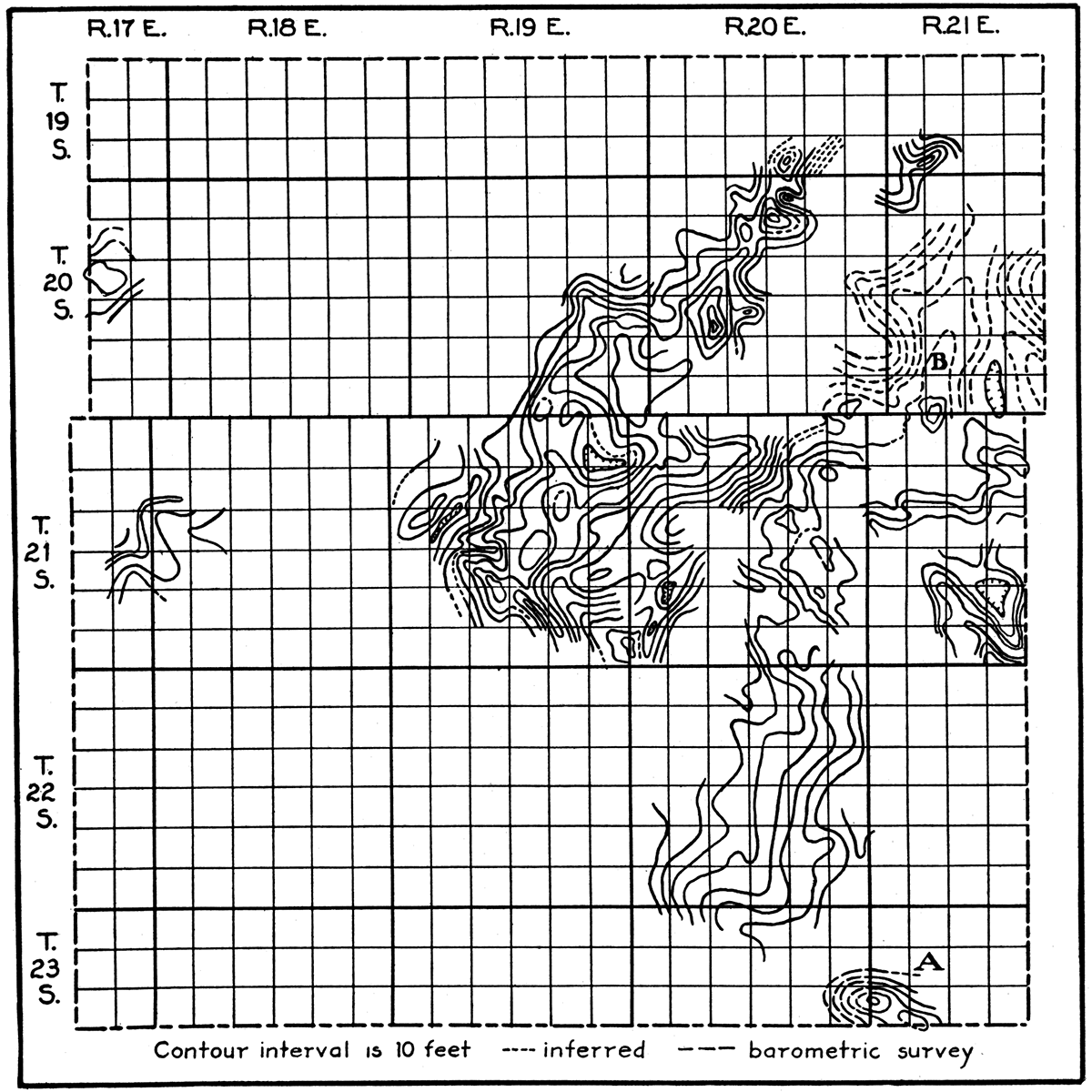
Figure 2—Surface structural map of Anderson County. The map demonstrates the unsystematic type of structure in the county. Contours are drawn on different limestone beds, chiefly the Iola and Plattsburg. A is believed to represent a structure caused by folding; B a structure caused by thinning of a shale member beneath the limestone used for datum. The map is a compilation of the work of several geologists and includes a large part of the area occupied by key beds. The regional dip is toward the northwest.
Along the west flank of the productive area between Garnett and Greeley is a series of small domes and anticlines separated by basins and synclines. The largest anticline, which has a closure of 30 feet, is in secs. 17, 20 and 29, T. 20 S., R. 20 E., a mile northeast of Garnett. The major axis extends north-south. Two dry holes have been drilled near the top and two on the south flank. The hole in the NW SE sec. 20 encountered sand from 642 to 663 feet that held a small amount of oil. More sand was logged from 760 to 765 feet.
A structure with closure of about 20 feet lies just west of Garnett in secs. 24, 25, 35 and 36, T. 20 S., R. 19 E. Its flanks dip gently from the apex which is in the N2 sec. 36. Several dry holes have tested the structure.
An almost circular dome about a mile in diameter and with a closure of 20 to 30 feet has its apex in the northeast corner of sec. 11, T. 21 S., R. 20 E. A dry hole in the southwest corner of sec. 2 was drilled to 1,045 feet and found only a few feet of "dry" sand.
Two and a half miles south of Kincaid and on the southern edge of the county is a very pronounced structure known as the Mildred dome. Its axis is oriented about N. 65° W. The steep-dipping flanks form a closure of at least 30 feet. Among the four dry holes on the dome is one in the southwest corner of the NW sec. 18, T. 23 S., R. 21 E., that was drilled through the "second break" in the "Mississippi lime." The hole filled with sulphur water at 1,232 feet. The three other wells had showings of heavy oil in the cherty zone on top of the Mississippian limestone.
Origin of the Local Structure
The origin of the minor structural features of Anderson County must be attributed to agencies which cause structures that are irregular in size and shape, which have no regular arrangement, and whose axes extend in no single general direction. The following agencies have been considered: (1) direct lateral compression, (2) uneven compaction, (3) uneven deposition, (4) folding influenced by sand bodies, (5) folding caused by readjustments in the deep, competent rocks.
Direct lateral compression—At one time the theory of direct lateral compression was a favorite for explaining the origin of folds in sedimentary strata. More recently it has come to be realized that lateral stresses are not transmitted long distances through relatively thin vertical sections of incompetent beds, such as thin limestones and shales. The competent beds of Anderson County are considered to include those below the Pennsylvanian formations. The rocks older than the Pennsylvanian are massive limestones and dolomites which rest upon a basement of very dense, hard crystallines. The Pennsylvanian strata are chiefly shales, separated by thin limestones, which, in their separate state, are mere shells in a general incompetent mass.
In examining the possibility of the formation of Anderson County folds by direct lateral compression, points of origin of the forces necessary to create them must be sought. The logical places to look for these are in the seats of disturbance nearest this district. These are found in the Ozark mountains of southeastern Missouri and the Ouachita, Arbuckle, and Wichita mountains of Arkansas and Oklahoma. The Ozark region was not the seat of sufficient force to wrinkle the rocks far from its borders (Merritt and McDonald, 1926). Sharp folding occurs in the competent beds about the Ouachita-Arbuckle-Wichita group of uplifts, but these folds die out in a comparatively short distance. The folds of central and northern Oklahoma and south-central Kansas are smaller, have different shapes, and have different orientation than those which might be caused by lateral pressure exerted directly from the mountainous regions. Anderson County is at least 200 miles from any of the areas of disturbance mentioned. It may be stated with certainty that incompetent beds would not be thrown into compressional folds at this distance by forces of the size shown to have been in operation. If the deep competent beds had been thrown into compressional folds, the surface strata should conform with them because they rest like a blanket on the firmer crystallines and are subject to all changes in elevation that appear in the latter.
Uneven compaction—Practically all sedimentary deposits undergo compaction after they are laid down. Many writers have discussed this subject on both its theoretical and practical sides. The latest and one of the best discussions, and one based on laboratory experiments, is by Hedberg (1926), who shows by quantitative studies that the amount of compaction of shale is related closely to the weight of overburden. Compaction, chiefly of muds, is most likely to show its effects over uneven land surfaces or over isolated sand bodies. According to evidence already accumulated from various sources, shales and their interbedded strata dip over old topography in conformity with the slopes of the buried surface, but at a lesser rate. The dips are from the high points, or hills, where the blanket of sediments is thinner and where total consolidation is less, toward the lower points, or valleys, where there is relatively more consolidation of the thicker sediments.
When the practical worker attempts to test this theory, he generally finds that its strength depends mostly on these conditions: (1) the amount and sharpness of relief of the buried surface; (2) the thickness of the overlying sediments (no doubt these sediments should preferably be strata which at one time were deeply buried, but because of erosion are now the small remaining portion of a once thick series); (3) a factor that is not directly associated with geology, but one to which the practical geologist is forced to give due recognition—the accuracy of well records.
For obvious reasons it can be understood why it is desirable that there be a relatively thin cover of sediments over the buried topography. The chief reason is that the effects of differential compaction become less apparent as the upward interval increases. Since the weight of overburden is an important cause of the amount of compaction, a condition favorable to the expected results of this process would provide for a remaining relatively thin cover of argillaceous sediments which had undergone the limit of gravitational compaction because of their position beneath a former great thickness of strata, since eroded.
If a thick cover of sediments is involved, there can be less expectation of finding dips that resulted from compaction, not only because these dips must necessarily become more gentle away from the buried surface, but also because the factor of time is brought in. As time goes on the likelihood of the dips remaining essentially as formed or reaching their extreme inclination would be lessened due to the increasing opportunities for the introduction of other geologic processes, such as the uneven deposition of sediments, the creation of unconformities, the deposition of sediments that varied laterally in character, and true folding, which, taken collectively, are as common (and generally more pronounced in their effects) as the process under consideration.
The examination of this theory depends largely on subsurface studies, which in turn are dependent on well records. The laymen who make these records invariably lack the personal interest in such duties that would insure accurate data. This circumstance is a tremendous handicap to the investigator and retards greatly the examination of the problem at hand, as well as many other problems.
The irregular surface of the Mississippian limestone is very attractive for the application of the theory of gravitational compaction to explain some of the structural features of eastern Kansas. Wells drilled to the "lime" show that the Mississippian floor beneath Anderson County has a gentle relief, like that of a land surface in the cycle of old age. The presence of sharp ridges, fault scarps, or steep-sided valleys is not suggested. It is believed that the relief amounts to no more than 125 feet. At one place a dip of 90 feet in a mile occurs, which is very much above the average in the county. The cross section in Plate III includes an area where the greatest amount of relief has been found. No conclusive evidence of reflection of the Mississippian erosional surface in the upper strata is furnished by this section. The writer thinks that differential settling over the uneven surface of the Mississippian limestone is responsible for only a few of the surface dips in this area, and that it has produced only those dips of a gentle type that would not be likely to attract attention.
The occurrence of different kinds of deposits at the same stratigraphic horizon may cause dips when consolidation takes place. Because sand consolidates less than shale, the upper surface of a sand body would undergo less vertical subsidence than the surface of an equal thickness of shale on the sides. The shale would dip away from the sand and the strata above would be inclined by the same settling process. Mindful of this settling, geologists have undertaken to determine favorable places to drill in regions of scattered sand deposits by making surveys of the surface rocks. Their primary purpose in such cases is not to find places structurally favorable for the accumulation of oil or gas—in the general sense of the word—but to discover sand bodies—reservoirs in which commercial deposits of petroleum or natural gas commonly collect.
The quality of the sand in Anderson County is a drawback to the uneven compaction theory as used to discover or trace sand bodies. The sand is very fine-grained. Portions of it are so fine as to be silty. Lenses of shale are included in many places. These characteristics induce compaction more nearly equal to that of clean shale than a clean, coarse-grained quartz-sand and therefore would tend to lessen the relief in the overlying sediments. The structure which supports this theory best is the anticline northwest of Welda occupied by the Polkinghorn gas field. This fold, for which the sand body may be responsible, is long and narrow, occurs directly over the sand, and its major axis parallels the trend of the sand. However, a somewhat similar structure only a short distance east of the productive one, and having the same orientation, has no sand under it. Moreover, the latter fades into normal dip where the sand is near its maximum thickness.
Folding influenced by sand bodies—The hypothesis that sand bodies influence folding is an outgrowth of the differential settling theory. It is argued that the beds of shale at the sides of a sand body would have an inclination away from it caused by differential settling between the sand and shale. With this initial inclination as an aid, horizontal forces would cause folding to take place over the foreign body in the shale. The forces called upon by this theory are supplied by movements in the competent basement rocks. Thin or very narrow sand deposits, such as beach sands or channel fillings, probably would not influence the conversion of lateral stresses into vertical ones. Sandbars, which have greater thickness in proportion to their width than the other kinds of sand deposits, might exercise an influence. Strong objections to this theory are that (1) the dips of the strata on the sides of the sand would not be steep enough to invite folding, (2) no horizontal forces would be in effect at the horizon of the sand deposits but only in the deeper rocks—the deeper folding would be in control and the upper beds would be bent without regard for the type of sediments they contained.
Uneven deposition—The uneven deposition of sediments is considered by the writer to be an important cause of some of the abnormal dips in Anderson County. Both the shale and limestone members of the Lansing formation vary considerably in thickness and some of the other Pennsylvanian rocks change in thickness, though not as radically as those of the Lansing. No unconformities are noticeable in the surface formations. (See descriptions of members of Lansing formation, pp. 19-22.)
The uneven deposition of shale may be caused by: (1) varying distances from the source of supply, (2) variations in the rate of supply of the sediments, (3) variations in the velocity of the transporting agent, (4) the unloading of material into a common area from more than one direction, (5) irregular distribution of the sediments by currents and waves.
In case sediments are brought into a quiet sea at a constant rate by a single stream, a lenticular deposit is formed which thins radially from its thickest portion near the shore. If the amount of material is decreased, the size of the deposit is decreased, probably most noticeably in the vertical dimension. If the velocity of the transporting agent is slowed up, the limits to which the material is carried are drawn in. If more than one transporting agent brings material to a place of deposition, the shape of the deposited loads has additional irregularities due to the interfingering or overlapping of sediments. Currents probably play an important role in the final disposition of muds by taking up the loads dropped by the rivers, and carrying them long distances to redistribute them. The sediment is scoured from some portions of the ocean floor and dropped at other points where the currents are checked or deflected. The result of all these conditions is a formation of uneven thickness.
In case a limestone is laid down on a gently sloping surface, such as that of a layer of mud, the limestone conforms itself to the relief of the mud, because it is deposited in the manner of a precipitate. After consolidation, the limestone has an inclination resembling that caused by folding. In many places in Anderson County the Plattsburg and Stanton limestones have dips that are traceable to changes in thickness of the Lane and Vilas shales. Such dips, when opposed to the regional dip, form "pseudo-structures." They are depositional features rather than true structural features and hold no significance in the search for oil and gas pools. One broad anticline in the county has 50 feet of reverse dip as mapped on the base of the Plattsburg limestone, but at least 40 feet of this dip may be accounted for by the thinning of the Lane shale from 150 to 110 feet.
Folding caused by readjustments in the deep, competent rocks—Some of the structures may have been formed as the result of readjustments in the deep, competent beds. It has been observed that the more prominent ones, those with relatively steeper dips, have about the same orientation—N. 30°-45° W. In Oklahoma there are systems of folds and faults arranged en echelon. Merritt and McDonald (1926) have explained the origin of these as the result of rotational stresses transmitted to the overlying incompetent rocks by shearing in the crystallines, giving rise to compressional anticlines and tension faults. It seems doubtful whether the same thrusts that caused the warpings and faults in Oklahoma were responsible for those in this part of Kansas. The scattered folds here that may be segregated into systems are fewer and have more variations in shape than the Oklahoma folds. Faults are very scarce and of inconsequential displacement. However, the fact that the folds decrease in sharpness and numbers and the faults become less numerous as they are followed northward, lends a faint suggestion that the same thrusting effect, originating somewhere in the southern Oklahoma region, was in play.
Moore (1918) has concluded that the "granite ridge" of central Kansas was formed by up-faulting in pre-Mississippian time, probably in the early part of the Paleozoic era. If movements of such magnitude were in play, their effect in the way of smaller movements can be expected to have reached as far east as the Anderson County area, 75 miles away. Movements along the lines of weakness created in earlier geologic time were renewed in later Paleozoic time, and perhaps in other eras.
The writer is not prepared to say whether these deep-seated- disturbances were of the "stress and strain" type that account for the Oklahoma folds, or were faults that fade into folds in the softer rocks near the surface. It is concluded, however, that some such deep-seated regional forces were involved in forming the true folds of this district.
Few data are available on the attitude of the deep rocks in eastern Kansas because only one well in several hundred has been drilled below the "Mississippi lime." A better understanding of conditions in the older rocks might furnish an interpretation of how the structures were formed.
In summary, the abnormal dips of the strata in Anderson County are believed to have been caused chiefly by thickening and thinning of the Pennsylvanian sediments, especially the members of the Lansing formation, and by readjustments in the deep, competent rocks. Differential settling over the Mississippian floor may be responsible for some of the very gentle dips. The writer recognizes the plausibility of the uneven compaction theory, but has not found sufficient evidence to convince him that the reflection of subsurface features in this district can be traced upward as far as the formations now exposed.
Accumulation of Oil and Gas
General Conditions
Oil and gas fields in areas of sheet sands have a close relationship to the structure of the rocks. If the sand contains water, the oil and gas are found on top of the water in the highest places in the reservoir. They become concentrated in the traps formed by the flattening or reversal of the dip of the rocks. Anticlines, domes, noses, and terraces are the most favorable types of structure on which to drill. Oil may settle into synclines or basins in case no water occupies the porous stratum. If the reservoir is partially water-filed, the oil rests on the surface of the water where it reaches up the flanks of the structure. This theory of the arrangement of gas, oil, and water, according to density, is known as the anticlinal, or structural theory. It is one of the basic principles which guides the petroleum geologist in his searches.
Not all wildcat wells located on structures are successful. The failures can be accounted for by the absence of one or more of the conditions whose collective effects are necessary to insure the successful application of the structural theory. Some of the reasons test wells are dry are; (1) the oil may never have been formed in the area being explored, (2) the absence of a suitable reservoir rock, (3) the lack of an impervious roof over the sand, such as a water-wet shale or a limestone, (4) the lack of sufficient pore space to allow the gas, oil and water to undergo gravitational separation, (5) the presence of avenues of escape for the oil furnished by faults or by exposure of the oil sand by erosion, (6) the surface structure is not a true reflection of the structure of the rocks in which the oil is expected; (7) drilling was not carried to a sufficient depth, (8) the structure may have been flushed free of its oil by circulating water, (9) heat furnished by igneous intrusions or the metamorphic action induced by sharp folding may have destroyed the oil.
Conditions in Anderson County
The structural theory of accumulation has only limited application in Anderson County, because (1) the sands have very scattered distribution, (2) the principal oil-bearing sand does not contain water, (3) the structure of the surface rocks is not always an indication of the structure below the surface.
The theory may be used with more confidence when dealing with the possible producing horizons in or below the Mississippian limestone. Conditions there warrant its application because the sands in these lower horizons are quite widespread and contain water. As yet they have not been found productive in this county, but sufficient tests have not been drilled in areas having the proper structural conditions to throw light on their possibilities.
The chief feature of the sands in this district, their scattered distribution, IS made more noticeable by the presence of trends of sand only a few hundred feet in width but several miles in length, and by many small disconnected bodies of sand. All the sands, except the main oil sand, contain salt water where they do not hold oil or gas. In every case the gas has migrated to the points where the reservoir rock has the highest elevation. In one place a body of one of the shallow gas sands extends over an anticline. On top of the structure the sand is occupied by gas—down the sides by salt water. (See Pl. VI.) The same relationship occurs in a small gas field near Garnett. Gas has been found in this sand where it crosses a dome. In a narrow trend of a deeper sand that yields gas in a continuous belt from Colony to a point near Mont Ida, production is cut off on each end by salt water. A major relationship between the sand and the regional dip has caused this separation of gas and water. The conditions may be illustrated as follows [Note: Credit for the recognition of such relationships between shoestring sand bodies and the regional dip is due John L. Rich.]: If a hollow glass tube were bent into the form of an arch and filled with gas and water, were sealed, and laid on a flat surface, there would be a slight separation of the contents, controlled by the diameter of the tube. If the surface on which the tube rested were tilted so that the convex side of the arch became the highest part, an appreciable difference in elevation would result between the ends and the middle of the reservoir. The gas would collect at the top of the arch or "anticline" so formed. The gas-producing area between Colony and Mont Ida is represented by the arch and the parts of the sand body which contain water by the ends of the tube. (See Fig. 9.) Recent development indicates that the same body of sand swings up the dip toward the northeast and again becomes high enough to be gas-bearing in an area a mile long.
The accumulation of gas may be controlled by the shape of a body of sand. This condition apparently holds true in a small gas pool in secs. 16, 17, 20 and 21, T. 20 S., R. 21 E. In this pool a narrow north-south group of gas wells produces from a bar-shaped ridge of sand. The top of the ridge is wide enough to allow for but one row of wells. Those drilled down the flanks of the ridge found it thinner, broken with shale, and water-bearing. In Fig. 3 contour lines on different horizons show the attitude of the beds. One plat indicates the distance of the top of the sand below the Fort Scott limestone and shows that the sand has in anticlinal form caused by lensing. The convex top of the reservoir rock serves the same purpose as a folded sheet sand, but it has the distinct disadvantage to the geologist and producer of not being reflected at the surface.
The chief oil sand contains no water and the limits of the sand define the limits of a field. Exceptions to this statement are found where apparently neither gas, nor oil, nor water are present. The manner in which the relative elevation and cleanness of this sand control the distribution of the gas and oil will be demonstrated in the discussion of the different fields. So far as the writer has been able to ascertain, surface structure has no significance in respect to the occurrence of this oil sand.
Prev Page--Stratigraphy || Next Page--Oil and gas sands
Kansas Geological Survey, Geology
Placed on web Feb. 6, 2018; originally published June 15, 1927.
Comments to webadmin@kgs.ku.edu
The URL for this page is http://www.kgs.ku.edu/Publications/Bulletins/6_7/04_struct.html