![]()
Prev Page--Start of County Data || Next Page--References
Wabaunsee Coal-Bearing Counties, Continued
Lyon County
Approximately half of Lyon County or the area east of a diagonal line drawn from the northeast to the southwest corners of the county is underlain by rocks belonging to the Wabaunsee group (Fig. 26). At least six coals crop out in this territory, of which the Nodaway, Nyman, and Lorton are definitely known to have been mined in the past.
Figure 26--Map of Lyon County, Kansas, showing location of coal mines and outcrops and traces of the Howard, Burlingame, and Brownville limestones.
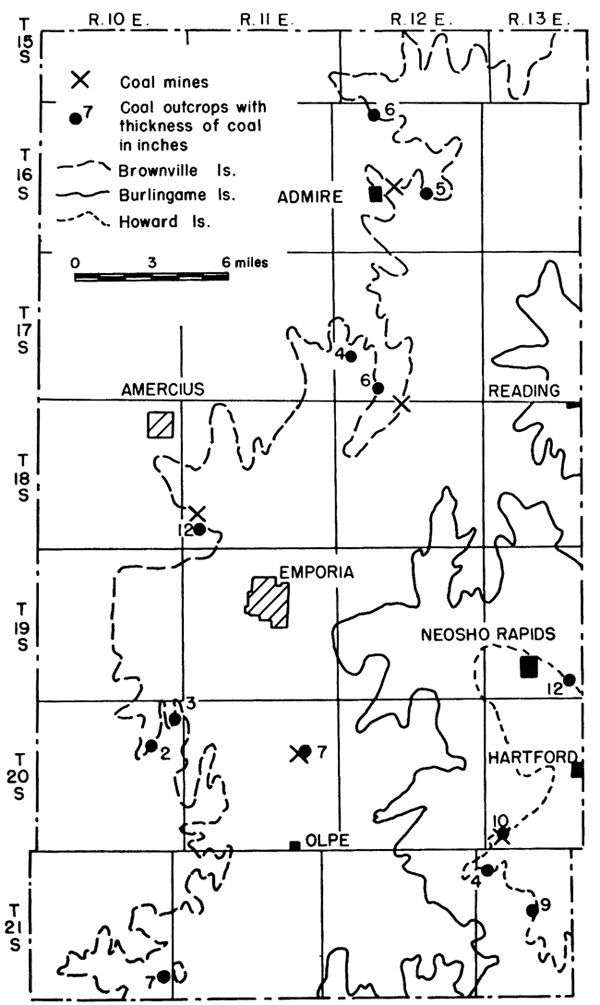
The presence of coal in Lyon County was known to the earliest settlers. Its occurrence is recorded by Swallow in 1866 (p. 56), and its mining for neighborhood use on Coal Creek, 10 miles southwest of Emporia, in the same year is noted by Mead (1901). As early as 1874 (Gray, 1875, p. 322) coal was mined in the vicinity of Neosho Rapids and south of Emporia on the banks of Eagle Creek, southwest of Hartford. Kelly (1887) refers to the finding of workable coal within the county as early as 1874 and the discovery of coal at several places in the northern part of the county, especially northeast and northwest of Emporia and near the town of Admire where a 17-inch seam of coal was found at a depth of 28 feet.
Nodaway coal
Nodaway coal crops out from Neosho Rapids south to the county line in R. 13 E. The coal is 12 inches thick near the SE cor. NE sec. 33, T. 19 S., R. 13 E., 1 mile south and 0.5 mile east of the southeast corner of Neosho Rapids, and 10 inches thick along the banks of Eagle Creek southwest of Hartford in the SE sec. 31, T. 30 S., R. 13 E. At the latter place the coal lies 24 inches below a 5-inch impure limestone, which is overlain by 24 inches of black shale and an 18-inch bed of Church limestone. The coal was mined at this locality along the face of the outcrop and by drifting as late as 1924. This coal was first mined in 1874 when it was known as the Eagle Creek coal. In the SW sec. 6, T. 21 S., R. 13 E., the Nodaway coal is only 4 inches thick; however, it thickens again to 9 inches in the NE cor. NW sec. 16.
Nyman coal
According to Smith (1903, p. 100), who identified four coal horizons in Lyon County, a 9-inch coal was stripped for local consumption on Coal Creek south of Emporia. The only possible locality where the coal could have been mined is at the N. line NW sec. 14, T. 20 S., R. 11 E. The coal, 5 to 7 inches thick, is overlain and underlain by shale and is 3.5 feet above creek level. The shale above the coal contains numerous pelecypods and crinoid stem fragments. This coal lies between the Reading and Dover limestones and is probably the Nyman coal in the upper part of the Wamego shale formation.
Lorton coal
Coal was formerly mined near the NE cor. SW sec. 30, T. 18 S., R. 11 E., several miles northwest of Emporia; in the NE cor. NW sec. 4, T. 18 S., R. 12 E., 9.5 miles northeast of the center of Emporia; and near the Cen. E. line sec. 21, T. 16 S., R. 12 E., 1 mile east of Admire. The coal at all three localities is a short distance below the Brownville limestone and is the Lorton coal. It is 6 inches thick in the NE cor. NW sec. 3, T. 16 S., R. 12 E., about 4 miles northeast of Admire, and 5 to 6 inches thick in the NE cor. SE sec. 32, T. 17 S., R. 12 E. The same coal is 9 inches thick near the Cen. NE sec. 9 and 9 to 12 inches thick 3 to 4 miles northwest of Emporia in the NE SW sec. 30, T. 18 S., R. 11 E., where it has been mined by stripping and drifting. Kelly (1887) reported the presence of four drift mines, the largest one of which was 175 feet long, near the Cen. sec. 30, and stated that the coal ranged in thickness from 11 to 17 inches. The mines were started in 1886. Coal was also mined by stripping at this locality.
The most important Lyon County mining district is that at Admire. According to Merle L. Sowell, formerly of Admire, the first coal mined in the Admire vicinity was stripped from the bed of 142 Mile Creek, 1 mile east and 0.25 mile north of the town. Between 1885 and 1890 three shallow shaft mines were operated east of this strip mine. Mr. Sowell estimated that about 4 to 5 acres of 16- to 20-inch coal were taken out by the early miners. In 1930 Sowell and his father sank a 25-foot shaft in the old workings of the No. 2 mine east of the creek. After mining about 500 tons of coal, the mines were flooded out and abandoned due to a spring flood which entered the old workings from a ravine above the mines. In 1931 the Sowells drove a slope drift into the coal vein 0.75 mile east and 0.5 mile north of Admire in the NE sec. 21, T. 16 S., R. 12 E. A fall flood this time caused the mine, about 25 feet deep, to cave in. Later in the fall, a new 40-foot shaft was sunk on somewhat higher ground east of the drift mine. A good thickness of coal, together with a good top or roof, was found. By spring the mine was in fair working condition again. It was operated for two years and 4,000 tons of coal were produced. The coal was blocky and easily mined. It compared favorably in quality with the Nodaway coal of Osage County, and was mined by the longwall system.
Lorton coal was also mined near Miller on old highway US 50N where the coal measured 10 inches in thickness and was mined by drifting from 1 or 2 acres. According to Sowell much coal was formerly stripped farther upstream from Miller on Elm Creek where the coal cropped out. Kelly (1887) reported the discovery of the Admire coal in 1886, stating that the coal was struck at a depth of 28 feet and was 17 inches thick.
Production
The only published accounts of coal production in Lyon County are for the years 1874 (Gray, 1875, p. 322) and 1894, when 455 and 360 tons, respectively, were mined in the vicinity of Neosho Rapids and south of Emporia in T. 20 S., R. 11 E. The coal sold for $2.00 to $2.50 per ton and was the Nodaway coal. Sowell estimates that approximately 15,500 tons of Lorton coal have been mined in the Admire mining district. A reasonably fair estimate of all coal produced from the 16 coal mines known to have been in operation (Table 28) in Lyon County would probably not exceed 18,000 tons.
Table 28--Location and classification by type of mine of coal mines in the Wabaunsee group in Lyon County, Kansas.
| Coal bed |
Location | Number of mines | |||
|---|---|---|---|---|---|
| Shaft | Drift | Strip | Total | ||
| Nodaway | SE sec. 31-20-13E | 1 | 1 | ||
| Lorton | E2 21-16-12E | 5 | 1 | 1 | 7 |
| NE cor. NW 4-18-12E | 1 | 1 | |||
| S2 30-18-11E | 4 | 2 | 6 | ||
| Nyman | NE cor. NW 14-20-11E | 1 | 1 | ||
| Total | 5 | 7 | 4 | 16 | |
Reserves
There are approximately 5,520,000 tons of proved coal reserves and 303,180,000 tons of potential coal reserves in the Wabaunsee group in Lyon County. Of the proved reserves, 2,800,000 tons is Nodaway coal and the remainder is Lorton coal. The largest Nodaway coal reserve area is 2.5 square miles in extent and is in the general vicinity of Neosho Rapids in secs. 21, 22, 27, 28, 33, and 34, T. 19 S., R. 13 E. A smaller area of 0.5 square mile is southwest of Hartford in secs. 31 and 32, T. 20 S., R. 13 E. The Lorton coal reserves occur in three areas: one is east of Admire, another west of Reading, and a third northwest of Emporia, the largest area centering about Admire. Detailed data on the coal reserves are presented in Table 29.
Table 29--Proved and potential Wabaunsee group coal reserve lands and tonnage by mining districts in Lyon County, Kansas.
| Coal bed | Mining district |
Location | Proved reserves | Potential reserves | ||||
|---|---|---|---|---|---|---|---|---|
| Average thickness of coal, inches |
Square miles |
Tons | Average thickness of coal, inches |
Square miles |
Tons | |||
| Nodaway | Neosho Rapids | Secs. 21, 22, 27, 28, 33, 34-19-13E |
12 | 2.5 | 2,400,000 | 12 | 80 | 76,800,000 |
| Hartford | Secs. 31, 32-20-13E | 10 | 0.5 | 400,000 | 10 | 55 | 44,000,000 | |
| Lorton | Admire | Secs. 15, 16, 21, 22-16-12E |
18 | 1.0 | 1,440,000 | 18 | 50 | 72,000,000 |
| Reading | Sec. 33-17-12E Sec. 4-18-12E |
12 | 0.5 | 500,000 | 12 | 115 | 110,400,000 | |
| Emporia | Sec. 30, 31, 32-18-11E | 10 | 1.0 | 800,000 | ||||
| Total | 5,540,000 | 303,200,000 | ||||||
| Production | 18,000 | 18,000 | ||||||
| Approximate reserves | 5,520,000 | 303,180,000 | ||||||
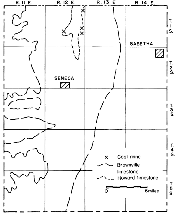
Nemaha County
Rocks of the Wabaunsee group, from the Severy shale to the Brownville limestone, crop out in the western half of Nemaha County (Fig. 27). The presence of coal in these rocks has been known since at least 1866 (Mudge, p. 18; Swallow, p. 56) and it was used for domestic fuel as early as 1875 (Cray, p. 352). In 1879 or 1880 (Hudson, 1881, p. 246) two shafts were worked to a limited extent in Illinois township (T. 4 S., R. 12 E.). Although these mines have not been located, the coal most likely was either the Nyman or the Lorton (Fig. 3). It was about this same time that the Nodaway coal cropping out in the bluffs of Nemaha River west of Bern was first reported. Sims (1883, p. 357) mentions limited coal mining in Illinois township (T. 4 S., R. 12 E.) and near Sabetha (12 miles northwest of Sabetha in the Bern vicinity) where the coal is reported to have ranged from 18 to 24 inches in thickness. According to Stewart (1892, p. 38), 2,208 tons of coal was mined from two shafts in the Bern area in 1890 and 2,280 tons was produced in 1891. The existence of these mines and their production seemingly were known to relatively few persons, even among those living near the coal mines. Gallagher (1894, p. 66), reported that he visited Bern with the intention of inspecting the mines reported by Stewart to center around that town but that he could not find them and that public officials of Bern and of the county had no knowledge concerning them. With the aid of information received from a farmer living 4.5 miles east and 1 mile north of the southeast corner of Bern and from Mr. Carl Jauken, a farmer residing 3.5 miles west of Bern, I located the mines as well as several others operated more recently.
Figure 27--Map of Nemaha County, Kansas, showing location of coal mines and traces of the Howard and Brownville limestones.
Nodaway coal
At least 12 coal mines have been operated in Nemaha County in the past (Table 30). Greatest mining activity centered in the SW sec. 24, T. 1 S., R. 12 E., at a place known locally as Tail O'Rabbits (Fig. 28). According to Jauken, coal was first mined here 70 to 75 years ago. In the early years of mining, the industry at Tail O'Rabbits had developed to the extent that a village with a hotel and school grew up around the mines. So far as I could ascertain all the mines were drift or slope mines. A similar situation and history is reported for a place called Coal City in the SW sec. 22, T. 1 S., R. 12 E., about 2.5 miles east of the Tail O'Rabbits mining district. The only evidence of coal mining activity seen at Coal City was a large coal dump and a former hotel now serving as a barn. According to Jauken, the coal was mined by shafting. Due to high water in the creek the drift mines were not seen. Other drift mines are located in the NW cor. sec. 24, in the SW cor. sec. 13, and in the SW sec. 14, T. 1 S., R. 12 E. As recently as 1940 coal was mined by stripping in the Tail O'Rabbits district in the NW sec. 24 and on the Korber place 1 mile south of the Kansas-Nebraska line in the NW NW sec. 12, T. 1 S., R. 12 E. Coal was taken from 1 to 2 acres at each strip mine.
Figure 28--Map of the Bern coal mining district, Nemaha County, Kansas, showing location of coal mines, proved coal reserve lands, and traces of the Howard and Burlingame limestones.
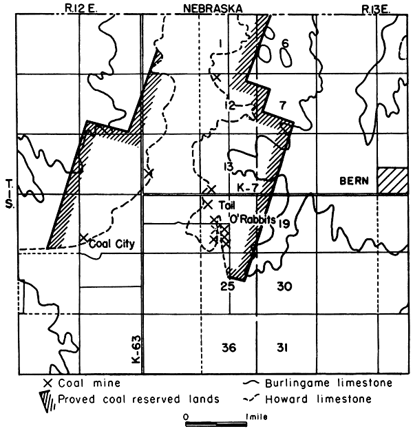
Table 30--Location and classification by type of mine of Nodaway coal mines in Nemaha County, Kansas.
| Location | Number of mines | |||||
|---|---|---|---|---|---|---|
| Shaft | Drift or slope | Strip | Total | |||
| NW | 12-1-12E | Korber place | 1 | 1 | ||
| SW cor. | 13-1-12E | 1 | 1 | |||
| SW | 14-1-12E | 1 | 1 | |||
| SW | 22-1-12E | Coal City | 1 | * | 1 | |
| NW cor. | 24-1-12E | Tail O'Rabbits | 1 | 1 | ||
| S line NW | 24-1-12E | Tail O'Rabbits | 1 | 1 | 2 | |
| SW | 24-1-12E | Tail O'Rabbits | 5 | 5 | ||
| Total | 1 | 9 | 2 | 12 | ||
| *Number not known. | ||||||
According to Stewart (1892, p. 38), the coal in the Bern area ranges from 16 to 28 inches in thickness and averages 22 inches. The only outcrop of coal seen was in the Tail O'Rabbits district along the creek bluff in the east part of the SW sec. 24, T. 1 S., R. 12 E. The coal is 10 to 12 inches thick, which I believe represents more nearly the average thickness of the coal than the 22 inches reported earlier. I am certain that if average thickness of the coal had been 22 inches, stripping operations at the two strip mines and also at several places in Nebraska south of Du Bois, Nebraska, would not have ceased after the stripping of 1 or 2 acres, especially when the overburden was thin. The coal mined in the Nemaha Valley west, north, and south of Bern is the Nodaway coal. This is probably the coal that was referred to as the Nyman coal (Moore and Landes, 1927, p. 49) and was mined in the county before rail transportation made other fuel readily available. The following stratigraphic sections show the relationship of the coal to the overlying and underlying strata.
| Measured section in the SW sec. 24, T. 1 S., R. 12 E., along the east side of a creek bluff at Tail O'Rabbits | Thickness | |||
|---|---|---|---|---|
| Feet | Inches | |||
| PENNSYLVANIAN--Virgilian | ||||
| Howard limestone--Church limestone member | ||||
| 8. Limestone, slabby, upper surface weathers into small chips | 1 | 11 | ||
| 7. Limestone, massive, well-jointed, weathers into large slabs; contains abundant fossils, crinoid stems, algal growths, brachiopods, and cephalopods. | 1 | 11 | ||
| Aarde shale member | ||||
| 6. Shale, gray | 1 | 0 | ||
| 5. Shale, black, fissile | 0 | 3 | ||
| 4. Shale, gray | 0 | 6 | ||
| 3. Coal (Nodaway) | 10-12 | |||
| Severy shale | ||||
| 2. Shale, sandy, gray | 10 | |||
| 1. Shale, clayey, dark gray, exposed to creek level | 10 | |||
| Measured section in the Kober strip mine, NW sec. 12,T. 1 S., R. 12 E. | Thickness | |||
|---|---|---|---|---|
| Feet | Inches | |||
| PENNSYLVANIAN--Virgilian | ||||
| 7. Sandstone, micaceous | ||||
| Howard limestone--Church limestone member | ||||
| 6. Limestone, slabby | 0 | 6 | ||
| 5. Limestone, massive, jointed | 1 | 6 | ||
| 4. Limestone, massive, jointed | 4 | 0 | ||
| Aarde shale member | ||||
| 3. Shale, gray | 0 | 6 | ||
| 2. Shale, black, fissile | 1 | 0 | ||
| 1. Shale, gray, exposed to pit level | 1 | |||
Production
The only recorded production of coal in Nemaha County is for 1890 and 1891 when 2,208 and 2,280 tons were mined. It is estimated that the two strip mines produced 3,000 tons of coal in 1940. As it is known that coal was mined in the county as early as 1875 and that the industry in the Tail O'Rabbits and Coal City mining districts had developed to the extent of a small village with school and hotel, it is not unreasonable to estimate the total past coal production for the county at about 30,000 tons.
Reserves
There are approximately 6 square miles, including all or parts of secs. 1, 2, 10 to 16, and 21 to 25, T. 1 S., R. 12 E., and secs. 7, 18, 19, and 30, T. 1 S., R. 13 E. (Fig. 28), in the Nemaha-Bern area underlain by Nodaway coal 12 or more inches thick. These proved coal reserve lands contain 5,760,000 tons of coal. The potential Nodaway coal reserve lands total 280 square miles and contain approximately 268,800,000 tons of 12-inch Nodaway coal.
Osage County
All of Osage County west of a line drawn through Carbondale, Scranton, Osage City, and Arvonia is underlain by rocks of the Wabaunsee group. All formations of the group are present (Pl. 1). Of all Kansas counties, Osage County is the largest producer of coals of the Wabaunsee group. The coal mined is the Nodaway coal, which crops out or is indicated by the presence of mines or dump heaps from Carbondale to Arvonia. The Elmo coal is known to occur at several places, but nowhere is it thick enough to be mined. The Upper Williamsburg coal (Bowsher and Jewett, 1943, pp. 62-64) in the Lawrence shale of the Douglas group was formerly mined in the Quenemo mining district in T. 17 S., R. 17 E., near the Osage-Franklin County line.
Nodaway coal
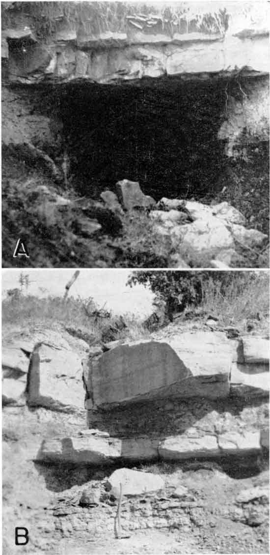
The Nodaway coal in Osage County ranges in thickness from 11 to 18 inches at the outcrop and from 12 to 36 inches underground in the shaft mines at Burlingame and Osage City. The average reported thickness of the deep mine coal is 18 inches. The coal at the outcrop is thickest between Peterton, 2 miles north of Osage City, and points 3 miles south of Osage City. The coal in this part of the county is 13 to 18 inches thick. It occurs as a single massive bed and is bright, shiny, black, brittle, and free from clay seams or impurities. On mining it breaks into large rectangular blocks, which commonly split in the middle into two distinct units. On close examination, the coal seems to be made up of thin layers 1/16 to 1/2-inch thick, giving the coal a laminated appearance. Highly carbonized coaly material showing the impression and structure of the woody material from which the coal was derived is commonly present in the uppermost hall, inch of the coal. The coal occurs 4.5 to 9 feet below the Church limestone and 1 to 6 feet above the Bachelor Creek limestone, which in Osage County and southward constitutes the base of the Howard limestone formation (Fig. 4). Nodaway coal crops out at the surface in Osage County along the edge of the Howard limestone escarpment where it has been extensively mined by stripping. Westward from the escarpment the coal is gradually buried deeper. The deepest coal mined at the present time, 120 feet beneath the surface, is in the Bell No. 4 mine about 1 mile south of Burlingame in the SW cor. NW sec. 23, T. 15 S., R. 14 E. (Pl. 3C). Since there are active mines, good coal samples could be collected. The samples were analyzed by August Fleming in the laboratories of the State Geological Survey and are presented in Tables 3 and 4. A comparison of proximate analyses of Osage County coals with those of other Kansas coals (Table 5) shows that the Nodaway coal compares favorably with other coals mined commercially in Kansas.
Mines and raining methods
In the fall of 1945, there were 10 mines (Table 31) in operation in Osage County as compared with 90 mines in 1891. The 302 Nodaway coal mines in the county that were active at one time or another have been located and plotted on a map (Pl. 1). Most of these mines are now represented only by dump heaps, a few by abandoned shafts and buildings, some by strip pit scars and caved-in drift mine openings, 6 by active operating shafts, and 4 by active strip pits. The mines follow closely the edge of the Howard limestone escarpment, the tracks of the Santa Fe Railroad, and both sides of highway US 50 N. The greatest concentration of mines is between Scranton and Burlingame, at Osage City and surrounding territory, and at Arvonia.
Table 31--Location and mining data on Nodaway coal mines active in Osage County, Kansas, in 1944 and 1945. [Since this report went to press (November 1946) two new strip mines are being opened. One of these mines is on the farm of C. Muykendall in the SW cor. sec. 18, T. 17 S., R. 15 E., about 4 miles east of Barclay. The other, operated by Ellis Graham, is at the west edge of Arvonia in the SW SW sec. 16, T. 18 S., R. 14 E.]
| Location | Name of mine | Operator | Type of mine | Depth of mine, feet | Thickness of coal, inches |
Distance mined from shaft, feet | No. men employed | Prox. analysis no. |
|---|---|---|---|---|---|---|---|---|
| NW 13-15-14E | Eliott | Clarence Eliott | Shaft | 109 | 18 | 900 | 22-25 | 11 |
| NE cor. 14-15-14E | J. C. | James Curley | Shaft | 113 | 17-18 | 500 | 10 | |
| NW 23-15-14E | Bell No. 4 | William Isaacs | Shaft | 120 | 16-20 | 35 | 3-4 | 9 |
| NE cor. SE 22-15-14E | Central Fuel No. 2 | Neal Hotchkiss | Shaft | 116 | 18 | 600 | 7 | |
| SW 23-15-14E | Central Fuel No. 3 |
Neal Hotchkiss | Shaft | 116 | 18 | 600 | 12-15 | 8 |
| NW cor. NE 22-16-14E | Didier & Parre No. 1 | James Parre | Shaft | 116 | 13-18 | 700 | 6 | |
| NW 17-16-15E | Ira Rogers | Strip | 8-9 | 16-18 | 5-6 | 4.5 | ||
| SE 17-18-14E | Ellis Graham | Strip | 10 | 13 | 4 | |||
| SW 20-18-14E | H. A. Rogers & Sons | Strip | 8 | 13-16 | 4 | 1.2 | ||
| NE 19-14-16E | Perry Jones and R. A. Linville | Strip | 9-20 | 20 | 2 |
Strip mines
In the fall of 1944 three strip mines were in operation. A fourth strip mine in the NE. sec. 19, T. 14 S., R. 16 E. was being prepared for mining by Perry Jones and R. A. Linville of Carbondale at the time of my visit on August 7, 1945 (Table 35). This mine was operated from 1939 to 1942. The coal averages 20 inches in thickness, underlies 4 to 5 acres, and has an overburden ranging from 9 to 20 feet. At the time of my visit scattered debris was being removed by means of a large Diesel caterpillar. The mine is approximately 1 mile west of highway US 75 at Carbondale. The Ira Rogers strip mine is in the NW sec. 17, T. 16 S., R. 15 E., about 2.5 miles east and 1.5 miles north of the Santa Fe Railroad depot in Osage City. The coal is 16 to 18 inches thick and is overlain by 2 feet of bluish-gray shale, which in turn is overlain by a 6- to 8-inch dense limestone. Above the limestone is 1 foot of black fissile shale and 2 feet of gray shale on which 3 feet of Church limestone rests. The overburden, often the massive Church limestone, is removed by a bulldozer after being shot. The coal is then wedged or pried loose along the face of the coal and loaded by hand into waiting trucks (Pl. 2C) which haul the coal to near-by and distant towns (Fig. 5). At the H. A. Rogers strip mine southwest of Arvonia, in the SW sec. 20, T. 18 S., R. 14 E., the coal crops out in the bed of a stream. It is 13 to 16 inches thick. The overburden, which is composed of shale and the Church limestone, is 8 feet thick. Mining conditions are practically the same as at the Ira Rogers strip mine northeast of Osage City. According to H. A. Rogers, who with his sons operates the mine, the coal is trucked as far west as the Kansas-Colorado line including such towns as Burlington, Burns, Council Grove, El Dorado, Elmdale, Emporia, Eureka, Gridley, Hartford, Hutchinson, Iola, Junction City, Kingman, Lamont, Lebo, LeRoy, Madison, Marion, Neosho Rapids, Olpe, Osage City, Peabody, Pratt, Quenemo, Reading, Strong City, Waverly, Westphalia, Wichita, and Yates Center (Fig. 5). The third strip mine is operated by Ellis Graham and is located west of Arvonia in the SE sec. 17, T. 18 S., R. 14 E. The coal is 13 inches thick and lies 10 feet beneath the surface.
Plate 4--A, Only active drift mine in the Osage coal field, started in the fall of 1943 by Gaston Rolins in the NE sec. 10, T. 9 S., R. 18 E., Jefferson County, Church limestone, 23 inches thick, forms roof of mine. Nodaway coal, 14 inches thick, exposed on the right hand wall just below middle of mine opening. B, Outcrop of lower half of the Howard limestone formation. Massive uppermost bed is typical Church limestone. The Nodaway coal, here represented by only a streak is immediately beneath the thin dense limestone which is persistent from Osage County southward. The adz marks the position of the Bachelor Creek or basal limestone member of the formation. Cut along U.S. 166 in the SE cor. SW sec. 3, T. 34 S., R. 9 E., Chautauqua County.
All the strip mines are along the edge of the Howard limestone escarpment, the greatest concentration being in the Carbondale and Arvonia mining districts. The largest single stripped mine area is east and south of Carbondale in secs. 17, 19, 20, 29, and 30, T. 14 S., R. 16 E. (Pl. 1). With the exception of the pit recently re-opened by Jones and Linville in sec. 19, the mines are abandoned, although unmined areas exist between the various strip pits. Coal formerly was also mined by the stripping method east and south of Scranton in secs. 2, 11, and 14, T. 15 S., R. 15 E. In secs. 12 and 13, T. 17 S., R. 14 E., and secs. 17, 19, and 20, T. 17 S., R. 15 E., 3 to 6 miles east of Barclay, coal has been mined by stripping at about 12 localities. South and east of Barclay, in the NE sec. 34, T. 17 S., R. 14 E., is a strip pit covering several acres, and in the NW and SW sec. 4, T. 18 S., R. 14 E., are two other strip mines. There are at least 20 strip pits at Arvonia and in secs. 7, 17, 18, 20, 21, 22, 28, 29, 31, and 32, T. 18 S., R. 14 E. (Pl. 1). The H. A. Rogers strip mine is in the Arvonia mining district.
Deep mines
Of the 302 Wabaunsee coal mines in Osage County, 174 are shaft mines. In the early years of mining, however, slope or drift mines along the edge of the Howard limestone escarpment were common.
A glance at the coal mining map of Osage County (Pl. 1) shows that the shaft mines follow closely the tracks of the Santa Fe Railroad or dot both sides of highway US 50 N. Very few shaft mines are found any distance away from these two main transportation arteries. The greatest concentration of deep mines is between Scranton and Burlingame and in the Osage City area. A large number of mines were formerly located within the city limits of Scranton and Osage City (Fig. 29) so that today these cities are more or less honeycombed with underground passageways, one of which is illustrated in Figure 30.
Figure 29--Maps showing location and distribution of coal mines in and near Scranton and Osage City, Osage County, Kansas.
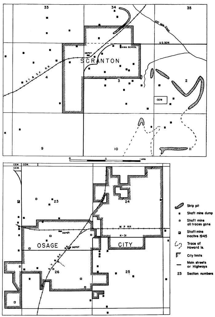
Figure 30--Plat showing tunnels of Western Coal No. 1 mine just north of the Cen. sec. 26 on October 30,1890, under part of Osage City, Osage County, Kansas. (See Fig. 29).
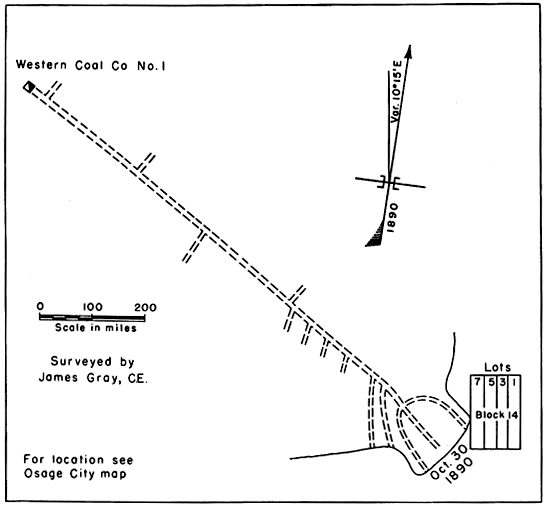
Plate 5--A, Typical shaft mine in the Osage coal field. The mine, Didier and Parre No. 1 about 1 mile northwest of Osage City in the NE sec. 22, T. 16 S., R. 14 E., is now abandoned. B, Outcrop of 14-inch Nodaway coal bed beneath the Church limestone, 1 1/2 miles north of Lancaster in the NW sec. 21, T. 5 S., h. 19 E., Atchison County. Photographs by R. E. Whitla.
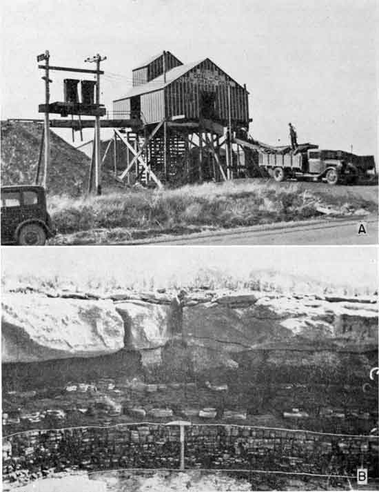
Only six shaft mines produced coal during the mining season of 1944 and 1945 (Table 31). These mines reach depths of 109 to 120 feet. The coal in all of them is cut by machine, hoisted electrically, and mined by the longwall system. The coal is undercut by machines which cut a swath 27 to 28 inches wide and 6 inches thick in the underclay beneath the coal. After the coal has been undercut for several hours, the weight of the overburden causes the coal to break down without wedging or shooting. The coal is then placed by hand on small cars and pushed to the shaft opening. From there it is hoisted electrically to the top of the tipple room, where it is weighed and finally chuted down to receiving trucks, the only means by which the coal is hauled away. No present coal mine has railroad connections. Shaft mine openings range from 4.5 by 9 to 6 by 13 feet. The depth of the shaft mines varies with the distance of the mines westward in the direction of dip of the strata from the face or outcrop of the coal along the escarpment border. Miscellaneous mining data pertaining to these mines are presented in Table 29.
Only one of the active mines, the Didier and Parre No. 2 in the NW cor. NE sec. 22, T. 16 S., R. 14 E., produced coal in the Osage City mining district. It is 116 feet deep. The coal ranges in thickness from 13 to 18 inches and has been mined 700 feet distant from the shaft opening. The remaining five active shaft mines are in the Burlingame mining district, south and east of Burlingame in secs. 13, 14, 22, and 23, T. 15 S., R. 14 E (Pl. 3A). One of these mines, the Bell No- 4 in the NW sec. 23 was opened in March 1944 (Pl. 3C). At the time of my visit on August 17, 1944, the coal, which is 18 inches thick, was being mined at a distance of 35 feet from the shaft opening. The mine is 120 feet deep and is the deepest one in the district.
History of mining
According to Ben Lowes (personal communication), a former miner now farming southeast of Scranton, coal was first discovered in Osage County in the early 1850's in the creek bed of 110 Creek a short distance north of the Santa Fe bridge southwest of Scranton. Coal was mined before 1867 when Ira Philbrick opened a strip mine, a little more than 1 mile east of Scranton in sec. 2, T. 15 S., R. 15 E. In the spring of 1869 (Crane, 1898, pp. 189-190) John F. Dodds, living at Carbon Hill east of Carbondale in Osage County, accidentally encountered the Nodaway coal while digging a well on top of a hill. This find, according to some, resulted in the opening of the Osage City coal-mining district, although, as just mentioned, coal was mined east of Scranton by stripping before 1867. Mines were opened at Osage City by Godfrey and Price of Hannibal, Missouri, in the fall of 1869. Interest in the mines operated under the name of the Carbon Coal and Mining Company of Missouri was bought a year or two later by T. J. Peter, who substituted the word Kansas for Missouri in the name (Young, 1925, p. 48). It seems, however, that early mining operations were not very successful (Brown, 1896, p. 17) and that up to 1871 the industry was practically a failure, both in regard to the quantity of coal mined and the cost of production. According to Brown (1896, p. 17), the poor showing of the mines was due primarily to the application of wrong mining methods for coals having thicknesses of only 12 to 16 inches. In 1871 under the direction of Robert Craig, a highly capable mining engineer, the longwall plan of mining was inaugurated and horsepower plants to hoist the coal out of the shafts were erected. Under Craig's management the coal mines became profitable, new shafts were sunk, and many practical miners from eastern states were brought to work in the mines. The coal-mining industry in Osage County flourished, and for a number of years it became the leading county in Kansas in the production of coal and in the number of men employed in mining west of the Mississippi River.
At Scranton and vicinity mining started before the opening of the Ira Philbrick strip mine in 1867 in sec. 2, T. 15 S., R. 15 E. (Lowes, personal communication). In 1871 O. H. Sheldon and Elix Thomas, co-founders of Scranton, opened a slope mine east of Scranton, and in 1872 they sank the first shaft mine at Scranton in the NE cor. NW SE sec. 3. In 1873 several shafts were sunk, including the Osage Carbon Company No. 1 mine in the north part of Scranton in the SE cor. SW SW sec. 34. This mine is reported to have been the first one in the district served by a railroad spur. According to Crane (1898, p. 190), coal mining at Scranton did not start until 1874. In 1874 the first shaft mine was sunk at Peterton, a small community 2 miles north of Osage City. Although coal was mined along the coal outcrop near Burlingame as early as 1866 (Swallow, 1866, p. 120), seemingly no shaft mining was done in this part of Osage County until 1878 or 1879.
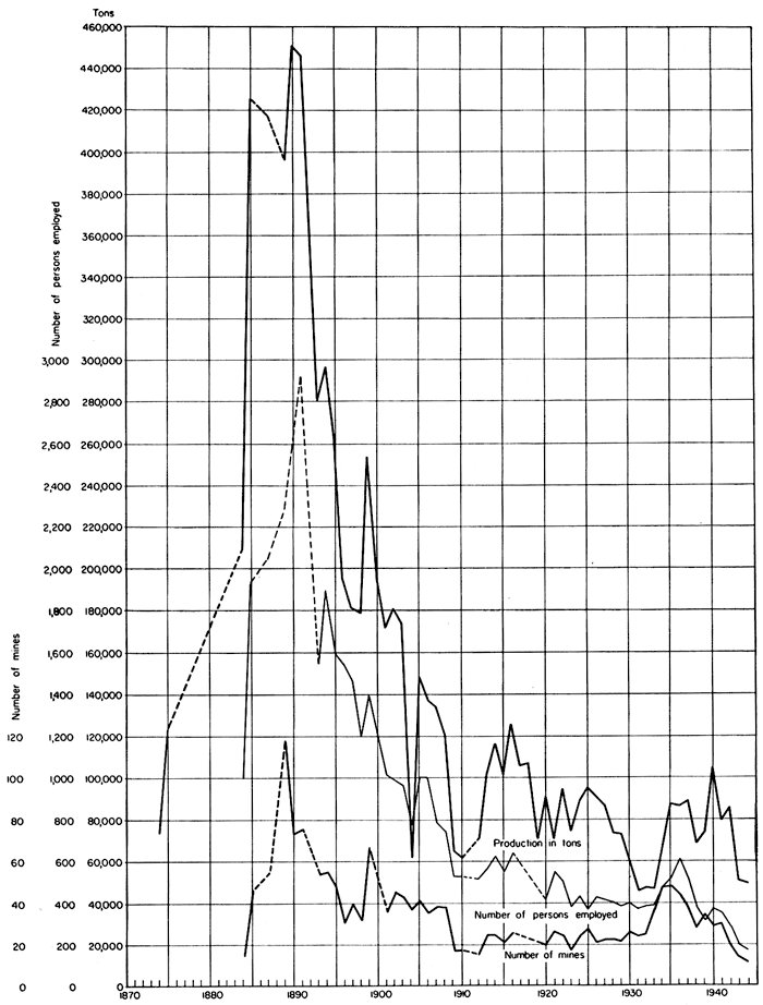
Up to 1880 the T. J. Peter Company was the principal coal-mining company in the Osage County district. In that year the Atchison, Santa Fe, and Pacific Railroad bought a half interest in the Peter company and a year or two later became the sole owner and operator of the company. Because of the importance of coal to the railroad, the Santa Fe system soon acquired mining rights to about 30,000 acres of land and became the principal coal-mining operator in Osage County. The Santa Fe mines in Osage County practically supplied the whole Santa Fe system with coal for all points east of Colorado from 1880 until its mines were opened in Crawford County. The coal of the Santa Fe mines furnished power for the trains of the Santa Fe system, and much of the coal was shipped into the general market. By 1898 the Santa Fe Railroad had reduced its Osage County land holdings by one-half, and in that year it leased its entire coal-mining property in Kansas to the Mount Carmel Coal Mining Company. In 1898, 31 mining companies were operating in the Osage district; however, the Mount Carmel Company did more than 45 percent of the coal business. The Osage County coal-mining district, at one time the most important district in Kansas, has steadily declined in coal production since 1893. In 1889, 118 mines were in operation, employing about 2,000 men. Maximum production was reached in 1890 when the 73 mines in operation produced 452,751 tons of coal. In 1944, less than 200 men working in 8 mines (6 shaft and 2 strip mines) were producing Nodaway coal in Osage County. Figure 31 and Table 33 show for the various years the annual coal production, number of mines in operation, and the number of persons employed.
Present production
The trend of coal mining in Osage County in the last decade is presented in Table 32. The general decrease in number of mines and production since 1940 is due largely to the shortage of manpower caused by the war. In 1940, 30 operating coal mines employed 377 men who produced 103,885 tons of coal. By 1943 the number of mines had decreased to 13, the number of men employed had dropped to 195, and production of coal had dropped to 51,239 tons. In the first half of 1944, 10 shaft and 4 strip mines employed 173 men who produced 20,342 tons of coal. During the second half of 1944 the number of mines decreased to 6 shaft and 3 strip but production amounted to 28,519 tons.
Table 32--Trend of coal mining and production in Osage County, Kansas, 1935-44.
| Year | Shaft mines | Strip mines | Totals | ||||||
|---|---|---|---|---|---|---|---|---|---|
| No. of mines |
Men employed |
Tons | No. of mines |
Men employed |
Tons | No. of mines |
Men employed |
Tons | |
| 1935 | 75,734 | 13,393 | 48 | 521 | 89,127 | ||||
| 1936 | 37 | 77,065 | 12 | 11,530 | 612 | 88,595 | |||
| 1937 | 28 | 82,184 | 10 | 8,268 | 38 | 90,452 | |||
| 1938 | 22 | 62,368 | 6 | 5,670 | 28 | 68,038 | |||
| 1939 | 24 | 65,276 | 8 | 8,055 | 32 | 73,331 | |||
| 1940 | 22 | 95,515 | 8 | 8,370 | 30 | 377 | 103,885 | ||
| 1941 | 23 | 74,813 | 7 | 4,348 | 30 | 79,161 | |||
| 1942 | 16 | 81,797 | 6 | 3,383 | 22 | 85,180 | |||
| 1943 | 9 | 177 | 45,687 | 4 | 18 | 5,552 | 13 | 195 | 51,239 |
| 1944* | 10 | 16,716 | 4 | 3,626 | 14 | 173 | 20,342 | ||
| 1944§ | 6 | 24,492 | 3 | 4,027 | 9 | 28,519 | |||
| *First half. §Second half. |
|||||||||
Cumulative production
The cumulative coal production of Osage County from 1869 to 1944 is 11,448,861 tons. The peak of production was reached in 1890 when 452,751 tons of coal were produced. The period from 1885 to 1892 marks the greatest development of the Osage County mining industry. Seventy-five mines employing 2,917 men were operated in 1891. The annual production from 1874 to 1944 is tabulated in Table 33 and shown graphically in Figure 31.
Table 33--Annual coal production, number of mines, and number employed in the Nodaway coal mines of Osage County, Kansas, 1874 to 1944 (See Figure 31).
| Year | Tons | Number of mines |
Number of persons employed |
|---|---|---|---|
| 1874 | 73,400 | ||
| 1875 | 123,400 | ||
| 1884 | 208,735 | 15 | 1,000 |
| 1885 | 425,834 | 45 | 1,936 |
| 1886 | |||
| 1887 | 417,607 | 54 | 2,044 |
| 1888 | |||
| 1889 | 396,784 | 118 | 2,271 |
| 1890 | 452,751 | 73 | |
| 1891 | 447,920 | 75 | 2,917 |
| 1892 | 372,306 | ||
| 1893 | 280,213 | 54 | 1,558 |
| 1894 | 296,011 | 55 | 1,887 |
| 1895 | 263,036 | 48 | 1,604 |
| 1896 | 195,652 | 30 | 1,544 |
| 1897 | 181,857 | 40 | 1,463 |
| 1898 | 179,070 | 32 | 1,201 |
| 1899 | 253,668 | 66 | 1,396 |
| 1900 | 193,529 | 53 | 1,369 |
| 1901 | 171,753 | 36 | 1,015 |
| 1902 | 180,211 | 45 | 994 |
| 1903 | 173,451 | 43 | 961 |
| 1904 | 60,786 | 37 | 788 |
| 1905 | 148,106 | 41 | 1,000 |
| 1906 | 136,443 | 35 | 998 |
| 1907 | 133,990 | 38 | 788 |
| 1908 | 120,496 | 38 | 745 |
| 1909 | 64,929 | 17 | 530 |
| 1910 | 60,847 | 17 | 531 |
| 1911 | |||
| 1912 | 71,421 | 15 | 520 |
| 1913 | 101,151 | 24 | 588 |
| 1914 | 115,554 | 24 | 623 |
| 1915 | 102,006 | 21 | 553 |
| 1916 | 124,926 | 25 | 640 |
| 1917 | |||
| 1918 | |||
| 1919 | |||
| 1920 | 90,879 | 20 | 416 |
| 1921 | 70,612 | 26 | 545 |
| 1922 | 92,787 | 24 | 504 |
| 1923 | 74,047 | 17 | 386 |
| 1924 | 88,614 | 25 | 430 |
| 1925 | 95,227 | 27 | 374 |
| 1926 | 91,671 | 21 | 458 |
| 1927 | 86,768 | 22 | 415 |
| 1928 | 73,408 | 22 | 406 |
| 1929 | 72,801 | 21 | 380 |
| 1930 | 62,040 | 26 | 398 |
| 1931 | 45,984 | 24 | 376 |
| 1932 | 46,885 | 25 | 383 |
| 1933 | 46,932 | 37 | 387 |
| 1934 | 67,879 | 47 | 478 |
| 1935 | 89,127 | 48 | 521 |
| 1936 | 88,595 | 44 | 612 |
| 1937 | 90,452 | 38 | 521 |
| 1938 | 68,038 | 28 | 385 |
| 1939 | 73,331 | 32 | 317 |
| 1940 | 103,885 | 30 | 376 |
| 1941 | 79,161 | 30 | 354 |
| 1942 | 85,180 | 22 | 285 |
| 1943 | 51,239 | 13 | 195 |
| 1944 | 48,861 | 11 | 173 |
Figure 31--Graph showing annual production of Nodaway coal, number of persons employed, and number of mines in operation in Osage County, Kansas, from 1874 to 1944.
A study of the spacing of the strip mines and the distribution of shaft mines near the border of the Howard limestone escarpment indicates that all land in a strip 0.5 mile wide from the south county line to the north edge of Scranton and skirting the Howard limestone escarpment should be considered proved coal reserve land suitable for stripping. This area totals approximately 30 square miles, to which 2 square miles should be added for proved coal reserve lands in the Carbondale mining district. Presuming that the coal averages 14 inches in thickness, the 32 square miles proved coal reserve lands suitable for stripping contain 35,840,000 tons of coal less the amount of coal thus far removed. The proved reserve area also includes 37 square miles in which the coal lies too deep to be stripped but is suitable for shaft mining. This area is underlain by coal averaging 18 inches in thickness and contains 53,280,000 tons of coal less the amount already produced. The total proved coal reserve area consists of 69 square miles containing approximately 77,670,000 tons of proved coal reserve. Proved and potential coal reserve areas and tonnage by mining districts are presented in Table 34.
Table 34--Proved and potential Nodaway coal reserve lands and tonnage by mining districts in Osage County, Kansas.
| Mining District | Location | Proved reserves | Potential reserves | |||||||
|---|---|---|---|---|---|---|---|---|---|---|
| Thickness of coal, inches |
Strip mines, sq. miles |
Deep mines, sq. mile |
Strip mines, tons |
Deep mines, tons |
Total, tons |
Thickness of coal, inches |
Sq. miles |
Tons | ||
| Carbondale | Secs. 24, 25, 36-14-15E 19,29,30-14-16E |
14 | 2 | 2,240,000 | 2,240,000 | 12 | 60 | 57,600,000 | ||
| Scranton-Burlingame | Secs. 1, 2, 10 to 16, 21 to 28-14-16E | |||||||||
| Secs. 26 to 29, 31 to 34-14-15E | 14 | 6 | 6,720,000 | |||||||
| Secs. 1 to 11, 14 to 20, 29, 30-15-15E | 18 | 19 | 27,360,000 | 34,080,000 | 18 | 122 | 175,680,000 | |||
| Osage City | Secs. 27, 28, 33 to 36-15-14E 31-15-15E |
|||||||||
| 1, 2, 3, 10 to 15, 21 to 28,32 to 35-16-14E |
14 | 9 | 10,080,000 | |||||||
| 6, 7, 17 to 19, 30-16-15E 1,2,3-17-14E |
18 | 18 | 25,920,000 | 36,000,000 | ||||||
| Barclay | Secs. 10 to 16, 21 to 28, 33 to 35-17-14E 7, 18 to 20-17-15E 3 to 6, 9,10-18-14E |
14 | 9 | 10,080,000 | 10,080,000 | |||||
| Arvonia | Secs. 13,24-18-13E 16 to 22, 28 to 32-18-14E |
14 | 6 | 6,720,000 | 6,720,000 | 12 | 50 | 48,000,000 | ||
| Total | 32 | 37 | 35,840,000 | 53,280,000 | 89,120,000 | 232 | 281,280,000 | |||
| Cumulative production | 11,448,861 | 11,448,861 | ||||||||
| Approximate reserves | 77,670,000 | 269,830,000 | ||||||||
Potential reserves
Practically all lands in Osage County underlain by Wabaunsee rocks contain potential coal reserves. The Scranton-Burlingame potential coal reserve consists of 122 square miles underlain by 18-inch coal and contains 175,680,000 tons of coal. The Arvonia and Carbondale areas embrace 50 and 60 square miles, respectively. On the basis of a 12-inch coal, these areas contain 105,600,000 tons. The total potential reserve tonnage, therefore, is 281,280,000 less 11,448,861 tons of coal already mined, or approximately 269,830,000 tons (Table 34).
Pottawatomie County
Rocks of the Wabaunsee group from the Burlingame to the Brownville limestone formations crop out to a limited extent in Pottawatomie County. The Wabaunsee rocks are found primarily in a triangular area bounded by Duluth on the west, Havensville on the east, Onaga toward the south, and by the valley of Vermillion River and its tributaries on the west toward Louisville. From Louisville the rocks are exposed westward on both sides of Pleasant Run Creek. The strata also crop out in Kansas River Valley near Wamego and in Big Blue River Valley east of Manhattan (Fig. 32).
Figure 32--Map of Pottawatomie County, Kansas, showing location of coal mines and outcrops of the Wabaunsee group of rocks.
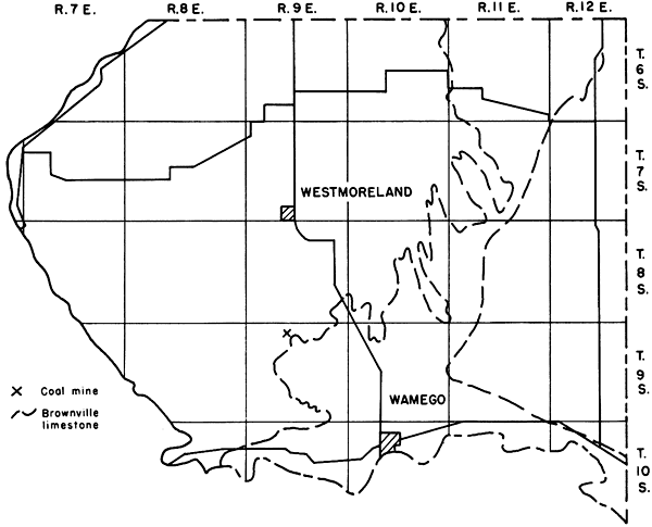
Lorton coal
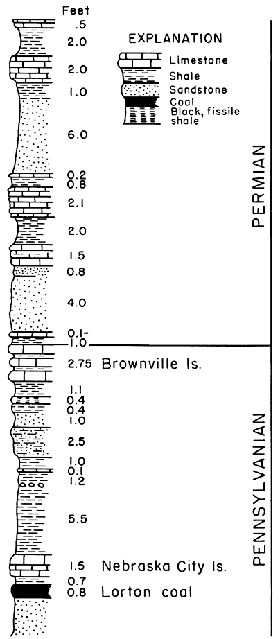
The Elmo coal is known to occur at several places in the above-defined area, but is too thin to be minable. The only coal reported mined in Pottawatomie County, Lorton coal in the French Creek shale formation, is found a short distance northwest of the Cen. SE sec. 4, T. 9 S., R. 9 E., along Rock Creek about 1.5 miles due east of Flush. The coal is 10 inches thick and occurs 3 feet above water level of Rock Creek at the base of a steep bluff 50 or more feet high (Fig. 33). It is hard, bright, and shiny, and is reported to burn well. The coal underlies the Nebraska City limestone member of the Caneyville limestone formation, from which it is separated by 8 inches of black jack or coaly silty clay. The Nebraska City limestone is a dark-gray, well-jointed, highly fossiliferous impure limestone 1.5 feet thick. The upper foot is massive whereas the lower part weathers into small chips. Light-bluish siltstone or fine-grained sandstone underlies the coal. The Nebraska City limestone at this locality is 13 feet below the base of the Brownville limestone, the top of the Pennsylvanian rocks in Kansas. The coal was taken along the outcrop, but because of difficulty in getting to it very little has been mined. The coal is too close to creel,. level for drifting and too much rock overlies it for stripping. Much coal can be taken from the face of the outcrop, however.
Figure 33--Stratigraphic section of strata exposed in Rock Creek in the SE sec. 4, T. 9 S., R. 9 E., Pottawatomie County, Kansas, showing position of Lorton coal and adjacent rocks.
Production and reserves
Coal has been mined in Pottawatomie County solely for local use and there are no production figures available. It is doubtful whether more than 100 tons of coal have been mined. Because of the nearness of the coal to present normal water level and because of the excessive overburden the coal is deemed commercially unminable and thus constitutes no proved coal reserve. Potentially, 200 square miles are underlain by the 10-inch coal seam, thus affording a potential coal reserve of 160,000,000 tons of Lorton coal.
Shawnee County
With the exception of all territory south of Kansas River and east of a north-south line extending south from the east limits of Topeka, all of Shawnee County is underlain by strata belonging to the Wabaunsee group (Fig. 34). All formations of the group from the Severy shale to and including the Brownville limestone are present in the county. Three coals, the Nodaway, Elmo, and an unnamed coal in the Wamego shale, have been mined from 38 known mines (Table 35) in the county.
Figure 34--Map of Shawnee County, Kansas, showing location of coal mines and outcrops, proved coal reserve lands, and traces of the Howard, Burlingame, Reading, Tarkio, Dover, and Brownville limestones.
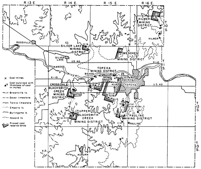
Nodaway coal
The Nodaway coal crops out at a number of places from north to south across the county close to the subdued escarpment of the Howard limestone. The coal ranges from 2 to 17 inches in thickness. It is 2 to 3 inches thick along the half section line road in secs. 23 and 26, T. 10 S., R. 16 E., just north of Kilmer. On both sides of State highway K 4 along Muddy Creek in the NE and SE sec. 10, T. 10 S., R. 16 E., about 2 miles west of Meriden in Jefferson County, the coal is 10 to 12 inches thick. Several drift mines are located at this locality. The coal is 13 inches thick 2.25 miles east and 1.75 miles north of Menoken in the NE cor. sec. 11 and the NW cor. sec. 12, T. 11 S., R. 15 E. Here also the coal was formerly mined by stripping and by drifting. At the abandoned quarry and brick plant at the west edge of Topeka north of Gage Park the coal is 12 inches thick, and 0.25 mile farther north and a short distance west along the Kansas River bluffs skirting the tracks of the Rock Island and Pacific Railroad the coal ranges from 12 to 17 inches in thickness. Coal 12 to 17 inches thick was also observed in a north-facing bluff of Shunganunga Creek in the SE sec. 10, T. 12 S., R. 15 E., about 1 mile south and a little west of the southwest corner of Topeka. At the old Capital strip pits in the SW sec. 13, T. 12 S., R. 15 E., and in the NE sec. 26 and the NW sec. 36, T. 12 S., R. 15 E., the Nodaway coal is 11 to 12 inches thick. In the SE cor. sec. 11, T. 13 S., R. 15 E., a 15-inch black shaly coal containing a clay parting 1 inch thick crops out 25 inches below the Church limestone. A little less than 1 mile south and 1.5 miles west, in the SW sec. 15, the coal is 10 inches thick. The coal is only 3 inches thick at the escarpment edge in the SW cor. SE sec. 20, T. 12 S., R. 16 E., 1.5 miles north and 1.5 miles east of Pauline.
The Bachelor Creek limestone is missing in Shawnee County; hence the coal is overlain and underlain by shale. The overlying shale is partly grayish and partly black, has a tendency to be papery to fissile, and ranges in thickness from 1 foot 8 inches to 6 feet 10 inches. The overlying Church limestone consists of a single massive hard dense rock normally 1 foot 3 inches to 2 feet 9 inches thick. In the SW sec. 15, T. 13 S., R. 15 E., the Church limestone either is abnormally thick, measuring 4 to 5 feet, or is overlain directly by the Utopia limestone. Above the Church limestone is the Winzeler shale which commonly is dark gray and ranges from 2 feet to 6 feet 8 inches in thickness. Above the Winzeler shale is the Utopia limestone which consists of several limestone beds interspersed with shale, some of which is black, fissile, and contains abundant white ostracodes. The uppermost limestone bed of the Utopia is filled with numerous robust fusulinids. The entire Utopia limestone member is present and well exposed at the following localities: (1) Kansas River bluffs along the tracks of the Rock Island and Pacific Railroad north of Gage Park, Topeka, in sec. 27, T. 11 S., R. 15 E., and (2) in a road cut and stream bluff north of Topeka in secs. 11 and 12, T. 11 S., R. 15 E. At these two localities the Utopia limestone is respectively 5 feet 8 inches and 4 feet 9 inches thick. Stratigraphic sections showing the Nodaway coal and associated rocks are presented in Figure 4.
Of the 38 known coal mines in Shawnee County 25 derived their coal from the Nodaway seam. Of these 3 were strip, 5 were shaft, and 17 were drift mines (Table 35). The Nodaway coal was formerly mined in what is now the west part of Topeka in the Gage Park neighborhood; in the northeast corner of the county along Muddy Creek in the E2 sec. 10, T. 10 S., R. 16 E; northeast of Menoken at the junction of secs. 2 and 12, T. 11 S., R. 15 E.; along Shunganunga Creek in sec. 10, T. 12 S., R. 15 E; in the SW sec. 13, T. 12 S., R. 15 E. on the east side of the Topeka-Burlingame road about 1.5 miles south of the city limits of Topeka; and in the NE sec. 26, T. 12 S., R. 15 E.
Table 35--Location and classification by type of mine of coal mines in Shawnee County, Kansas.
| Location | Name of mine |
Coal bed | Average thickness of coal, inches |
Number of mines | |||
|---|---|---|---|---|---|---|---|
| Shaft | Drift | Strip | Total | ||||
| E2 10-10-16E | Nodaway | 10-12 | 4 | 4 | |||
| NW cor. NE 1-11-14E |
Elmo | 12-16 | 2 | 3 | 5 | ||
| SE cor. 2-11-15E | Nodaway | 13 | 1 | 1 | |||
| NW cor. 12-11-15E | Nodaway | 13 | 3 | 3 | |||
| 36-11-14E | Elmo | 12 | 1 | 1 | |||
| NW 26-11-15E | Nodaway | 12-17 | 4 | 4 | |||
| SW 26-11-15E | Bailey | Nodaway | 1 | 1 | |||
| 27-11-15E | McRoberts | Nodaway | 1 | 1 | |||
| SW 29-11-15E | Sugar works or Bishop |
Elmo | 16 | 1 | 1 | ||
| SE 31-11-15E | Eddy | Elmo | 16 | 1 | 1 | 2 | |
| SE 32-11-15E | Nodaway | 1 | 1 | ||||
| 34-11-15E | Heaton | Nodaway | 1 | 1 | |||
| Cen. 34-11-15E | Walwork | Nodaway | 1 | 1 | |||
| NW cor. NE 35-11-15E |
Eaton | Nodaway | 1 | 1 | |||
| NW 10-12-14E | Crossdale | Elmo | 14-18 | 1 | 1 | ||
| NE 10-12-14E | Crossdale | Elmo | 14-18 | 2 | 2 | ||
| NE 27-12-14E | Unnamed | 14-18 | 1 | 1 | |||
| SW 10-12-15E | Nodaway | 1 | 1 | ||||
| SE 10-12-15E | Nodaway | 12-17 | 2 | 2 | |||
| SW 13-12-15E | Capital | Nodaway | 11-12 | 1 | 1 | 2 | |
| NE 26-12-15E | Coffman | Nodaway | 13 | 2 | 2 | ||
| Summary | Nodaway | 5 | 17 | 3 | 25 | ||
| Elmo | 3 | 8 | 1 | 12 | |||
| Unnamed | 1 | 1 | |||||
| Total | 8 | 25 | 5 | 38 | |||
The presence of the coal at Topeka was known to the early pioneers who settled and founded the city in the middle of the 19th century. Both Mudge (1866, p. 19) and Swallow (1866, p 56) mention the coal at Topeka, and Mudge (1866, p. 19) reports that coal was obtained in numerous places by stripping 1 to 3 feet of overlying soil from coal 12 to 16 inches thick. The coal at Topeka is reported by Gray (1875, p. 408) to be 14 to 20 inches thick and to occur 15 to 20 feet below the surface. He also states that the coal was used to quite a large extent for local, domestic, and manufacturing purposes. St. John (1883, p. 585) correctly correlated the coal mined at Topeka with that mined in Osage County. For some unexplained reason, however, St. John's correlation was overlooked, for as late as 1896 Haworth (1896b, p. 304; Bennett, 1896, p. 209) asserted that the coal at Topeka "is not the geologic equivalent of any other coal known in the state, unless possibly the coal claimed to have been discovered recently in Jefferson County should be correlated with it." Haworth and others believed that the coal mined near Dover and Silver Lake in the western part of the county was the equivalent of the Osage County coal. In 1896 Beede, in studying the stratigraphy of Shawnee County (Haworth, 1896a, p. 161 fn.; Beede, 1898, p. 29), confirmed St. John's correlation and also established the fact that the coal discovered at Valley Falls in Jefferson County was the same as that mined at Topeka. Most of the coal at Topeka and vicinity was mined by drifting into the hillsides. Extensive stripping, however, was done at the Capital mines located east of the Topeka-Burlingame highway in the SW sec. 13, T. 12 S., R. 15 E. According to reports, the coal was also stripped along Shunganunga Creek in the SW sec. 10, T. 12 S., R. 15 E., and in the SE cor. sec. 2, T. 11 S., R. 15 E.
The shaft mines, of which there were at least five, were especially the bane of the state coal mine inspectors. These mines caused them more' anxiety, worry, and disgust than any other mines operated in the State. Brown (1896, pp. 98-99) writes thus of the Topeka mines: "Any person who is interested.in seeing the art of mining coal practiced in all its pristine beauty and simplicity should drive three-miles west of Topeka and spend one-half day looking around. Here we have coal shafts from 20 to 50 feet in depth, a single opening about 5 x 5 and a large-sized stovepipe or old smoke-stack placed in one corner of it to serve as a ventilator and escapement shaft. Horse power is used exclusively for hoisting the coal. How men can be tempted to risk their lives. in such a trap is beyond my comprehension, unless it is man's inordinate desire for personal freedom and liberty, and the right to come and go just as it suits his own sweet will."
Elmo coal
The Elmo coal, formerly known in Shawnee County as the Dover and Silver Lake coals, crops out at a number of places from the northeast corner of the county to Silver Lake and southeastward to within a mile of Pauline from which it can be traced southwestward again to Auburn. The Elmo coal was formerly thought to be the equivalent of the Nodaway or Osage County coal (Bennett, 1896, p. 119). In 1896, Beede (1898, p. 30) traced the Topeka coal bed (Nodaway) to the coal-mining area of Carbondale, Scranton, Burlingame, and Osage City, thus definitely establishing the fact that the coal mined at Topeka and in Osage County were equivalents and that the coal mined from 6 to 10 miles west of Topeka was a stratigraphically higher coal (Elmo). Beede's work also confirmed St. John's correlation (1883) that the Topeka and the Osage County coals were the same.
The Elmo coal ranges from 4 to 16 inches in thickness. The coal- was mined 2.5 miles north and 0.5 mile west of Kiro in the NW cor. NE sec. 1, T. 11 S., R. 14 E. At this locality the coal crops out in a steep bank next to the tracks of the Union Pacific Railroad. The coal is 12 inches thick and is overlain by shale estimated to be 15 feet thick. Beneath the coal to the level of the railroad tracks, a distance of 11 feet, is a channel sandstone, yellow to tan, micaceous, laminated, wavy, and cross-bedded, that contains small faults. The mines are located on the hill to the south and east of the outcrops along the railroad tracks. There is evidence of at least two shaft openings and two drift mines, which are separated vertically by approximately 50 feet. The mines were operated last in 1927 when excessive water caused them to be abandoned. Considerable coal was also taken out of three drift mines on the Crossdale place along Blacksmith Creek in the N2 sec. 10, T. 12 S., R. 14 E., 6.5 miles due west of the southwest edge of Topeka. Other Elmo coal mines were operated 2 to 5 miles west of Topeka, especially on the J. A. Eddy farm in the SE sec. 31, T. 11 S., R. 15 E., where coal was formerly mined by stripping and drifting.
Unnamed coal
Toward the head of Blacksmith Creek near the S. line NE sec. 27, T. 12 S., R. 14 E., about 3.5 miles south of the Crossdale mines, an unnamed coal several feet stratigraphically above the Tarkio limestone (Fig. 34) was mined from an acre or so by stripping. According to I. Price, a local farmer, the coal was last mined in 1920 and ranged from 14 to 18 inches in thickness. The coal is associated with massive sandstone lying above the Tarkio limestone and occurs in the Wamego shale where elsewhere a coal associated with the Maple Hill limestone member is present.
Nyman coal
According to an early state coal mine inspector (Gallagher, 1894, pp. 81-82) coal was mined at Dover in 1893. As the description given does not adequately locate the mine or mines, it is not known whether the coal was mined at Dover at the western border of Shawnee County or in the general vicinity of the town. The Dover limestone crops out in the immediate vicinity of Dover and the Nyman coal is known to occur beneath it. However, no Nyman coal mines were found. Crane (1898, p. 137) and Whitla (1940, p. 61) report the mining of coal a few miles west of Dover in Wabaunsee County. This coal occurs beneath the Nebraska City limestone member of the Caneyville limestone formation and is the Lorton coal, erroneously correlated by Whitla as the Nyman coal underlying the Dover limestone.
Production
Except for extremely local consumption, no coal has been mined in Shawnee County since 1927 and for the most part not since 1908. The highest production, so far as published records indicate, was 9,547 tons in 1889. On the basis of published records Shawnee County has produced since 1882 a minimum of 71,683 tons of coal. Since it is known that coal was mined in the county before 1866 and that by 1874 it was mined to a great extent for local, domestic, and manufacturing purposes (Gray, 1875, p. 200) and that mining did not cease in 1908 but continued certainly to 1927, the total amount of coal produced may be in excess of 80,000 tons. The records for the most part are not clear as to how much of each coal has been mined; therefore it is not possible to give production figures for individual coals. It is true, however, that most of the 80,000 tons came from the Nodaway bed. Available published coal production data for Shawnee County are presented in Table 36.
Table 36--Published coal production data for Shawnee County, Kansas.
| Year | Tons | Number of mines |
Number of employees |
|---|---|---|---|
| 1882 | 1,500 | 4 | 20 |
| 1884 | 3,781 | 7 | 48 |
| 1885 | 3,824 | ||
| 1887 | 4,280 | 42 | |
| 1889 | 9,547 | ||
| 1890 | 8,185 | ||
| 1891 | 8,200 | 7 | 58 |
| 1893 | 7,634 | 6 | |
| 1894 | 6,000 | 6 | 45 |
| 1895 | 4,500 | 7 | 51 |
| 1896 | 5,000 | 40 | |
| 1897 | 804 | 3 | 20 |
| 1898 | 609 | 1 | 19 |
| 1899 | 728 | 1 | 15 |
| 1901 | 53 | 1 | 2 |
| 1902 | 287 | 1 | 3 |
| 1904 | 134 | 1 | 7 |
| 1906 | 517 | 1 | 1 |
| 1908 | 100 | 1 | 1 |
| Total | 71,683 |
Proved reserves
There are 11 square miles of proved Nodaway reserve coal lands in Shawnee County, most of which are underlain by a 12-inch coal. This area contains 10,340,000 tons of coal. Assuming that 65,000 tons of all coal produced in Shawnee County was Nodaway coal, the proved Nodaway reserve coal tonnage is approximately 10,290,000 tons. Calculated proved reserves, area, and tonnage for the various mining districts are presented in Table 37. Elmo proved reserves comprise 3.3 square miles, containing 3,950,000 tons of coal. At the head of Blacksmith Creek, there is also a proved reserve area of 1 square mile of a 16-inch unnamed coal containing 1,280,000 tons of. coal. The proved, reserve area of all coals totals 15.3 square miles and 15,520,000 tons of coal (Table 37).
Potential reserves
Practically the entire area of Shawnee County underlain by the Wabaunsee group of rocks may be considered potential coal reserve lands. Two hundred fifty-five square miles contain Nodaway coal averaging 12 inches in thickness, the potential reserve tonnage of the Nodaway coal totals 244,800,000 tons. The Elmo potential reserve area contains 200 square miles and 256,000,000 tons of coal. The potential area and tonnage of the unnamed coal are 50 square miles and 64,000,000 tons, respectively. Shawnee County contains potentially 564,800,000 tons of Wabaunsee coal.
Table 37--Proved and potential Wabaunsee group coal reserve lands and tonnage by mining districts in Shawnee County, Kansas.
| Coal bed |
Mining district | Location | Proved reserves | Potential reserves | |||||||
|---|---|---|---|---|---|---|---|---|---|---|---|
| Thickness of coal, inches |
Square miles |
Tons | Total tons | Cumulative production |
Approx. proved reserve, tons |
Thickness of coal, inches |
Square miles |
Tons | |||
| Nodaway | Kilmer | Secs. 3, 10, 11, 14, 15-10-16E | 12 | 1.35 | 1,000,000 | ||||||
| Nodaway | Menoken | Secs. 1, 2, 11, 12-11-15E | 13 | 1.0 | 1,040,000 | ||||||
| Nodaway | Topeka | Secs. 26, 27, 31, 32, 33, 34-11-15E |
12 | 255 | 244,800,000 | ||||||
| 2, 3, 9,10, 11, 15, 16-12-15E |
12 | 7.0 | 6,720,000 | ||||||||
| Nodaway | Pauline | Secs. 13, 23, 24, 25, 26-12-15E |
12 | 1.65 | 1,580,000 | 10,340,000 | 65,000 | 10,290,000 | |||
| Elmo | Silver Lake | Secs. 36-10-14E; 1-11-14E | 16 | 0.5 | 640,000 | ||||||
| Elmo | Crossdale-Blacksmith Creek |
Secs. 2, 3, 9, 10-12-14E | 16 | 0.8 | 770,000 | 16 | 200 | 256,000,000 | |||
| Elmo | Topeka | Secs. 29, 30, 31, 32-11-15E | 16 | 2.0 | 2,560,000 | 3,970,000 | 15,000 | 3,950,000 | |||
| Unnamed | Upper Blacksmith Creek |
Secs. 26, 27-12-14E | 16 | 1.0 | 1,280,000 | 1,280,000 | 1,280,000 | 16 | 50 | 64,000,000 | |
| Approximate reserves | 15,520,000 | 564,800,000 | |||||||||
Waubaunsee County
Rocks of the Wabaunsee group in Wabaunsee County are essentially limited to the easternmost tier of townships in Rs. 12 and 13 E. and constitute a relatively small percentage of the entire area of the county (Fig. 35). Strata include formations from the Tarkio to the Brownville limestones. Two coals, the Lorton beneath the Nebraska City limestone member of the Caneyville limestone formation and the Nyman coal beneath the Dover limestone, occur in the county.
Figure 35--Map of Wabaunsee County, Kansas, showing location of coal mines and trace of the Brownville limestone.
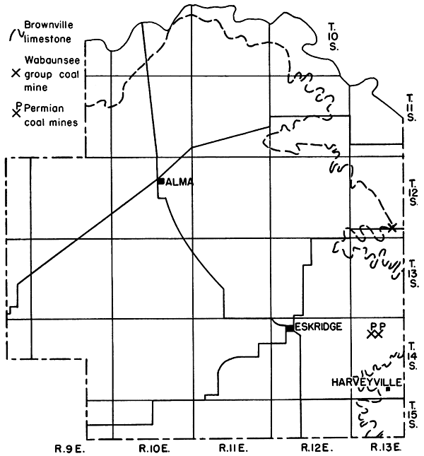
Lorton coal
According to Crane (1898, p. 137), a small amount of coal was produced along the ravines of the tributaries of Mission Creek, about halfway between Keene and Dover in Shawnee County. The coal ranges from 6 to 12 inches in thickness and was correlated by Crane as the same coal as the upper stratum of coal occurring 5 to 6 miles west of Topeka in the vicinity of Sugar Works or Bishop. Whitla (1940, p. 61) describes a dull black coal about 8 inches thick occurring in Wabaunsee County several miles west of Dover, which is just east of the county line in Shawnee County. According to him the coal is the Nyman coal. It is certain, however, that the coal mined as recently as 1939 by farmers on whose land it occurs is the Lorton coal between the Dover and Brownville limestones. The coal, seen in a stream bank 2.5 miles west and 0.6 mile north of Dover in the SW sec. 28, T. 12 S., R. 13 E. at the place probably referred to by Whitla, is 2 to 9 inches thick and lies immediately under an impure shelly fossiliferous limestone about 1 foot thick or is separated from it by 4 to 6 inches of clay. The coal occurs either as a single seam or is split into four or five units separated by clay seams. The coal and intervening clay seams have a combined thickness of 2 feet 2 inches and are underlain by light-gray shale.
Production and reserves
There has been no commercial coal mining of the Wabaunsee group coals in Wabaunsee County. The quantity mined by local residents is negligible. As far as could be observed, there is no Wabaunsee group coal worthy of being mined in the county; hence no proved and potential coals of this group are available.
Prev Page--Start of County Data || Next Page--References
Kansas Geological Survey, Geology
Placed on web Jan. 27, 2013; originally published December 1946.
Comments to webadmin@kgs.ku.edu
The URL for this page is http://www.kgs.ku.edu/Publications/Bulletins/63/06_county2.html