![]()
Prev Page--Introduction || Next Page--Coals
History of Mining of Wabaunsee Coals
It is impossible to determine accurately the exact date of the first mining of any of the Wabaunsee coals, but it is certain that the coal was known to pioneers at the time of the first settlements in the area for it was mined for local consumption. Mudge (1866, pp. 18-19), Swallow (1866, p. 56), and Hawn (Swallow, 1866, pp. 102, 120) as early as 1866 reported the mining of these coals in Atchison, Brown, Jefferson, Nemaha, Osage, Shawnee, and Wabaunsee counties and their outcropping in Coffey, Doniphan, Greenwood, and Jackson counties. Not only was the coal known to crop out and to have been mined, but Hawn (Swallow, 1866, p. 102) recognized more than one coal horizon in the Wabaunsee group of rocks in Brown County at this early date. Mead (1901, p. 208) stated that a Wabaunsee coal was mined in 1866 for neighborhood use on Coal Creek, 10 miles southwest of Emporia in Lyon County. Coal was first mined in Lyon County near Neosho Rapids in 1874 (Gray, 1875, p. 322), at Admire in 1886, and in the Neosho River bluffs 3 to 4 miles northwest of Emporia in 1886. According to interviewed residents of Chautauqua, Coffey, Cowley, Elk, and Greenwood counties, local mining in these counties was coincident with the first settlements near coal-bearing rocks and outcrops. In Osage County coal was mined before 1867 and in 1869 mining was begun on a commercial scale. By 1890 the Osage County coal-mining district, centered chiefly around Osage City, Burlingame, Scranton, and Carbondale, had become the most important coal-mining district in Kansas. As many as 75 mines were in operation in 1891 and approximately 3,000 persons were employed. Since 1893, however, the Osage district has steadily declined in importance, and in 1944 less than 200 men were working in the 8 active mines. More detailed information on the history of mining of the Wabaunsee coals is given under the various county discussions.
Geography of the Wabaunsee Coal-Bearing Area
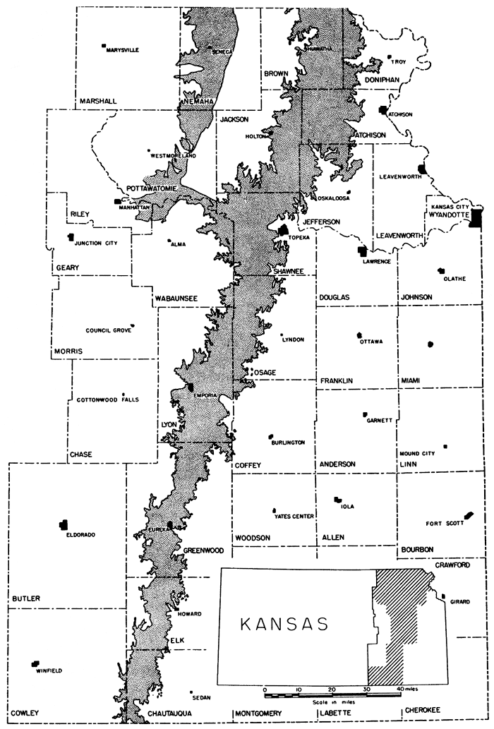
The Wabaunsee group of rocks crops out in a northeast-southwest belt in eastern Kansas. It extends from Doniphan, Brown, and Nemaha counties on the north to the Kansas-Oklahoma state line in Chautauqua and Cowley counties on the south (Fig. 1). Counties included in this area, which contains approximately 3,100 square miles, are Atchison, Brown, Chautauqua, Coffey, Cowley, Doniphan, Elk, Greenwood, Jackson, Jefferson, Lyon, Nemaha, Osage, Pottawatomie, Shawnee, and Wabaunsee. Physiographically, the Wabaunsee coal-bearing rocks are in the Central Lowlands Province of the Interior Plains. The part lying north of Kansas River Valley is known as the Dissected Till Plains, whereas the part lying south of this river is called the Osage Plains. The topography consists of a series of northeast-southwest terraces or cuestas, which are gently tilted westward. The eastern slope of the step-like surfaces is characteristically steep. The height of the escarpment varies with the thickness of the soft non- resistant rocks intervening between harder resistant limestone formations. Each escarpment marks the beginning of a new step or cuesta. Because of erosion, most of the escarpments are highly dissected and of crenulated pattern. In the Dissected Till Plains, the cuesta-like topography is generally obscured by a thick cover- ing of glacial drift. Local relief varies considerably, reaching as much as several hundred feet in Chautauqua and Cowley Counties. Streams cross the Wabaunsee rocks from west to east, except in Chautauqua County and north of Kansas River, where the main drainage courses parallel the escarpments.
Figure 1--Map of eastern Kansas showing outcrop area of the Wabaunsee group of rocks.
The most important towns in the Wabaunsee coal-bearing area are Hiawatha and Horton, Brown County; Sabetha and Seneca, Nemaha County; Valley Falls, Jefferson County; Topeka, Shawnee County; Burlingame and Osage City, Osage County; Emporia, Lyon County; Madison and Eureka, Greenwood County; Howard, Elk County; and Cedar Vale, Chautauqua County. The cities and towns are well served by federal and state highways, and the entire area is well traversed by railroads. Because of the good road system and the proximity of the Osage City-Burlingame coal district to the Kansas City industrial area, much of the Nodaway coal is hauled westward to distant places in Kansas and eastern Colorado by cattle trucks returning from Kansas City.
Prev Page--Introduction || Next Page--Coals
Kansas Geological Survey, Geology
Placed on web Jan. 27, 2013; originally published December 1946.
Comments to webadmin@kgs.ku.edu
The URL for this page is http://www.kgs.ku.edu/Publications/Bulletins/63/03_hist.html