![]()
Prev Page--Cenozoic || Next Page--Paleozoic
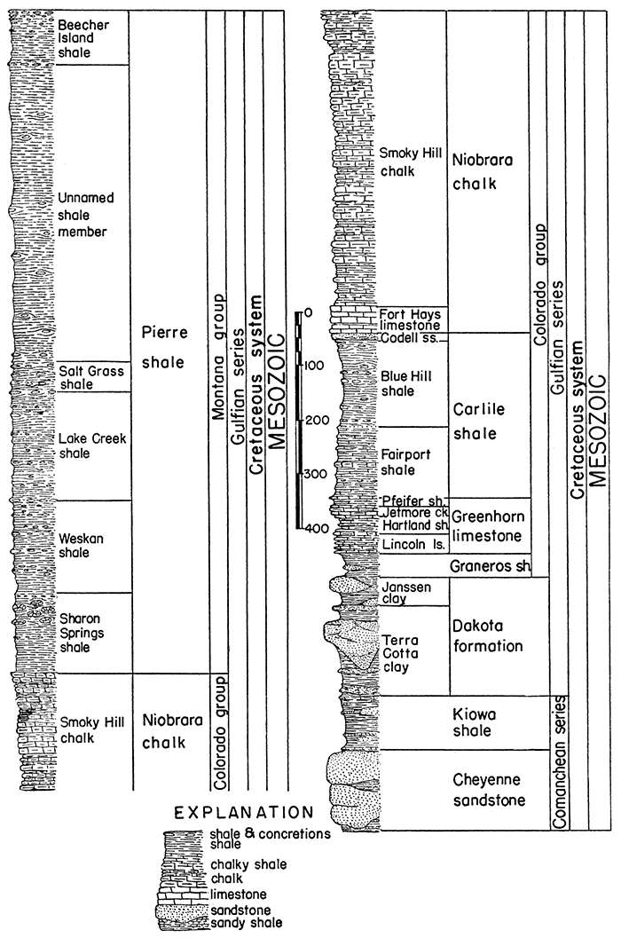
Mesozoic Rocks
Deposits of Mesozoic age comprising part of the geologic section of Kansas belong mostly to the Cretaceous system. These rocks cover many thousand square miles in the western part of the state. Older Mesozoic rocks, probably representing both the Jurassic and Triassic systems, are identified in well borings but are absent or, in the case of Triassic, somewhat doubtfully recognized very locally in surface exposures.
Cretaceous System
Rocks of Cretaceous age crop out at the surface or underlie much of central and western Kansas. These rocks are mostly marine, but deposits of supposed continental origin are found in the Cheyenne sandstone. and Dakota formation. Clayey and calcareous shale is the dominant constituent, but fine-grained platy and chalky limestone comprises most of the Greenhorn and Niobrara, and sandstones occur in the Cheyenne, Kiowa, Dakota, Graneros, and Carlile. In general, these rocks dip very gently westward, but locally dips may occur in any direction. Small outcrops of dark-colored igneous rocks that penetrate Permian strata in Riley County are possibly Cretaceous in age. The thickness of the Cretaceous system in Kansas is about 2,750 feet.
Gulfian Series
The upper part of the Cretaceous system is defined as the Gulfian series. At the beginning of Gulfian time, continental and littoral deposits accumulated in Kansas, but these conditions rapidly gave way to marine conditions and the shales and limestones constituting the Colorado and Montana groups were deposited. Thickness about 2,500 feet.
Montana group
Dark-colored marine shales that crop out and underlie the surface of northwestern Kansas. Thickness, 1,000 to 1,400 feet; average 1,235 feet.
Pierre shale--Shale, thin-bedded, black to dark gray, a few beds lighter in color, weathers to coffee-brown and gray; marine; contains concretions, selenite crystals, thin beds of bentonite, and locally chalky beds. Occurs in northwestern Kansas. Thickness, 1,000 to 1,400 feet; average 1,235 feet.
Beecher Island shale member--Shale, gray. Irregular concretionary limestone near top, limonite concretions throughout, thin beds of bentonite and limestone concretions in lower part. Characterized by the marine clams Tardinacara (Pseudoptera) fibrosa and Inoceramus sagensis, and the cephalopods Baculites grandis and Discoscaphites abyssinus. Thickness 100 feet.
Unnamed shale member--Shale, black to gray. Thickness, 500 to 600 feet, average 550 feet.
Salt Grass shale member--Shale, clayey, gray, containing numerous thin bentonite beds, limestone concretions, and concretionary limonite zones distributed throughout. Contains Baculites pseudovatus and Acanthoscaphites nodosus. Thickness 60 feet.
Lake Creek shale member--Shale, thin-bedded, flaky, dark gray and black; limestone concretions, zones of concretionary limonite, and locally gypsum are present. Contains Baculites compressus, Serpula wallacensis, and Acanthoscaphites nodosus. Thickness 200 feet.
Weskan shale member--Shale, clayey, gray. Bentonite beds more abundant in lower part, large limestone concretions and some limonite. Contains Serpula wallacensis, Acanthoscaphites nodosus, Anomia subtrigonalis, Ostrea, and Crassatella evansi. Thickness 170 feet.
Sharon Springs shale member--Shale, flaky, black, somewhat bituminous, large septarian and ordinary limestone concretions abundant in upper part; a few beds of light-gray shale. Thickness, 155 feet.
Colorado group
Shales, calcareous and noncalcareous, that crop out and underlie the surface of north-central, northwestern, and west-central Kansas. Limestone beds occur interbedded with the calcareous shales. These rocks are all of marine origin. Thickness, about 1,050 feet.
Niobrara chalk--Calcareous shale and chalk, soft, interbedded, light gray. Crops out in a belt trending generally northeast-southwest and extending from north-central to western Kansas. Thickness, 500 to 750 feet in Logan and Wallace counties; average 605 feet.
Smoky Hill chalk member--Shale, chalky, interbedded, gray, weathers white, yellow, and orange; contains limonitic concretions. Forms badland topography. Characterized by the marine clams Inoceramus (Haploscapha) grandis and Ostrea congesta. Thickness, 450 feet, to 700 feet in Logan county; average 550 feet.
Fort Hays limestone member--Chalk or chalky limestone, gray to cream-colored, massively bedded; thin beds of light to dark-gray chalky clay shale separate the massive chalky limestone beds. Extensively used for building stone. Contains Inoceramus deformis. Thickness, 50 feet in Phillips County, to 65 feet near the Colorado line; average 55 feet.
Carlile shale--Shale. chalky in lower part and containing thin chalk beds near the base, black fissile shale and large septarian concretions in upper part, fine-grained sandstone at top; marine. Occurs in northwestern and western Kansas. Thickness about 300 feet.
Codell sandstone member--Sandstone, fine-grained, and siltstone, somewhat calcareous, gray and tan; sharply defined at top but grading downward into dark-gray shale. Thickness, 3 feet in Ness County, 22 feet in northern Ellis County, to 25 feet in Hamilton County; average 15 feet.
Blue Hill shale member--Shale, clayey, gray-black to dark gray, noncalcareous; abundant ordinary and septarian concretions and selenite crystals. Thickness, 75 feet in Hamilton County to 200 feet in Russell County; average 160 feet.
Fairport chalky shale member--Shale, calcareous, and thin chalk beds, blue-gray to gray, weathers to light orange-tan; chalky limestones more abundant near base. Contains Ostrea congesta. Thickness, 85 feet in Russell County to 147 feet in Hamilton County; average 125 feet.
Greenhorn limestone--Chalky limestone and calcareous shale, interbedded, thin-bedded, light gray to dark gray, weathers yellow-gray to light gray; marine. Occurs in northwestern and western Kansas. Thickness, 85 feet in northern Barton County, 95 feet in Ellis County, to 132 feet in Hamilton County; average 100 feet.
Pfeifer shale member--Chalky shale and chalky limestone in alternating layers, "Fencepost limestone bed" at top, blue-gray, weathers to light-tan. In Hamilton County the Pfeifer shale member and the underlying Jetmore chalk member are thicker than farther east. They cannot be distinguished and have been together designated the Bridge Creek limestone member; having a total thickness of 74 feet. Thickness of Pfeifer shale is typically 19 to 21 feet in Ellis and Russell counties; average 20 feet.
Jetmore chalk member--Chalky shale and chalky limestone, interbedded, gray, weathers to light gray. Contains Inoceramus labiatus. Thickness, 20 feet (Russell and Ellis counties) to 25 feet; average 22 feet.
Hartland shale member--Chalky shale, a few thin beds of chalky limestone and bentonite, gray. Thickness, 23 feet in Kearny County to 35 feet in Ellis County; average 30 feet.
Lincoln limestone member--Chalky shale and chalky limestone, interbedded, light gray; beds of dark-gray hard crystalline limestone at base and top; shale contains thin beds of bentonitic clay. Member weathers to yellow-gray or yellow-tan. Thickness, 20 feet (Ellis County) to 35 feet; average 28 feet.
Graneros shale--Shale and clay shale, fissile, noncalcareous, blue-black, weathers to dark gray and coffee-brown; largely or entirely marine but mostly unfossiliferous; locally contains sandstone beds and beds of "clay ironstone"; selenite crystals abundant. Thickens southward across western Kansas. Thickness, 30 to 35 feet in Russell County to 65 feet near the Colorado line; average 45 feet.
The rocks which comprise the Dakota formation, Kiowa shale, and Cheyenne sandstone formerly were classed as the Dakota group. The use of this grouping has been discontinued.
Dakota formation--Clay, shale, siltstone, and sandstone, interbedded and lenticular; contains carbonaceous material, lignite, concretions of hematite and limonite, and locally quartzitic sandstone; white, gray, red, brown, and tan. Occurs in north-central and western Kansas. The Cockrum sandstone of southwestern Kansas is equivalent in age to part of the Dakota formation. Contains stratigraphic units formerly called "Rocktown channel sandstone," "Ellsworth formation," "Solomon formation," "Reeder sandstone," "Marquette sandstone," "Spring Creek clay," and others. Contains plant fossils and land vertebrates. Thickness, 100 to 300 feet; average 215 feet.
Janssen clay member--Clay, silt, and fissile shale, with lenticular sandstone, lignite, and lignitic clay common; gray to dark gray, contains concretionary hematite and limonite and beds of "ironstone." Central and north-central Kansas. Thickness, 30 to 80 feet; average 55 feet.
Terra Cotta clay member--Clay, shale, sandstone, and quartzitic sandstone, interbedded, red, gray, brown, and tan. Central and north-central Kansas. Sandstones are lenticular and weather brown, coarse-grained to fine-grained, abundant hematite and limonite concretions throughout. Quartzitic sandstone near top. Thickness, 70 to 220 feet; average 160 feet
Comanchean Series
The lower part of the Cretaceous system is defined as the Comanchean series. At the beginning of Comanchean time the Kansas area was being eroded and only upper Comanchean deposits occur in the state. The oldest Comanchean deposits in Kansas represent continental and littoral deposits laid down as the sea advanced northward. These nonmarine conditions rapidly gave way to marine conditions, and marine shales overlie the nonmarine and littoral deposits. These rocks crop out in a belt extending diagonally north to south across central Kansas, and at a few places in southwestern Kansas. Thickness, featheredge to 400 feet; average about 250 feet.
Kiowa shale--Shale, fissile, light gray, dark gray, and black, contains thin limestone beds throughout, with the Champion shell bed at the base in the type area. Locally, lenticular sandstones occur at any position within the shale; selenite crystals common. Abundant marine molluscan fauna in the thin limestones, shale, and sandstone. Probably contains stratigraphic units formerly called "Greenleaf sandstone," "Mentor beds," and others, and is in part equivalent to the "Belvidere formation," "Medicine bed," "Elk River beds," and others. Thickens across central and western Kansas toward the south and southwest. Typical thickness, 60 to 150 feet; average 100 feet.
Cheyenne sandstone--Sandstone, white, buff, gray, tan, red, yellow, and purple, with white, light gray, and buff dominant; and shale, light gray to dark gray. Sandstone, very fine-grained to coarse-grained, dominantly quartz, cross-bedded; shale, sandy and silty, cross-bedded, dark gray, contains plant remains. Cobble zone at base, locally conglomeratic; locally a zone of redeposited red Permian sand at base. Contains stratigraphic units formerly called "Stokes sandstone," "Lanphier beds," and "Natural Corral sandstone." Thickens westward in the subsurface. Maximum thickness exposed, more than 75 feet; maximum thickness in the subsurface, 300 feet; average 150 feet.
A major unconformity marks the base of the Cretaceous rocks. The Cretaceous rocks overlap northward on the pre-Cretaceous erosion surface, successively younger beds lying above the contact northward across the state, ranging from the Cheyenne sandstone in Comanche and Kiowa counties to the Dakota formation in Washington County. Rocks underlying the unconformable contact range in age from the Herington limestone in Washington County to beds believed to be of Jurassic age in northwestern Kansas.
Major unconformity
Figure 3--Generalized section of Cretaceous rocks in Kansas.
(?) Triassic System
Continental deposits of early Mesozoic age, identified as Triassic on the basis of vertebrate and plant remains, are widespread in western Texas and New Mexico. Mainly on lithologic grounds, certain outcrops in the panhandle of Oklahoma and southwestern Kansas are believed to be equivalent to the undoubted Triassic of areas farther south. Thickness in Kansas about 20 feet.
(?) Dockum group
Inasmuch as the Triassic rocks above mentioned, belonging to the late part of the period, are called Dockum group in Texas, this name is tentatively employed for the supposed Triassic of southwestern Kansas. Thickness, 20 feet.
Unnamed formation--Red siltstone, buff and white sandstone, and a small amount of gypsum, exposed at two places in the Cimarron valley in Morton County, are differentiated from other rocks of the region. They are believed to correspond to deposits in Texas County, Oklahoma, that are identified as Triassic. The maximum exposed thickness of these rocks in Kansas is about 40 feet but locally beneath the surface their thickness seemingly is greater; average 20 feet.
Regional unconformities and overlaps bring Cenozoic and Mesozoic rocks into contact with various Paleozoic formations.
Unconformity
Prev Page--Cenozoic || Next Page--Paleozoic
Kansas Geological Survey, Geology
Placed on web Jan. 18, 2017; originally published Oct. 25, 1944.
Comments to webadmin@kgs.ku.edu
The URL for this page is http://www.kgs.ku.edu/Publications/Bulletins/52_4/04_meso.html