![]()
Prev Page--Contents || Next Page--Cenozoic
Introduction
At the suggestion of geologists in Wichita who were charged with responsibility of arrangements for the annual meeting of the American Association of Petroleum Geologists in Wichita, in March 1935, the State Geologist prepared a tabular description of the rocks of Kansas. This chart was printed on large sheets and was distributed to geologists attending the convention. Additional copies were made available to most geologists and oil companies in Kansas through the agency of the Kansas Geological Society. Eventually the supply was exhausted, and copies were made by photostat or other means of reproduction. The usefulness of this tabulation, as indicated by the demand for it, has been called to our attention on numerous occasions, and the desirability of a revision or new summary on similar lines has been emphasized.
The present contribution differs from the earlier publication in treating only the rocks that are exposed at the surface in different parts of Kansas and in being arranged to go on successive pages rather than on a single large sheet. The omission of descriptions of subsurface rock units--that is, those which are not represented by outcrops anywhere in Kansas--may be considered to be a serious deficiency, especially from the standpoint of petroleum geologists who are concerned with exploration for oil and gas in Ordovician or other pre-Mississippian rocks of the state. Reason for this omission is the complexity of features belonging to these subsurface rocks, as now known in various parts of Kansas, and the present unreadiness of the authors to deal with these unexposed rocks satisfactorily. It may be possible to summarize subsurface stratigraphy of the Kansas region in a useful manner at a later time. The differentiation of outcropping rocks from those that are not exposed in the state is a convenient, if somewhat arbitrary, basis for limiting the scope of descriptions. The arrangement of material on pages, rather than in chart form, has the advantage of permitting flexible variation in space allotted to items, and the unwieldiness of a large chart is avoided. Effort has been made to preserve tabular features and conciseness, which are attributes of a stratigraphic chart.
Main Rock Divisions and Their Distribution
Outcropping rocks of Kansas are of Cenozoic, Mesozoic, and Paleozoic age. They are assigned to seven (or, according to alternative classification, six) geologic systems that embrace a time span of approximately 300 million years. They record the successive invasions of shallow seas that covered much or all of the state during many thousands of years. Some rock layers are of nonmarine origin, having been deposited by streams, air currents, or the still water of lakes. Such formations lack fossilized marine organisms, like those which are so abundant in many sea-laid strata of Kansas; they may contain leaves of land plants or traces of fresh-water life, or air-breathing animals. Also, there are numerous records of more or less widespread and prolonged erosion, when varying quantities of previously formed rocks were removed. These times of denudation indicate an emergent condition of the earth's surface in Kansas. They are defined by the local or regional absence of strata that are recognized elsewhere, and commonly there are irregularities along the contact of the sedimentary units that are separated by a hiatus in deposition. The hiatus is termed a disconformity if adjoining strata lie parallel, and it may be called an unconformity if locally or regionally the rocks on opposite sides of the break show, some divergence in structure or if there is evidence that interruption of deposition was very widespread and prolonged. Strictly speaking, however, the term unconformity embraces disconformity and gentle to strong angular discordance of beds. separated by an erosional break.
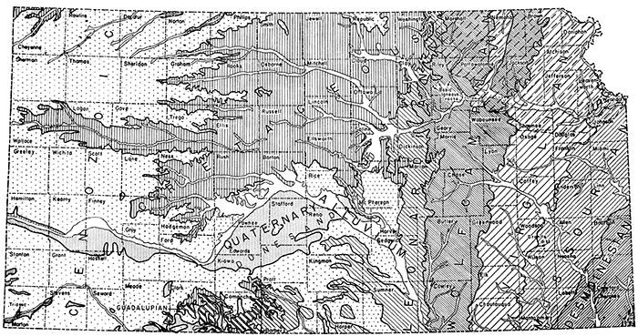
The distribution of outcrops belonging to all main divisions and representing many subdivisions of the rock column of Kansas is adequately shown on the half-million scale geologic map of the state, on which 1 inch equals approximately 8 miles (Moore and Landes, 1937). A generalized map showing rock outcrops is given in figure l.
Figure 1--Map showing distribution of main divisions of outcropping rocks of Kansas.
Distribution and structure of Cenozoic rocks
Deposits of Cenozoic age occurring in Kansas constitute a discontinuous thin veneer that broadly conforms to the east-sloping land surface. Excepting the widespread Tertiary deposits of western Kansas, the Cenozoic sedimentary units are so patchy and irregular that they may hardly be said to exhibit regional structure.
Distribution and structure of Mesozoic rocks
The outcrops of Mesozoic strata in Kansas are confined to the western two thirds of the state. They extend much farther eastward along the north border of Kansas (Marshall County) than in the south (Barber County); in central Kansas exposures are found eastward as far as Dickinson and Marion counties. Mesozoic rocks underlie thousands of square miles in western Kansas where Cenozoic formations cover the surface. In general, the Mesozoic strata are gently inclined toward the northwestern corner, of Kansas, dipping westward, northwestward, or northward.
Distribution and structure of Paleozoic rocks
The eastern and south-central parts of Kansas contain extensive outcrops of Upper Paleozoic rocks, chiefly Permian and Pennsylvanian. This is a region of roughly parallel belts of plains that are developed at the outcrop of weak rocks and on the upper surface of some gently inclined hard formations. The plains are separated by hilly country that terminates eastward in a more or less prominent escarpment. The general trend of these escarpments is south-southwest across eastern Kansas. The Flint Hills, which are formed by Lower Permian strata, are an example.
At the outcrop, Paleozoic strata in Kansas shaw a very gentle west or west-northwest dip that ranges mostly from 15 to 35 feet to the mile. Locally, there are dips in other directions or the layers may be quite horizontal; nowhere are the strata steeply inclined. A noteworthy belt of distinct although gentle easterly dips may be traced across the state from the vicinity of Arkansas City in the south to the neighborhood of Seneca in the north; this defines the east limb of the anticlinal structure that overlies the buried Nemaha Ridge. Drilling along this anticline in south-central Kansas has led to the discovery of important oil and gas fields. Faults having small displacement have been observed in a few places, but nowhere in Kansas is faulting a very noticeable feature of the rock structure.
Igneous rocks
Although outcropping rocks of Kansas are almost exclusively of sedimentary nature, rocks of igneous origin occur in at least two areas. It is not possible to determine the age of these rocks with any exactness, and consequently they cannot be fitted satisfactorily into a tabular description. In Woodson County boulders of granite-like rock are found in association with partly metamorphosed Pennsylvanian sedimentary rocks. The igneous rock is evidently a dike-like intrusion that invaded the strata some time after Late Pennsylvanian time. In Riley County there are at least three small outcrops, each less than an acre in extent, that furnish record of intrusion of dark-colored igneous rock into Lower Permian strata. The known exposures of this igneous rock are several miles distant from one another. Based on very insecure considerations, it is supposed that the igneous rocks of Kansas just noted may be of Cretaceous age.
Prev Page--Contents || Next Page--Cenozoic
Kansas Geological Survey, Geology
Placed on web Jan. 18, 2017; originally published Oct. 25, 1944.
Comments to webadmin@kgs.ku.edu
The URL for this page is http://www.kgs.ku.edu/Publications/Bulletins/52_4/02_intro.html