Kansas Geological Survey, Bulletin 52, Part 1, originally published in 1944
Originally published in 1944 as Kansas Geological Survey Bulletin 52, Part 1. This is, in general, the original text as published. The information has not been updated.
A field reconnaissance of Pleistocene deposits in north-central Kansas was made during the summer of 1943. The Sanborn formation of Pleistocene age mantles the uplands of much of this part of the state, and terrace deposits occur along the major valleys. The Sanborn formation consists of an upper gray silt bed which is persistent over the entire area and exhibits a unique topographic expression, an underlying soil zone that occurs only in north-central Kansas, and pre-soil zone deposits consisting of a wide variety of lithologic types. Seventeen measured sections of these Pleistocene beds are given.
The vertebrate fossils listed from the Sanborn formation are Canis lupus Linnaeus, Citellus richardsonii (Sabine), Cynomys vetus Hibbard, Cynomys ludovicianus (Ord), Geomys sp., Microtus cf. pennsylvanicus (Ord), Equus sp., and Platygonus leptorhinus Williston. Mollusks are listed from the upper gray silt bed and from the pre-soil zone deposits.
Deposits now known to be of Pleistocene age have been recognized for a number of years at scattered localities in north-central Kansas. These deposits in the northern two tiers of counties south of the Nebraska line have been referred to in several published papers (Darton, 1905, p. 155; Landes, 1928; Landes, 1930, p. 14; Wing, 1930, pp. 14, 15; Elias, 1931; Elias, 1937; Landes and Keroher, 1942, pp. 283, 284). These sediments have not been studied regionally or in detail, their vertebrate fossils have not been discussed, and over much of the area these beds have not been assigned to named formations or correlated with the described strata in adjacent areas. Beds of similar character in Nebraska have been studied and described by Lugn (1935,, pp. 128-168). In 1931 Elias (1931, pp. 163-181) named and described the Sanborn formation from exposures in the northwestern corner of Kansas, and later he (Elias, 1937, p. 7) briefly described the occurrence of this formation farther to the east in Rawlins and Decatur counties. The upper gray loess part of the Sanborn and its molluscan fauna have recently been studied in Decatur, Rawlins, Sheridan, Sherman, and Thomas counties by Leonard and Frye (1943).
In 1942, studies of the ground-water resources of Thomas and adjacent counties in northwestern Kansas were undertaken cooperatively by the State Geological Survey of Kansas and the Federal Geological Survey. Much of the upland area of this part of the state was found to be mantled with Pleistocene loess which comprises the upper part of the Sanborn formation. In order to obtain a better understanding of the stratigraphy and regional relationships of these beds, a field reconnaissance of the Pleistocene deposits in a part of the area in north-central Kansas shown in figure 1 was made in 1943 by Hibbard and Frye. In this work the vertebrate fossils were studied by Hibbard; the lithology, stratigraphic relations, and physiographic expression of the deposits were studied by Frye; and the fossil mollusks were studied by Leonard.
During the course of the field work a number of lithologic sections of these deposits were measured. These descriptive sections are grouped together at the end of this paper for ease of reference. The approximate location of each measured section is shown in figure 1; they will be referred to in the text by number.
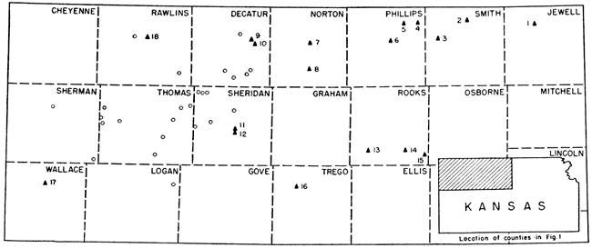
Fig. 1--Map of north-central and northwestern Kansas. Solid diamonds and adjacent numbers indicate localities where sections were measured and/or fossils collected. Open circles indicate localities from which snails have been reported by Leonard and Frye (1943).
The Sanborn formation was named in 1931 by Elias (1931, p. 163) from exposures in northwestern Cheyenne County, Kansas, south of the town of Sanborn, Nebraska. The name Sanborn formation was "proposed for the loess, with some gravel and sand at the base, which is widely distributed on the divides in western Kansas. The name is intended as a substitute for the old term 'Tertiary marl,' or 'Plains marl' introduced for this formation by Robert Hay" (1895, pp. 569-577, 580-584). In 1935 Lugn (p. 196) objected to the use of Sanborn as a formational unit on the grounds that beds of equivalent age in Nebraska had been subdivided into several distinct formations. In 1937, however, Elias assigned beds in Rawlins and Decatur counties, Kansas, to the Sanborn formation, and in 1943 Leonard and Frye used the term Sanborn to refer generally to loess and underlying sand and gravel beds of Pleistocene age over northwestern Kansas.
Elias' term Sanborn is used in this paper to refer to essentially the entire Pleistocene section exposed in north-central and northwestern Kansas, although some distinct terrace beds of local extent have not been included within it. This term is used, for the reasons discussed below, in spite of the fact that in some localities beds have been studied that are probably stratigraphic equivalents of the Peorian and Loveland as described by Lugn in southern Nebraska. The soil zone that separates Lugn's lower red Loveland from his upper gray to tan Peorian is quite distinct and well developed in northern Kansas from western Jewell County to western Norton County, but west and south of this area the soil zone becomes indistinct and in many places (note measured section no. 17 in Wallace County) is nonexistent. As this bed is the stratigraphic marker between these two units, its absence leaves their contact indistinct. The upper gray loess is a persistent lithologic unit over the entire area studied, but the texture, color, and composition of the deposits below the soil zone (or in its absence below the gray loess) range within wide limits. The red sand and silt beds stratigraphically below the soil zone resemble the deposits described by Lugn as Loveland in Nebraska only in a small area south of the Nebraska line where they occur below a well-developed soil zone. Furthermore, there exists some doubt as to the complete age equivalency of the beds in southwestern Nebraska called Peorian and Loveland and the deposits at the respective type localities. For these reasons, it seems most advisable to retain Sanborn as the formational unit for the Pleistocene deposits in northern Kansas until the deposits in that area have been studied in more detail.
Beds herein assigned to the Sanborn formation have been observed from western Jewell County westward for more than 200 miles to Yuma County, Colorado. Although the lower part of this formation is discontinuous, the upper gray silt or loess is widespread and mantles the headwater areas of the southern tributaries to Republican river, the headwater areas of Saline and Solomon rivers, and the north fork of Smoky Hill river. In north-central Kansas the Sanborn attains its maximum development on the divide areas between Republican and Solomon rivers and between Solomon and Saline rivers. Thin deposits of loess have been observed capping the uplands at scattered localities eastward from central Jewell County, and thick upland loess occurs in extreme eastern Kansas along Missouri river valley. This eastern loess may be equivalent in age to the extensive gray loess of the Sanborn, but as it has not been studied by us no definite correlation is attempted.
In the eastern part of the area shown in figure 1, Pleistocene terrace deposits occur along the major stream valleys, especially those of the Solomon and the Saline. In this part of the area the deposits studied and herein referred to the Sanborn formation are essentially upland deposits. Westward across north-central Kansas the depths of the major valleys diminish and the upland divide deposits encroach on the valley sides so that from Thomas County westward the Sanborn deposits merge with and include the terrace deposits (Leonard and Frye, 1943). The terrace deposits along the major valleys of north-central Kansas are not discussed in this paper, although a measured section (no. 15) of the terrace deposits along Paradise creek and of a minor upland terrace deposit (Measured section no. 13) in Rooks County are included for comparison.
Most of the surface of northwestern Kansas and an appreciable percentage of the surface of the north-central part of the state is underlain by the upper gray loess of the Sanborn formation. The lower Sanborn beds immediately underlie the surface of only a small fraction of this area. The topography of the area is hardly that which one would expect to develop on loess. Plate 1C is a view taken from a drill derrick in eastern Thomas County and shows the typical topography of the true High Plains part of the region. It is a nearly flat and almost featureless upland plain underlain by gray Sanborn loess to a depth of 40 to 75 feet. Eastward the flat upland areas decrease in width and the interstream areas consist of rolling topography and gentle slopes.
Plate 1--Typical topography as developed as developed on the upper Pleistocene Sanborn loess. A, Valley side slope in east-central Norton County showing step-like ("cat-step) erosion and steep channel side bank. B, Valley slopes in Sanborn loess in west-central Rawlins County. A prominent "double escarpment" has developed along the valley sides in this homogeneous material. C, Flat upland surface underlain by Sanborn loess in east-central Thomas County. (Photographs by Frye.)
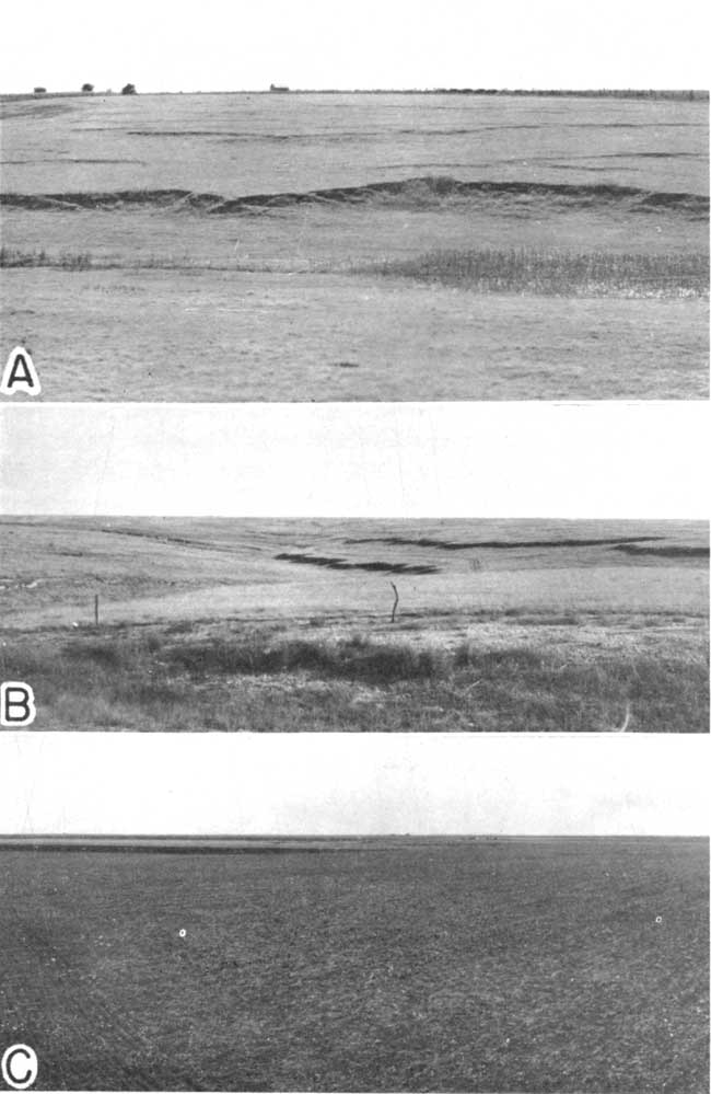
The valley side slopes underlain by loess along the tributary valleys are marked by characteristic types of slope development. These slopes do not present smooth even descents from divide to channel but are typically broken by one or more minute escarpments, even though the material on which they are developed is completely homogeneous loess and the natural cover of vegetation consists almost entirely of native short grass. One general type of slope interruption consists of nonpersistent and numerous low steps commonly 8 to 10 inches in height, as shown in plate 1A. This surface feature has been referred to as "cat-step erosion" and may be due to differential slumping of the unconsolidated silt. Such an explanation is quite superficial, however, and it is believed that these features deserve further study.
The second type of slope interruption, illustrated in plate 1B, consists of one or more persistent low escarpments extending along the valley sides. The individual escarpments attain a maximum height of more than 5 feet; they parallel or gradually diverge from the channel, and in a downstream direction their height above the channel floor gradually increases. These escarpments extend as much as several miles in an unbroken sinuous line along some of the major tributary valleys. One significant relationship is that in many valleys the channel side escarpments converge upstream and end abruptly in a small "box head." The "cap rock" of the escarpments and "box heads" consists of the tight sod of short grass. Some valleys have been observed which exhibit as many as three of these escarpment systems and have the appearance of multiple cycle valleys.
Even though these valleys have cut their entire depth into unconsolidated and homogeneous silt, it is hardly conceivable that such features are the result of slumping. One possible explanation is that the system has been controlled by lateral channel shifting or by periods of excessively rapid down cutting in the master stream. Either could suddenly lower the local base level of control for the tributary stream and thus cause a notch or "box head" to be initiated at the channel bank. As this "box head" or intermittent waterfall retreated headward by the undercutting of the sod "cap rock," its resultant channel-side escarpments were also extended headward and the space between them was progressively widened by slope wash and processes of pedimentation. If this process were repeated at a later date, a second cycle of escarpments might be initiated that would migrate headward within the older ones. These physiographic processes have operated rapidly as is demonstrated by the fact that the loess in which these features are developed is of upper Pleistocene age.
The upper gray loess of the Sanborn formation consists of well-sorted silt and very fine sand. It is massive, unconsolidated, and ranges in color from ash-gray to light cream-tan. From Decatur County westward it is somewhat calcareous but nearly free from concretions or nodules. Eastward from Decatur County the loess becomes more calcareous, and concretions progressively increase in abundance. This is probably due in part to the fact that from Norton County eastward the bedrock consists largely of Cretaceous chalks of the Niobrara formation, whereas to the west the underlying bedrock is the Pierre shale and the Ogallala formation. Also, the average annual rainfall increases by nearly 100 percent from west to east across this area. This loess, where not extensively removed by erosion, probably ranges in thickness from 40 to 75 feet. Elias (1931) has reported 180 feet of Sanborn (mostly loess) in Cheyenne County, and it probably attains a maximum thickness of more than 100 feet in Rawlins and Sherman counties, Kansas, and Yuma County, Colorado.
Only a few vertebrates are known from the upper gray Sanborn silt in Kansas. Some of the first specimens known from this horizon were collected prior to 1894 (Williston, 1897) from an excavation dug to produce "clay" for a brickyard at Goodland in Sherman County, Kansas. During the summer of 1943, vertebrates were collected from this bed in north-central Kansas by Hibbard, J. C. Frye, and Ruth Frye. The vertebrates known to date from this horizon in Kansas are as follows.
Canis lupus Linnaeus
Canis lupus LINNAEUS, 1758, Syst. Nat., 10th ed., vol. 1, p. 39.--GOLDMAN, 1937, Jour. Mammalogy, vol. 18, no. 1, p. 37.
A good skull and lower jaws of a wolf (KUMVP no. 2851) were collected at Goodland, Sherman County, Kansas, about 1894 and were mentioned by Williston (1897, p. 304; 1898, p. 93.). He made the following comment concerning the specimen: "A complete skull and other parts of the skeleton are in the University collection obtained from near Goodland, in apparently the same deposits as those which yielded the Platygonus remains." The other parts of the skeleton have not been located, although Mr. H. T. Martin told the senior author that the skull and lower jaws were taken from the same excavation that yielded the remains of Platygonus leptorhinus Williston at Goodland. The old excavation has not been examined by us, but the examination of exposures near Goodland indicates that the skull probably was taken from the silt above the soil zone. Since the pit was only 12 feet deep, the fossils taken from the excavation most likely came from the upper part of the silt, as this bed exceeds 20 feet in thickness in the vicinity of Goodland. The matrix still adhering to the Platygonus bones is similar to the silt found at other localities above the soil zone. (See O. P. Hay, 1924, p. 158, for more detailed description and exact location of the pit at Goodland, Kansas).
Citellus richardsonii (Sabine)
Arctomys richardsonii SABINE, 1822, Linnean Soc. Trans., vol. 13, p. 589.
A weathered right and left jaw (KUMVP no. 6831) of a ground squirrel which is considered as the above form were collected from the east side of U. S. Highway 238, locality no. 7, south of Norton, Kansas. The jaws were found 2.5 feet above the soil zone and at the base of the lower snail zone in bed 4 of the measured section.
At the same locality a right maxillary (KUMVP no. 6830) of the same ground squirrel was collected from bed 4, at the position of the upper snail zone, 21 feet above the soil zone (bed 3). The maxillary contains P4-M3 which has an anteroposterior diameter of 8.9 mm.
Cynomys ludovicianus (Ord)
Arctomys ludoviciana ORD, 1815, Guthrie's Geography, 2d Am. ed., vol. 2, p. 242. Description on page 302.
Part of a prairie dog skull (KUMVP no. 6838) was collected from the west side of U. S. Highway 238 at locality no. 8, Norton County. The specimen recovered cannot be distinguished from the prairie dog now found living in Kansas. The fragmentary skull was taken from bed no. 5 of the measured section. As shown in the measured section, volcanic ash occurs above this bed. The ash appears to have been redeposited and a probable source for it occurs across the valley to the southwest where a thick deposit of older ash can be observed in place.
Microtus cf. pennsylvanicus (Ord)
Mus pennsylvanica ORD, 1815, Guthrie's Geography, 2d Am. ed., vol. 2, p. 292.
An M1 referable to the above species (KUMVP no. 6832) was collected from exposures along the north side of the road (bed 3) at locality no. 2 in Smith County. The specimen was found 4 feet above the soil zone. The tooth consists of a posterior loop, six alternating closed triangles and the seventh alternating triangle opens into the small anterior loop. The anterior loop is srnaller than that loop in the specimens of Microtus pennsylvanicus collected in the Jones fauna (Hibbard, 1943, pp. 187, 188) of Meade County, Kansas, or in the specimen from the Rezabek fauna (Hibbard, 1943a) of Lincoln County, Kansas, referred also to M. pennsylvanicus.Equus sp.
Fragments of a horse tooth (KUMVP no. 6837) were collected from the massive gray silt (bed 4) 4 feet above the soil zone at locality no. 3, Smith County, Kansas.
Platygonus leptorhinus Williston
Platygonus leptorhinus WILLISTON, 1894, Kansas Univ. Quart., vol. 3. no. 1. p. 27.
Williston reported nine of these peccaries taken from a pit near a brickyard at Goodland, Sherman County, Kansas. The bones were found 9 feet below the surface, and are here considered as coming from the upper part of the upper gray silt of the Sanborn. Williston (1897, p. 303; 1898, p. 92) later referred this form to Platygonus compressus Le Conte. Gazin (1938, pp. 43-46) recognizes P. leptorhinus as a valid species.
Williston (1898, p. 93) reported that bones of the living Citellus trideceimlineatus (Mitchill) were found associated with the bones of Platygonus, although he says, "I suspect that they are from old burrows."
During the summer of 1943 snails were collected by C. W. Hibbard, John C. Frye, and Ruth Frye from the upper gray-tan silt of the Sanborn formation at nine of the localities shown in figure 1, and two unnumbered localities in Graham County. These collections extended the known geographic range of the upper Sanborn molluscan fauna by more than 100 miles toward the east and southeast. Seven forms are listed that did not occur in the collections from this bed reported previously by Leonard and Frye (1943). A summary of the molluscan fauna is given in figure 2 [Figure 2 available as an Acrobat PDF file]. Snails collected from the upper bed of the Sanborn formation are listed below.
| Gastropoda |
|---|
| Carychium exile H. C. Lea Cochlicopa lubrica (Müller) Discus cronkhitei anthonyi (Pilsbry) Euconulus fulvus (Müller) Pupilla blandi Morse Pupilla hebes (Ancey) Pupilla muscorum (Linnaeus) Retinella sp. Succinea grosvenori Lea Vallonia costata (Müller) Vallonia pulchella (Müller) Vertigo coloradensis Cockerell Vertigo gouldii Binney Zonitoides arboreus (Say) |
A soil zone at the base of the gray loess was definitely recognized in exposures in Jewell, Smith, Phillips, Norton, Decatur, Sheridan, and Rooks counties (pl. 2). The thickness as shown by the measured sections ranges from 3 feet to 4.8 feet and averages 3.7 feet. The zone consists of sandy silt loam, more sandy in the west, which ranges in color from brown or purple-black in the east to gray-brown in Decatur County. In many places the upper and lower contacts are indistinct and in measured section no. 9 in Decatur County the presence of a soil zone is questionable.
Plate 2--Pleistocene exposures showing the prominent soil zone and upper gray loess. A and B, Exposures along east side of highway in the NW sec. 11, T. 3 S., R. 23 W., Norton County, Kansas. Note measured section no. 7. The prominent soil zone is shown across the middle of the exposures. C, Exposure along south side of highway U.S. 36 in the NE sec. 3, T. 3 S., R. 27 W., Decatur County, Kansas. Note measured section no. 10. (Photographs by Frye.)
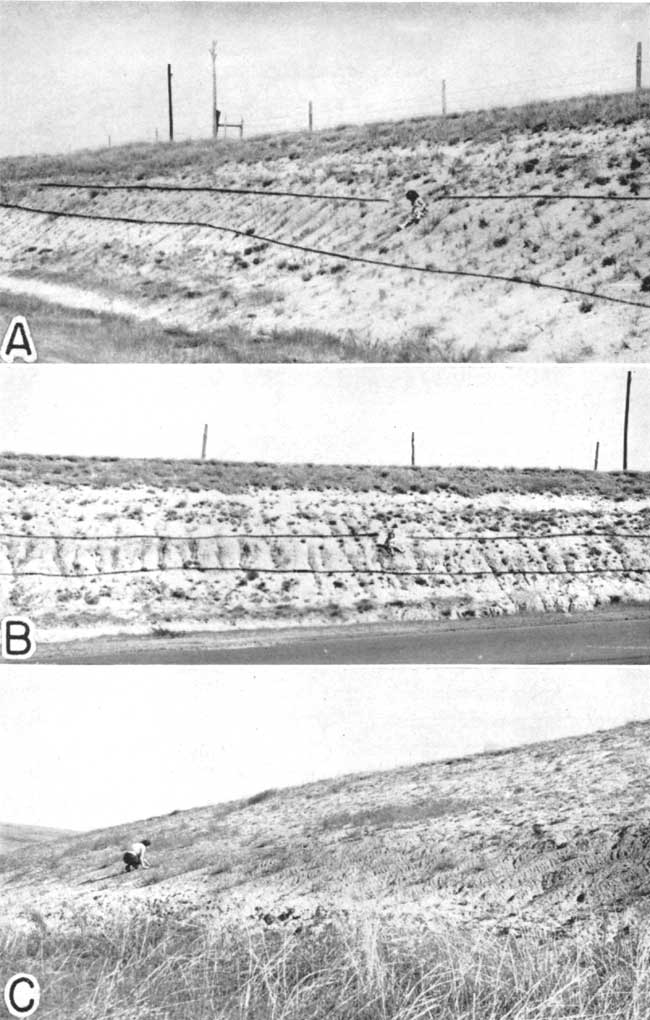
The configuration of the soil zone surface is in general a reflection of the pre-existing topography. Pre-Sanborn and post-Ogallala erosion produced a sharp topography that abounded in steep slopes. This topography was greatly subdued by pre-soil zone Pleistocene deposition. The soil zone now can be observed resting directly on Ogallala beds only a few hundred yards distant from a thick sequence of pre-soil zone Pleistocene deposits. At some places, such as at locality no. 6 in Phillips County, the pre-Sanborn topography coincides in general with the present topography, the pre-soil zone Sanborn deposits lap against an Ogallala hill, the soil zone slopes in the same direction as the surface, and all is mantled with gray loess. In general, the topographic relief on the soil zone surface was much less than the present relief, and the present topography is probably not as sharp as that on which the Sanborn rests.
The following vertebrates were collected from the soil zone during the summer of 1943.
Citellus richardsonii (Sabine)
Remains of this ground squirrel were found in the soil zone (bed 3) in an old burrow at locality no. 7 in Norton County, Kansas. Parts of three skeletons were recovered (KUMVP no. 6882).
Two right rami (KUMVP no. 6867) bearing P4-M1 were taken from the soil zone at locality no. 16 in Trego County, Kansas,, 6.8 miles west of Wakeeney on the north side of U. S. Highway 40. The anteroposterior diameter of P4-M3 of the two jaws is 9.3 and 9.35 mm.
Cynomys ludovicianus (Ord)
A maxillary of a prairie dog (KUMVP no. 6868) bearing an M3 was taken at locality no. 16, Trego County, Kansas. Associated with the prairie dog were fragments of an elephant tooth which were too badly weathered and shattered for identification.
The Sanborn beds that occur stratigraphically below the soil zone display a wide variety of lithology. It should be pointed out again that in large areas in Thomas, Sherman, Sheridan, Cheyenne, Rawlins, and other counties the gray loess lies directly on the Tertiary or Cretaceous bedrock; in other areas the soil zone is absent and Pleistocene sand and gravel underlie the gray loess. For the most part the pre-soil zone deposits are definitely of a water-laid type, although in a few measured sections, notably nos. 2 and 3 in Smith County, no. 4 in Phillips County, and no. 7 in Norton County, deposits that may be of eolian origin were found underlying the soil zone. The discontinuous nature of these strata, their wide lithologic variation, and their relation to the pre-Sanborn topography indicate that they were deposited in a variety of ways and may not all be of the same age. As was suggested by Leonard and Frye (1943), some of these coarse sediments probably represent terrace deposits along former major drainage ways. This type of deposit, including coarse-textured material probably derived from some distance west of the present locality, is shown in measured section no. 17 in Wallace County. The beds described in measured section no. 8 in Norton County may represent similar terrace deposits, and measured sections nos. 10 in Decatur County and 11 in Sheridan County probably represent either terrace or lacustrine deposits. At a number of localities, particularly in the eastern part of the area (note measured sections nos. 5 and 6 in Phillips County and 14 in Rooks County), the pre-soil zone strata seem to represent local slope wash deposits or minor gully fillings that consist largely of abraded grains and pebbles of chalk and chalky shale. The beds shown below the soil zone in measured section no. 1 in Jewell County seem best explained as slack water deposits that accumulated on a broad flood plain or in a lake.
The lower Sanborn sediments range in color from red to light gray, with red, pink, and light brown predominating. The greatest thickness measured was 46.8 feet at locality no. 1 in Jewell County. The lower contact was not observed at this locality, however, and the maximum thickness throughout the area is believed to be considerably more than 50 feet.
Most of these vertebrate fossils collected during the season of 1943 from the Sanborn formation in north-central Kansas were taken from below the soil zone. The vertebrate fossils known from the lower Sanborn of Kansas are as follows.
Citellus richardsonii (Sabine)
Four lower jaws of a ground squirrel considered as belonging to the above species were collected from near the base of the exposure in bed 1 at locality no. 3 in Smith County, Kansas. Specimen KUMVP no. 6833 is a left jaw containing P4-M3. The anteroposterior diameter of the molar series is 9.2 mm. Specimen no. 6834 is the right and left jaw bearing P4-M3, whose anteroposterior diameter is 9.2 mm. Specimen no. 6835 is a right jaw bearing P4-M3, with an anteroposterior diameter of 9.9 mm.
At locality no. 6 in Phillips County, Kansas, a left jaw (KUMVP no. 6883) bearing P4-M3, with an anteroposterior diameter of 9.1 mm, was taken 6 feet from the base of the measured section in bed 1.
A right jaw (KUMVP no. 6829) and other skeletal elements of this ground squirrel were taken from bed 2 at locality no. 7 (along U. S. Highway 283) south of Norton, Norton County, Kansas. The upper incisor of a species of Geomys was found associated with them. To the west in Decatur County at locality no. 10 a fragmentary skull and two right lower jaws of this ground squirrel were collected 3 and 4 feet below the soil zone in bed 2. Specimen KUMVP no. 6825 possesses a complete dentition. The anteroposterior diameter of P4-M3 is 9.4 mm.
Cynomys vetus Hibbard
Cynomys vetus HIBBARD, 1942, Kansas Geol. Survey, Bull. 41, pt. 6, p. 268.
The type of this prairie dog, collected by Herbert A. Waite in sec. 3, T. 1 S., R. 10 W., Jewell County, Kansas, is the onlv specimen of this species known to date. It was taken from below the horizon of the soil zone.
Cynomys ludovicianus (Ord)
A left ramus and isolated upper teeth (KUMVP no. 6826) were collected 6 feet below the soil zone in bed 2 at locality no. 10 in Decatur County, Kansas. This specimen cannot be distinguished from the prairie dog now living in Kansas. The remains of a bird (KUMVP no. 6822), which are now being studied by Dr. Loye Miller of the University of California at Los Angeles, were found associated with the prairie dog.
A skull of Cynomys ludovicianus (KUMVP no. 3968) was collected by Dr. M. K. Elias from a lower Sanborn exposure 1.65 miles north and one-fourth mile west of Kanona, Decatur County, Kansas (reported by Hibbard, 1937). Although Elias (1931, p. 180) had not found fossils in the Sanborn loess at the time of his description of the formation, he did observe the presence of terrestrial gastropods in the yellowish-buff loess in Decatur County above the horizon from which he collected the prairie dog.
Remarks--The specimen of Citellus richardsonii reported by Green (1941) from Sheridan County, Kansas, cannot be definitely assigned to a given horizon in the Sanborn formation as the geology of this area has not been studied and Green did not measure a stratigraphic section at the locality. He reports that numerous Pleistocene mollusks were found associated with the jaw.
All of the vertebrate fossils, with the exception of Cynomys vetus which is known only from the type, are here considered as late Pleistocene both from the study of the deposits and from the known occurrence of such forms in southwestern Kansas.
In Meade and Clark counties, where extensive collections have been made from the Pleistocene beds, Citellus richardsonii, Cynomys ludovicianus, and Microtus pennsylvanicus have been found to occur only in late Pleistocene deposits, such as the Jones fauna, the upper Kingsdown silt, and local sinkhole fills. Platygonus has a long vertical range, and is known from the Pliocene, older Pleistocene deposits, and the upper Kingsdown silt from southwestern Kansas. Platygonus leptorhinus has not been recognized from that region, although numerous fragments of Platygonus have been collected from the late Pleistocene deposits of that area.
Snails were collected from the Sanborn beds below the soil zone at only three localities, one in Jewell County and two in Phillips County. Clams were also obtained at the Jewell County locality. The mollusks collected from below the soil zone are listed below.
| Pelecypoda |
|---|
| Anodonta sp. Sphaerium sp. |
| Gastropoda |
| Hawaiia miniscula (Binney) Helisoma antrosum (Conrad) Helisoma trivolvis (Say) Physa sp. Pupoides marginatus (Say) Succinia grosvenori Lea Vallonia costata (Müller) |
Intensive and detailed studies of the Pleistocene deposits of north-central and northwestern Kansas have not been possible. The foregoing data, which are based on a field reconnaissance of less than two weeks, serve to extend the range of the molluscan fauna of the Sanborn formation previously reported, present some facts concerning the stratigraphy and physiographic expression of these beds, and report the known vertebrate fossils of the formation in Kansas.
| 1. Section measured in the NW sec. 2, T. 2 S., R. 9 W., along east side of road, Jewell County, Kansas | Feet | ||
|---|---|---|---|
| Sanborn formation | |||
| 9. | Silt and soil, dark gray to brown | 4.0 | |
| 8. | Silt, massive, gray, with abundant pipy concretions of calcium carbonate throughout | 8.0 | |
| 7. | Soil zone, massive, dark gray-brown, gradational at top and bottom | 4.5 | |
| 6. | Silt and fine sand, thin-bedded and interbedded with clay. At top massive and red-brown. Clams occur in lower part | 15.0 | |
| 5. | Clay and silt, massive, blocky, light red-brown | 2.5 | |
| 4. | Silt and fine sand, laminated to thick-bedded, a few beds of red-brown plastic clay. Upper and lower contacts are uneven. Contains snails | 10.0 | |
| 3. | Silt, clay, and fine sand, wavy-bedded in lower part and massive at top | 9.5 | |
| 2. | Clay, silty, blocky, red-brown, containing concretions of calcium carbonate. Weathers to a checked surface | 4.8 | |
| 1. | Silt, bedded, gray. with thin beds of red and gray clay | 5.0 | |
| Thickness of exposed Pleistocene strata | 63.3 | ||
| 2. Section measured in the SE SE sec. 28, T. 1 S., R. 13 W., Smith County, Kansas | Feet | ||
|---|---|---|---|
| Sanborn formation | |||
| 3. | Silt, massive, gray, with a gray-tan zone at base and a few thin tan zones throughout. Contains pipy calcareous concretions, small clusters of botryoidal concretions of calcite, and a few concretions of limonite. Weathers to ash-gray. Vertebrate fragments present; snails occur 5 to 8 feet above base | 12.0 | |
| 2. | Soil zone, massive, purple-brown to dark-gray, weathers purple, massive, porous. A few patches of calcium carbonate occur on blocky surfaces | 4.8 | |
| 1. | Silt, with some clay and very fine sand, massive, red-brown, weathers to a blocky surface | 5.0 | |
| Thickness of exposed Pleistocene strata | 21.8 | ||
| 3. Section measured in the NE SE sec. 31, T. 2 S., R. 14 W., Smith County, Kansas | Feet | ||
|---|---|---|---|
| Sanborn formation | |||
| 4. | Silt, massive, gray, contains abundant pipy concretions of calcium carbonate and a few concretions of limonite in the upper part | 11.0 | |
| 3. | Soil zone, dark gray-brown to black, spotted with calcium carbonate along joint surfaces, blocky | 3.2 | |
| 2. | Silt, massive, buff to buff-gray. Contains concretionary masses of intergrown bladed calcite crystals | 2.0 | |
| 1. | Silt and very fine sand, massive, buff. Rests unconformably on weathered upper surface of Cretaceous rocks. Vertebrate fossils collected from 1 foot above base | 4.1 | |
| Thickness of exposed Pleistocene strata | 20.3 | ||
| 4. Section measured in the NW sec. 9, T. 2 S., R. 16 W., Phillips County, Kansas | Feet | ||
|---|---|---|---|
| Sanborn formation | |||
| 4. | Silt, massive, gray. pipy concretions of calcium carbonate throughout. Gray-tan in part | 45.0 | |
| 3. | Soil zone, massive, dark gray-brown to black, weathers to a checked surface | 4.0 | |
| 2. | Silt and sand in basal part consisting of grains and a few pebbles of chalk and chalky shale and quartz. Becomes finer and more even textured upward. Light red-brown at top and yellow-gray at base. Massive. Snails occur 10 inches above base | 5.5 | |
| Niobrara formation | |||
| 1. | Chalk and chalky shale | ||
| Thickness of exposed Pleistocene strata | 54.5 | ||
| 5. Section measured in the SE sec. 5, T. 2 S., R. 17 W., Phillips County, Kansas | Feet | ||
|---|---|---|---|
| Sanborn formation | |||
| 5. | Silt, massive, gray in lower part grading into light buff-tan in upper part, porous, tubular concretions rare except in a few localities. Snails occur in zones 6 feet and 10 feet above base | 30.0 | |
| 4. | Soil zone, massive, gray-brown to very dark gray, weathers to dark purple | 4.5 | |
| 3. | Silt, red, massive, a few quartz sand grains throughout | 3.5 | |
| 2. | Silt, sand and gravel, mostly of chalk, but some quartz and granite, contains a few large pebbles of chalk, light gray. A few snails | 4.5 | |
| 1. | Sand, silt and gravel, cemented with calcium carbonate; gravel composed mostly of Cretaceous rock fragments. Numerous irregular hollow concretions | 9.0 | |
| Thickness of exposed Pleistocene strata | 51.5 | ||
| 6. Section measured in the NW in sec. 23, T. 2 S., R. 18 W., Phillips County, Kansas | Feet | ||
|---|---|---|---|
| Sanborn formation | |||
| 3. | Silt, gray to gray-tan, massive, a few pipy concretions throughout | 20.0 | |
| 2. | Soil zone, gray-brown to dark-gray, massive, weathers checked. The soil zone slopes and apparently conforms to pre-existing topography which at this locality was similar to the present topography | 4.0 | |
| 1. | Silt, sand, and gravel, consisting dominantly of fragments of Cretaceous shale and chalk and containing some quartz grains and pebbles, yellow-tan at base grading to reddish-tan at top | 12.0 | |
| Thickness of exposed Pleistocene strata | 36.0 | ||
| 7. Section measured in the NW sec. 11, T. 3 S., R. 23 W., along Highway U. S. 283, Norton County, Kansas | Feet | ||
|---|---|---|---|
| Sanborn formation | |||
| 4. | Silt, massive, gray to gray-tan. Snails and vertebrates occur 4 feet above base, and snails occur 20 feet above base | 25.0 | |
| 3. | Soil zone, massive, dark gray-brown fine sand and silt, caliche nodules throughout lower part | 3.5 | |
| 2. | Silt and fine sand, massive, light gray-buff, a few patches and streaks of caliche. Contains vertebrate fossils. Unconformable on Ogallala beds below | 4.4 | |
| Thickness of exposed Pleistocene strata | 32.9 | ||
| Ogallala formation | |||
| 1. | Sand, silt, and gravel, cemented loosely throughout with caliche, gray. Vertebrate fossils from 12.5 feet below top | 31.0 | |
| Total thickness of rocks measured | 63.9 | ||
| 8. Section measured in the SE sec. 27, T. 4 S., R. 23 W., along Highway U. S. 283. Norton County, Kansas | Feet | ||
|---|---|---|---|
| Sanborn formation | |||
| 7. | Silt, massive, gray to light tan. Snails occur 2 to 8 feet above base | 32.0 | |
| 6. | Soil zone, massive, dark gray to gray-brown, weathers blocky, contains caliche nodules | 3.0 | |
| 5. | Sand and silt, lenticular, locally medium to coarse, well-sorted, tan | 10.8 | |
| 4. | Sand and gravel, containing igneous pebbles and pebbles of abraded mortar beds. Local disconformity occurs at base | 2.8 | |
| 3. | Volcanic ash, thin-bedded, coarse textured, blue to blue-gray | 0.6 | |
| 2. | Clay, silt and sand, greenish-gray | 0.6 | |
| 1. | Sand and silt with a few pebbles, poorly cemented with caliche, weathers to gray and ash-gray | 6.2 | |
| Thickness of exposed Pleistocene strata | 56.0 | ||
| 9. Section measured in the NE sec. 6, T. 3 S., R. 27 W., Decatur County, Kansas | Feet | ||
|---|---|---|---|
| Sanborn formation | |||
| 3. | Silt, massive, gray-tan, even-textured, and free from concretions. Contains abundant snails | 15.0 | |
| 2. | Silt, with some sand, massive, dark gray. Probably represents soil zone noted in other measured sections | 3.0 | |
| 1. | Caliche, consisting of pebbles of caliche or chalk and some pebbles of quartz and igneous rocks. Finer in upper part and a reddish-tan color with mottling of caliche | 7.0 | |
| Thickness of exposed Pleistocene strata | 25.0 | ||
| 10. Section measured in the NE sec. 3, T. 3 S., R. 27 W., Decatur County, Kansas | Feet | ||
|---|---|---|---|
| Sanborn formation | |||
| 4. | Silt, massive, gray to light gray-tan. Snails occur 5 feet and 12 feet above base | 16.0 | |
| 3. | Soil zone; fine sand and silt, massive, brown, caliche nodules in lower part | 4.0 | |
| 2. | Silt and very fine sand, massive, light tan. Lenses of coarse sand with a few pebbles occur locally. Some caliche throughout. Vertebrate fossils in lower 3 feet | 11.3 | |
| 1. | Silt, with some coarse sand and gravel and patches and zones of caliche. A thin caliche zone occurs at top. Bottom of section at Highway U. S. 36 culvert | 5.2 | |
| Thickness of exposed Pleistocene strata | 36.5 | ||
| 11. Section measured in the NW sec. 34, T. 8 S., R. 28 W., Sheridan County, Kansas | Feet | ||
|---|---|---|---|
| Sanborn formation | |||
| 6. | Silt, massive, with a few scattered sand grains, gray-tan. Snails abundant throughout | 13.0 | |
| 5. | Silt, with some sand and gravel, tan | 5.0 | |
| 4. | Sand and gravel with some silt, poorly sorted, tan | 3.5 | |
| 3. | Clay, silt and sand, red-brown, checked surface on weathering | 1.4 | |
| 2. | Volcanic ash horizon. 100 yards south of this measured section the volcanic ash attains a thickness of more than 12 feet and has been quarried commercially | ||
| 1. | Silt and sand, massive, brown. The lower part of this bed, below the thickest part of the volcanic ash, contains a large percentage of clay | 4.0 | |
| Thickness of exposed Pleistocene strata | 26.9 | ||
| 12. Section measured in the SW sec. 10, T. 9 S., R. 28 W., Sheridan County, Kansas | Feet | ||
|---|---|---|---|
| Sanborn formation | |||
| 5. | Silt, massive, gray-tan, contains snails | 8.0 | |
| 4. | Soil zone, indistinct at top and bottom, massive, dark gray-brown | 3.5 | |
| 3. | Sand and gravel with caliche nodules, massive, upper part is finer textured and red-brown in color | 5.5 | |
| 2. | Clay, silt and some sand, massive, red-brown, weathers to a checked surface | 3.5 | |
| 1. | Silt, sand and clay, with soft caliche at top | 5.0 | |
| Thickness of exposed Pleistocene strata | 25.5 | ||
| 13. Section measured in the SW sec. 30, T. 9 S., R. 19 W., Rooks County, Kansas | Feet | ||
|---|---|---|---|
| Pleistocene | |||
| 4. | Sand and gravel with some silt, massive in upper part, lower part bedded, gray | 4.5 | |
| 3. | Clay, silt and some sand, bedded and blocky, gray, light-gray clay zone at top contains abundant snails | 1.0 | |
| 2. | Silt, sand, and gravel, poorly sorted and tough, red-tan, upper part is massive and finer grained | 5.0 | |
| Cretaceous | |||
| 1. | Calcareous shale | ||
| Thickness of exposed Pleistocene strata | 10.5 | ||
| Mollusks occur abundantly in bed 3 of the above measured section. They are shown on figure 2 and are listed below. | |||
| Gastropoda | |||
| Carychium exile H. C. Lea Cochlicopa lubrica (Müller) Discus cronkhitei anthonyi (Pilsbry) ?Euconulus fulvus (Müller) Gastrocopta pentodon (Say) ?Lymnaea humilis rustica (Lea) Pupilla hebes (Ancey) Pupilla muscorum (Linnaeus) Retinella sp. Succinea grosvenori Lea Succinea sp. Vallonia costata (Müller) Vallonia pulchella (Müller) Vertigo gouldii Binney ?Zonitoides arboreus (Say) |
|||
| 14. Section measured in the NE sec. 34, T. 9 S., R. 17 W., Rooks County, Kansas | Feet | ||
|---|---|---|---|
| Sanborn formation | |||
| 3. | Silt, massive, gray, pipy concretions of calcium carbonate throughout | 6.0 | |
| 2. | Soil zone, sandy, massive, gray-brown | 3.5 | |
| 1. | Caliche, sand, gravel and silt, pebbles of chalk and calcareous shale, massive and poorly sorted, gray | 2.0 | |
| Thickness of exposed Pleistocene strata | 11.5 | ||
| 15. Section measured in the SE sec. 7, T. 10 S., R. 16 W., Rooks County, Kansas | Feet | ||
|---|---|---|---|
| Pleistocene terrace deposits | |||
| 5. | Silt and sand, massive, red-brown, weathers blocky | 8.0 | |
| 4. | Silt, massive, gray-tan, abundant snails | 4.2 | |
| 3. | Silt and fine sand, bedded, tan | 4.8 | |
| 2. | Sand, gravel and silt, massive, with thin beds of silt and fine sand, contains pebbles of chalk, gray-tan | 4.0 | |
| 1. | Gravel, sand and silt, abraded pebbles of chalk predominate, gray | 5.5 | |
| Thickness of exposed Pleistocene strata | 26.5 | ||
| Mollusks occur abundantly in bed 4 of the above measured section. They are shown in figure 2 and are listed below. | |||
| Gastropoda | |||
| Pupilla hebes (Ancey) Pupilla muscorum (Linnaeus) Vallonia costata (Müller) |
|||
| 17. Section measured in the NW sec. 2, T. 12 S,, R. 40 W., Wallace County, Kansas | Feet | ||
|---|---|---|---|
| Sanborn formation | |||
| 7. | Silt, massive, with some very fine sand, light tan to ash-gray, weathers blocky. Contains snails | 36.4 | |
| 6. | Gravel, sand and silt, gray | 5.2 | |
| 5. | Gravel, sand and boulders. Boulders of quartzite, fine-grained porphyry, granite, Ogallala mortar beds, fibrous calcite from the Pierre shale, scoriaceous basalt, and other rock types, angular to subangular with a few well rounded. They attain a maximum diameter of 1 foot | 2.0 | |
| 4. | Sand, clay, silt, mottled with caliche, massive, yellowish-brown, weathers blocky. An irregular gray caliche bed occurs at top | 3.3 | |
| 3. | Sand, fine, and silt, gray, massive | 3.3 | |
| 2. | Clay, with some silt, sand and caliche, brownish-tan | 1.0 | |
| 1. | Silt and fine sand, light gray | 1.8 | |
| Thickness of exposed Pleistocene strata | 53.0 | ||
| 18. Section measured in the SE sec. 6, T. 3 S., R. 33 W., Rawlins County, Kansas | Feet | ||
|---|---|---|---|
| The measured section given below has not been used in the foregoing discussion because of doubt concerning the age of beds 4 to 7. Elias (1937, p. 8) referred to maroon clays above sand and gravel at this exact location as being equivalent to the Woodhouse formation which he had previously named in Wallace County (1931). The type Woodhouse clay occurs below middle Pliocene Ogallala beds and is presumed to be of lower Pliocene age. Bed 11 in the section below is the typical upper Sanborn loess and in nearby draws contains the characteristic upper Pleistocene snails. The beds above bed 4 appear to be conformable. It is true that beds 4 to 7 have considerable lithologic similarity to the beds at the type locality of the Woodhouse, but they are also similar to the lower beds described in section 1 in Jewell County which have yielded Pleistocene fossils. We believe that the entire sequence of strata measured above the Pierre is more likely of Pleistocene rather than Pliocene age, but definite correlations are deferred until more detailed studies have been made. | |||
| Sanborn formation | |||
| 11. | Silt and some very fine sand, massive, light buff-gray, loose textured, weathers to a vertical bluff | 18.0 | |
| 10. | Silt, sand and gravel, coarse at base becoming finer upward, some caliche at top | 6.8 | |
| 9. | Clay, silt and sand, reddish-brown, streaked with caliche | 1.1 | |
| 8. | Sand, fine, and silt, yellowish-gray, with thin caliche bed at top | 1.3 | |
| Thickness | 27.2 | ||
| Uncorrelated beds | |||
| 7. | Clay-shale, maroon, and fine sand, reddish-brown at top. A few thin lenses of gray calcareous claystone | 16.8 | |
| 6. | Clay-shale, greenish-gray | 2.0 | |
| 5. | Sand, fine, and silt, gray to pinkish-gray | 0.8 | |
| 4. | Sand, silt and gravel, cemented with calcium carbonate, gray to pale greenish-gray. (Locally attains a thickness of 3.5 feet). Unconformity at base | 0.6 | |
| Thickness | 20.2 | ||
| Pierre shale | |||
| 3. | Clay-shale, tan to greenish-gray, some concretions of limonite | 1.1 | |
| 2. | Shale, blocky, gray to gray-tan | 2.3 | |
| 1. | Shale, fissile to blocky, weathers to a checked surface, dark blue-gray, medium gray, black and tan. Thin lenticular bodies of calcareous claystone throughout. A few thin lenticular bodies of limestone and concretions of limonite | 37.0 | |
| Total thickness of beds measured | 87.8 | ||
Darton, N. H., 1905, The geology and underground water resources of the Central Great Plains: U. S. Geol. Survey, Prof. Paper 32, pp. 1-433, figs. 1-18, pls. 1-72. [available online]
Elias, M. K., 1931, The geology of Wallace County, Kansas: Kansas Geol. Survey, Bull. 18, pp. 1-254, figs. 1-7, pls. 1-42. [available online]
Elias, M. K., 1937, Geology of Rawlins and Decatur counties, with special reference to water resources: Kansas Geol. Survey, Mineral Resources Circ. 7, pp. 1-25, figs. 1-4. [available online]
Gazin, C. L., 1938, Fossil peccary remains from the upper Pliocene: Jour. Washington Acad. Sci., vol. 28, no. 2, pp. 41-49, figs. 1-3.
Green, Morton, 1941, The occurrence of Citellus richardsonii (Sabine) in the Pleistocene of Sheridan County, Kansas: Jour. Mammalogy, vol. 22, no. 4, p. 451.
Hay, O. P., 1924, The Pleistocene of the middle region of North America and its vertebrate animals: Carnegie Inst. Washington, Pub. 322A, 385 pp., figs. 1-5, 29 maps.
Hay, Robert, 1895, Water resources of a portion of the Great Plains: U. S. Geol. Survey, Sixteenth Ann. Rept., pt. 2, pp. 535-588, maps.
Hibbard, C. W., 1937, Cynomys ludovicianus ludovicianus from the Pleistocene of Kansas: Jour. Mammalogy, vol. 18, no. 4, pp. 517-518.
Hibbard, C. W., 1943, Etadonomys, a new Pleistocene heteromyid rodent, and notes on other Kansas mammals: Kansas Acad. Sci. Trans., vol. 46, pp. 185-191, pl. 1.
Hibbard, C. W., 1943a, The Rezabek fauna, a new Pleistocene fauna from Lincoln County, Kansas: Kansas Univ. Sci. Bull., vol. 29, pt. 2, no. 2, pp. 235-247, figs. 1-3, pl. 19.
Landes, K. K., 1928, Volcanic ash resources of Kansas: Kansas Geol. Survey, Bull. 14, pp. 1-58, figs. 1-3, pls. 1-5. [available online]
Landes, K. K., 1930, The geology of Mitchell and Osborne counties, Kansas: Kansas Geol. Survey, Bull. 16, pp. 1-55, fig. 1, pls. 1-15. [available online]
Landes, K. K., and Keroher, R. P., 1942, Mineral resources of Phillips County: Kansas Geol. Survey, Bull. 41, pt. 8, pp. 277-312, figs. 1-5, pls. 1-4. [available online]
Leonard, A. B., and Frye, J. C., 1943, Additional studies of the Sanborn formation, Pleistocene, in northwestern Kansas: Am. Jour. Sci., vol. 241, pp. 453-462, figs. 1-3, pl. 1.
Lugn, A. L., 1935, The Pleistocene geology of Nebraska: Nebraska Geol. Survey, Bull. 10, pp. 1-213, figs. 1-38, pls. 1-2.
Williston, S. W., 1897, The Pleistocene of Kansas: Kansas Univ. Geol. Survey, vol. 2, pp. 299-308, figs. 12, 13.
Williston, S. W., 1898, The Pleistocene of Kansas: Kansas Acad. Sci. Trans., vol. 15, pp. 90-94.
Wing, M. E., 1930, The geology of Cloud and Republic counties, Kansas: Kansas Geol. Survey, Bull. 15, pp. 1-51, figs. 1, 2, pls. 1-18. [available online]
Kansas Geological Survey, Geology
Placed on web Aug. 11, 2008; originally published in Feb. 1944.
Comments to webadmin@kgs.ku.edu
The URL for this page is http://www.kgs.ku.edu/Publications/Bulletins/52_1/index.html