Kansas Geological Survey, Bulletin 14, originally published in 1928
Next page--County Info and Technology
Originally published in 1928 as Kansas Geological Survey Bulletin 14. This is, in general, the original text as published. The information has not been updated. An Acrobat PDF version (7 MB) is also available.
In recent years Kansas has led the United States in the production of volcanic ash. Although still a small industry, the output of this material is rapidly increasing, and gives promise of more expansion in the near future. Consequently it was believed that a bulletin describing the resources and uses of volcanic ash would render service to the citizens of Kansas.
The writer spent a large part of the summer of 1927 in central and western Kansas studying the resources of the state in regard to volcanic ash. During the following winter the samples collected in the field were subjected to considerable laboratory research. The results of this study are included in the present paper.
The writer is indebted to the producers of volcanic ash and the owners of deposits for their unfailing courtesy and assistance. Special thanks are due to: J. H. Cowell, vice president, Pumicite Company of St. Louis; R. G. Moss, formerly an engineer for the Pumicite Company; R. E. Colburn, Satanta; J. C. Blackburn, Tasco; P. B. Garrot and C. R. Bird, of Atwood; E. A. Hanzlicek, Wilson; S. W. Gibson, Wakeeney; J. G. Tubbs, Turon; C. D. Hickok, Ulysses; L. W. Kesler, Wichita; H. T. Martin, Lawrence; and N. W. Bass, Washington, D. C.
Volcanic ash is composed of excessively fine glass or lava fragments. It is produced by volcanoes, but due to the lightness of the individual particles it may be carried by the wind many hundreds of miles from its source. A great number of names have been used for this material. Among them are volcanic dust, pumice, pumicite, geyserite, silica, and feldspar. Because volcanic ash is not a product of combustion a number of geologists object to the word ash. But the term predominates in the literature 'and is defined by the dictionaries, so it will be used throughout this report. Pumice refers to larger vesicular rock-glass fragments of similar composition and origin. When ground it is very similar in its properties to volcanic ash. The United States Bureau of Mines, in its statistical publications, makes no distinction between the two, calling everything pumice. Geyserite is mineral matter deposited by geysers about their vents, and the term was applied to volcanic ash in Nebraska when it was first discovered and its origin misconceived. Unfortunately the prevailing field term in Kansas for volcanic ash is silica. Chemically speaking, ash is composed largely of silica, but this compound is not present as free silica, but in the form of silicates, which is quite another matter. In one part of Kansas the, terms feldspar or spar are used, which are likewise entirely erroneous.
There are a number of regions in North America where volcanic ash occurs. Deposits found in Kansas belong in the Great Plains province. Other states belonging in this province are Oklahoma, eastern Colorado, Nebraska, South Dakota and western Iowa. The thickest deposit known to the writer is located at the eastern end of the Oklahoma panhandle, near Gate. Here 30 feet of pure white ash is exposed in a bluff, and it is claimed that the same material has been found by drill to extend 50 feet below the bottom of the exposure, making a total thickness of 80 feet. Farther eastward and southward, in northern and central Oklahoma, are a number of other deposits. Ash is known to occur at several localities in the Great Plains portion of Colorado, near the Kansas line (R. D. George, informal communication). Deposits are found over a large part of Nebraska, with the largest in Lincoln, Harlan and Furnas counties (Barbour, 1916). The occurrences in Iowa and South Dakota are of slight importance.
To the west is the, Rocky Mountain province, with ash deposits in Colorado, Idaho and Montana. Along the Pacific coast both pumice and volcanic ash are found surrounding a number of the recent volcanoes of that region. On the Alaskan peninsula is a large amount of ash produced by the violent eruption of Mount Katmai in 1912. Similar deposits may be found along Pacific South America, eastern Asia, in the Mediterranean region and elsewhere where volcanoes have been active.
Kansas leads the United States in the annual production of volcanic ash (see page 49 for production statistics). Most of the deposits in Kansas are in the western part of the state near the 100th meridian. Small deposits are found in central Kansas, in Ellsworth and McPherson counties, while the easternmost occurrence is in the northeastern part of the state along the Nemaha-Marshall county line. The largest known deposits in Kansas occur in Meade, Norton, Phillips and Jewell counties. The first two counties are at the present time producing, while Phillips and Jewell counties are not. Counties with either a small present production or known possibilities for production in the near future are Sheridan, Harper, Seward, Grant, Rawlins, Comanche, Smith, Ellsworth, Graham and McPherson. In addition there are a number of counties in which deposits are too small or in such inaccessible places that they could not be considered as having commercial possibilities at present. The list follows: Hamilton, Russell, Ness, Logan, Gove, Nemaha, Decatur, Rooks, Haskell, Lane, Sherman, Wallace, Pratt, Lincoln and Stafford.
Plate I--Map of volcanic ash deposits in Kansas.

The volcanic ash deposits of Kansas are usually widely separated and completely isolated. Nowhere may the ash be considered a stratigraphic unit. Neither is it of any quantitative importance as compared to the volume of other types of rocks in this region. The ash deposits range in area from a few square feet to a quarter section, with the average a few acres. Thickness varies from a few inches to 20 or 25 feet, and in a single deposit the character of the material may be extremely variable. As a general rule the maximum thickness is found somewhere near the center of the deposit. From that point outward the thickness may diminish, becoming nothing at the border, or it may remain the same, the deposit grading into loess or sand around the edges. A similar gradation is sometimes observed between the ash and the overlying and underlying material. Careful prospecting of deposits by means of extension augers has shown in a number of instances the presence of hills of underlying material which reduce the thickness of the deposit and lessen greatly its tonnage.
With but few exceptions the volcanic ash deposits are strongly cross-bedded. They also show very definite banding due to alternating layers of coarse and fine material. These conditions are produced by a varying wind direction and by the sorting effect of this agent. Horizontally bedded ash is found in Hamilton County and in the older deposits of northwestern Kansas.
The overburden which must be stripped off to make the ash available ranges from nothing to 20 or more feet in thickness. It usually consists of soil which either has slumped or has been washed over the deposit from near-by higher points. At a number of deposits the overburden consisted of impure ash. Here wind and running water has reworked the material at the top of the deposit, adding soil, clay, or sand and making that part of the ash unfit for commercial use. Very often a thin veneer of stream-carried pebbles covers the deposits. In Harper County such a veneer consisted of sub angular to spherical quartz, rhyolite, quartzite, and basalt pebbles, with a few angular limestone fragments. The pebbles probably came from the Rocky Mountains, while the limestone was picked up near by. In northwestern Kansas, especially in Norton County, some of the deposits are of an older age and underlie grits or "mortar beds." In this case the hardness of the overburden prohibits the commercial utilization of the ash beneath.
The position of the ash deposits with regard to local topography is a factor of importance to the prospector. The ash was mainly blown from the southwest and sought refuge in depressions. Subsequently normal stream erosion destroyed many of the deposits. [Note: The detailed steps involved in the formation of volcanic ash deposits are given in the section on origin at the end of this chapter.] It also altered considerably the local topography, making difficult the formation of general rules in regard to the relationship between ash deposits and the hills and valleys of to-day. Where the country was very flat, as in the southwestern corner of Kansas, the ash could not find protected depressions in which to lodge, hence such areas hold little promise in the search for new deposits. On the other hand, central and eastern Kansas offered much more irregular topography, and what ash did reach this area found plenty of depressions in which to accumulate. But erosion by running water has been more severe in eastern than in western Kansas, so most of these deposits were destroyed. The happy medium seems to have been near the 100th meridian, where there was sufficient relief to allow ash accumulation and insufficient erosion to destroy all the deposits. Where the topography has changed but little since the ash-depositing period the larger deposits are usually found on the southwest side of the valleys or, in other words, on the northeast (leeward) side of the divides. This is true for the larger stream valleys, for they were in existence before the period of ash deposition. But the smaller streams and tributaries, in their unceasing growth headward, may have so changed a region geologically in recent time that deposits are located without regard to the present topography, occurring even on top of minor divides.
Megascopic Description
The volcanic ash in Kansas, when pure, varies in color from white or light gray to bluish gray. When impure it may be stained yellow or brown. The pure ash is readily distinguishable from all other substances. It is similar in appearance to finely powdered glass, and when placed in the sunlight sparkles brightly. It does not dissolve in acid with effervescence as does limestone or chalk. It settles readily in water, whereas clay will remain in suspension for a long period. Some of it is so fine that merely breathing on it will blow it into the air. Under a lens the extreme angularity and glassy nature of the material becomes apparent. This angularity makes volcanic ash an efficient scouring agent. If the ash is impure the glassy fragments may be coated with clay or iron oxide, in which case a microscopic examination may be necessary to definitely determine the material.
In certain places ground waters containing calcium carbonate in solution were very active. They precipitated the carbonate between particles of volcanic ash while working through the deposit. The result was a cementation of ash into coherent aggregates, and in some deposits the cementation produced countless small irregular lumps. In others cementation occurred outward from a center or nucleus in a symmetrical fashion producing forms known as concretions. Four main types of concretions were observed in the Kansas deposits. Representatives of the first type known as "fossil bones" or "stalactites," are long and cylindrical in shape. The cross section is oval or circular and often contains concentric markings like the rings on a tree. The second variety consists of ball or discoidal concretions. These also exhibit concentric structure. The third type is botryoidal in form. Separate ball concretions are cemented together like a snow man or a bunch of grapes. The fourth form of concretion may be called the "plug and sill" type. It consists of tabular parallel masses which extended out horizontally into the more permeable layers of volcanic ash which are tied together by a vertical plug. Any of these types may exhibit a pimply surface due to the addition of countless minute concretions.
All of the cemented volcanic ash aggregates are hard and are screened out and rejected before the material is marketed. Inasmuch as they consist dominantly of ash it would be possible to crush them and market the product, but it is doubtful if the result would justify the increased expense.
Microscopic Description
Under the microscope volcanic ash looks like powdered glass. Scattered among the glass particles are occasional grains of feldspar with a small amount of quartz. In a few samples examined by the writer other minerals such as muscovite mica were present, but these are rare. The glass fragments are completely isotropic. Shapes vary, but the angularity is always pronounced. The majority of particles are triangular and elongated, producing a dagger-like figure. Some are four- and five-sided but with the corners invariably sharp. Many show a fluted structure with the corrugations usually parallel to the longer side. Occasionally a glass fragment contains a small liquid or gas bubble inclusion.
The volcanic ash samples collected by the writer were much alike, with the exception of one from southern Hamilton County. Most of the fragments in this sample were crystalline, consisting of feldspar (largely microcline) and quartz. As this deposit appears to lie nearer to the source than other Kansas ash beds the tendency of the crystalline material in the ash to settle first, because of slightly higher specific gravity, may account for the characters here observed. A few of the samples from elsewhere were impure and contained clay or limonite.
Thin sections of the concretions were made and examined under the microscope. They showed a mosaic of ash particles with large amounts of calcite cement. The orientation of the calcite was the same over large areas, showing the remarkable crystallizing power of this mineral. The ash must have been extremely incoherent before cementation, as the calcite fills numerous large voids in the jackstraw aggregate of glass fragments. A few differences were noted between the thin sections of the concretions in the older ash of Norton County and those from elsewhere. In the former instance there was more soda feldspar present and the crystals were much larger. Also there were a few fragments of what appeared to be triturated cone material which were not observed in the younger ash. This is taken as evidence of greater violence during the eruption of the older ash. In a deposit in Rawlins County, similar in age to those in Norton, the volcanic ash was compact throughout. A thin section of this material was very similar to the section of the Norton concretion. Evidently at this locality calcium carbonate cemented the entire deposit instead of a very small part.
Texture
An important factor in the value of a volcanic ash deposit is the degree of fineness of the ash particles. A deposit which will yield a high percentage of ash smaller than 300-mesh (under .046 mm. diameter) is more valuable than a deposit in which most of the ash lies between 100- and 200-mesh (.074-.147 mm.), other things being equal, for the owner of the former can screen his material and get a relatively high price for his finest grade.
While engaged in field work in preparation for this report the writer secured samples of ash from every deposit visited; these were taken into the laboratory and further studied. The attempt was made in sampling to secure about 100 grams (one-fifth pound) of ash which would be characteristic of the deposit as a whole. To accomplish this a vertical groove was cut from top to bottom in a fresh face, and the ash thus broken out was taken as the sample. This secured a representative vertical section. Horizontal changes in texture were disregarded as they are usually slight. In poorly exposed deposits the best available sample was secured, which may differ considerably from the true average.
In the laboratory the 100-gram sample was thoroughly dried by a vacuum dessicator and then screened. The diameter of the screen was 6 inches and the meshes were 20, 100, 200 and 300. The sample was placed in the 20-mesh screen with the higher meshes in sequence beneath. Each sample was subjected to three minutes of vigorous screening. At intervals the lid was removed and the friable chunks lying on the 20-mesh screen were broken down with the fingers or a rubber pestle. These are slightly compacted aggregates of ash which would be readily broken up in the revolving cylindrical dryer used in refining commercial ash. The unfriable particles are either ash aggregates tightly cemented with calcium carbonate, or pebbles present as an impurity. In either case they constitute waste.
At the completion of the screening operation the fractions remaining on each screen were removed and weighed and the percentages computed. An index number was secured for each deposit by adding together the percentage of ash caught on the 200-mesh screen plus twice the percentage caught on the 300-mesh plus four times the percentage passing through the 300-mesh screen. The finer grades were weighted more heavily because of their greater value. The purpose of the calculation was to give a single number which would be indicative of the textural quality of the deposit. In the accompanying table the mechanical analyses of all the samples studied are given in order of their index numbers, with the highest (representing the finest ash) at the top.
| Rank | Deposit and Location | Over 20 mesh over .833 mm (per cent) |
20-100 mesh .833-.147 mm (per cent) |
100-200 mesh .147-.074 mm (per cent) |
200-300 mesh .074-.046 mm (per cent) |
Under 300 mesh under .046 mm. (per cent) |
Index No. |
|---|---|---|---|---|---|---|---|
| 1 | C. May's farm near Beardslee, Rawlins County | 0.15 | 3 | 11 | 28 | 58 | 299 |
| 2 | Morland, Graham County | 0.4 | 2 | 12 | 36 | 45 | 281 |
| 3 | Western Spar Products Co. mine, southeast Grant County | 0.2 | 5 | 18 | 25 | 52 | 276 |
| 4 | Lyman farm, near Beardslee, Rawlins County | 0.3 | 4 | 17 | 40 | 39 | 253 |
| 5 | Ewer's farm, Tasco, Sheridan County | 1.4 | 15 | 14 | 28 | 42 | 238 |
| 6 | Quinter, Gove County | 0.5 | 2 | 26 | 40 | 32 | 233 |
| 7 | Oberlin, Decatur County | 0,6 | 13 | 23 | 35 | 28 | 205 |
| 8 | Speed, Phillips County | 0.1 | 14 | 26 | 33 | 27 | 200 |
| 9 | Vogel's farm, north of McPherson, McPherson County | 0.8 | 11 | 31 | 33 | 24 | 193 |
| 10 | J. C. Blackburn, Tasco, Sheridan County | 0.3 | 12 | 34 | 29 | 2.1 | 192 |
| 11 | Tubb's farm, southeastern Stafford County | 0.1 | 8 | 28 | 48 | 16 | 188 |
| 12 | C. P. Larson, north of McPherson, McPherson County | 0.1 | 30 | 1 | 52 | 17 | 173 |
| 13 | Soliday place, near Burr Oak, Jewell County | 0.45 | 2.1 | 27 | 24 | 24 | 171 |
| 13 | Hudson place, Kanopolis, Ellsworth County | 0.1 | 7 | 41 | 39 | 13 | 171 |
| 15 | Meade, Meade County | 1.0 | 22 | 34 | 22 | 21 | 162 |
| 16 | Gus Larson, northwest of McPherson, McPherson County | 0.2 | 23 | 31 | 27 | 19 | 161 |
| 17 | Northeast of Hoxie, Sheridan County | 0.4 | 15 | 42 | 29 | 14 | 156 |
| 18 | Hanzlicek property, southwest Lincoln County | 0.6 | 15 | 41 | 29 | 14 | 155 |
| 18 | North of Burr Oak, Jewell County | 0.08 | 16 | 37 | 35 | 12 | 155 |
| 20 | Cudahy mine, Meade County | 0.1 | 18 | 42 | 27 | 13 | 148 |
| 20 | Southwest of Atwood, Rawlins County | 0.2 | 25 | 28 | 34 | 13 | 148 |
| 22 | South-central Russell County | 15.0 | 14 | 30 | 25 | 16 | 144 |
| 23 | Western Nemaha County | 1.5 | 33 | 2.1 | 24 | 17 | 141 |
| 23 | Fowler, Meade County | 0.1 | 24 | 41 | 20 | 15 | 141 |
| 25 | Southeastern Logan County | 2.5 | 16 | 37 | 40 | 5 | 137 |
| 26 | Dellvale, Norton County | 0.4 | 24 | 39 | 26 | 11 | 135 |
| 27 | Wilmore, Comanche County | 1.0 | 27 | 39 | 19 | 14 | 133 |
| 28 | South of Norton, Norton County | 1.8 | 29 | 38 | 21 | 10 | 120 |
| 29 | Northwest of Burr Oak, Jewell County | 0.18 | 29 | 38 | 27 | 6 | 116 |
| 29 | Calvert, Norton County | 0.1 | 27 | 44 | 22 | 7 | 116 |
| 31 | Ness City, Ness County | 22.0 | 23 | 20 | 24 | 11 | 112 |
| 32 | Kensington, Smith County | 0.3 | 30 | 4.1 | 20 | 5 | 105 |
| 32 | Kismet, Seward County | 1.0 | 30 | 40 | 22 | 7 | 105 |
| 34 | South of Hoxie, Sheridan County | 2.5 | 39 | 34 | 18 | 7 | 98 |
| 35 | Woodston, Rooks County | 0.0 | 44 | 40 | 8 | 8 | 88 |
| 36 | Anthony, Harper County | 3.5 | 42 | 41 | 12 | 2 | 73 |
| 37 | Southern Hamilton County | 13.0 | 39 | 39 | 7 | 2 | 61 |
Several points must be emphasized in regard to these analyses. One is that in a majority of deposits visited the ash had not been opened up by mining operations. Consequently the sample secured was taken from the surface and may not have been representative of the deposit as a whole. Due to the sorting action of the wind the size of the ash particles is liable to vary from layer to layer, so material at the surface may be coarser or finer than the average of the deposit. Another important point is that from 5 to 50 per cent of the ash caught on the 100-mesh screen is composed of minute ash aggregates which were not broken down in the screening process. However, they would be separated into individual particles by commercial milling, which would increase the percentage of finer ash and decrease the relative amount of coarse. For this reason, then, the screen analyses recorded in the table are not always indicative of the true texture of the ash. The third point to remember is that the ranking given the deposits is on the basis of texture only and has nothing to do with other extremely important factors, such as size of the deposit, purity, etc. The presence of clay would have an unfavorable effect upon the value of the deposit, and yet it might have little or no effect upon the screen analysis, for clay particles are likewise very fine.
Chemical Nature
Volcanic ash consists of liquid rock which has been blown to minute bits and suddenly chilled. Because of the rapid cooling crystallization cannot take place and a glass results. However, if crystallization had already started in the liquid rock before its trituration, fragments of those mineral crystals will be mixed in with the rock glass. In Kansas the volcanic ash consists of about 90 per cent rock glass and the remainder the mineral feldspar. Rock glass is a solid solution of silicates. Combining compounds are alumina, soda, potash, magnesia, lime, and iron oxide. Feldspar consists of aluminum silicate with potash, soda, or lime. The potash and soda varieties of feldspar were the only ones present in the samples studied. The silica content of the volcanic ash found in Kansas averages 73 per cent. An analysis of the ash from the Western Spar Products Company mine near Satanta, Kan., follows (analysis by Western Research Corporation, Denver, Colo. Copy furnished through courtesy of R. E. Colburn, Satanta):
| Per cent | |
|---|---|
| Silica (SiO2) | 72.30 |
| Iron oxide (Fe2O3) | 1.40 |
| Alumina (Al2O3) | 12.20 |
| Lime (CaO) | trace |
| Magnesia (MgO) | .58 |
| Potash (K2O) | 3.00 |
| Soda (Na2O) | 6.52 |
| Total | 100.00 |
The following incomplete analyses were furnished by the Union Pacific railroad through E. C. Hoag, industrial agent:
| Tasco, Sheridan County (Per cent) |
Morland, Graham County (Per cent) |
|
|---|---|---|
| Silica | 73.75 | 74.30 |
| Ferric oxide | 2.20 | 2.00 |
| Alumina | 13.20 | 14.40 |
| Lime | 1.30 | 0.20 |
| Magnesia | 0.18 | 1.00 |
| Loss on ignition | 4.60 | 4.35 |
| Undetermined (probably potash and soda) |
4.77 | 3.75 |
| Total | 100.00 | 100.00 |
The commonest impurity liable to be present in volcanic ash is calcium carbonate. This substance cements the ash particles together in a manner already. described. Its presence can be detected by immersing the lumps in acid, a vigorous effervescence denoting the presence of the carbonate. If the lump goes entirely into solution it is all calcium carbonate or limestone. Other common impurities are sand which is usually composed of quartz (silica), and clay consisting of hydrous aluminum silicates.
It has already been implied that there are two distinct ages of ash in Kansas. The younger ash is the more abundant. It is white in color and entirely unconsolidated except where cemented by calcium carbonate into concretions. As it contains no fossils its age must be determined from its associations. In northern Kansas and Nebraska this ash occurs within or under loess. In McPherson County the same ash overlies sands and gravels of the McPherson formation, a river deposit of early glacial times. [Note: according to Erasmus Haworth (Univ. of Kan. Geol. Surv., vol. II, p. 289) a stratum of volcanic ash occurs within a clay member of the McPherson formation.] Volcanic ash definitely older than the Iowan (Mid-Pleistocene) age has been found in Iowa (G. F. Kay, Informal communication). Both the loess and the McPherson formation are early Pleistocene in age, so the white ash must likewise be early Pleistocene.
Deposits of older ash are found in Norton, Decatur and Rawlins counties (northwestern Kansas), in Nebraska, and in the Rocky Mountain belt of Colorado, Montana and Idaho. It is much more compact than the younger ash, varies from gray to bluish gray in color, and is often referred to as blue ash. This ash occurs in the Kansas Tertiary between "mortar beds" of the Ogalalla formation, which is referred by Darton to the late Miocene or Pliocene (Darton, 1920). Volcanic ash also occurs in the Oligocene of Nebraska and South Dakota, and in the Paleozoic formations of Oklahoma (C. N. Gould, informal communication).
The great majority of Kansas ash deposits, in fact almost all those of Pleistocene age, owe their existence to wind action. Evidence for this conclusion lies in the cross-bedded character of the ash, in its incoherent condition and its areal, topographic and stratigraphic relations. Cross-bedding is found in both deltaic and wind-blown deposits, but in the former instance the material settles in water, becoming much more compact than is the case with most of the Kansas ash. A cross section through a snowdrift shows structure similar to that exhibited by the usual Pleistocene deposit in Kansas. [Note: R. T. Griggs (Nat. Geog. Mag., Jan. 1917) likens the ash dunes formed by the wind on the island of Kodiak (Alaska), following the eruption of Katmai, to snowdrifts.] In Hamilton County, near the western border of the state, the ash is compact and in slabby layers, and was undoubtedly deposited under water. The Tertiary ash in Norton County is likewise compact and horizontally-bedded, so it, too, is probably subaqueous in origin.
There were two stages in the formation of the ash deposits. In the first stage the ash was erupted from a distant volcano and settled down over the Great Plains, covering parts of Colorado, Oklahoma, Kansas and Nebraska to a slight depth. This primary deposition was similar to that occurring on the Alaskan peninsula and the island of Kodiak during the eruption of Katmai in 1912. [Note: Geo. C. Martin, National Geographic Magazine: Feb. 1918: when Krakatoa (Dutch East Indies) erupted in 1883 ash fell on board a ship 855 miles away at the rate of 1 inch per hour for three days.] Following this the wind worked over the ash, building up dunes or drifts and driving them before it until they dropped into a stream and were dissipated or until they found secure lodgment on the leeward side of a ridge or in some depression which they may have completely filled, thereby diverting the normal drainage (Barbour, 1916). The ash deposits found to-day are those which were best protected from destruction by further wind action and running water. Without doubt most of the ash was driven into the valley bottoms where the streams carried away this excessively fine material.
A discussion of the volcanic ash deposits of Kansas would not be complete without some consideration of the origin of this material. That it came from a volcano or a group of volcanoes there can be no doubt as it is similar physically, chemically and microscopically to ash thrown out by our present-day volcanoes, and it is entirely dissimilar to any other known natural substance. But inasmuch as no recent volcanoes are known in Kansas, or to the south, north or east of this state, we must look westward for the source.
Before looking for the actual volcano we can derive considerable knowledge from an intensive study of the deposits themselves. In this discussion only the origin of the Pleistocene ash will be considered for the writer's data are incomplete in regard to the Tertiary deposits. The area covered by the Pleistocene ash is fan-shaped with the point of the fan toward the southwest. Evidently the ash was blown from that direction. Further, as a general rule the coarser or heavier ash lies to the southwest of the finer ash, which, because of its lighter weight, would travel farther before settling out of the atmosphere. With one exception the highest percentages of fine ash are found in the northern counties and in McPherson County, in eastern Kansas. A line drawn through these localities makes a rough arc with its center to the southwest. The coarsest ash of all is found in the subaqueous deposit in Hamilton County previously mentioned. The ash farthest removed from the source is found in northeastern Kansas, in Nemaha County. This is not the finest ash, howe,ver, for in the long distance it has traveled it has become contaminated by impurities which lower its grade and make it of medium rather than exceptional fineness. Barbour in Nebraska and Buttram in Oklahoma have both noted a general decrease in size of ash particles from west to east (Barbour, 1916; Buttram, 1914).
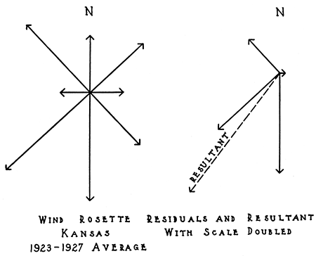
If the prevailing winds of to-day are similar to those of the past we have further evidence that the producing volcano or volcanoes must have been to the southwest. The accompanying sketch contains a wind rosette for the last five years, showing that the prevailing wind in Kansas today is from the southwest. This wind is most important during five months of the year. Other common winds are the northwest and south. If the wind residuals be plotted and the resultant. taken, as also shown on the sketch, it will be seen that the net effect of the wind in Kansas is to shift material to the northeast. However, this line of reasoning is open to objection, for the presence of a continental glacier to the north may have altered the prevailing wind direction in early Pleistocene times.
Figure 1
One would expect the variation in thickness of the deposits in a given direction to be a clue as to the direction from which the ash came. It was undoubtedly true immediately after the eruption that the ash decreased in thickness from the source outward. However, with the reworking of the ash this difference was largely obliterated, and the thicker ash deposits of to-day signify deeper depositories rather than closer proximity to the source. Of course there is a limit to this, for beyond a certain distance from the volcano there will be insufficient material to make an excessively deep deposit, regardless of the depth of the depression.
Ash deposits of early Plefstocene age must have come from a volcano which was in eruption during that period. In the intervening time between then and now a volcanic cone would suffer but little erosion. Such eroded plugs as the Spanish Peaks in Colorado and Mount Taylor in New Mexico are too old to be considered. But there are in New Mexico a number of volcanoes of post-Tertiary age. One of these or a group of these probably produced the volcanic ash of the Great Plains area.
The writer suggests the Capulin group of volcanoes, near the northeastern corner of New Mexico, as the most probable source for this ash. These volcanoes'" are post-Tertiary in age and lie to the southwest of the ash-covered area very near its point of convergence. [Note: Lee, 1912; Charles Keyes (Pan-American Geologist: 38, p. 413, 1922) has also suggested Mount Capulin as a possible source for the Great Plains ash, but he believes the volcano to he too recent. The writer admits that the last activity of this cone may have been very recent, but the ash was blown out during an earlier eruptive stage.] The principal volcano of the group is Mount Capulin, 6 miles south of the town of Folsom. This mountain rises about 1,500 feet above the plains and has a diameter at the base of 1 1/2 miles with a crater 1,500 feet in diameter and 75 to 275 feet deep. To the north and south of Capulin are a dozen or more similar cones which were eruptive during the same general period. This group most closely fits the conditions required of the volcanoes that produced the Pleistocene ash found in Kansas and adjacent states. [Note: For a more complete discussion of the source of the Pleistocene ash the reader is referred to a paper by the writer to be published in the Bulletin of the Geological Society of America.]
Next page--County Info and Technology
Kansas Geological Survey, Volcanic Ash Resources of Kansas
Placed on web July 7, 2015; originally published in April 15, 1928.
Comments to webadmin@kgs.ku.edu
The URL for this page is http://www.kgs.ku.edu/Publications/Bulletins/14/index.html