![]()
Prev Page--Camp Funston || Next Page--Appendix--Explanation of Maps
Chapter III—Features of Military Significance
The armies of the Great War know that the physical features of the country in which they fight affect almost their every activity. Each campaign demonstrates how large a role is played by the ground over which the armies move and fight. Military strategy is based on geography and topography as fundamentally as upon the fighting ability of armies. Mountains and rivers are barriers to the movement of armies; plains invite them forward. Steep slopes hinder or make impossible movements of artillery, cavalry, tanks, or infantry; gentle slopes are open to them. Defensive lines are placed where the advance of the enemy will be most difficult—along hills, high cliffs, swamps, large rivers, covers of forest. Offensive movements are directed toward country easy to traverse. Details of topography determine the landing places of aeroplanes, and control to a greater or less degree the effectiveness of gas warfare. Character of soils and underlying rocks determine whether trenches may be constructed quickly and maintained effectively. The study of these features broadly and in detail is absolutely essential to the proper direction of troops in the field and to a clear understanding of the movements of armies.
The following paragraphs present briefly points of military significance in the country around Camp Funston: first, those of a general nature affecting the strategy of a military campaign as a whole; second, features in the immediate vicinity of Camp Funston of importance in military tactics.
Problems of Military Strategy
Military strategy involves the conception, or plan, of army locations and movements in campaigns. It is based upon a broad knowledge of the nature of the country to be traversed by the armies in the field, the strength and disposition of the opposing forces, problems of food and munition supplies, transportation; and the condition of army morale. The violation of Belgium in August, 1914, due to "military necessity," was a part of the German strategy to avoid the difficult country west of Metz on the direct and short line to Paris. The rapid retreat of the Allies and the sudden furious stand against the Germans, which won the first great battle of the war at the Marne, was in accordance with the strategic plan of Joffre. Similarly, the invulnerable defense of Verdun, the battles of Flanders and Picardy, and in the summer of 1918 the swift blow of Foch at Soissons, which began the great German evacuation of northern France and Belgium, are parts of broad strategic plans. Military strategy is the guide which controls all the work of fighting forces in the field—the plan which chooses times and places for attacks, retreats, and for unyielding defense.
It will be observed at once that the relation of any specific area, such as that about Camp Funston, to the large problems of military strategy in a campaign depends wholly on where the armies are located and what the direction of their movements. The general terms of the problems—food supply, munitions production, transportation, and protection of natural resources—would vary materially in case the supposed enemy were advancing north, east, south or west across north central Kansas. Moreover, the great, open, central plain of the United States is so unlike the battle ground of western Europe that it is difficult to draw any parallel to the conditions of military strategy in the present war. Even the far-flung battle lines of the Union and Confederate forces of the Civil War may not be compared to those in the present conflict. Nevertheless, the distribution of fertile fields, the position of great manufacturing and munitions centers, the location of iron ore, coal and petroleum deposits, the number and directions of railroads and highways, and especially the general nature of the topography in the central United States, would play a prominent part in outlining the movements of an army across north central Kansas. Most of the materials needed for war are east of Camp Funston, and it would be advantageous to defend eastern Kansas, Oklahoma, the Mississippi valley and eastern states with their well-watered fields, great cities, many railroads, and immense natural resources of coal, iron and petroleum, against an enemy advancing from the west, while it would be difficult to make attack from the arid west across the mountains of Colorado. On the other hand, the character of the terrain in north central Kansas, with its east-facing escarpments, like those of northern France, would favor defense against an enemy approaching from the east.
Problems of Military Tactics
Military tactics has to do with the successful and effective carrying out of the details in a strategic plan. It controls in detail the positions and movements of troops in the field, the location of trenches, gun emplacements, camps and billets, construction of roads and railroads for transport, and the choice of immediate objectives in attack. It touches every phase of the everyday work of an army in the field and depends upon features with which every soldier and officer should be familiar. From the standpoint of military tactics, there are many features in the region about Camp Funston which may be of very practical value in the training of the soldier, and they are of added interest at this time because in so many ways they duplicate conditions to be found in northern France, Belgium and western Germany. These features will be discussed briefly under their appropriate headings.
Barriers
The ease or difficulty with which country can be traversed by troops in the field—infantry; cavalry, artillery, tanks and transports—governs to a very large degree the nature of military operations.
In a flat plain, like Flanders and northern Belgium, movements may be executed with utmost ease except when prolonged wet weather makes the plain a morass. The same may be said for river plains like the Aisne, the Somme, or the Kansas, except for crossing the rivers themselves or in time of floods. In Flanders defenses are located with reference to any natural barriers available—rivers, canals, and low hills; or artificial barriers are constructed—barbed-wire entanglements, trench systems, and other fortifications. In such country even low ridges (Messines ridge, Mont Kemmel, Paschendaele ridge) become of greatest possible tactical importance because they dominate the surrounding lowlands. Some of the bitterest fighting of the war has been waged for their possession.
In hilly country, even a plains region with moderate relief, like Kansas or a large portion of northern France, any dominating feature of the topography assumes great tactical importance. The series of ridges and east-facing escarpments which form the natural defenses of Paris (Chapter I) have been in every campaign the keys to success for the opposing forces. The escarpment at Verdun is the barrier at which the German crown prince lost half a million of his best troops in unavailing efforts to capture "the gateway to. Paris." The long, narrow ridge east of Soissons, along which runs the famous Chemin des Dames, is the barrier which dominates the valleys of the Aillette and the Aisne, and the lowland country toward Laon. It has been the ground fought over in the terrific Champagne battles. The larger streams are also important military barriers, not only because of the difficulty in crossing them under normal conditions, but because under fire of an enemy intrenched on the bluffs beyond it becomes an exceedingly serious problem to effect a crossing in force. Artillery must be brought up to silence as far as possible the hostile fire, bridgeheads must be established, and the crossing is at best a very difficult and dangerous manoeuver. The Austrians were thus delayed in their early attempts to cross the Save and the Danube into Serbia. After the strategic retreat of Joffre and the defeat of the Germans at the Marne in 1914 the Allies pursued the invaders to the Aisne; but all attempts to effect a crossing of this barrier failed. Similarly, the Italians were able to defend the barrier of the Piave river after Cadorna's disaster before Trieste, and in the Austrian offensive of the spring of 1918 to capture thousands of the enemy troops caught behind the flooded and impassable river. Forests have served in the same way to block the advance of armies, both because they are easily made more impassable by means of wire entanglements and because they screen the movements of troops. The bitter fighting of the Americans for the Bois de Belleau (renamed Bois des Americains) and in the Argonne forest, and the long time required to expel the Germans from St. Gobain forest near Laon, the bulwark of the Hindenburg line, sufficiently show the part played by forest barriers. Swamps and lakes are barriers which proved the ruin of the great Russian offensive in east Prussia when Hindenburg brought disaster to the invading Russian armies. The marsh of St, Gond was a decisive factor in the victory at the first Battle of the Marne. In short, any feature of the terrain which makes the movements of an army difficult—in other words, a barrier—is an important object of study in military tactics.
In the vicinity of Camp Funston there are a number of military barriers. The topography of north central Kansas is quite like that of a large portion of the European battle area, and there is opportunity for much valuable topographic study. The chief natural barriers are (1) the large streams, and (2) steep slopes, including (a) the river bluffs and (b) the upland ravines.
Kansas river and its two main tributaries, Republican and Smoky Hill rivers, are all sufficiently large to impede seriously the crossing of men, artillery, tanks and motor transports, except where they are bridged. Republican river is crossed near its junction with the Smoky Hili at the head of the Kansas by bridges of the Union Pacific, the interurban; and a road bridge, and again by the Golden Belt highway just north of Junction City. These passageways connecting Camp Funston arid Junction City are the only crossings of the Republican and Kansas riverS between Manhattan, eighteen miles northeast of Junction City, and the small town of Milford, twelve miles northwest, or a total distance, as the river flows, of forty-four miles. The wide separation of the bridges along the Kansas and Republican leaves very long stretches which are without practicable crossings. Bridges are easily destroyed, so that the problem of stream crossing here under conditions of actual warfare would be a serious one. The river would become an almost impassable barrier in floods. There are four bridges across Smoky Hill river within six miles south of Junction City. The problem here, especially as the Smoky Hill can at certain places be forded in low water, is not so serious, but farther west there is a considerable stretch without bridges.
The high river bluffs which line either side of the Kansas, Republican and Smoky Hill are of very great military importance, commanding all they do the bottom lands for many miles up and down the river. Forces strongly intrenched along the bluffs, with guns properly emplaced, would make attempts by a hostile force to cross the stream and climb the bluffs to attack extremely hazardous. In defending the line of bluffs it would be necessary to give special attention to the gaps where tributary streams, such as Three Mile creek, flow down from the upland. The continuity of defending trenches on the higher land is broken here, and this is the easiest point of attack for enemy troops. The Germans advancing west from Metz in 1914 were unable to take the line of bluffs east of Verdun; but ascending breaks in the bluffs caused by east-flowing streams, they were able to capture St. Mihiel. This they held uninterruptedly until Pershing's attack in 1918 obliterated the threatening salient. Similarly, the importance of Rheims, Laon and Toul are largely due to the positions which they occupy at the breaks in escarpments.
The country back of the bluffs, due to its extreme roughness, is difficult both for defending and attacking troops. The relations of slopes of various angles in the stream valleys of this portion of the reservation to movements of infantry, cavalry, tanks and artillery, and to protection against fire from various positions on the uplands, is of some little interest. Problems of trench location with reference to the defense of the uplands may be studied to advantage.
The east-facing escarpments produced by the outcrops of hard limestone beds are the most-important military barriers in the country back from the large streams. (Fig. 17.) From the top of the escarpment the region below may. be observed clearly for many miles, and it could be dominated easily by gun fire. The Camp Funston region is at the north end of one of the most prominent escarpment lines in Kansas, that of the so-called "Flint Hills." To the south. of Funston it is higher and less broken by stream valleys, and it forms here a barrier in almost every respect a counterpart of the defenses of Paris. There are excellent opportunities along the escarpments near Camp Funston for study of military tactics with reference to this type of barrier.
Roads
Of very first importance to an army is the position, number and character of all means of transportation, railroads, roads, harbors, rivers, and canals. Like all armies, the modern army "travels on its stomach," and, to a degree hitherto undreamed of, depends on an uninterrupted supply, of the materials with which it wages war. Without food and ammunition and without means for bringing reserves when needed an army is helpless. One of the foremost considerations of an army commander, therefore, is to provide and protect adequate means of communication between his armies and bases of supplies. The shorter and easier the conditions of transport for men, food and munitions, the greater the advantage, and conversely. The British disaster at Kut-el-Amara, Mesopotamia, in 1915, was due to overlong lines of communication and their inadequate protection. The rapid retreat of the Germans from the Marne in July, 1918, was caused by the threat to the German lines of communication from the successful Franco-American attack on their flank at Soissons. The short distance of the German supply centers from both eastern and western fronts in the first years of the war made it possible for them to supply easily the armies in the field and to shift reserves quickly from one front to another. Germany was on the inside of a circle, with excellent means of transportation, the Allies on the outside, with means of intercommunication very difficult. The same advantage of transportation conditions has been with the Germans on the Western Front, where, until Foch begun to press the enemy on all sectors of the line, it was possible to shift reserves and materials from one part of outward bent line to another. The selection of important lines of defenses, as the Hindenburg line, the Valenciennes-Mézières-Metz line, has been made in no small part with reference to lines of easy communication parallel to the front and back of the German lines. The remarkable system of roads in France has been of almost incalculable service to the Allies, and since the beginning of the war many new roads and railroads have been constructed. One of the first calls on America's entrance into the war was for regiments of railroad and highway engineers.
Near Camp Funston the main avenue of transportation is the big valley of the Kansas river. Here lies the main line of an important transcontinental railroad, and electric interurban, and excellent automobile highways. A short distance west of Camp Funston, between Salina and Abilene, the Smoky Hill valley is occupied by three independent railroads. The Golden Belt highway, from Kansas City and Topeka to Denver, is surfaced with limestone in the vicinity of Camp Funston and is an excellent road even in wet weather. The electric interurban runs only from Manhattan to Junction City. Communication in an east-and-west direction is very easy. Transportation either north or south across the upland, however, is more difficult. There are no railroads except the line of the M. K. & T. railway south from Junction City, and branches of the Union Pacific in the valleys of Republican river to the northwest and Blue river at Manhattan, north. Wagon roads to the north and south are of the ordinary "dirt" type. Main roads are very good in dry weather, but are almost impassable after protracted rains. There is abundant material of very satisfactory character for road surfacing in the vicinity of the camp, in the hard limestone and flint beds which are exposed along the bluffs and in the stream valleys of the uplands. Quarries have been opened at a number of points near Fort Riley and Camp Funston and road work has been active. Streets in the camp, at Fort Riley, and a number of the roads in the reservation are now surfaced, all-weather roads. In general, however, the roads of north central Kansas have not been improved. For economic reasons, if not for military purposes, it is strongly to be hoped that highway construction and improvement may be undertaken vigorously.
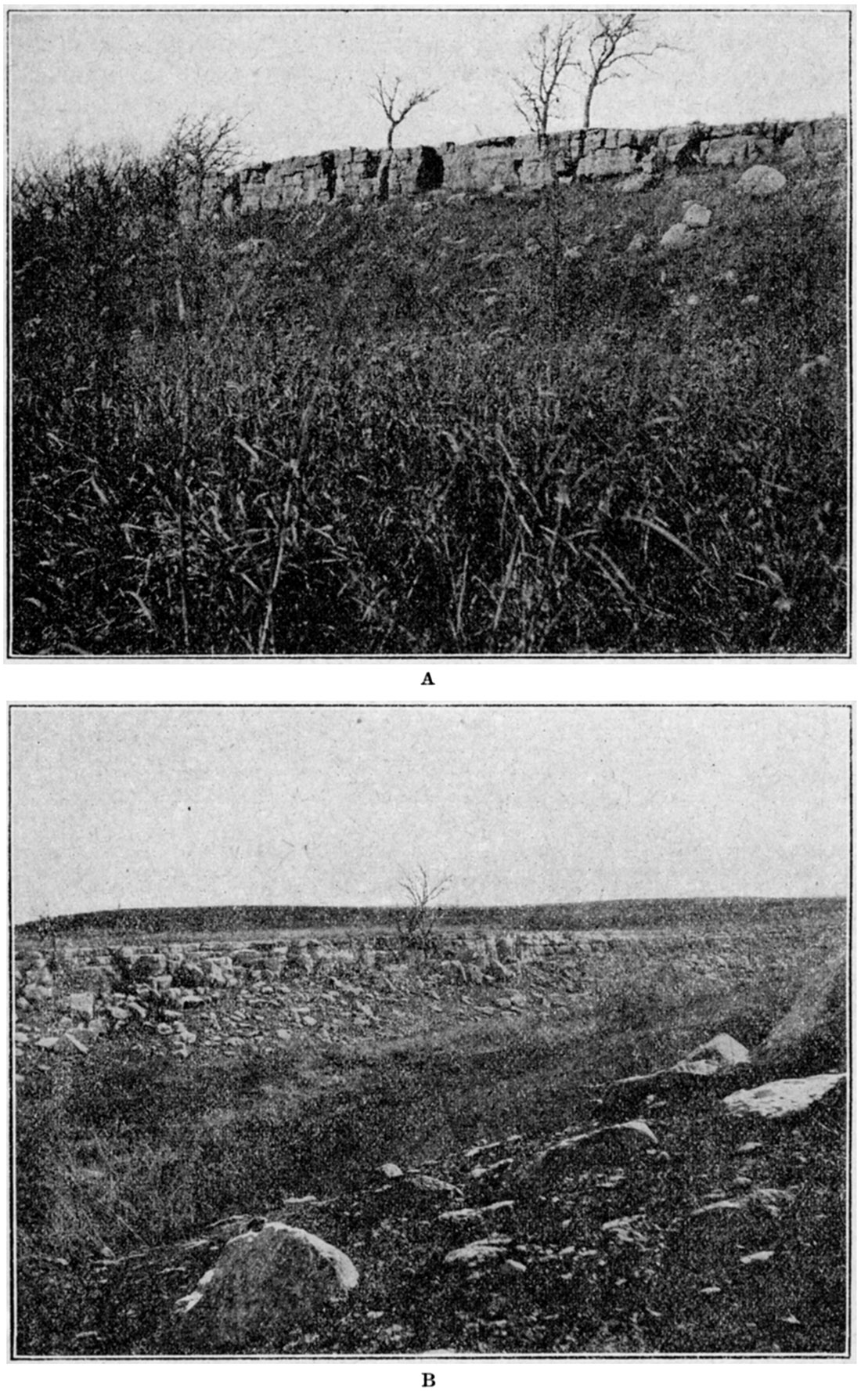
Figure 31—Diagram showing typical relation of soil to underlying rocks. In many places soil is extremely thin, and if the rock beneath is a hard formation, trench construction is slow and difficult.
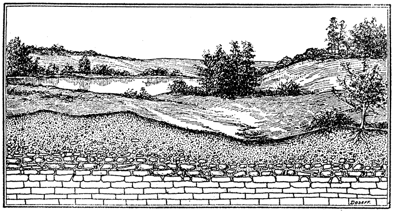
Plate XI—A. Exposure of Fort Riley limestone at top of valley slope. Uplands northwest of Camp Funston. B. Wall of Fort Riley limestone and broken fragments from its weathering, near head of Forsythe creek.
Trenching and Tunneling
The present conflict has developed, to a degree previously unknown in warfare, the art of temporary and permanent defense systems of trenches, tunnels and dugouts. Some of the trenches of the opposing forces on the Western Front, especially those of the Hindenburg line and supporting defenses, are exceedingly elaborate works. All soldiers in active service are equipped with trenching tools for use either in constructing temporary individual "funk" holes or in excavating complete trench systems. The nature of the ground in which ditches or trenches are to be excavated is of prime interest and importance to any body of troops in the field. Successful operations in actual warfare often depend upon the quickness with which trench protection can be constructed and the effectiveness with which it can be defended.
The thickness and constitution of the soil, the nature of the underlying rocks, and the problem of drainage are all features which should enter into the selection of trench locations, particularly of those which are to serve as more or less permanent lines of defense. In a soft, loamy soil with underlying shale formation, as on the upland in the northwest part of the reservation, trenches may be constructed quickly and easily. However, on many of the lower divides and on steep slopes where the bedrock is near the surface, limestone beds will probably be encountered in trenching operations. Where the limestone has been broken into small pieces by freezing and thawing, and disintegrated by the dissolving action of rain water—in other words, where the rock is much weathered—it may be possible to construct trenches to depths necessary without great difficulty. Where hard rock is close to the surface and relatively unweathered it is, of course, very difficult to excavate a trench, and in a thin-soiled region of hard rocks, like granite, for example, it is almost impossible to construct trenches without blasting.
The problem of drainage in trenches is a very important one and deserves careful study. Facility of drainage depends upon the topographic position of the trench system and upon the material in which the trench is excavated, It is impossible to drain a trench in a water-soaked lowland, such as a river plain during wet season, and on some river plains trenches would be more or less filled with water most of the year. In case of flood, trenches on river flats would, of course, become absolutely untenable. Much of the discomfort and danger of river-plain trenches have been experienced by the troops in the low wet plains of Flanders. It is impossible to construct dugouts in a water-soaked plain. Trenches in higher ground may be drained (1) by making the bottoms of the trenches slope enough for the water to run out, (2) by digging ditches near the trenches so as to divert surface drainage from them, and (3) in some cases by underdraining through a boring into a porous lower stratum. Rocky or sandy material is, in general, sufficiently porous to drain readily without much trouble. Trenches constructed in areas of dune sand, such as on the coast of northern France, therefore, are generally dry even in wet weather. Trenches in clayey material tend to hold their moisture and drainage is difficult.
The walls of trenches in rock will stand without support, but in ordinary soil, sand or clay, revetment of some sort is needed if the trenches are to be more than temporary. This is illustrated by the slumping in of some of the trenches constructed near Camp Funston a year ago. Method of revetment depends upon the nature of the material in which the trenches are excavated.
Tunneling has been important in the battle fields of Europe both for offensive and defensive purposes; in offense for mine-laying and listening operations, in defense for dugout and bombproof shelter construction. As in trenching, the problem of tunneling depends very greatly upon the nature of the material to be penetrated. Tunneling in a hard, massive, rock formation is a slow, difficult process, but underground rooms constructed in solid rock are thoroughly bombproof and of permanent value.
In the uplands behind Camp Funston conditions are excellent for practice tunneling, Tunnels and dugouts may be excavated very quickly in the shale formations here, and if they are located just below the limestone beds the limestone will form a natural strong roof. The roof of any large tunnel or room underground should, however, be adequately supported by strong pillars. At some places on the western front and in Italy natural underground passageways, made by the action of ground water, like Mammoth cave and the many caverns of Kentucky, Virginia, Missouri and other states, have been used very effectively by both fighting forces. Great underground rooms (dolines), some of them large enough to, hold whole battalions and great quantities of supplies, were employed by the Austrians defending Trieste as shelters for troops, gun emplacements and as natural fortresses. The Italians found it almost impossible to dislodge their opponents from these natural strongholds. Underground tunnels and caves in the thick limestone bluffs around Verdun were similarly utilized by the French for the protection of their troops and as emplacements for their guns, contributing in no small degree to the decisive defeat of the German assaults. Very successfully and systematically the Germans have employed trained geologic engineers for advice as to location of trenches, tunnels and other excavations. Taking into account ease of excavation, possibilities of drainage, and the ability of materials to stand both when wet and dry, their assistance in this sort of engineering work, as well as in road construction, water supply and many other problems of an army in the field, has been invaluable.
Water Supply
The problem of water supply is a fundamental one to an army. More than one military campaign in the past has proved costly or disastrous because of failure to recognize adequately the fact. In a well-watered region with heavy rainfall there may be springs with large flow, but this rarely affords a sufficient supply for a large number of men. The most important problems of water supply are, first, to obtain pure water; secondly, to obtain it in sufficient quantities at the places where it is needed.
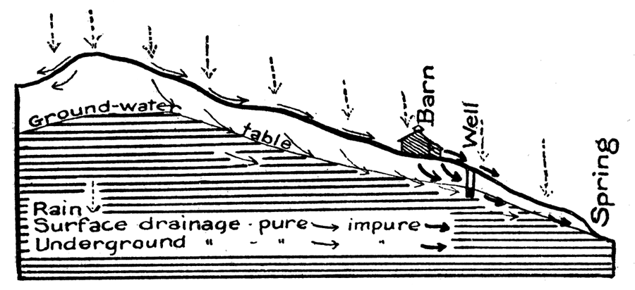
Since the water in streams is generally entirely unsuitable for drinking, and especially. so under war conditions, chief dependence must be placed in wells. Well water is rain water which has entered the ground, in some cases having moved long distances from its place of entrance before reaching a well, in others only a short distance, The purity of well water depends wholly on the sources of the water and the cleanness of the well. The possibilities of well contamination, therefore, should be thoroughly understood, Underground water moves down slopes just as surface water does. If a stable or other source of contamination is located near and above a well (Fig. 33), not only may surface drainage from it reach the well, but impurities will be carried by the water sinking into the ground and will find their way into the well, unless the well is specially constructed so as to exclude it. Modern drilled wells are generally cased to a point some distance below the ground-water level, which stops the entrance of contaminating surface and near surface drainage. The water in such well is very much safer than in the old-fashioned "dug" well, open at the top and uncased. In every case a well should be located so as to avoid as much as possible any likely source of contamination. In regions of dense population, as in villages and cities, or even in thickly settled farming communities, shallow wells are very unsafe unless properly located and constructed. In the present war, according to press dispatches, difficulty in securing pure water has been aggravated in certain places on account of intentional contamination and poisoning of well waters by the enemy.
In many places to obtain drinking water in sufficient quantities for a large number of men is a serious problem. The largest and most permanent sources are the underflow of large streams, such as the Kansas, the water of certain porous underground strata, and bodies of surface water, such as lakes, which are sufficiently large and pure. In moist climates all of these sources are likely to be larger than in dry regions. Geologic information is always desirable in seeking supplies of drinking water for military camps.
Figure 32—Section of water well on the Kansas river plain, one of eight which supply Camp Funston. The water, obtained in coarse sand and gravel, is part of the underflow of Kansas river.
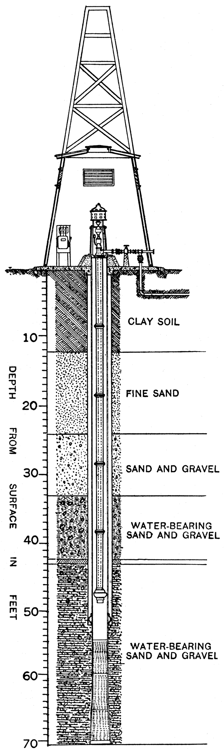
The water supply of Camp Funston is obtained from eight wells drilled on the flood plain of Kansas river at the south and west edges of the camp. The first wells, drilled during the early construction of the camp, are located south of the camp near the river, and are relatively shallow (40 to 58 feet). Their individual capacities range from 115 to 315 gallons per minute, their combined capacity being about 940 gallons per minute. In November, 1917, three wells were drilled on the west side of the camp to a depth of about 71 feet, penetrating. in their lower portion (Fig. 32) thick deposits of coarse water-bearing sand and gravel, the water being part of the underflow of Kansas river. The capacities of these wells—875, 1,100, and 1,200 gallons per minute—is very much larger than any of the shallow wells, and the total available daily water supply for the camp (approximately 4,320,000 gallons per day of 24 hours) is entirely adequate for the requirements of the camp. [Note: Information concerning the water supply of Camp Funston was kindly furnished by Major W. L. Benham, officer in charge of camp utilities.]
Figure 33—Diagram showing relation of ground-water table to the surface, and sources of possible well and spring contamination. Surface drainage and underground seepage from barn may enter well or spring below.
The water is pumped from the wells to a collecting reservoir, and from this reservoir is lifted to four wooden tanks of 200,000 gallons capacity each, located on the bluffs north of the camp.
The water from the wells is extremely hard, containing approximately 6 grains of solid matter per gallon, or about 400 parts per million. On account of the deposits of iron and other solids and the growth of Crenothrix, a low form of plant life, with consequent damage to water tanks, boilers and water backs, a new 3,000,000-gallon per day iron-removal reservoir and rapid sand mechanical filter plant is being constructed. The water will also be softened by a soda and lime treatment, which will remove all encrustating solids.
The water supply of Fort Riley is obtained from wells located about a mile west of the fort on the flood plain of Republican river. The water is pumped to the large reservoir on the hill behind the fort by the pumping station in Pumphouse canyon.
Prev Page--Camp Funston || Next Page--Appendix--Explanation of Maps
Kansas Geological Survey, Geology
Placed on web Feb. 12, 2018; originally published 1918.
Comments to webadmin@kgs.ku.edu
The URL for this page is http://www.kgs.ku.edu/Publications/Bulletins/4/04_significance.html