![]()
Prev Page--Western Theater || Next Page--Military Significance
Chapter II—The Region about Camp Funston
Camp Funston is located almost at the exact geographic center of the United States. Indeed this median point is said to fall within the Fort Riley military reservation about four miles southwest of Camp Funston, where it is marked by a monument erected to Major E. A. Logan, who first located the present fort and called it Camp Center, "it being very near the geographical center of the United States." [Circular issued by the United States Surgeon General's office, 1875, cited by Blackmar, Frank W., Kansas, A Cyclopedia of State History, vol. I, pp. 668, 671; 1912.] The camp is in the midst of a great prairie country which slopes gently eastward from the Front Range of the Rocky Mountains to the Mississippi, reaching north into Canada and south to the Gulf of Mexico. The region is well named the Great Plains, for there are few places in the world where so vast an expanse of unbroken plains country may be found. The west portion of the plains, from the Rockies east to western Kansas and Nebraska, is remarkably featureless, in places absolutely flat so far as the eye can determine. This belt, often spoken of as the High Plains, gets relatively little rainfall because of its position in the lee of the high mountains, and it is not thickly settled. The east portion of the Great Plains is marked by a succession of low east-facing escarpments or steps, readily traceable for long distances from north to south: These Scarped Plains, as they are called, are better watered, and therefore much more thickly settled, than the High Plains farther west.
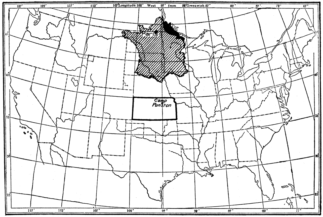
Figure 10—Map showing location of Camp Funston and relation in latitude to France. The battle area of northern France is nearly 700 miles farther north than Camp Funston. This map also shows relative size of Kansas and France.
Camp Funston is in the west portion of the Scarped Plains, where the country, while broadly a plain, is yet marked by hills and escarpments which rise more than 300 feet above the level of the valley bottoms. It is situated on Kansas river, about 140 miles west of Kansas City, and nearly midway between Manhattan, at the mouth of Blue river, and Junction City, where Smoky Hill and Republican rivers unite to form the Kansas. Like the original Fort Riley, the camp is in an important strategic position, controlling as it does the main lines of easy passage along the river plain to the east, southwest and northwest. In early days Fort Riley was a strong frontier post in the warfare with the Indians.
In the landscape about Camp Funston the features of primary interest to the soldier are (1) the bottom lands of the large streams, (2) the bluffs which border the river plains, and (3) the rolling upland, deeply cut by the ravines tributary to the main river valleys. These portions of the landscape may be considered briefly in turn.
Bottom Lands
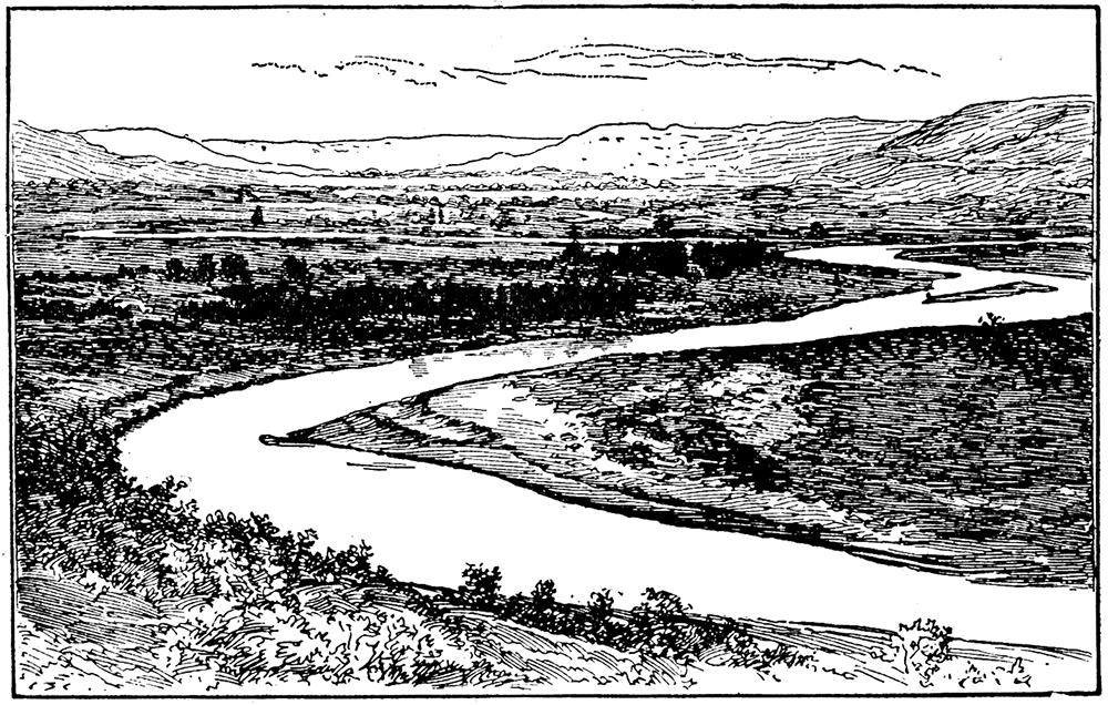
The camp is built entirely on the broad bottom land of Kansas river in the east part of the Fort Riley military reservation. The view of the camp and bottom land from almost any point on the high bluffs at either side of the river is most interesting and shows to advantage the peculiar characters of the river land. The bottoms appear perfectly flat, as indicated in the names Smoky Hill flats and Republican flats, and they extend without break, except where the winding river has cut its channel, from bluff to bluff and as far up and down the river as the eye can reach. [Note: This Is shown on the, map, Plate I, by the very wide spacing of contours. See Appendix.] The bottom lands are really a long narrow plain which stretches like a ribbon along the general course of the river, including within its limits all the curves and irregularities of the river. It extends eastward, very sharply defined and without interruption, as far as Kansas City, where it joins the similar river plain of Missouri river. It is itself joined by many smaller river plains, where tributary streams flow into the Kansas. Such are the mile-wide bottom lands of Big Blue river which extend for many miles north of Manhattan, the plain of Vermillion river east of Manhattan, and, on the Fort Riley military reservation, the bottom lands of Three Mile and Forsythe creeks. West of Camp Funston the plain of the Kansas divides at Junction City, one branch going to the northwest with Republican river, the other to the southwest and west with Smoky Hill river. Perhaps the river plain of the Kansas should be said to end opposite Fort Riley, since by a geographic freak the name Kansas river is applied only to the waters below the confluence of the Republican and Smoky Hill; but the plains are continuous each with the other. The plains of Three Mile and Forsythe creeks, the only streams in the military reservation having well-developed bottom lands, reach back about three and two miles, respectively, from the edge of the Kansas river plain.
Figure 11—Profile across the Kansas river valley at Pawnee Point, showing flood plain and bluffs. Elevation above sea level is shown at the left.
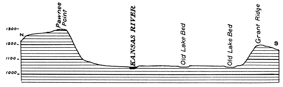
Figure 12—Profile across the Kansas river valley at Fort Riley, showing the flood plain of the river (Smoky Hill flats), the bench on which Fort Riley is situated, and the bluffs to the north and south.
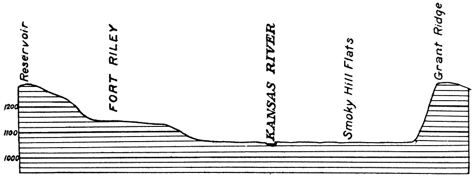
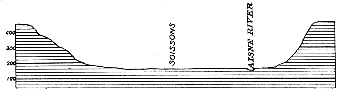
Figure 13—Profile across the Aisne river valley at Soissons, showing flood plain of the river and bluffs. Comparison with Figures 11 and 12 shows the similarity of the Aisne valley to that of the Kansas. The same is true for other French rivers.
The width of the Kansas bottom lands is rather uniformly about two miles, but at some points, as near Junction City, they are nearly three miles wide, while at others, as at Manhattan, they are hardly a mile across. The plains of the tributary streams are much narrower than that of the Kansas. The flats of Three Mile and Forsythe creeks are but a quarter of a mile wide, and those in Pumphouse canyon and along Four Mile creek, west of Fort Riley, have a width of less than 100 yards. Big Blue river north of Manhattan has a plain a mile to a mile and a half wide.
River plains appear to be about the same height everywhere above the water in the streams which flow through them, and since streams have an inclination in the direction of their flow, it follows that the bottom lands must also slope in the same direction. This is proven by measurements of the elevation above sea level of points along the plain, as in the case of the Kansas plain, Lawrence 828 feet, Topeka 880 feet, Manhattan 1,012 feet, and Junction City 1,078 feet. [Gannett, Henry, A., Gazetteer of Kansas, U. S. Geological Survey, Bull. 154, 1898, available online.]
Figure 14—Meandering stream with wide flood plain and high bordering bluffs, showing topography typical of many of the rivers of France.
So intimate are the relations of the valley and plain of a river to the river that it is clear they have been formed by the river, and this is true for the Kansas and its tributaries. The carving of the Kansas valley has been going on for thousands of years, the stream having cut downward as much as the very slight slope to the Mississippi and Gulf permits (1,050 feet in 1,200 miles, i. e. about 1.14 feet per mile), and sideward against either bluff to the bounds of the river's swinging curves. Downward cutting has virtually ceased, but erosion sideward is still active wherever the river turns to the side of its valley. The smooth, slightly curved outline of the bluffs at Sherman Heights, north of Junction City, of Grant Ridge, opposite Fort Riley, and the bluff northeast of the cavalry camp are the marks of recent side cutting by the river. The projecting rock ledge on which Fort Riley stands is being attacked now where the river swings against it on the southwest. Forsythe creek is very actively widening its valley, cutting here on one side, there on the opposite side of its flat. (See map, Plate VI.)
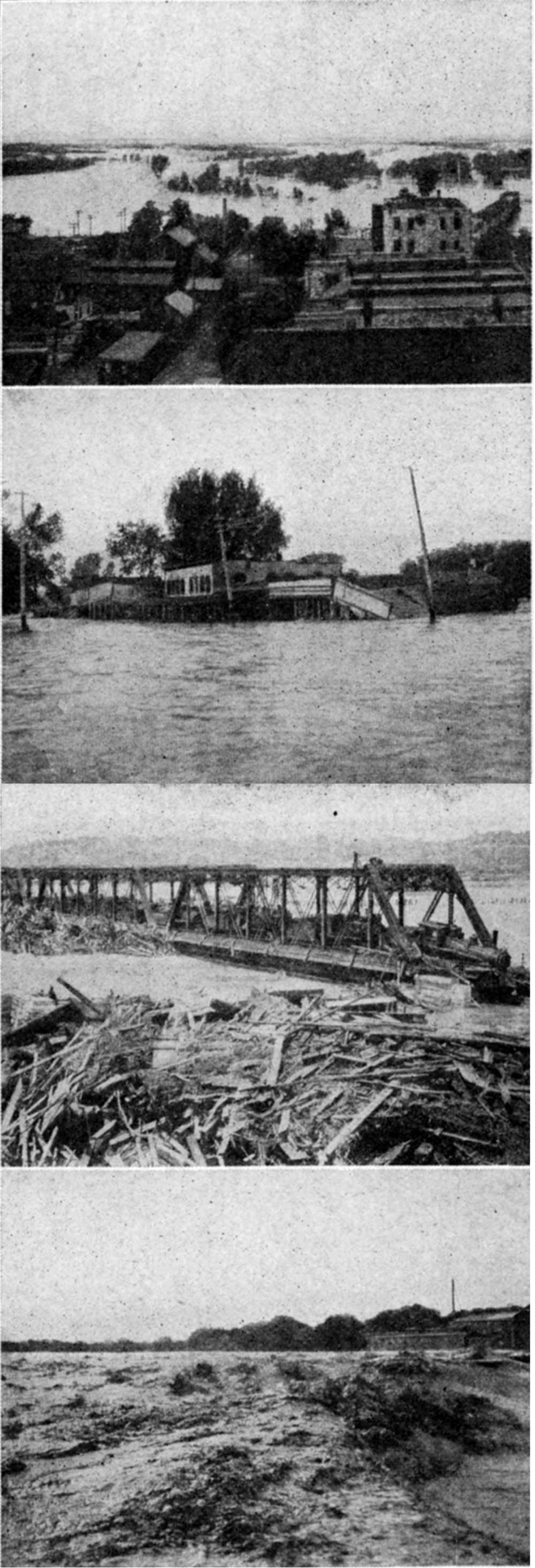
Plate II—Kansas river in flood, 1908.
There is a constant small, almost indeterminable shifting of the channel of a stream on its plain, which results in more or less regular swinging curves, called meanders. Such meanders are well shown in the course of the Kansas near Camp Funston, but are even more evident in the Smoky Hill south of Junction City. (Plate X.) They are characteristic of most of the rivers of France. Occasionally the opposite sides of a swinging curve come together, and a more or less pronounced change in the course of the stream results. The abandoned portion of the river's channel forms a horseshoe-shaped lake, but eventually it is filled up with mud and plant growth. Thus Whiskey lake, east of Fort Riley, represents a former position of the Kansas river channel when it cut against Grant ridge. This old course was abandoned when one side of the bend cut into the opposite side in front of the fort. Most of the old river meander is filled up, which accounts for the present small size of Whiskey lake. A slight amount of erosion by the current of Smoky Hill river as it swings against its north bank near the junction with the Republican would shift the mouth; of the Smoky Hill to a point due south of Fort Riley more than a mile east of the present confluence. To prevent this the bank of the Smoky Hill has been heavily reinforced with stone revetment. It has been necessary to protect in a similar fashion the river bank at the east edge of Camp Funston.
River plains are always subject to overflow by the rivers in time of flood, and on this account they are often called flood plains. Floods leave a deposit of fine, extremely fertile alluvium over the plain, and thus add to the richness of the land, but in general they do much more harm than good. Not only may unharvested crops on the river flat be ruined during flood, but almost everything in the path of the water may be destroyed or washed away, for the erosive power of a stream in flood is many times greater than under ordinary conditions. Bridges, roads, railroads, houses and towns may be severely damaged, and in not a few cases thousands of human lives lost. Therefore, unless provision is made to protect the works and habitations of man by the selection for them of suitable sites, by well-chosen methods of construction, or by systems of flood control, danger may be anticipated at some time from flood. In some streams floods are of much greater frequency than in others, a fact depending on a number of factors. Kansas river is subject to partial flooding almost annually (Fig. 15), but bad floods are of rather infrequent occurrence, the last important ones having occurred in 1903 and 1904. In the flood of 1903 much damage was done to roads, railroads and towns along the river. Crops were ruined and traffic was impossible for days. Camp Funston is leis favorably situated than Fort Riley with respect to danger from floods, for the fort is on a projecting bench, fully thirty feet above the flood plain of the river (Fig. 12), while the camp is on the flood plain itself. This means that any protracted spell of wet weather makes the land around the camp very muddy and necessitates elaborate arrangements for drainage. No flood has occurred since the organization of Camp Funston.
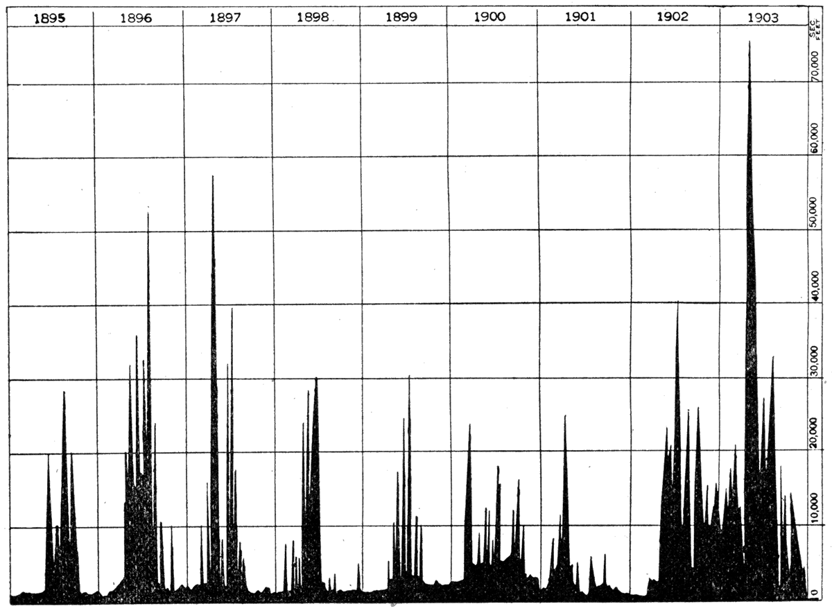
Figure 15—Chart showing yearly high water and flood stages in Kansas river at Lawrence, 1895-1903. Note that time of high water is chiefly in the summer months, and that it occurs somewhat regularly. The high peak in 1903 marks the great flood of that year.
River plains are of great value to man because of their fertility and because they constitute easy and natural routes for travel. Not only is the alluvial soil of the river plain richer than ordinary soil, but the land is flat, and there is a never-failing water supply at hand. Consequently some of the most intensively cultivated areas of the globe are the flood plains of large streams, as, for example, the Nile, the Ganges and the Hoangho. The river plains of the Kansas and its tributaries are intensively farmed above and below Camp Funston, but in the military reservetion the flats are used only for rifle ranges, polo grounds and manoeuvers, a considerable area near Fort Riley being left with forest cover. The river bottom north and northwest of Junction City is very sandy and contains many low mounds of wind-blown sand, which may correctly be regarded as dunes. Most of these are now covered with vegetation, which holds them stationary. Such sandy areas are of course, not so well adapted for farming.
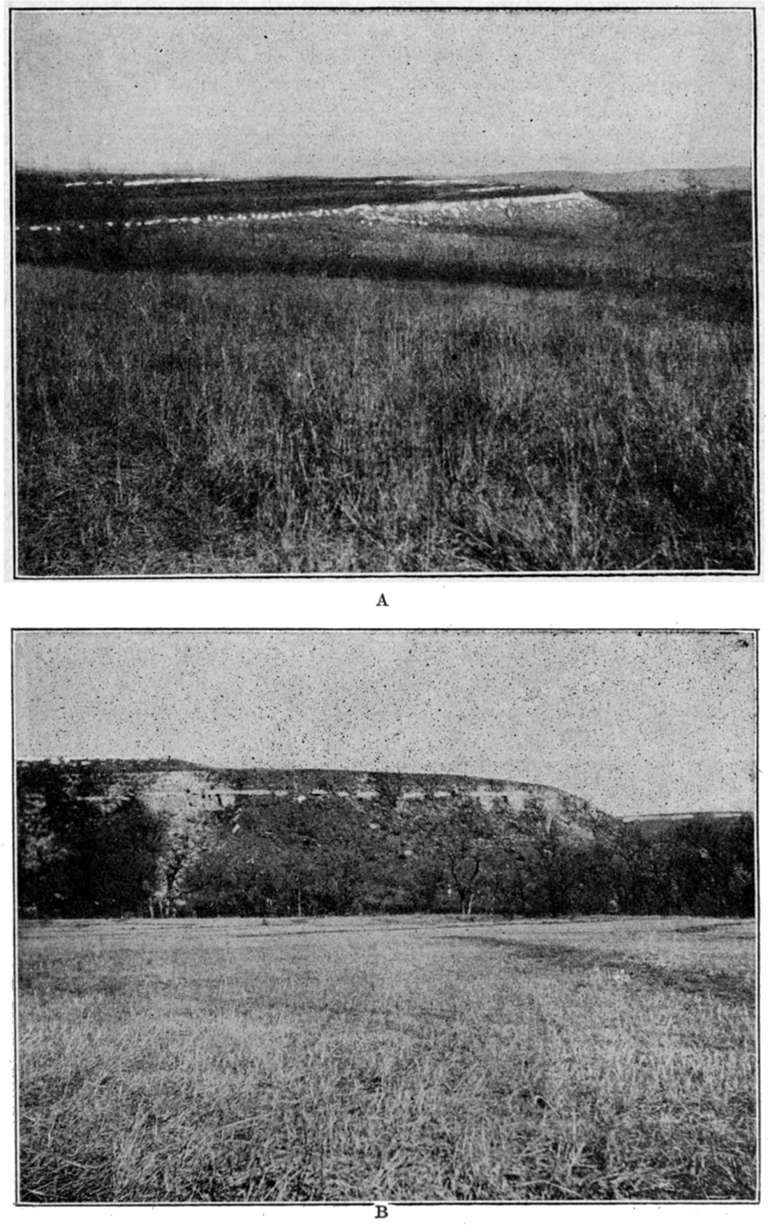
Plate III—A. Escarpments of Fort Riley limestone overlooking Kansas river near Fort Riley. B. River bluffs near Four Mile creek, showing flat bottom and and upland limestone benches.
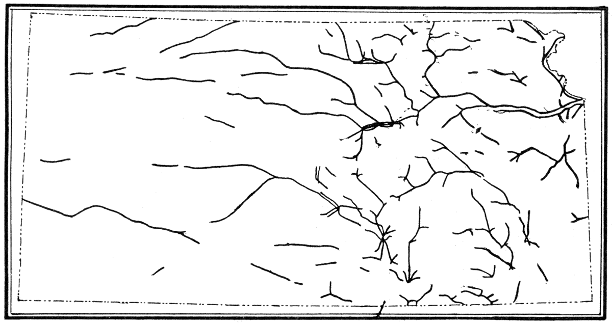
In mountainous or roughly hilly country stream valleys afford the only practicable means of transportation, and along them lie the main roads and railroads, villages and towns. The same is true to an important degree in a plains region of moderate relief, like north central Kansas, as may be seen by reference to Figure 16, showing the portions of railroad lines in Kansas which are laid in stream valleys. In the vicinity of Camp Funston the bottom lands of Kansas river and of its two branches to the west, the Republican and Smoky Hill, are the chief arteries of travel. The valley of the Kansas is occupied near the military reservation by the main line of the Union Pacific railroad, an electric interurban line which runs from Junction City to Manhattan, and important wagon and automobile. roads, including a county road on the south and the Golden Belt highway, a portion of one of the main transcontinental trails, on the north. At Junction City the Union Pacific divides, the main line proceeding up the valley of Smoky Hill river and a branch following the plain of the Republican to the northwest. The important strategic position of Camp Funston, Fort Riley and Junction City, at the intersection of the natural river-plain highways leading east, northwest, southwest and west, is therefore evident.
Figure 16—Map showing the railroads in Kansas which are laid in river valleys. River valleys are natural highways, which even in plains country like Kansas control largely the position of railroads and the location of cities.
River Bluffs
Rising steeply, almost precipitously, on both sides of the bottom lands of the Kansas and its two main tributaries, are lines of bluffs, straight or slightly curved, which mark the edge of the upland plains. These bluffs are much the most imposing feature of the topography to a traveler coming into the region. In places, as along (1) Grant ridge, south of Smoky Hill flats, (2) Macomb hill, west of Fort Riley and north of Republican river, (3) between Pawnee and Sheridan points, and (4) Summit hill, just back of Camp Funston, the bluffs, 150 to 200 feet high, present a nearly unbroken front to the river. In other places the bordering bluffs are breached by the entrances of the small streams which are tributaries to the main rivers. With the exception of the gap at Three Mile creek, however, most of the valleys cut into the bluffs are very narrow, so that the border line between the uplands and the bottom lands of the river appears very sharp indeed. This is very clearly shown on the large map of the military reservation (Plate I).
[Note: On the map steep slopes are represented by crowded contours. Where two contours are close together the steep slope is at least 20 feet high, the vertical distance between the contours, or contour interval, being 20 feet. Where a number of contours are close together, as along the edges of the river plain, the slope is higher, 20 feet for each space between the contour lines. Thus Pawnee Point, above the cavalry camp, between Camp Funston and Fort Riley, is shown to be 200 feet high.]The bluffs which confine the river flats and mark out the path of the roads and railroads, with their busy traffic, are a most difficult obstacle to travel in a direction across them. Thus, while a heavily loaded motor lorry proceeding along the river road below the bluffs would find easy progress everywhere, one crossing, from the upland south of the river to north of the military reservation would have to descend the bluffs south of the river, cross the river, and climb the bluffs on the north, The only possible way to accomplish the task would be to find a road leading down some tributary stream to the level of the river fiat, cross the river at a bridge, and ascend to the north upland by means of a road through one of the gaps in the bluffs, as at Three Mile creek or Magazine canyon. There are excellent roads along the river plain, but, excepting that at Junction City, almost none across the Kansas valley, due both to the steepness of the bluffs on either side and to the absence of bridges. A river valley with steep bluffs and a wide, deep river is a most troublesome barrier to travel, and it becomes an almost insurmountable obstacle in time of heavy flood.
Uplands
Above the bluffs and back from the river the country is very different, indeed, from the flat plain on which Camp Funston is situated. It is a region of narrow, flat-topped divides, and deep, steep-sided ravines, almost entirely up and down. Indeed, there are few areas of flat land above the camp large enough to drill any considerable number of men, and it is necessary to scatter the troops in rather small training units over a large area. A glance at the relief map of the reservation (Plate I) shows how thoroughly the upland country has been dissected. The divides, in most cases, have been reduced to little more than narrow, irregular lines. The valleys are narrow, steep-sided and deep, as evidenced in the name canyon given to many of them-Breakneck canyon, Pump house canyon, Rock Spring canyon, Magazine canyon, etc.
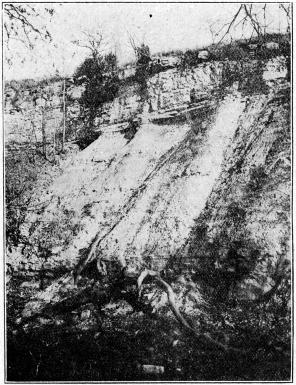
Along the sides of the valleys, and especially at their rims, are outcropping beds of thick limestone, which in many cases form an almost unsurmountable rampart at the tops of the valley slopes. Below the outcrops large and small limestone fragments which have been broken from the outcropping beds are strewn, The roughness of the country is reflected in the position of all the roads which either follow the divides (Saddleback road above the engineers camp, Rodney Hill and Sumner Hill roads, above Camp Funston), or ascend the valleys (Forsythe drive along Forsythe creek, roads ascending Magazine canyon, Pumphouse canyon, and other streams). (See map, Plate 1.)
Plate IV—Upland above Camp Funston, looking north.
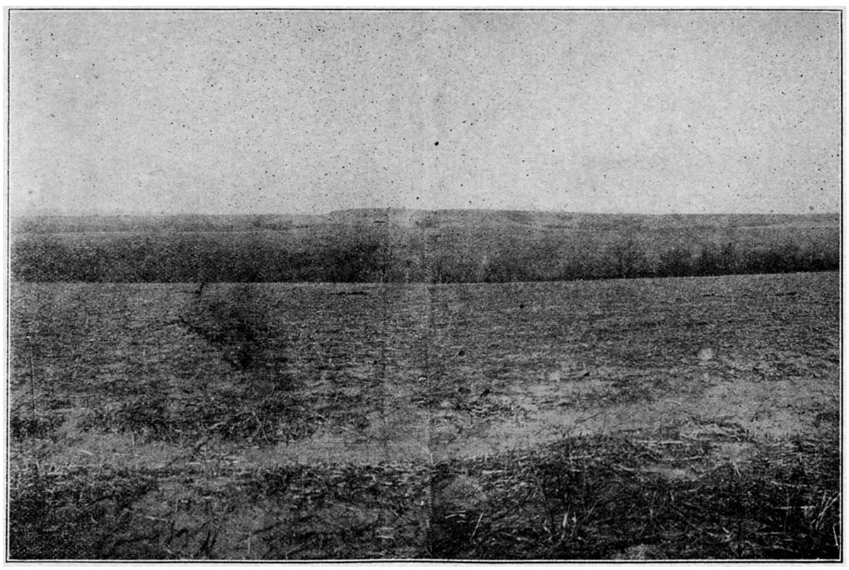
Plate V—Typical exposure of limestone and shale which compose the upland north of Camp Funston. Four Mile creek.
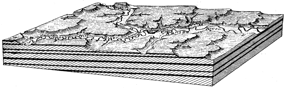
Much the most striking feature of the upland plain about Camp Funston, as viewed from a point on the river bluffs or from one of the narrow divides, is not, however, the rough, broken topography which one observes in ascending the valley roads to the uplands, but the evenness of the sky line, except where, here and there, a very slight descent marks the change from one general level to another. In the near vicinity the common height of the divides impresses the observer. Looking either north or south from the bluffs behind Camp Funston the country seems not unlike a series of immensely wide, flat stairs, with the low risers facing the east and long treads extending miles from east to west. The steps are, it is true, cut deeply in many directions by streams, large and small, which cross them, and more than merely casual observation is necessary to make them apparent. This succession of low stairs, or escarpments, is a characteristic feature of the plains of eastern Kansas, and is closely related to the structure of the rocks of which the plains are composed. (Fig. 17) It is a fact of special interest to the soldier, because, as shown in foregoing chapter, a great portion of the region in France which has become the battle ground of the present war is precisely similar in its major structural and topographic characters to the country about Camp Funston.
Figure 17—Block diagram showing rock structure and topography in the vicinity of Camp Funston. The hard rock layers (in black) dip gently to the west. The position of their outcrop is marked by east-facing escarpments. The large streams have cut valleys through the hard layers,
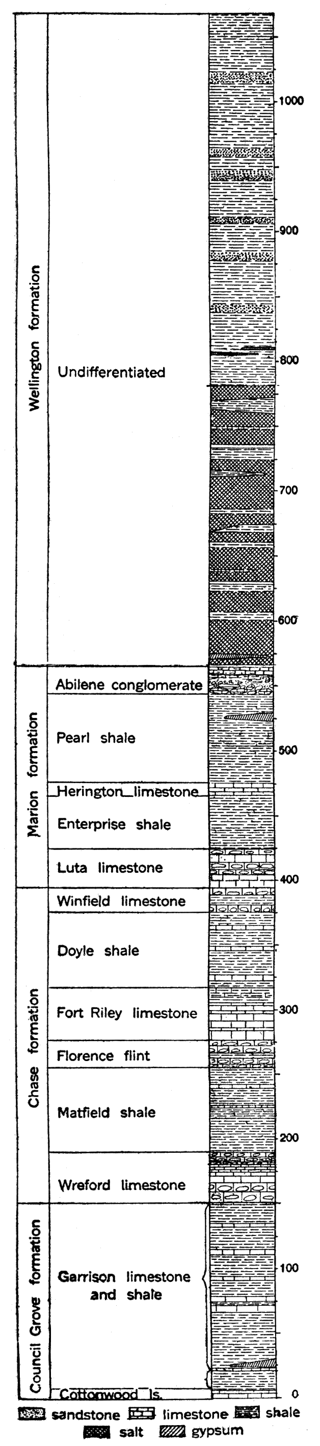
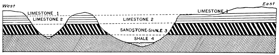
To understand the dependence of the upland plains topography on the rock structure it is merely necessary to point out that the level of the various divides almost invariably marks the position of a resistant bed of hard limestone. The rocks of the Camp Funston region consist of alternating beds of limestone and shale, the average thickness and position of which are shown in Figure 18. [Note: These rocks belong to the Permian division of geologists.] The beds are almost horizontal, having an inclination (dip) to the west amounting to only a few feet in a mile. Exposures of the hard limestone beds are very numerous about Camp Funston, and some of them are definitely continuous for miles. The soft shale beds, however, weather very quickly to form a soil which supports a thick cover of vegetation, and there are consequently few shale exposures. The limestone, because of its resistance to erosion, stands up in abrupt, steep slopes, and in most cases controls the position of the divides and of projecting benches in the topography. The parallelism between the height and shape of the hills and the position of the hard rock layers is evident at a glance. The shale, because it goes to pieces easily, forms long, gentle slopes.
Figure 18—Generalized section of the rocks exposed in the vicinity of Camp Funston, showing formation names used by geologists. All of the rocks belong to the Permian system.
The outcrops of the alternating limestones and shales (Plate VI) are very irregular, owing to the irregular courses of the streams which have cut into them. The block diagram, Figure 17, shows the structure of the rocks and their relation to surface topography. The bluff just north of Camp Funston is formed by the resistant Wreford limestone, which protects from erosion the softer underlying Garrison shale. The higher land farther north is capped by Florence flint. To the west the ledge of Wreford limestone descends to a lower and lower position until at Fort Riley it is only a slight distance above the level of the Kansas river flood plain. (Plate VI.) It forms a broad bench, on which the fort itself is built. (Fig. 12.) The high bluffs north and northeast of Fort Riley are capped by the hard Florence flint and Fort Riley limestone. The latter formation, named from the exposures in the Fort Riley military reservation, is the massive limestone which is most commonly observed in the bluffs and along the streams. It has been traced from Nebraska, the entire distance across Kansas to Oklahoma, and is everywhere known by the same name. It will be noted that in the west part of the reservation the Florence flint and Fort Riley limestone have come to within a short distance of the Republican river flood plain. This is due in part to the westward inclination of the rocks, in part to the westward rise of the flood plain.
Plate VI—Geologic map of region about Camp Funston.
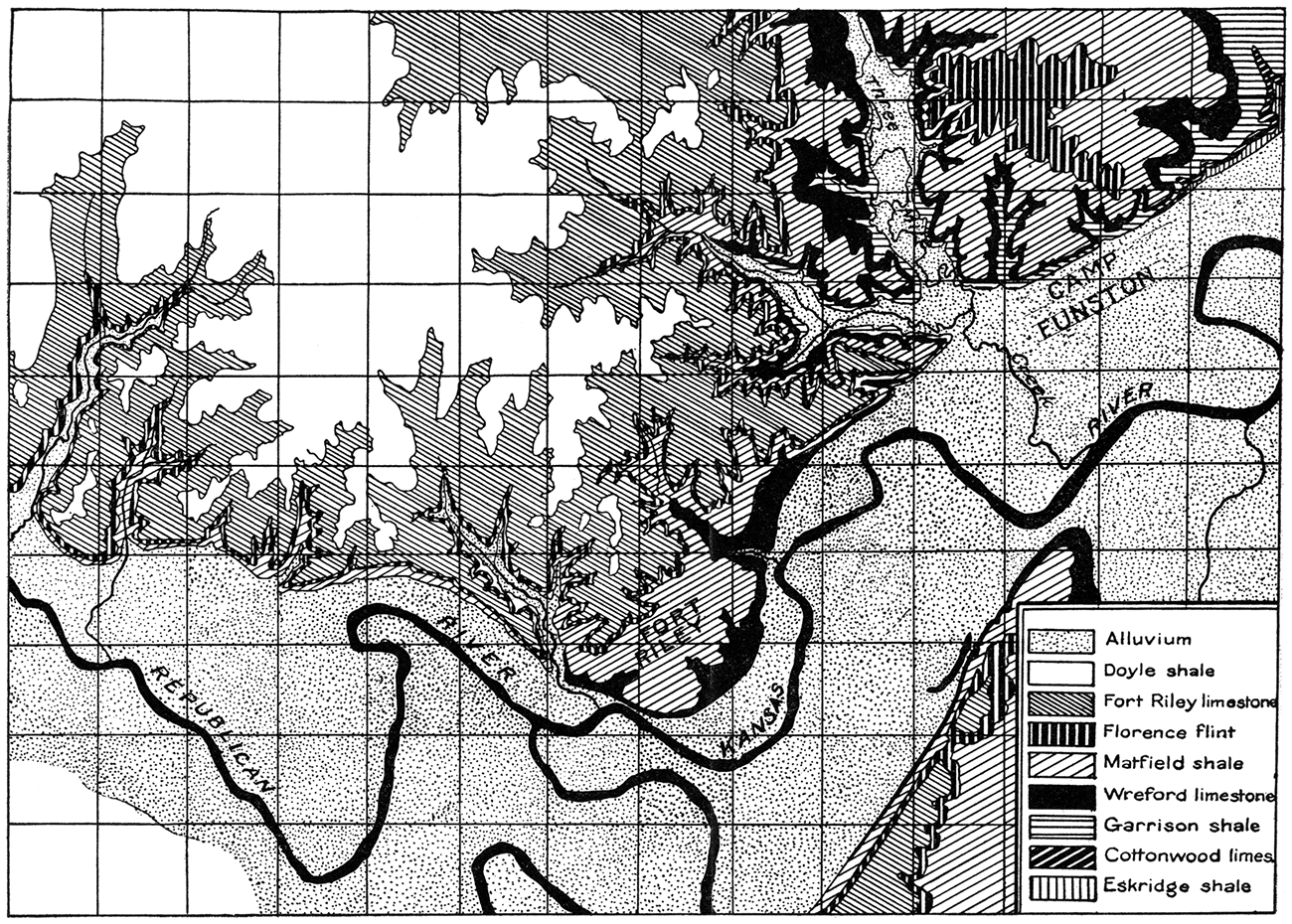
Plate VII—Topographic map of region about Soissons, France.
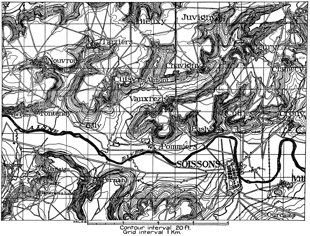
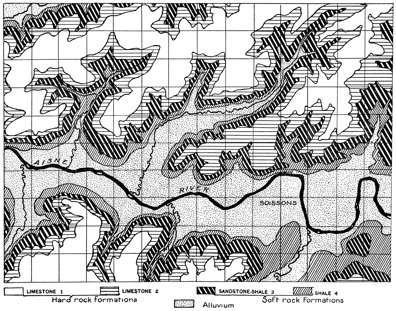
Plate VIII—Geologic map of region about Soissons, France.
The Wreford limestone, Florence flint and Fort Riley limestone are all valuable for road construction. The quarry at Packers hill, near the engineer's camp on Three Mile creek, and numerous quarries near Fort Riley have been used for this purpose. The Fort Riley limestone contains beds which are excellent for building purposes, and almost all of the permanent buildings of Fort Riley have been constructed from this rock.
The soil of the upland plain is in general rather thin, and it is due to this that the rocks outcrop in so many places. At many points on the divides there is hardly any soil at all and the bare rocks appear over large areas. On shale outcrops, such as that of the Doyle shale, which covers most of the northwest part of the reservation (Plate VI), soil is formed readily and the country is much better suited for farming. The soil of the upland supports a thick growth of prairie grass, but except for the rows of trees planted artificially along the divides it is treeless. Trees are very abundant, however, in all the draws, as shown in Plate I. The natural growth of trees in the ravines and draws is due to the larger amount of moisture in the ground there. The close dependence of tree growth on moisture supply and its relation to topography is of special interest because of the precisely similar distribution of forests in certain portions of France, where the conditions of rainfall are like those of the Camp Funston area.
Ground Water
Water suitable for drinking purposes is available a short distance from the surface in wells drilled almost any place, for the cracks and pores in the rock, clay, gravel and sand are, in general, full of water up to a certain level, this level being known as the ground-water surface or water table. (Fig. 33.) The ground water which supplies wells is rain water which has soaked into the soil and the material beneath it. When wells are sunk below the ground-water surface, water seeps into them from the surrounding rock, clay, sand or gravel. In general, in a region like the uplands above Camp Funston there is much more water in the cracks of the limestone than in the almost impervious shale beds between. The quantity of water in the soil and underlying rocks of the upland in north central Kansas is not as large as in regions of more abundant rainfall, and wells drilled here would not yield enough water to supply the needs of Camp Funston and Fort Riley. However, there is an entirely adequate quantity in the water which fills the spaces between the grains of sand and gravel in the valleys of Kansas, Republican and Smoky Hill rivers. This water is rain water which has sunk into the flood plain and water which has been brought down the river valleys and their tributary streams beneath the surface of the ground. The water in the open river or almost any stream is impure because of organic matter which is in it. The water beneath the river plain, however, filters very slowly through the sand and gravel, and is suitable for use in the camp. Its quantity is great enough for almost any requirements, as there is a continual new supply which is independent of local rainfall.
Figure 19—Profile across typical portion of upland northwest of Camp Funston. The elevation above sea level is shown at the left of the diagram.
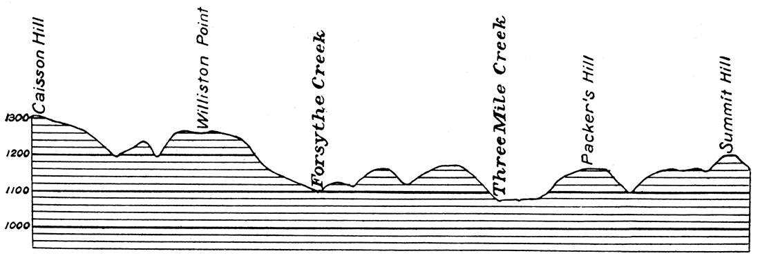
Figure 20—Geologic section of a portion of the upland north of Camp Funston, showing relation of hard limestone formations to topography. The formations are indicated as in Plate VI.
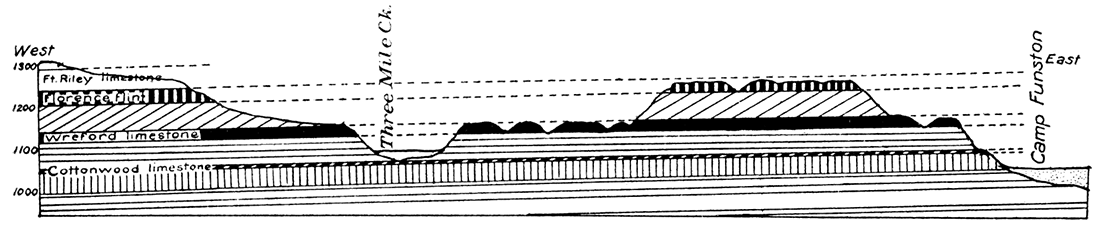
Figure 21—Geologic section across portion of the upland north of Soissons, France, showing the flat upland topography and steep bluffs produced by the hard limestone beds. Compare with Figure 20. The formations are indicated as in Plate VIII.
Climate
The soldier's interest in the climate of the region about Camp Funston lies chiefly in its effect on his comfort and activity, and how it compares with the climate he will find on the Western Front.
Like most other inland points in the great Mississippi valley, Camp Funston has a hot summer and a cold winter. The hottest month, July, has an average temperature' of 78.7° F. (25.9° C.), only slightly warmer than June and August. Some days at the camp are as hot as 100° to 105° F., the highest recorded temperature being 115° F. (46° C.). Such extreme temperatures fortunately are rare, but on account of the dryness of the air they are not so oppressive as they otherwise would be.
Figure 22—Diagram showing average monthly temperatures at Manhattan in degrees Fahrenheit. The highest average monthly temperature is in July, 79°, the lowest in January, 26°, a difference of 53°. The coldest temperature recorded is minus 32°, the hottest 115°, an extreme range of 147°. Warm summers and cold winters are characteristic of inland regions.
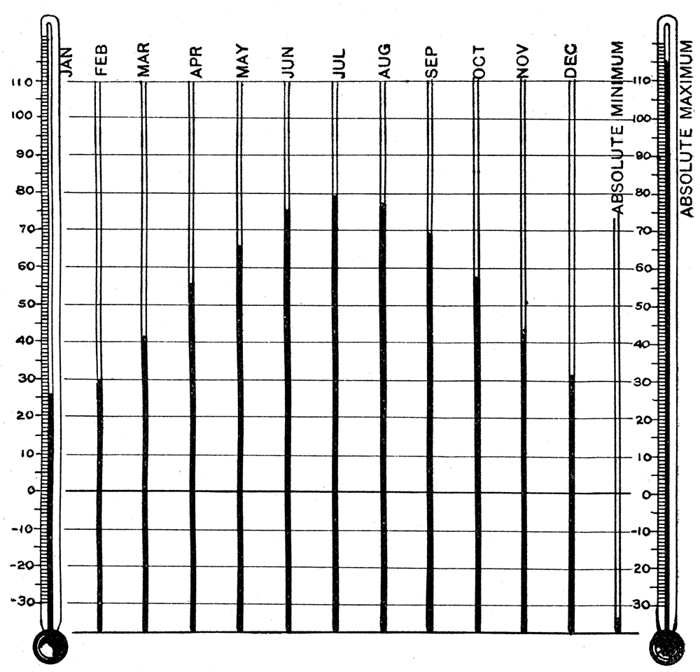
Figure 23—Diagram showing average monthly temperatures at Lille, France, in degrees Fahrenheit. The warmest month, July, has an average temperature of 65°, the coldest, January, 36°, a mean annual range of only 29°. The summers of northern France are much cooler than those of Camp Funston. The lowest temperature recorded at Lille is minus 2°, the highest 96°.
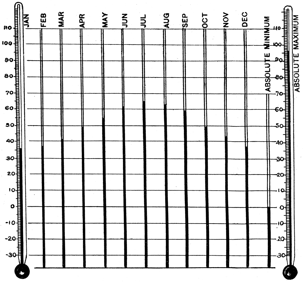
The coldest month, January, has an average temperature of about 25.9° F., only a few degrees below freezing, but there are many winter days in which the mercury drops for a time below zero. The lowest recorded temperature near Camp Funston (Manhattan) is 32° below zero, but such extremely cold days are as rare as the very hot days of summer. The changes in average temperature from month to month at Manhattan are shown in Figure 22, where the great difference between average summer and winter temperatures, 52.8° F. (29.3° C.), is indicated. The average monthly temperatures at Lille, France, are shown in Figure 23. There is a difference in the average temperature of summer and winter of but 27° F, (15° C.) at Lille. At Camp Funston there is a considerable daily temperature range throughout, the year; that is, it is hot or warm in the day, cool or cold at night. The mercury rises each day during July to an average of 93°, and falls to 63°, a range of 3Q.°. In northern France and Belgium, because these countries are close to the sea, the temperatures are much more equal, and the warmest part of the day is rarely more that 10° or 15° above the coolest. January at Brussels has an average temperature of 41 ° F. during the warm part of the days, but the coolest of the night is only 33° F., 8° cooler. These relations are shown in Figure 24.
Figure 24—Diagram showing average daily range of temperatures at Manhattan, Kan., and Lille, France. The average maximum temperatures each day recorded at Lille in July are only 15° above the average minimum, while the average daily range at Manhattan in the same month is nearly 30°.
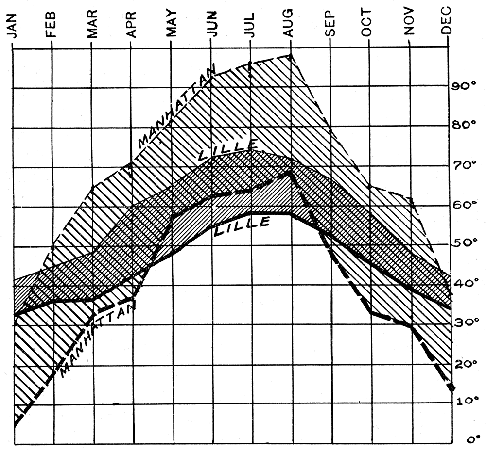
Plate IX—A. Quarry in Wreford limestone near Fort Riley. B. Stream cut in alluvium on One Mile creek, near Republican river.
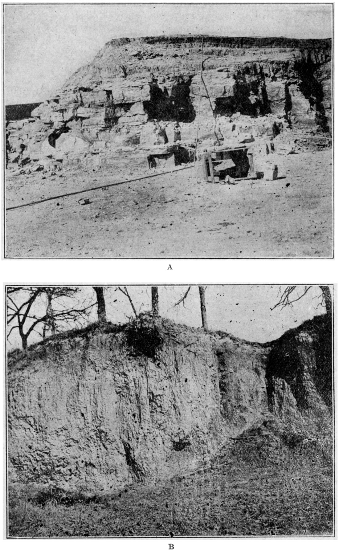
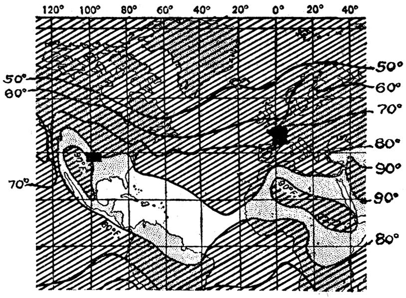
Figure 25—Map showing belts of equal temperature for January. Note that in winter Kansas and France have approximately the same temperature.
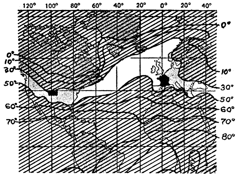
Figure 26—Map showing belts of equal temperature for July. Note that the temperature belt which includes Kansas is far south of France, where the summer temperatures are most like those of northern Canada.
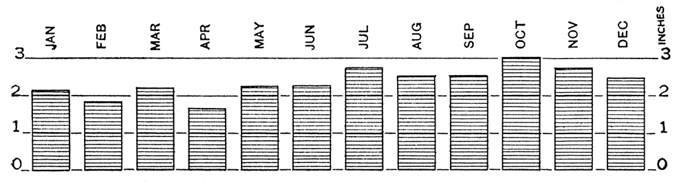
Rainfall, including the water of melted snow, has an average yearly total at Camp Funston of about 31 inches—less than in the country farther east, but greater than western Kansas and eastern Colorado. (Fig. 29.) About sixty-five days out of the year at Camp Funston are rainy. Much the greatest portion of the rain (Fig. 27) comes in the warm summer months as short, heavy showers, which make roads heavy and parade grounds and trenches muddy, Belgium and northern France have about the same amount of rain in a year as the region near Camp Funston, but unlike north-central Kansas, the rains there are spread very evenly through the year. (Figure 28.) In winter there is much more snow than rain at Camp Funston, the average thickness for the season being about 16 inches (equal to about 1.6 inches of rain). The prevailing winds, which are sometimes very hard, are uniformly from the southwest or south.
Figure 27—Diagram showing average monthly rainfall at Manhattan, Kan. Most of the rain of north central Kansas falls in the summer months. The winters are relatively dry.
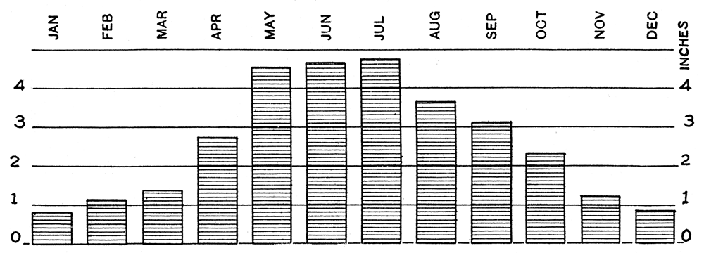
Figure 28—Diagram showing average monthly rainfall at Lille, France. While the total annual rainfall is approximately the same as that of Camp Funston note that the rainfall is approximately equally distributed through the year. The winters of northern France are wet.
France and Belgium are much farther north than Kansas. The battle area is almost entirely north of the northernmost limits of, the United States (excluding Alaksa). (Fig. 10.) Paris is nearly 700 miles farther north than Camp Funston and Brussels nearly 50 miles north of Winnipeg, Canada. The difference in longitude is such that noon at Paris is 6 o'clock in the morning at Camp Funston.
Because of the nearness of France to the ocean, which serves as a climatic equalizer, the winters of the battle area, despite the distance north, are milder than those of Kansas, and the summers much cooler than the summers of Camp Funston. The following paragraphs are an excellent summary of the weather conditions the soldier will meet in service on the Western Front. [Day, Preston C., Notes on the Climate of France and Belgium, U. S. Dept. of Agriculture, Monthly Weather Review, vol. 45, p. 493; October, 1917.]
From the standpoint of bodily comfort, the climate of northern France and Belgium may. be thus briefly summarized:
The winter weather is rather rigorous and unpleasant, due to the persistence of comparatively low temperatures, much cloudiness and frequent rain and snow. The winds blow mostly from the west or southwest and are frequently damp and chilly, the relative humidity, being rather high. The winter nights are long and the days correspondingly short. In the extreme northern portion of France, near the present battle line, the sun sets during the latter half of December a few minutes before 4 p.m. and rises about 8 a.m., making the nights, sunset to sunrise, about 16 hours long.
With the transition from winter to spring, the rapid warming up familiar to residents in most sections of the United States is not so noticeable in France and Belgium, the average temperature for March being only 2° to 4° F. higher than in February. April and May are moderately cool and not unpleasant, the length of the day increases much more rapidly than in most sections of the United States, and there is correspondingly large increase in the amount of sunshine, while rainfall is comparatively light, although occurring rather frequently.
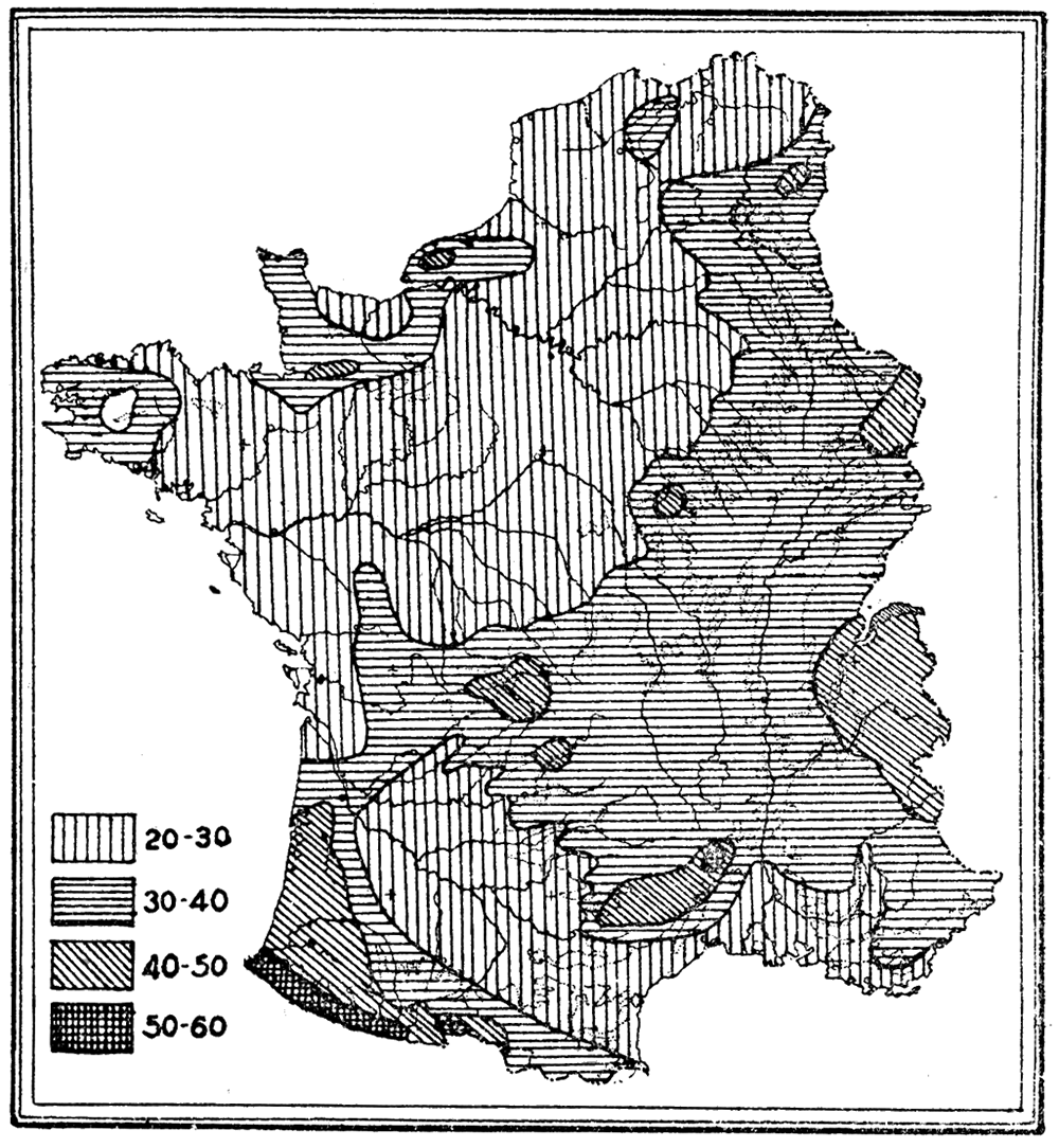
Figure 29—Map showing distribution of annual rainfall in the United States. In the open plains country of the Mississippi valley rainfall is much the same over great areas.
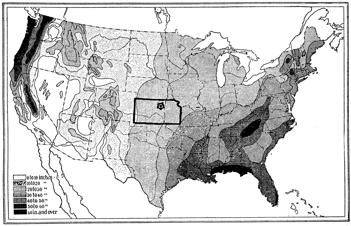
Figure 30—Map showing distribution of annual rainfall in France. The distribution of rainfall in Europe is very irregular. Even in a small country like France there is a rapid change from very wet to semiarid conditions.
The summers are pleasant as compared with much of the United States, the day temperatures being mostly moderate and the nights cool. Occasionally hot weather is experienced, but the heat is not excessive and the periods are usually of short duration. During the latter part of June the days in northern France and Belgium are more than 16 hours long, the sun rising a little earlier than 4 a.m. and setting after 8 p.m.
Fall also is usually pleasant, especially during September and October, the temperature during these months being, as a rule, considerably higher than for the corresponding spring months. With the advent of fall the rainfall usually becomes heavier, resulting more from greater intensity of falls than from increased frequency. This usually is the season of maximum rainfall.
Prev Page--Western Theater || Next Page--Military Significance
Kansas Geological Survey, Geology
Placed on web Feb. 12, 2018; originally published 1918.
Comments to webadmin@kgs.ku.edu
The URL for this page is http://www.kgs.ku.edu/Publications/Bulletins/4/03_funston.html