![]()
Prev Page--Contents || Next Page--Previous Research, Methods
Introduction
This study reconstructs the history of late Quaternary climate change and landscape evolution on the Great Bend Sand Prairie, a large sand sheet in south-central Kansas. Prior to this investigation, research of a similar nature had been conducted only in surrounding areas of the Great Plains, including northeastern Colorado, Wyoming, Nebraska, and Texas. As a result, little was known about the late Quaternary paleoenvironmental and geomorphic history of the sand sheets in Kansas, specifically the record of desertification and eolian sand mobilization. This lack of information has precluded prediction of landscape response should Kansas experience intensive drought in the future, as is anticipated by greenhouse-warming scenarios.
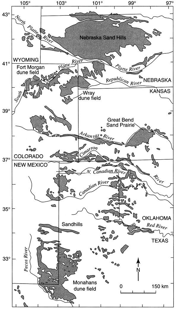
It is generally thought that increased levels of greenhouse gases (e.g., CO2, methane) in the atmosphere will result in global warming (e.g., Washington and Meehl, 1984; Hansen et al., 1988). Climatic modelling of greenhouse scenarios (e.g., Hansen et al., 1988; Schlesinger, 1989) has demonstrated that the degree of warming may reach levels reconstructed for the last few interglacials. Although the models show regional variation, greater warming is expected to cause increased dryness for the already subhumid to semiarid Great Plains (Hansen et al., 1988; Wetherald and Manabe, 1988; Wendland, 1993). Landscapes within the region that consist of unconsolidated sand are particularly sensitive to moisture loss because they easily destabilize when protective vegetation is reduced. This is significant within the context of regional warming because large portions of the Great Plains are mantled by sand dune fields and sand sheets (fig. 1) that are presently stable (e.g., Smith, 1940; Muhs, 1985, 1991; Madole, 1986, 1994; Holliday, 1989; Forman and Maat, 1990; Swinehart, 1990; Johnson, 1991).
Figure 1--Distribution of dune fields and sand sheets in the central Great Plains (modified from Muhs and Holliday, 1995).
Periodic desertification and mobilization of eolian sand has been demonstrated elsewhere in the Great Plains during the late Quaternary when intervals of drought reduced vegetative cover (Madole, 1986, 1994; Holliday, 1989; Swinehart, 1990). Dune migration apparently occurred during such cool-arid periods as the late Wisconsinan (e.g., Wright et al., 1985; Forman and Maat, 1990) as well as such warm-arid intervals as the middle Holocene (Ahlbrandt et al., 1983; Forman and Maat, 1990). The conditions under which these geomorphic ally sensitive areas would desertify again is the focus of increased speculation in response to predictions of greenhouse warming and drying (e.g., Swinehart, 1990; Forman and Maat, 1990; Johnson, 1991; Muhs, 1991; Forman et al., 1992).
Although late Quaternary paleoenvironmental reconstructions have been reported for sand sheets in northeastern Colorado (Muhs, 1985, 1991; Madole, 1986, 1994,1995; Forman and Maat, 1990; Forman et al., 1992), Nebraska (Ahlbrandt and Fryberger, 1980; Ahlbrandt et al., 1983; Swinehart, 1990), and Texas (Holliday, 1985, 1989), little is known about the response to climate change and the chronology of geomorphic events on sand-covered landscapes in Kansas. Significant portions of the southcentral and southwestern part of Kansas are mantled by unconsolidated sand. Most of this area is agricultural land, portions of which were destabilized and intensively eroded by wind during the dust bowl of the 1930's (Smith, 1938; Latta, 1950; Simonett, 1960). Although some research has been conducted in the dune fields of the region (e.g., Moore, 1920; Courtier, 1934; Smith, 1938, 1940; Simonett, 1960), it was generally descriptive in nature because of the lack of absolute dating techniques.
The largest sand sheet in Kansas, the Great Bend Sand Prairie (fig. 1), was chosen for detailed paleoenvironmental and geomorphic investigations because of its potential to provide significant baseline data for future studies. Increased levels of aridity are predicted for the future in the central Great Plains, including the Great Bend Sand Prairie, if greenhouse warming is realized. Because sand sheets have been especially sensitive to increased warming in the past (e.g., 1930's), understanding the timing and magnitude of landscape response is critical if destabilization is to be curtailed. Accordingly, the four specific objectives of this research were to (1) construct a detailed map of surficial geology; (2) determine the number, character, and relative ages of late Quaternary stratigraphic units; (3) reconstruct the history of paleoclimatic change by analyzing the sediments of major stratigraphic units; and (4) construct a chronology of desertification and sand mobilization on the Great Bend Sand Prairie and compare it with that derived from other sand sheets in the central Great Plains.
Study Area
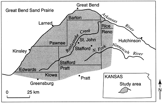
The research discussed in this report was conducted on the Great Bend Sand Prairie, a large sand sheet located within the "great bend" of the Arkansas River (fig. 1). Approximately 4,500 km2 (1,100 mi2) in size, it includes all of Stafford County, and portions of Barton, Edwards, Kiowa, Pratt, Reno, and Rice counties. The vast majority of investigations occurred within the jurisdiction of Groundwater Management District 5 (GMD 5). The study area is situated mostly within the Arkansas River Lowlands physiographic province, except for the southern onehalf of Pratt county, which lies in the High Plains physiographic province (Schoewe, 1949). Major tributaries to the Arkansas River in the region are the North Fork Ninnescah River, which flows generally to the southeast, and Rattlesnake Creek, a northeasterly trending stream that bisects the study area (fig. 2).
Figure 2--Location of major towns, county boundaries, and tributaries on the Great Bend Sand Prairie.
Geology
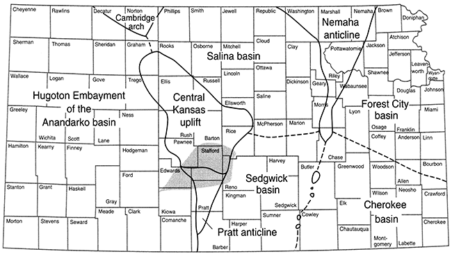
The geology of the Great Bend Sand Prairie is complex. Structurally, the study area lies on the southwestern flank of the Central Kansas uplift (Barton arch) and the northern one-half of the Pratt anticline (Merriam, 1963) (fig. 3). Basement rocks are Permian and early Cretaceous in age, with Cretaceous rocks present and forming the bedrock surface only in the western one-half of the study area. Permian rocks, consisting of the Ninnescah Shale, Stone Corral Formation, Harper Sandstone, Salt Plain Formation, Cedar Hills Sandstone, and undifferentiated strata (including Whitehorse and Dog Creek Formations) are often referred to as "red beds" because they contain red to brown shale, siltstone, and sandstone with minor beds of limestone, dolomite, and anhydrite. Cretaceous rocks include the Cheyenne Sandstone, Kiowa Formation, and Dakota Formation, and generally consist of interbedded shales, sandy shales, and fine- to coarse-grained sandstones.
Figure 3--Structural elements of Kansas portraying the position of the Great Bend Sand Prairie (screened area) relative to the Central Kansas uplift and Pratt anticline.
Overlying the Permian and Cretaceous basement rocks on the Great Bend Sand Prairie are varying thicknesses of unconsolidated Tertiary and Quaternary deposits. Tertiary deposits consist of the Pliocene Ogallala Formation. In general, the Ogallala is characterized by deposits of silt and fine sand with interbedded caliche that were derived from the Rocky Mountains (Fader and Stullken, 1978).
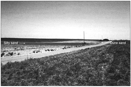
The surficial geology of the entire Great Bend Sand Prairie is dominated by unconsolidated Quaternary deposits of eolian and alluvial origin. Quaternary sediments of the region have a maximum thickness of about 110 m (360 ft) (table 1). The kinds of minerals (e.g., quartz, feldspar, granite) found in most Quaternary deposits suggests a Rocky Mountain origin with the Arkansas River serving as the primary source. The bend of the Arkansas River is thought to have migrated laterally from the south to its present position via successive captures by its own northern tributaries, leaving a thick deposit of sand, silt, and clay behind (Fent, 1950). In general, five lithostratigraphic units have been recognized (bottom to top): (1) basal sand and gravel; (2) alternating sequences of sandy silt-clay, sand, and gravel; (3) nearsurface silt-clay bed; (4) loess; and (5) dune sand (Rosner, 1988). Of specific concern in this study is the surficial mantle of dune sand, from 0 m to 15 m (0-49 ft) thick (Johnson, 1991), and its relationship to underlying deposits of silt-clay and loess (e.g., fig. 4).
Table 1--Generalized columnar section of geologic units on the Great Bend Sand Prairie (modified from Fader and Stullken, 1978).
| System | Geologic Unit | Maximum thickness (m) |
Physical Character |
|---|---|---|---|
| Quaternary | undifferentiated Pleistocene deposits |
110 | Unconsolidated deposits of sand and gravel with interbedded lenses of clay, silt, and caliche. Eolian sand occurs over most of the area. |
| Tertiary | Ogallala Formation (Pliocene deposits) |
20 | Unconsolidated deposits of silt, fine sand, and interbedded caliche. |
| Cretaceous | undifferentiated Lower Cretaceous rocks |
115 | Upper unit (Dakota Formation): brown, fine- to medium-grained sandstone interbedded with shale. Middle unit (Kiowa Formation): dark-gray shale interbedded with sandstone. Lower unit (Cheyenne Sandstone): gray to brown medium-grained sandstone interbedded with shale. |
| undifferentiated Permian rocks |
105 | Interbedded reddish shale, siltstone, and sandstone. | |
| Cedar Hills Sandstone | 60 | Reddish shale, siltstone, and sandstone. | |
| Salt Plain Formation | 90 | Reddish-brown sandy siltstone and sandstone. | |
| Permian | Harper Sandstone | 75 | Brownish-red siltstone and silty shale. |
| Stone Coral Formation | 5 | White and light-gray anhydrite and dolomite. | |
| Ninnescah Shale | 120 | Red and grayish-green shale, siltstone, and silty sandstone. |
Figure 4--Outcrop of silty sand in a dune field in the NW NW sec. 24, T. 26 S., R. 15 W. (modified from Arbogast and Johnson, 1998).
Soils
Soils within the Great Bend Sand Prairie are classified as Mollisols, Alfisols, Entisols, or Inceptisols. Categorization is based on landscape position and parent-material associations. Upland soils have formed in undulating to hilly sandy sediments; in so-called old alluvium that is predominantly sandy clay loam, silty clay loam, and clay loam in texture; and in loess. Floodplain soils are those that have developed in areas with a seasonally high water table or in stream drainageways (or both).
The best-developed soils in the study area are Typic Argiaquolls (Carwile Series), Udic Argiustolls (Naron Series), Pac hie Argiustolls (Blanket and Farnum Series), and Vertic Argiustolls (Tabler Series). These soils are loamy, generally considered to have formed in old alluvium, and occur on the broad landscapes of relatively low relief between large dune fields. Soils in the Tabler Series have the finest texture, generally occupy depressional positions, and are the least well drained. Carwile soils occur in similar topographic positions as Tabler soils but are more coarse textured and slightly better drained. Naron and Farnum soils contain the highest proportions of sand, occupy slightly higher landscape positions, and are better drained. Blanket soils are found only in Stafford County where a significant deposit of loess occurs.
Soils that have evolved in the complex, windmodified dune topography of the study area consist of Psammentic Haplustalfs (Pratt Series), Typic Ustipsamments (Tivoli Series), and Aquic Ustipsamments (Dillwyn Series). Each has formed in sediments classified as loamy fine sand. Dillwyn soils are deep, somewhat poorly drained soils in interdunes where seasonal water tables are relatively high. Pratt soils are well drained and occupy the lowest, least erodable slopes on dunes. Tivoli soils are also well drained but are found on dune crests where eolian erosion is most likely to occur. As a result, these soils have the poorest development of any series in the region.
Soils that have formed in younger, fluvial landscapes are classified as Fluvaquentic Haplustolls (Plevna Series) and Leptic and Typic Natrustolls (Natrustolls). Natrustolls developed in loamy, calcareous alluvium that contains layers of sand or clay in places. They are somewhat poorly drained and often contain high concentrations of salt. Seasonal water tables are relatively high. Plevna soils are often heavily gleyed and typically have developed in slight depressions on floodplains and on chaotic, channeled floodplains. Parent material is usually fine, sandy loam at the surface that is underlain by sandy and clayey alluvium (Dodge et al., 1978).
Climate
Several stations (e.g., Great Bend, Hutchinson, Greensburg, Hudson, Larned) near or on the Great Bend Sand Prairie have maintained temperature and precipitation records since early in this century. Data indicate that the present climate of the region is semiarid to subhumid and strongly continental, characterized by extreme diurnal and annual variations in temperature. Winter usually lasts from December to February with an average low temperature of about 0°C. The summer growing season is usually from April to October, during which time the average high temperature is about 25.5°C. Average annual precipitation in the study area reflects the position of the Great Bend Sand Prairie on the boundary between the dry portion of western Kansas that is influenced by the rain shadow of the Rocky Mountains and the eastern regions over which moisture-laden air from the Gulf of Mexico flows. Although yearly precipitation may vary widely depending upon the precise position of the boundary, mean annual precipitation on the western border (57 cm; 22 in) is significantly less than average yearly rainfall on the eastern margin of the study area (80 cm; 32 in) (Fader and Stullken, 1978). Most of the total annual precipitation comes from convective storms in the late spring and summer, with approximately 75% of the yearly amount occurring in the growing season (table 2).
Table 2--Mean monthly temperature and precipitation at Hudson. Data from Dodge et al. (1978, p. 56).
| Temperature (°C) | Precipitation (mm) |
||
|---|---|---|---|
| Mean Daily Max. | Mean Daily Min. | ||
| J | 6.0 | -7.0 | 1.4 |
| F | 9.0 | -4.4 | 2.3 |
| M | 13.0 | -1.2 | 3.2 |
| A | 20.5 | 5.9 | 5.8 |
| M | 25.9 | 12.0 | 9.2 |
| J | 31.2 | 17.1 | 10.8 |
| J | 34.0 | 18.9 | 9.3 |
| A | 33.3 | 18.9 | 6.5 |
| S | 28.3 | 14.0 | 5.6 |
| 0 | 22.2 | 7.7 | 5.3 |
| N | 13.3 | 0.0 | 2.0 |
| D | 6.8 | -4.5 | 2.2 |
Vegetation
Vegetation on the Great Bend Sand Prairie can be separated into that which was native to the area and that which was imported by European settlers (Kuchler, 1974). Land-use data for Stafford County serve as an estimate for this division between native and cultivated vegetation on the Great Bend Sand Prairie. In 1978, approximately 375,000 acres, or about 75% of the total land area in Stafford County, was under cultivation; 96,000 acres, or about 19% of the total land area was in pasture. The remaining 6% of the land, such as along the Rattlesnake Creek floodplain, was regarded as unsuited for agriculture. Pasture in Stafford County is generally located on the very well drained, dune topography of high relief, while cultivated land is found nearly everywhere.
Grassland, in the form of tall- and mixed-grass prairie, dominates the study area, although wooded areas exist along streams. Common native prairie grasses in high-relief dune fields include sand bluestem (Andropogon hallii), little bluestem (Andropogon scoparius), sand lovegrass (Eragrostis trichodes), big sandreed (Calamovilfa gigantea), switch grass (Panicum virgatum), indian grass (Sorghastrum nutans), sand dropseed (Sporobolus cryptandrus), and Texas bluegrass (Poa arachnifera). In areas of less relief, where better-developed, heavier soils are found, big bluestem (Andropogon gerardii), western wheatgrass (Agropyron smithii), blue grama (Agropyron hallii), side-oats gramma (Bouteloua curtipendula), tall drop seed (Sporobolus giganteus), and buffalo grass (Buchloe dactyloides) are common. Riparian trees in the Great Bend Sand Prairie include eastern cottonwood (Populus deltoides), American elm (Ulmus rubra), common hackberry (Celtis occidentalis), sycamore (Platanus occidentalis), black hickory (Carya texana), and black walnut (Juglans nigra) (Dodge et al., 1978).
Cultural History
Archaeological evidence recovered from the Great Bend Sand Prairie indicates human inhabitation during the past several thousand years. Eighteen prehistoric sites have been identified thus far, dating back to the Archaic, and Middle and Late Ceramic. Tool assemblages, consisting largely of projectile points and flakes, suggest the region served as a hunting ground. The Great Bend Sand Prairie was intermittently inhabited by nomadic bands of Native American Wichita, Cheyenne, Comanche, Kiowa, and Kiowa Apache during the protohistoric (Logan et al., 1993).
Large-scale European influence in the region began during the 1820's with establishment of the Santa Fe Trail along the northern boundary of the study area. In order to protect the trail, Fort Larned was established in 1859 near the site of present-day Larned, Kansas. By the late 1860's, homesteaders from the eastern United States and Europe began to settle the area during the large westward migration. Migration was fueled by the establishment of the Santa Fe Railroad, which reached the town of Great Bend in 1872 (Dodge and Roth, 1978).
By 1900 the area was fully settled by European settlers. Pratt, Reno, Barton, and Edwards counties were established in 1872, whereas Edwards and Stafford counties were organized in 1874 and 1879, respectively (Andreas, 1883). Kiowa County was established in 1886 (Hoffman et al., 1986). According to the 1990 census, the largest cities in the region are Great Bend (pop. 15,427), Pratt (pop. 6,687), Larned (pop. 4,445), Greensburg (pop. 1,792), St. John (pop. 1,274), and Stafford (pop. 1,268). Although some oil and gas speculation occurs in the area, the regional economy is largely based on farming, ranching, and related enterprises (Kansas Statistical Abstracts, 1992).
Prev Page--Contents || Next Page--Previous Research, Methods
Kansas Geological Survey, Geology
Placed on web March 16, 2016; originally published 1998.
Comments to webadmin@kgs.ku.edu
The URL for this page is http://www.kgs.ku.edu/Publications/Bulletins/242/02_intro.html