![]()
Prev Page--Results, Continued || Next Page--References
Discussion and Conclusions
Chronology of Late Quaternary Landform Evolution and Paleoenvironmental Change
After analyzing and integrating the data collected from the Great Bend Sand Prairie, a full reconstruction of late Quaternary landform evolution and paleoenvironmental change on uplands is possible. Given the lack of reliable dating techniques, earlier studies of dune fields in Kansas were largely qualitative in nature and based upon outdated glacial chronologies. Because of the high number of radiocarbon ages obtained in this study (tables 3, 4), previously accepted theories regarding landscape evolution in the region have been significantly revised. The chronology is organized in three parts: late Wisconsinan (ca. 21,000-10,000 yr B.P.), early to middle Holocene (ca. 10,000-4,000 yr B.P.), and late Holocene (4,000 yr B.P.Present).
Table 4--Radiocarbon ages used to estimate the age of buried soils in silty sand, loess, and dune sand on the Great Bend Sand Prairie. All ages from soils were obtained on the base soluble fraction of total soil humates, except for Tx-6479*, which was derived from charcoal. Abbreviations: ds = dune sand; uss = upper silty sand; lss = lower silty sand.
| Location | Stratigraphic unit |
Horizon (depth) |
Lab no. (Tx-) |
Uncorrected 14C age |
δ13C-corrected 14C age1 |
δ13C (‰) |
Calibrated age2 |
|---|---|---|---|---|---|---|---|
| Buster Dune3 | ds | 2Ab (0.82-0.87) | 7980 | modern | modern | -17.9 | modern |
| Harvey/Reno3 | ds | 2Ab (1.47-1.52) | 7828 | 40 ± 100 | 210 ± 100 | -14.2 | 320 (160) 60 |
| Stafford 63 | ds | 2Ab (0.53-0.58) | 7983 | 110 ± 80 | 270 ± 80 | -15.2 | 464 (299) 146 |
| Rice Roadcut3 | ds | 2Ab (1.28-1.33) | 7978 | 230 ± 80 | 380 ± 80 | -16.0 | 504 (467) 315 |
| Stafford 63 | ds | 3Ab (1.13-1.18) | 7982 | 320 ± 100 | 480 ± 100 | -15.0 | 560 (510) 320 |
| Rice Roadcut3 | ds | 2Ab (1.69-1.74) | 7977 | 340 ± 80 | 490 ± 80 | -15.9 | 559 (517) 454 |
| Stafford 63 | ds | 3Ab (1.47-1.52) | 7981 | 360 ± 80 | 550 ± 80 | -13.4 | 644 (542) 507 |
| Reno 33 | ds | 3Ab (2.57-2.62) | 8119 | 520 ± 80 | 700 ± 80 | -14.4 | 701 (657) 554 |
| Reno 43 | ds | 2Ab (1.10-1.15) | 8012 | 510 ± 80 | 710 ± 80 | -12.4 | 717 (660) 556 |
| GMD 5 #24 | uss | 2Ab (1.63-1.68) | 9743 | 660 ±60 | 810 ± 120 | -15.5 | 910 (700) 650 |
| Crocket Cutbank3 | ds | 3Ab (5.88-5.93) | 8214 | 750 ± 80 | 880 ± 80 | -16.6 | 913 (774) 695 |
| Stafford 23 | ds | 2Ab (1.14-1.19) | 9313 | 840 ± 80 | 1,030 ± 80 | -13.3 | 1,056 (936) 792 |
| 14KW73 | ds | 2Ab (5.12-5.17) | 7777 | 920 ± 60 | 1,090 ± 120 | -14.5 | 1,170 (970) 910 |
| Stafford 113 | uss | 3Btb1 (1.07-1.12) | 8218 | 1,350 ± 80 | 1,500 ± 80 | -15.7 | 1,502 (1,354) 1,301 |
| Buster Quarry3 | ds | 3Ab (4.55-4.60) | 7979 | 1,350 ± 100 | 1,500 ± 100 | -15.8 | 1,510 (1,350) 1,300 |
| GMD 5 #74 | uss | 2Ab (1.02-1.07) | 6744 | 1,440 ± 160 | 1,620 ± 160 | -14.7 | 1,700 (1,520) 1,340 |
| GMD 5 #104 | uss | 2Ab (1.43-1.48) | 7700 | 2,130 ± 140 | 2,250 ± 140 | -17.3 | 2,360 (2,230) 2,020 |
| Cornwell Trench3 | ds | 2Ab (1.48-1.53) | 7998 | 2,140 ± 100 | 2,310 ± 100 | -14.3 | 2,380 (2,340) 2,150 |
| Phillips Trench3 | uss | 2Btb1 (0.33-0.38) | 8216 | 2,250 ± 100 | 2,400 ± 130 | -15.8 | 2,710 (2,360) 2,330 |
| Edwards 43 | uss | 3Btb1 (1.60-1.65) | 8314 | 2,610 ± 90 | 2,730 ± 180 | -17.3 | 3,080 (2,790) 2,710 |
| GMD 5 #104 | uss | 2Ab (1.43-1.48) | 6745 | 2,810 ±l60 | 2,940 ± 160 | -17.0 | 3,450 (3,070) 2,750 |
| Edwards 13 | uss | 2btb1 (1.15-1.20) | 8003 | 1,690 ±80 | 3,220 ± 80 | -13.2 | 3,555 (3,425) 3,349 |
| Crocket Cutbank3 | ds | 3C5 (8.06-8.11) | 8215 | 3,160 ± 50 | 3,280 ± 100 | -17.7 | 3,630 (3,470) 3,380 |
| Cullison Quarry3 | uss | 3Btb1 (4.70-4.75) | 8221 | 3,660 ± 100 | 3,820 ± 100 | -14.8 | 3,822 (3,677) 3,478 |
| GMD 5 #74 | uss | 2Ab (2.02-2.07) | 6877 | 4,530 ± 160 | 4,620 ± 160 | -16.6 | 4,400 (4,180) 4,000 |
| GMD 5 #94 | uss | 2Ab (1.30-1.35) | 6477 | 4,680 ± 200 | 4,840 ± 200 | -15.2 | 6,290 (6,180) 5,990 |
| Reno 43 | uss | 3Btb1 (2.27-2.32) | 8011 | 5,260 ± 120 | 5,370 ± 120 | -17.7 | 7,020 (6,720) 6,390 |
| GMD 5 #94 | uss | 2Ab (1.40-1.45) | 6478 | 5,740 ± 300 | 5,870 ± 300 | -17.6 | 7,210 (7,020) 6,860 |
| Stafford 33 | ds | 2Ab (1.96-2.01) | 8118 | 6,050 ± 160 | 6,160 ± 160 | -17.9 | 7,900 (7,690) 7,580 |
| Belpre Trench | uss | Bt3 (0.95-1.00) | 8009 | 6,850 ± 140 | 6,930 ± 140 | -20.2 | 8,440 (8,340) 8,130 |
| Cullsion Quarry3 | lss | 4Btgb1 (5.65-5.70) | 8220 | 7,770 ± 140 | 7,850 ± 140 | -20.0 | 8,950 (8,560) 8,780 |
| Belpre Trench | lss | Btk8 (2.20-2.25) | 7975 | 8,490 ± 160 | 8,550 ± 160 | -21.0 | 9,840 (9,490) 9,370 |
| Edwards 13 | lss | 3Btb1 (1.65-1.70) | 7697 | 8,990 ± 560 | 9,050 ±560 | -22.2 | 10,883 (10,000) 9,453 |
| Reno 5 | lss | 4C1 (3.10-3.15) | 8013 | 8,910 ± 260 | 9,160 ± 260 | -9.5 | 10,387 (10,040) 9,905 |
| Stafford 23 | lss | 4Btb (3.08-3.13) | 8117 | 10,440 ± 720 | 10,460 ± 720 | -23.6 | 13,096 (12,370) 10,964 |
| Stafford 113 | lss | 3Btb4 (1.82-1.87) | 8219 | 10,970 ± 180 | 1l,100 ± 180 | -16.5 | 13,230 (13,010) 12,810 |
| Stafford 4 | lss | 2Ab (1.66-1.71) | 7999 | 12,640 ± 340 | 12,820 ± 340 | -14.2 | 15,710 (15,150) 14,560 |
| Edwards 3 | lss | 4Btkb (2.72-2.77) | 8115 | 13,280 ± 780 | 13,290 ± 780 | -24.7 | 16,840 (15,870) 14,690 |
| GMD 5 #14 | uss | 2Ab (2.49-2.54) | 6742 | 13,620 ± 560 | 13,670 ±1,340 | -20.9 | 17,939 (16,380) 14,389 |
| Edwards 3 | lss | 3Btkb (1.79-1.84) | 8116 | 15,260 ± 680 | 15,250 ± 680 | -25.6 | 18,836 (18,170) 17,429 |
| Reno 43 | lss | 3Btb3 (3.50-3.55) | 8010 | 16,590 ±360 | 16,670 ±360 | -19.9 | 20,260 (19,450) 18,960 |
| Stafford 1 | uss | 2btb1 (0.98-1.03) | 7679 | 16,760 ±440 | 16,810 ± 440 | -21.9 | 20,593 (19,830) 19,213 |
| GMD5 #94 | lss | 2Bk2 (2.02) | 6479* | 17,950 ±660 | 17,970 ±660 | -23.7 | 22,300 (21,450) 20,510 |
| Edwards 2 | uss | 2btb1 (1.23-1.28) | 7698 | 19,370 ± 1,000 | 19,460 ±1,000 | -19.8 | na |
| Stafford 10 | lss | 3Btb (1.45-1.50) | 8114 | 20,150 ± 740 | 20,230 ± 740 | -20.1 | na |
| Belpre Trench | lss | Btkg13 (3.44--3.49) | 7976 | 20,620 ± 500 | 20,670 ± 500 | -22.3 | na |
| 1. For a discussion of the δ13C-correction procedure, see Stuiver and Polach (1977) and Taylor (1987). 2. Calibrated from conventional δ13C-corrected radiocarbon age to calendar years using a tree-ring curve. All calibrations reported here were based upon the 20-year atmospheric curve (e.g., Linick et al., 1985; Stuiver et al., 1986). Program used is discussed in Stuiver and Reimer (1993). 3. Reported in Arbogast (1996b). 4. Reported in Johnson (1991). |
|||||||
Late Wisconsinan (ca. 21,000-10,000 yr B.P.)
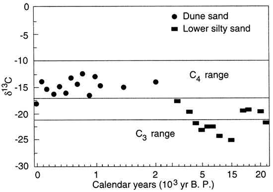
According to Arbogast and Johnson (1998), data obtained from late Wisconsinan deposits imply that the environment was more mesic than during the Holocene. The only macrofloral sample (white-spruce charcoal) of Woodfordian age indicates the presence of conifers during the glacial maximum (Johnson, 1991). The assemblage of faunal macrofossils (e.g., Discus cronkhitei, Succinea avara, an aquatic bivalve) further suggests that the environment was mesic because these species are presently extant only in the subalpine taiga of the Rocky Mountains (Leonard, 1952; Bequaert and Miller, 1973) and the more humid southeastern and northeastern parts of North America (Leonard, 1952) (fig. 60). Finally, values of δ13C derived from Woodfordian deposits generally range from -25‰ to -17‰, suggesting that C3 plants were more prevalent (fig. 61).
Figure 60--Present distribution of Discus cronkhitei in North America (modified from Leonard, 1952).
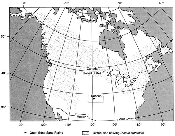
Figure 61--Distribution of δ13C values and radiocarbon age from the lower silty sand and dune sand on the Great Bend Sand Prairie (modified from Arbogast and Johnson, 1998).
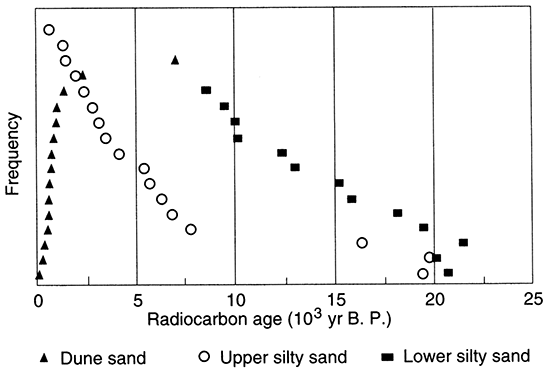
During the Woodfordian the cool, relatively moist environment apparently promoted accumulation of a very poorly sorted, generally noncalcareous deposit of sand, silt, and clay (silty sand) on the Great Bend Sand Prairie. A total of 13 radiocarbon ages were derived from the lower part of silty sand (i.e., sample locations buried by additional deposits of silty sand) exposed in backhoe trenches. Eleven of these ages range from about 24,000 yr B.P. to 10,000 yr B.P. (fig. 62). The extremely widespread silty sand underlies most of the study area but varies considerably in texture from a spatial perspective. At some localities (e.g. Edwards 4), the silty sand is consistently 60% sand, whereas at others (e.g., Reno 4, Belpre Trench) the deposits contain as much as 80% silt or 40% clay. The majority of study sites exhibit at least one, but typically two or three, fining-upward sequences. Overall, the spatial variability in the silty sand suggests lateral differences in facies. Fining-upward sequences within the silty sand at specific sites imply that subtle change in depositional regime also occurred on a temporal basis (Arbogast and Johnson, 1998).
Figure 62--Radiocarbon ages and stratigraphic position on the Great Bend Sand Prairie (modified from Arbogast and Johnson, 1998).
It is difficult to determine with certainty the process which resulted in accumulation of the silty sand. At Cheyenne Bottoms, Fredlund (1995) reported a major unconformity between Farmdalian and Holocene deposits, which he argued occurred because climate was more arid and surface winds were stronger in the Woodfordian than in the Holocene. In general, results from this study contradict Fredlund's (1995) conclusions because the silty sand is so pervasive and demonstrably Woodfordian in age. Unfortunately, no diagnostic sedimentary structures were discerned in the silty sand in any of the sites studied.
There is indirect evidence, according to Arbogast and Johnson (1998), that the silty sand may be an eolian deposit. Specifically, the high percentages of silt in much of the silty sand suggest an eolian source, at least in part, because substantial deposits of Peoria loess accumulated in the central Great Plains during the Woodfordian (Frye and Leonard, 1952; Wells and Stewart, 1987; Johnson, 1993; Johnson et al., 1993), including sites immediately north (Barton County Landfill) and south (Pratt County Landfill) of the study area (Feng, 1991; Feng et al., 1994). Given the documented presence of Peoria loess surrounding the study area, deposition of eolian silt probably occurred on the Great Bend Sand Prairie as well (Arbogast and Johnson, 1998). In fact, Peoria loess may exist in scattered localities in the region, as suggested by deposits of buff-colored, relatively calcareous silt recognized at the Belpre Trench, Phillips Trench, and the south flank of Wilson Ridge. At the Belpre and Phillips Trenches, the silt overlies a buried soil considered to be equivalent to the Gilman Canyon Formation (Reed and Dreeszen, 1965), based upon a radiocarbon age of about 21,000 yr B.P. from the Belpre Trench. In addition, landsnails comparable to those described elsewhere in the Peoria loess (e.g., Leonard, 1952; Wells and Stewart, 1987) were recovered from the deposits at both localities.
Arbogast and Johnson (1998) also suggested that the silty sand may also, in part, be an eolian deposit similar to cover sands in Alaska (Lea and Way thomas, 1990) and Europe (e.g., Koster, 1988; Schwan, 1988), which accumulated downwind of glacial outwash streams. Given the position of the Arkansas River generally to the north of the Great Bend Sand Prairie and the prevailing northwesterly winds of the Woodfordian, the floodplain certainly could have been a source for eolian sediment.
Although eolian processes probably contributed to the silty sand, Arbogast and Johnson (1998) argued that the majority of evidence suggests that fluvial processes potentially dominated the Woodfordian depositional regime. The silty sand differs from cover sand in its lack of stratification and its very high clay content at some sites. Additionally, the surface of the unit is sharply and very unevenly truncated at two sites (e.g., Edwards 3, Stafford 10), suggesting that flowing water was responsible for erosion. These characteristics, coupled with the many fining-upward sequences and very poor sorting (Friedman, 1967), implied to Arbogast and Johnson (1998) that sedimentation largely occurred in a low-energy fluvial system. Given the textural variability in the silty sand throughout the study area, it appears that the facies included main channel, secondary channel, and backswamp. Radiocarbon ages from trench 6 (figs. 51-53) at Wilson Ridge indicate the presence of at least one playa in the region during the late Wisconsinan. Although it is impossible to determine with the data now available, perhaps the study area was covered by a series of interconnected lakes with a very low gradient. Such a scenario is logical and may account for the near ubiquity of the silty sand, while allowing for the tremendous spatial and random diversity in the deposit.
The discrepancy between Fredlund's (1995) conclusions and the results of this study are interesting and, according to Arbogast and Johnson (1998), may shed further light on depositional processes associated with the silty sand on the Great Bend Sand Prairie. Given that Fredlund's (1995) data were derived from only one core, they may be biased. If, however, a major Woodfordian unconformity does exist at Cheyenne Bottoms, Arbogast and Johnson (1998) argued that it should also exist on the Great Bend Sand Prairie because of their proximity (<20 km; 12.4 mi) and topographic similarity (i.e., poorly drained lowlands). The primary difference between the two regions is drainage area. Cheyenne Bottoms is located within a structurally controlled, closed basin fed by Blood and Deception Creeks (Latta, 1950; Bayne, 1977). The Great Bend Sand Prairie, in contrast, is part of the much larger Arkansas River basin, which originates in the Rocky Mountains. At times during the Woodfordian, the Arkansas River was probably a meltwater stream (Schumm and Brackenridge, 1987), with widely variable discharge as mountain glaciers fluctuated. Johnson and Dort (1988) described paleo meanders on Pleistocene terraces in western Kansas that suggest that at other times the Arkansas was a much narrower, deeper stream, one that carried fine-textured sediment at much higher discharge. Given that the gradient of the Arkansas declines sharply in the vicinity of the Great Bend Sand Prairie (Fent, 1950), Arbogast and Johnson (1998) argued that the Arkansas might have regularly flooded the study area during the late Wisconsinan, which may have contributed to deposition of the silty sand in a marshy environment.
Although the silty-sand alluvium is likely a product of regional processes, evidence from Edwards 2, Stafford 1, Stafford 10, and Wilson Ridge indicates that local deposition of eolian sediments occurred. At Edwards 2, Stafford 1, and Stafford 10, radiocarbon ages of Woodfordian age were derived from the upper part of silty sand (fig. 62), suggesting that overlying eolian sands may be late Wisconsinan deposits. At Wilson Ridge, which is situated on the southern margin of a playa, two buried soils were recognized that date to the Woodfordian (fig. 51). Eolian deposition apparently began approximately 20,000 yr B.P., a period of lunette formation recognized by Reeves (1965) in the southern High Plains, when northwesterly winds deflated sediment from the nearby lake bed. Sedimentation continued until around the glacial maximum when a well-developed soil formed in the dune. Eolian sedimentation was subsequently renewed until approximately 12,000 yr B.P., when another soil formed (Arbogast, 1996a), one generally equivalent in age to the Brady soil (Schultz and Stout, 1948; Frye and Leonard, 1951; Caspall, 1970; Johnson and May, 1992).
All of the described Woodfordian deposits on the Great Bend Sand Prairie have been tremendously altered by post-depositional processes (Arbogast and Johnson, 1998). Specifically, soil formation in the silty-sand alluvium has been very strong, potentially obliterating any diagnostic sedimentary structures. In each instance where the silty-sand alluvium was described, buried soils consisted of stacked Btb horizons that spanned the entire thickness of the exposed section. Well-defined clay films, traceable in sola over several meters, were commonly observed in exposures and thin sections (e.g., figs. 15A, B), indicating that soil formation was intense and of long duration. Slickensides were also noted on occasion (e.g., Cullison Quarry), suggesting that sola in the silty-sand alluvium have expanded and contracted over time due to wetting and drying.
Late Wisconsinan deposits have also been altered by oxidation and reduction, probably in conjunction with soil formation. According to Birkeland (1984), oxidation and reduction are by-products of deep chemical weathering, with reduction occurring in a semi-saturated environment where oxygen is low. Apparently, there has been substantial spatial and temporal variability in the depth to water table or other saturating conditions (e.g., ponding) in the study area, resulting in tremendous variability in the color of the silty-sand alluvium. At localities where there has been a great deal of oxidation (e.g., Edwards 3 and 4, Stafford 2), the silty sand is orange (7.5YR4/6). In contrast, there are a number of sites (e.g., Cullison Quarry, Reno 4, Stafford 3) where the entire deposit of silty-sand alluvium is heavily gleyed and mottled, suggesting consistently high water tables for a long period of time. In another comparison, the degree of oxidation and reduction varied sharply with depth at Edwards 1 and 2, implying that the degree of saturation differed over time. At two sites (Belpre Trench, Phillips Trench), there seems to have been very little chemical weathering, because late Pleistocene deposits range in color from brown (10YR3/2; moist) to black (10YR2/1; moist).
Early to Middle Holocene (ca. 10,000-4,000 yr B.P.)
In contrast to the evidence of a mesic landscape in the late Wisconsinan, the data suggests that early and middle Holocene environments became increasingly arid and unstable (Arbogast and Johnson, 1998). The primary evidence for greater aridity is termination of silty-sand deposition, a widespread and probable fluvial facies in the late Wisconsinan, and extinction of landsnails. Secondarily, δ13C values suggest the growing dominance of C4 grasses (fig. 61).
As the climate became more xeric during the early Holocene, eolian processes, rather than fluvial, became the most important means of sediment transport on uplands of the Great Bend Sand Prairie. Direct evidence for sediment transport by wind during the early and middle Holocene was recognized at Wilson Ridge, Stafford 2, Stafford 4, and Stafford 6. On the north slope of Wilson Ridge, an eolian unit accumulated sometime after about 10,000 yr B.P. (Arbogast, 1996a). At Stafford 2, a maximum-limiting radiocarbon age of approximately 10,000 yr B.P. was derived from the upper part of the silty-sand alluvium, suggesting that a poorly sorted unit of eolian sand accumulated during the early Holocene. At Stafford 3, humates in a weakly developed buried soil in dune sand dated to around 6,000 yr B.P.
The best evidence for large-scale, early Holocene transport of wind-blown sediment is at Stafford 4, where grayish, unweathered loess overlies a buried soil dated to about 12,000 yr B.P. (Arbogast and Johnson, 1998). In fact, loess was recognized in reconnaissance over a relatively large (ca. 97 km2; 60.2 mi2) area north of Stafford. Given the underlying radiocarbon age at Stafford, the loess could be Pleistocene loess or Bignell loess (Frye et al., 1968), an early Holocene loess which has been recognized to the north and south of the study area at the Barton and Pratt County landfills, respectively (Feng, 1991). In general, Bignell loess is thought to be reworked sediment from the Brady soil, which accounts for its grayish color (Frye et al., 1968; Johnson and May, 1992; Johnson, 1993). Bignell loess is typically thin and discontinuous, filling slight depressions on upland topography (Frye et al., 1968). If the loess north of Stafford is Bignell loess, it represents one of the largest uninterrupted expanses of the unit in the central Great Plains (Arbogast and Johnson, 1998).
In addition to the direct evidence for increasingly arid conditions during the early and middle Holocene, the range of radiocarbon ages from the upper part of silty-sand alluvium suggests eolian processes were periodically mobilizing dunes over the deposit during the middle Holocene. Of the 17 ages derived from upper silty sand, 14 date to the Holocene, with five ranging between about 7,000 yr B.P. and 4,500 yr B.P. (fig. 62). Although the middle Holocene ages are probably not reliable indicators of when exposure of silty-sand alluvium last occurred at a given site, the older ages certainly suggest that the deposit has been buried for a longer period of time than those sites that have recently been deflated.
A better indicator for early and middle Holocene exposure of the silty-sand alluvium is the truncation of the upper part of the silty sand, which suggests that extensive eolian erosion occurred sometime after soil formation. The silty sand, of demonstrated late Wisconsinan age, contains an extremely well developed buried soil at every site described in this study. Although Bt horizons are well preserved in the unit, overlying A horizons are rarely observed, suggesting that they were stripped during erosional episodes in the Altithermal. Regionally, widespread eolian sand mobilization has been recognized during the middle Holocene in the southern High Plains (Holliday, 1989, 1995). Given the demonstrably drier climate of the early and middle Holocene, Arbogast and Johnson (1998) argued that the surface of the silty sand was probably exposed to deflating winds.
Late Holocene (ca. 4,000 yr B.P.-present)
Although the evidence for early and middle Holocene environmental change is largely implied and generalized, a more detailed reconstruction for late Holocene landscape evolution is possible. From a climatic perspective, values of δ13C (derived from buried soils in dune sand) suggest that C4 grasses have inhabited the area throughout the late Holocene (fig. 61). According to Arbogast (1996b), this indicates that a warm and semi-arid environment has persisted throughout the past few thousand years.
Within the semi-arid environment, eolian processes have dominated and sand dunes have periodically mobilized. Contemporary dunes are generally late Holocene deposits and are found in several forms according to their degree of development: high-relief sand sheet, compound sub-parabolic, compound parabolic, and parabolic. Potentially, three source areas exist for late Holocene dunes: (1) Holocene floodplains, (2) exposures of silty sand, and (3) older dune sand. Although each has probably contributed to some extent, the lack of Altithermal dune sand implied to Arbogast (1996b) that late Holocene dunes are reworked middle Holocene eolian sand deposits.
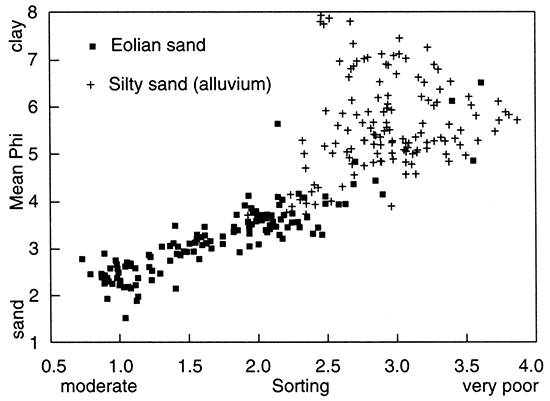
According to Arbogast and Johnson (1998), sedimentological data verify that dune sand resulted from different depositional processes (reflecting the increased aridity of the late Holocene) from those that caused the accumulation of silty-sand alluvium. Specifically, the sedimentological variables that best distinguish silty-sand alluvium from dune sand are mean particle size and sorting; when these variables are plotted with regard to one another, distinguishable populations result. Mean particle size in silty-sand alluvium is coarse to fine silt, indicating the high percentages of silt in the deposit. In contrast, average texture in dunes ranges from coarse silt to very fine sand. Dune sand is moderately to poorly sorted, with a near linear relationship to mean texture. Conversely, silty-sand alluvium is poorly to very poorly sorted with a much poorer relationship to texture than dune sand. According to Friedman (1967), eolian sands are better sorted because they are transported largely by saltation. Given the clear difference between the two deposits (fig. 63), Arbogast and Johnson (1998) concluded that each deposit resulted from diachronous processes, with silty sand resulting largely from alluviation and dune sand accumulating in an eolian environment.
Figure 63--Scatterplot of mean phi and sorting in the silty sand and dune sand (modified from Arbogast and Johnson, 1998).
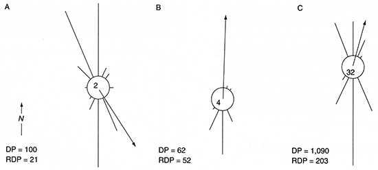
The orientation of dune limbs is a good indicator of prevailing paleowinds. On the Great Bend Sand Prairie, most parabolic dune fields have limbs that are largely oriented southwesterly (fig. 64), though some dunes are oriented northwesterly. Wind data from Hutchinson, Kansas, immediately to the east of the Great Bend Sand Prairie, illustrate the probable cause for dune orientation. During the winter months prevailing winds are northwesterly (fig. 65A), whereas in the summer they are southerly to southwesterly (fig. 65B). When annual data are summarized, the region can be characterized as a high-energy environment with multidirectional winds; drift potential (DP), the relative sand-moving capability of wind, is 1,090. Because summer winds are strongest, the resultant drift direction (RDD) is northeasterly overall (fig. 65C; D. R. Muhs, personal communication, 1995; Arbogast, 1996b). Given the orientation of most parabolic dunes, summer winds are considered to be largely responsible for dune migration. Northwesterly oriented dunes indicate that mobilization of sand has also occurred during the winter.
Figure 64--Aerial photograph of a parabolic dune field in secs. 8, 9, T. 23 S., R. 17 W. The Arkansas River is in the northwest corner. Note the well defined, crescentic-shaped dunes in the left portion of the photograph. Bright spots are blowouts where sand is locally active. Distance across the photograph is approximately 3.2 km (2 mi).
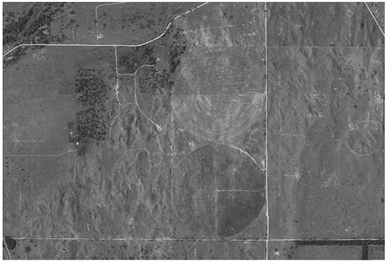
Figure 65--(A) February sand-rose diagram (complex) from Hutchinson, Kansas. Winds are multidirectional, with the prevailing wind from the northwest and a southeasterly resultant drift direction (RDD; from D. R. Muhs, personal communication, 1995; Arbogast, 1996a). Drift potential (DP) measures (in vector units) the relative sand moving capability of wind, whereas the RDP quantifies the resultant drift potential. The reduction factor is the number by which the vector-unit total of each sand-rose arm was divided so the longest arm would plot at <50 mm. Here, it is 2 (Fryberger and Dean, 1979). (B) July sand-rose diagram (wide unimodal) for Hutchinson. Winds are dominantly southerly with a north to northeasterly RDD. Here, the reduction factor is 4. (C) Annual summary of sand-rose diagrams (complex for Hutchinson). In this diagram, the reduction factor is 32.
Evidence for regional landscape instability about 1,000 yr B.P., potentially resulting from increased dryness (Hall, 1982), is well documented throughout the central Great Plains. For example, following a period of stability at approximately 1,200 yr B.P., streams throughout the region entrenched dramatically (e.g., Johnson and Martin, 1987; Johnson and Logan, 1990; May, 1992; Arbogast and Johnson, 1994). Significant mobilization and deposition of eolian sand since 1,000 yr B.P. is documented at five widely scattered sites on the Great Bend Sand Prairie. At the Crocket Cutbank, a maximum-limiting age of around 900 yr B.P. was derived from a buried soil underlying approximately 6 m (20 ft) of dune sand. Similarly, buried soils in dune sand at Reno 3 and Reno 4 dated to about 700 yr B.P. At the Rice Roadcut, ages of around 500 yr B.P. and 400 yr B.P. were obtained from the bottom and top, respectively, of a buried soil in dune sand. At Stafford 6, two periods of soil formation apparently occurred in the past 600 years. Two ages were obtained from the lowermost soil buried at the site: approximately 600 yr B.P. and 500 yr B.P. from the bottom and top, respectively. Following deposition of about 60 cm (24 in) of eolian sand, a brief period of soil formation occurred around 300 yr B.P.
According to Arbogast (1996b), radiocarbon dating of buried soils in late Holocene dune sand conservatively suggests that four distinct periods of soil formation are preserved: around 2,300, 1,400, 1,000, and from 700 to 200 yr B.P. When the two buried soils from Stafford 6 are included, the record is even better resolved because they provided distinct ages of about 540 and 300 yr B.P,. As a result, Arbogast (1996b) concluded that at least five periods of late-Holocene soil formation, generally bracketing intervals of eolian sand mobilization, are preserved in dunes of the Great Bend Sand Prairie at approximately 2,300, 1,400, 1,100 to 900, 700 to 500, and 300 calibrated yr B.P.
Results from this study compare favorably with other findings derived from the central Great Plains in the past ten years. Late Holocene dune formation has been reported throughout the region (e.g., Ahlbrandt et al., 1983; Forman and Maat, 1990; Forman et al., 1995; Madole, 1986, 1994, 1995; Muhs, 1985; Ponte et al., 1994; Muhs et al., 1996), with significant reactivation of dunes in both northeastern Colorado and the Great Bend Sand Prairie in past 1,500 years. Mobilization of eolian sand in the Colorado piedmont and Kansas was apparently episodic. According to Arbogast (1996b), periods of stability and soil formation may have occurred regionally in dunes at approximately 1,400 yr B.P. and 900 yr B.P. Arbogast (1996b) demonstrated, however, that stability has transpired more frequently in the past few hundred years in south-central Kansas because soils dated at about 700-500 yr B.P. and 300 yr B.P. on the Great Bend Sand Prairie have not yet been recognized in northeastern Colorado. This is consistent with the current, more arid conditions in northeastern Colorado, which receives less than 40 cm (16 in) of precipitation annually (NOAA, 1982), as opposed to the Great Bend Sand Prairie, which gets about 75 cm (30 in) of precipitation a year.
Although dunes have mobilized in the late Holocene on the Great Bend Sand Prairie, instability has differed spatially. Surface soil development varies in many dune fields, including sola with A/Bt/C or A/AC/C horizonation, providing an indirect measure of the spatial deviation in dune stability. Calibrated radiocarbon ages from the top and bottom of buried soils at the Rice Roadcut and Stafford 6 suggest that soils with A/AC/C profiles formed within a 300-year period. As a result, many dunes (e.g., Crocket Cutbank, Cullison Quarry) have been stable for a relatively brief period of time. In contrast, dunes with A/Bt/C horizonation in their surface soils must have been stable for a longer period of time (e.g., Birkeland, 1984). These findings are consistent with accounts of early 19thcentury explorers, reported by Muhs and Holliday (1995), who noted both active and inactive dunes along the Arkansas River valley.
There is also direct evidence that instability in dunes varies spatially in the study area. At the Buster Quarry, for example, a "modern" age was derived from a soil buried by 80 cm (31 in) of stabilized dune sand. Barbed wire was found overlying a buried soil in a dune at the Cullison QUarry. Blowouts are commonly occurring features in many dune fields, contributing to the "chaotic" appearance defined by Smith (1940) and indicating that many dune fields are presently near the threshold for instability (e.g., Muhs and Maat, 1993).
Contributions of This Study
This study has added to the chronology of late Quaternary landform evolution and climate change in the central Great Plains in several respects. Although preliminary research (Johnson, 1991; Feng, 1991) characterized the silty sand as Peoria loess, this study illustrates that the unit is dominantly fluvial in nature, with several facies that may have accumulated in a marshy environment of interconnected lakes. Another result of this study is the recognition that the Brady soil, previously identified only in loess and alluvium, also occurs in dunes (e.g., Wilson Ridge). Prior to this study, lunettes (e.g., Wilson Ridge) were not recognized north of the southern High Plains. In addition, the orientation of Wilson Ridge indicates that northwesterly winds prevailed as far south as Kansas during the late Wisconsinan. This study also demonstrates that the Bignell loess, previously thought to exist only in small, discontinuous areas, may be present in a relatively broad expanse in the loess plain north of Stafford on the Great Bend Sand Prairie. Another result of the study is the recognition that most dunes in the Great Bend region are younger than was previously thought. Early researchers (e.g., Smith, 1940; Simonett, 1960) of eolian sand mobilization along the Arkansas River assumed, without absolute age control, that dunes were late Wisconsinan landforms because they were on the southern side of the river (i.e., northwesterly winds produced the dunes). Although late Wisconsinan eolian sand deposits do occur (e.g., Wilson Ridge), results from this study demonstrate that most dunes in the Great Bend region are very young landforms with significant activation in the last 1,000 years due to prevailing southwesterly winds. Finally, the study demonstrates that surface soils in dunes, consisting of A/AC/C profiles, form in 200 to 300 years.
The record of late Holocene eolian sand stability and mobilization on the Great Bend Sand Prairie is especially significant in the context of greenhouse warming scenarios. Intuitively, it would appear that a dramatic shift toward a more arid climate must occur for dunes in the region to become mobilized in a widespread fashion. Although droughts have occurred periodically (e.g., 1890's, 1930's, 1950's) since climate data have been compiled for the area, they have not been severe enough to promote extensive eolian sand mobilization. On the contrary, these and other results (e.g., Madole, 1994) recently derived from the central Great Plains document intensive dune formation in the past 1,000 years, even though atmospheric circulation models indicate little variation in average surface temperature and annual precipitation during the last millenium (Kutzbach, 1987). Muhs and Maat (1993) predicted that dunes in the Great Plains could increase one activity class (e.g., inactive to active crests), using Lancaster's (1988) dune mobility index, assuming a 4°C increase in temperature as per many GCM's (Hansen et al., 1988; Wetherald and Manabe, 1988; Wendland, 1993). This study verifies the climatic sensitivity of dunes and sand sheets of the central Great Plains, indicating that the threshold for soil stability can be crossed much more easily than once thought (e.g., Smith, 1940; Simonett, 1960). These results are especially significant for land-use planning in the region if the levels of projected greenhouse warming and drying actually occur.
Future Research
Much remains to be done in the Great Bend Sand Prairie before a comprehensive model of late Quaternary landscape evolution can emerge. Specifically, future study in the region should focus on the origin and post-depositional alteration of the silty sand, and the construction of a detailed chronology of late Holocene eolian sand mobilization.
Although intensive sampling and textural analyses of the silty sand were conducted in this study, the precise mode of sedimentation remains unclear. Sedimentological evidence (e.g., sorting, fining-upward sequences, spatial variability in texture) suggests deposition in a very low energy fluvial environment of some kind during the late Wisconsinan. Paleomeanders along the Arkansas River west of Great Bend indicate that discharge was much higher during the late Wisconsinan (Johnson, 1988) and may have maintained a network of playas (e.g., Wilson Ridge) or shallow lakes on the Great Bend Sand Prairie that were interconnected by distributary streams. Given widespread deposition of Peoria loess in the area surrounding Great Bend at the same time, however, eolian silt sedimentation must have occurred in the silty sand as well. Future research should attempt to quantify the relative input of fluvial and eolian processes in this widespread, late Wisconsinan unit. In addition, an attempt should be made to clarify the history of stability, soil formation, and weathering in the unit. In particular, it would be useful to determine whether the well-developed soils in the silty sand formed in one extended event or through the episodic burial and exhumation that has apparently occurred because of surficial, mobilizing sand.
Future research should also be conducted to refine the chronology of late Holocene eolian sand mobilization and stability of dunes in the study area. In this study, all radiocarbon ages on buried soils generally estimate when periods of stability occurred, as opposed to dating the interval when deposition of dune sand transpired. In the future, optical simulated luminescence (OSL) dating should be used to establish when eolian sand mobilized. In Wyoming, Stokes and Gaylord (1993) successfully used OSL to refine the chronology of dune instability in the Ferris dune field. At Great Bend, there is an excellent opportunity to enhance the history of eolian sand mobilization through OSL dating at sites such as the Crocket Cutbank, Rice Roadcut, and Stafford 6, where good radiocarbon control on buried solums has been established in this study.
Acknowledgments
This study would have been impossible without funding from national and state-level agencies. At the national level, the research was supported by the National Aeronautics and Space Administration (NASA) Global Climate Change Program (ref. # 1780-GC92-0137) and the Sigma Xi Grants-in-Aid of Research Program. At the state level, funding was provided by the Kansas Geological Survey, Geohydrology Section.
Numerous people have been generous with their time, friendship, and support. Naturally, this project would not have been possible without the cooperation of people in the study area. Sharon Falk of Groundwater Management District 5 provided access to many landowners, including Alan McMillan, Pat Platts, Jim Soden, Harold Smith, and James Crocket, who graciously allowed me to excavate on their property. I am especially grateful to Chad Wilson for tolerating numerous visits, a paleopedology field trip, and much digging at "that weird piece of land" called Wilson Ridge.
Several people aided me in the field. Special thanks goes to Roy Johnson, my backhoe operator, who not only excavated beautiful trenches, but told great stories while I collected samples. His wife, Opal, always sent me some extra tomatoes and plum butter in Roy's lunch. Rick Cox, with the United States Soil Conservation Service, helped me describe soil stratigraphy at many sites. Without my good friends Steve Bozarth and Dave Baumgartner, collecting samples would have been a lot more work.
A variety of people helped me compile and interpret data in the laboratory. Rod Bassler and Steve Yoder of the Kansas Geological Survey provided critical cartographic support and expertise. Bert Rowell, of the Geology Department at The University of Kansas, generously gave his time to photograph landsnails. Analysis of thin sections was conducted with the aid of Mickey Ransom from Kansas State University. I would also like to thank David W. May and Vance T. Holliday for the thoughtful reviews that dramatically improved the quality of this book.
The distinguished members of my Committee also deserve recognition. Paul Enos of the Geology Department at The University of Kansas taught me the fundamentals of sedimentological analyses in a fascinating course. Bob Buddemeier of the Kansas Geological Survey helped immensely in my analyses of radiocarbon data and provided needed funding. Dan Muhs of the United States Geological Survey gave excellent editorial support in addition to aiding my job search. Curt Sorenson has provided invaluable assistance, in many ways, in the years I have known him. Through a series of excellent classes, he taught me nearly everything I know about soils. In addition, he has given much needed support in my grant and job pursuits. Finally, he always challenged me to think beyond my comfort level.
I am especially indebted to Bill Johnson, my advisor. Bill and I have worked together on many projects, and I regard him as a very good friend and mentor. He worked hard, often going to great lengths, to provide support for my endeavors in countless ways. If imitation is the sincerest form of flattery, I hope I give to my students in the same manner that Bill supported me.
Finally, my greatest appreciation goes to my wife, Jennifer. Since we met five years ago, she has faithfully stood behind my efforts and it is impossible to measure her support. She helped me in the field, in the laboratory, and in my writing. She tolerated, with little complaint, my comings and goings and extended trips to the field. In short, without her, this project would have lost its meaning.
Prev Page--Results, Continued || Next Page--References
Kansas Geological Survey, Geology
Placed on web March 16, 2016; originally published 1998.
Comments to webadmin@kgs.ku.edu
The URL for this page is http://www.kgs.ku.edu/Publications/Bulletins/242/05_disc.html