![]()
Prev Page--Previous Research, Methods || Next Page--Results, Continued
Results
Reconnaissance
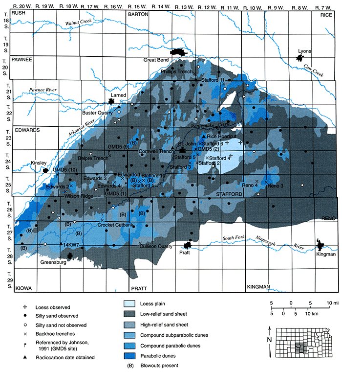
As noted above, coring, bucket augering (or both) occurred at 126 sites in order to ascertain the distribution of the silt-clay/silt layer. Of the 126 sites tested, 95 (75.4%) contained the silt layer, indicating that it is indeed widespread (fig. 6). Over the course of the reconnaissance, however, it was determined that the terms silt-clay layer or silt layer; which imply a single stratum largely composed of silt, are misnomers. In reality, it appears that the deposit, as previously defined (Rosner, 1988; Johnson, 1991), may include several facies, differentiated by color and texture, that intertongue in some fashion. Moreover, the deposit consists largely of sand at most sites, but does contain high, though variable, percentages of silt and clay as compared to the overlying, wind-blown sand. At all localites, well-developed soils with strong structure were recognized in the deposit. Given that a generic term for the unit(s) is useful when referring to site stratigraphy, a new term, silty sand, is proposed to reflect the dominant composition of the deposit. Qualitative results from exploratory testing indicated that the silty sand changes considerably in depth, texture, and color in the study area. At some localites, the unit is buried by several meters of eolian sand, whereas at others, the stratum was exposed at the surface. Texture varies from silty clay loam to sandy clay loam, and color ranges from black (10YR2/1; moist) to an oxidized, strong brown (7.5YR5/6; moist). As anticipated, the silty sand is mottled or gleyed in many places due to reduction.
Mapping
Mapping of surficial deposits was conducted by analyzing aerial photography, county soil surveys, and reconnaissance. Ultimately, a map was produced that recognizes six, primary geomorphic categories in the uplands of the Great Bend Sand Prairie (fig. 6):
- Loess plain, including flat to slightly undulating topography underlain by loess in the area north and east of Stafford.
- Low-relief sand sheet, including landscapes of little or no relief that are mantled by sand.
- High-relief sand sheet, consisting of slightly undulating, irregular sand-mantled topography without steep faces.
- Compound subparabolic dunes, including some elements of category 3, but consisting largely of dune fields displaying traces or remnants of parabolic dune limbs and steep slip faces superimposed on one another.
- Compound parabolic dunes, dune fields that consist largely of superimposed parabolic forms, but may include elements of categories 3, 4, and 6.
- Parabolic dunes, dune fields composed of individual parabolic forms with steep slip faces and welldefined limbs.
Figure 6--Generalized landform classes and study sites on the Great Bend Sand Prairie.
Stratigraphic Investigations
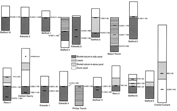
Nineteen sites showing the variability of late Quaternary stratigraphy on the Great Bend Sand Prairie were exposed or accentuated by backhoe trenching and systematically described, sampled, and analyzed according to the methods outlined above. The results of intensive stratigraphic investigations at each of the 19 study sites are summarized below (for details see Arbogast, 1995). Although the top of silty sand serves as a stratigraphic datum because it is generally a traceable surface (fig. 7), unit designations for deposits at each site are unique and do not imply any correlation among or between sites.
Figure 7--Summary stratigraphic diagram from the 18 sites where silty sand and/or loess was investigated on the Great Bend Sand Prairie (modified from Arbogast, 1996b).
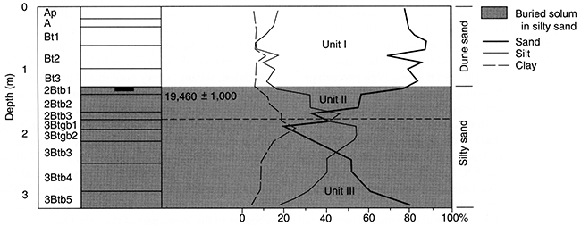
Belpre Trench
The Belpre Trench is a 4.11-m (13.5-ft)-deep section (figs. 7, 8) in a drainage pit excavated on a level sand sheet in the NE NW sec. 8, T. 24 S., R. 15 W. (fig. 6). After the trench wall was cleaned, three pedostratigraphic units were recognized in the exposure (figs. 8, 9). In general, deposits are loamy, moderately to very poorly sorted, finely to very finely skewed, and very leptokurtic to very platykurtic (Arbogast, 1995). Three radiocarbon ages were obtained from the site, indicating a geomorphic history that spans the past 20,000 years.
Figure 8--The 4.11-m (13.5-ft)-deep Belpre trench, showing the position of pedostratigraphic units and radiocarbon ages.
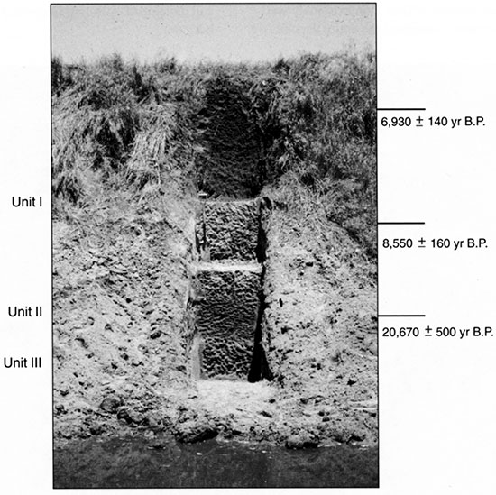
Unit III, the lowest exposed at the site, ranges from 3.74 m (12.3 ft) to at least 4.11 m (13.5 ft), the base of the profile. In general, the deposit consists of relatively well sorted, oxidized, and unconsolidated sand. Because sedimentary structures are not preserved in the stratum, determining a depositional facies is problematic, i.e., the unit could have accumulated in either a fluvial or eolian environment. A brief period of pedogenesis subsequently occurred, resulting in the formation of a moderately developed soil with two 3Bwb horizons (fig. 9).
Figure 9--Pedostratigraphy, soil horizonation, and texture at the Belpre Trench.
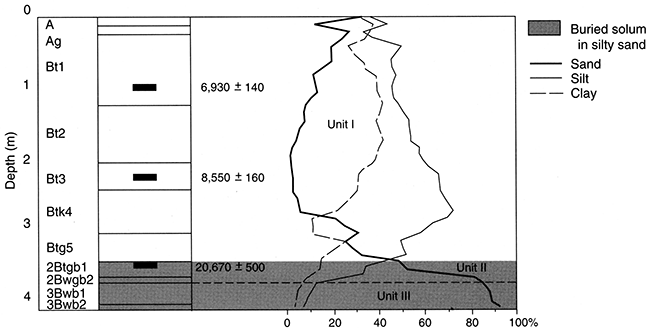
Overlying Unit III is Unit II, which extends from 3.44 m (11.3 ft) to 3.48 m (11.4 ft) (figs. 8, 9). In contrast to Unit III, Unit II consists of much siltier sediments. Although sedimentary structures are not preserved, the deposit is very poorly sorted, suggesting a fluvial facies in a presumably more moist environment than at present. Following deposition, a period of pedogenesis occurred, one that promoted the formation of a well-developed soil with two 2Btgb horizons (fig. 9). The upper part of the solum dated to approximately 20,000 yr B.P., suggesting a Farmdalian, or perhaps Woodfordian age for both Units III and II. A δ13C value of -22.3 implies that a mixture of plants with C3 and C4 pathways dominated at the site during that time. The soil is mottled, with pockets of gleying and iron oxidation present, which suggests ponding during some unknown interval of time or, alternatively, a periodically high water table.
The dominant pedostratigraphic unit at the Belpre Trench is Unit I, extending from the surface to 3.44 m (11.3 ft) (figs. 8, 9). Although the deposit is largely composed of silt (72.6%), high percentages of clay are also present, especially in the upper part (41.9% at 1.30 m; 4.3 ft) of the stratum (fig. 9). Sedimentary structures are not preserved in the unit, so depositional facies can not be determined with certainty. In fact, conflicting evidence exists regarding both the sedimentary process responsible for the unit and its age.
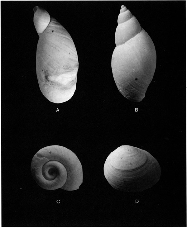
The color of the lower part (2.06-3.44 m; 6.8-11.3 ft) of Unit I is generally consistent (pale brown; 10YR6/3; moist) with late Wisconsinan Peoria loess (Wells and Stewart, 1987; Johnson, 1993; Johnson et al., 1993), which has been recognized immediately to the north and south of the Great Bend Sand Prairie (Feng, 1991; Feng et al., 1994). Moreover, abundant late Wisconsinan gastropods, including Succinea avara, Lymnaea parva, and Helicodiscus singleyanus (fig. 10) were recovered from the base of the deposit. On first examination, therefore, a Woodfordian age was suggested for deposition of Unit 1. Approximately 20 cm (7.9 ft) above the snail zone, however, a radiocarbon age of approximately 8,500 yr B.P. was obtained, implying a very early Holocene age for the deposit. Apparently, the sample that was dated must have been contaminated in some way, possibly by Holocene organic carbon illuviated during the extensive soil development which has occurred. Given the age (about 20,000 yr B.P.) derived from the top of Unit II, the presence of gastropods, and the similarity with Peoria loess, a Woodfordian age for the lower part of Unit I is more logical.
Figure 10--Mollusks recovered from the Belpre Trench (magnification x10): (A) Succinea avara, (B) Lymnea parva, (C) Helicodiscus syngleyanus, (D) unidentified bivalve.
In addition, an age of about 17,000 yr B.P. was obtained by Johnson (1991) from spruce (Picea cf. glauca) charcoal in a similar stratigraphic position at GMD 5, site 9, approximately 0.5 km (0.2 mi) to the northwest, further suggesting a Woodfordian age for Unit I. A δ13C value of -2l.0‰ derived from the deposit, coupled with the oxidized nature and presence of aquatic gastropods in the lower part of the unit, indicates relatively moist conditions during sedimentation.
Following deposition of Unit I, an extremely well developed soil formed throughout the entire deposit (fig. 9). Structure is very strong in the solum, especially in the upper 1.50 m (4.9 ft), where it is coarse prismatic, parting to moderate blocky. Overall, the character of the soil suggests pedogenesis over an extended interval of time, perhaps throughout the late Holocene. In fact, the upper part of the Btl horizon, approximately 1.0 m (3 ft) below the surface, dated to approximately 6,000 yr B.P. A δ13C value of -20.2‰ suggests plants with a C3 pathway were present at that time. Apparently, water has ponded periodically at the site as the soil developed, resulting in gleying of the lower part of the A horizon.
Crocket Cutbank
The Crocket Cutbank is an 8-m (26-ft)-high section (figs. 7, 11) located in a compound subparabolic dune field along a cutbank of Rattlesnake Creek in the SE SE sec. 35, T. 26 S., R. 17 W. (fig. 6). Through backhoe trenching, the overall height of the exposure was increased to 9.8 m (32.2 ft). Four pedostratigraphic units were described in the profile, with two weakly developed and narrowly separated buried soils featured in the exposure (figs. 11, 12). Sediments at the site are generally noncalcareous, sandy (with a mean particle size of fine to very fine sand), poorly to moderately sorted, finely to very finely skewed, and mesokurtic to extremely leptokurtic (Arbogast, 1995).
Figure 11--The 9.8-m (32.2-ft)-high Crocket Cutbank showing the position of pedostratigraphic units and radiocarbon ages.
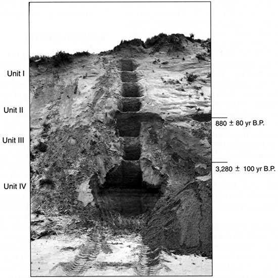
Figure 12--Pedostratigraphy, soil horizonation, and texture at the Crocket Cutbank.
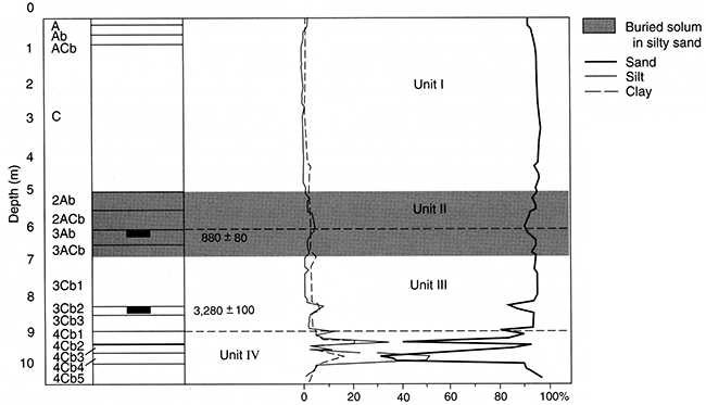
The lowermost deposit is Unit IV; it extends from 8.76 m (28.7 ft) to the base of the profile and is a stratified alluvial deposit probably associated with Rattlesnake Creek. Although no radicarbon ages were obtained from the unit, the lack of cementation and the floodplain position relative to Rattlesnake Creek suggest a late Holocene age.
Directly overlying this unit is Unit III, which extends from 5.88 m to 8.76 m (19.3-28.7 ft). The lower part of Unit III appears to be transitional from alluvial to eolian sedimentation at the site. A radiocarbon age of approximately 3,300 yr B.P. was obtained from a silty deposit that extends from 8.06 m to 8.23 m (26.4-27.0 ft). A δ13C value of -17.7‰ suggests that the site was largely populated by plants with a C4 pathway. Given its close proximity, Rattlesnake Creek is believed to be the primary source for both floodplain and eolian facies in the unit.
The upper part of Unit III is entirely eolian, as indicated by its consistent sandy texture and moderate sorting. Formed in the upper part of the unit is a weakly developed buried soil, one that consists of a 3Ab horizon overlying a 3ACb horizon (fig. 12). The degree of development in this soil indicates that landscape stability and accompanying soil formation was relatively brief. A radiocarbon age of approximately 900 yr B.P. on humates from the upper 5 cm (2 in) of the soil provides a late Holocene age for the host eolian sand. A δ13C value of -16.6‰ suggests that plants with a C4 pathway dominated at the site.
Unit II consists of a nearly 1-m (3-ft)-thick deposit of eolian sand (figs. 11, 12) that contains a weakly developed buried soil with a 2Ab horizon and a 2ACb horizon. Virtually identical to the buried soil at the top of Unit III (fig. 12), the soil in Unit II reflects another, brief period of landscape stability that occurred sometime after approximately 900 yr B.P. Despite their close proximity, it is unclear what the exact temporal relationship is between the two soils. Theoretically, deposition of Unit II, and subsequent soil formation, could have occurred shortly after the period of stability reflected by the 3Ab. Given this scenario, sedimentation of Unit II suggests a very brief depositional episode, one that exceeded pedogenic thresholds in the 3Ab. Conversely, deposition of Unit II and development of the 2Ab could have transpired after truncation of an older deposit that had previously buried the 3Ab. Although no radiocarbon age was obtained from the 2Ab to estimate the age of the host sand, the lack of any visible unconformities between Unit III and II suggests that Unit II sedimentation, followed by formation of the 2Ab, occurred soon after the 3Ab developed.
The uppermost stratigraphic unit at the Crocket Cutbank, Unit I, consists of a 4.91-m (16.1-ft)-thick deposit of eolian sand that extends from the surface to the top of Unit II (figs. 11, 12). Sedimentological data indicate that the unit is remarkably consistent in character, including deposits that are moderately sorted and as much as 97% sand (fig. 12). This evidence, coupled with the lack of any visibile unconformities, suggests that eolian sedimentation at the site has been relatively consistent in the past few hundred years. Given the availability of fluvial sediments, Rattlesnake Creek may have been the primary source for eolian sands at the site. Recently, a poorly developed surface soil (A/AC/C horizonation) has formed, one that is consistent in its development with the buried soils recognized in Units II and III. This indicates that the dune had been stable for a brief period of time, perhaps less than 500 years.
Cullison Quarry
The Cullison Quarry is a 5.95 m (19.5 ft) section (figs. 7, 13) exposed in a quarry located in a high-relief sand sheet in the NE SW sec. 34., T. 27 S., R. 15 W. (fig. 6). Four pedostratigraphic units were recognized in the profile, with the lower pair consisting of silty sand and the upper two of dune sand (figs. 13, 14). In general, units are loamy to sandy, very poorly to moderately sorted, very finely to finely skewed, and platykurtic to very leptokurtic (Arbogast, 1995).
Figure 13--The 5.95-m (19.5-ft)-high Cullison Quarry, showing the position of pedostratigraphic units and radiocarbon ages.
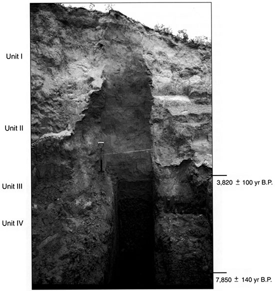
Figure 14--Pedostratigraphy, soil horizonation, and texture at the Cullison Quarry.
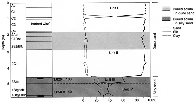
Extending from 4.70 m (15.4 ft) to the base of the profile are Units IV and III (figs. 13, 14), which contain relatively high percentages of silt and clay. Unit IV, in particular, has as much as 46.0% silt and 26.5% clay. Although sedimentary structures were not observed in either unit, sorting is very poor, suggesting a fluvial facies. Following deposition of each deposit, a period of landscape stability and soil formation occurred, resulting in well-developed soils. Pedogenesis was especially intense in Unit IV, promoting development of two 4Btgssb horizons (fig. 14) with strong, prismatic structures. A radiocarbon age of approximately 7,900 yr B.P. derived from the 4Btgssbl horizon suggests that Unit IV accumulated between the very late Wisconsinan or early Holocene. A δ13C value of -20.0‰ indicates a mixture of plants with C3 and C4 pathways inhabited the site. Water tables must have been periodically high, for in addition to the relatively high percentage (5.2%) of carbonate in the 4Btkgssb2 horizon, all of Unit IV is heavily gleyed.
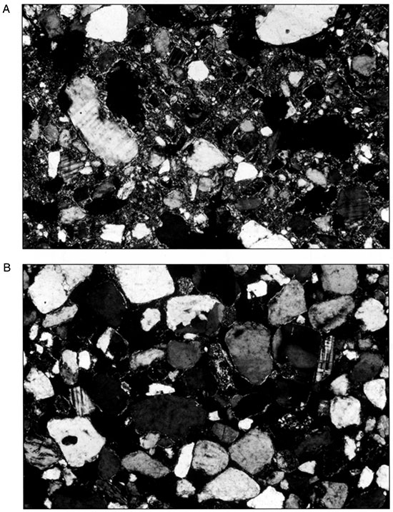
At some point, an interval of erosion apparently occurred, one that removed a theorized 4Ab. The sandier sediments of Unit III were subsequently deposited and a soil again formed. The original thickness of Unit III is unknown, because only one 3Btb horizon remains. The matrix of the 3Btb horizon, seen in thin section, consists of a skeleton fabric and a fine-textured plasma and mineralogy that is dominated by quartz, with occasional feldspars and rock fragments (fig. 15A). Striations are apparent in the birefringent material that separates sand grains, indicating illuviation of clay. In addition, illuvial clay lines the internal wall of voids in many places, providing further evidence of clay translocation. Many of the clays are twisted, suggesting their expansion and contraction through time.
Figure 15--Thin sections (FOV = 1.85 x 2.69 mm) of the (A) 3Btb1 and (B) 2Ab horizons at the Cullison Quarry (from Arbogast and Johnson, in press).
A radiocarbon age of about 3,800 yr B.P. from the upper part of Unit III suggests final exposure during the late Holocene when higher temperatures and probably less effective moisture prevailed, as indicated by a δ13C value of -14.8‰. In short, the character of Units IV and III, coupled with the ages derived from them, are generally consistent with other deposits (e.g., Edwards 1-3, Stafford 3, Reno 4, for which descriptions follow) categorized as silty sand on the Great Bend Sand Prairie.
Unconformably overlying the silty sand are a pair of units, Units II and I, that are consistent in texture, structure, color, and topographic position and expression with deposits categorized as dune sand in the region. Each unit represents a period of sand accumulation, presumably during a more arid climate interval, followed by relative stability and soil formation when more effective moisture was present. A radiocarbon age of approximately 3,800 yr B.P. from the top of Unit III (figs. 13, 14) suggests that Units II and I are late Holocene deposits. Although the 2Ab was not dated, its position and degree of development (fig. 14) is consistent with buried sola in the region (e.g., Crocket Cutbank, Reno 3, Reno 4), from which ages less than 1,000 years have been derived. The matrix of the soil, seen in thin section, further indicates very little development because it consists largely of skeleton grains that lack plasma. Mineralogy is dominated by quartz with scattered grains of feldspar and miscellaneous rock fragments (fig. 15B). In contrast to the thin section of the 3Btb1 horizon (fig. 15A), the 2Ab shows very little indication of postdepositional alteration. Some sand grains are coated with birefringent material, probably clay, that may reflect illuviation, but this material may have also been present on the grain as it was transported. Either way, very little clay translocation has occurred relative to the 3Btb1 (fig. 15B).
Overlying Unit II is Unit I (figs. 13, 14), which, as indicated by a small piece of barbed wire recovered from the center of the deposit, is probably less than 200 years old. A weakly developed surface soil, consisting of an Ap horizon and C horizons, coupled with the barbed wire found beneath it (fig. 14), strongly implies that the dune has been stable for a very brief period of time, probably around 200 years.
Edwards 1
Edwards 1 is a 3.30-m (10.8-ft)-deep section (figs. 7, 16), exposed by backhoe trenching, located in a compound subparabolic dune field in the SW NE sec. 11, T. 25 S., R. 16 W. (fig. 6). Three pedostratigraphic units-consisting of a basal silty sand, an intermediate stratum of sandier sediments, and a surficial eolian deposit-were described (figs. 16, 17). In each of the lower two units, a well-developed buried soil was recognized, but none was. observed in the overlying eolian sand (fig. 17). Sediments in the silty sand are noncalcareous, loamy, very poorly sorted, very finely to finely skewed, and mesokurtic to very leptokurtic. Overlying eolian deposits are noncalcareous, very sandy, poorly sorted, very finely to finely skewed, and very leptokurtic to leptokurtic (Arbogast, 1995).
Figure 16--The 3.3-m (10.8-ft)-high exposure at Edwards 1, showing the position of pedostratigraphic units and radiocarbon ages.
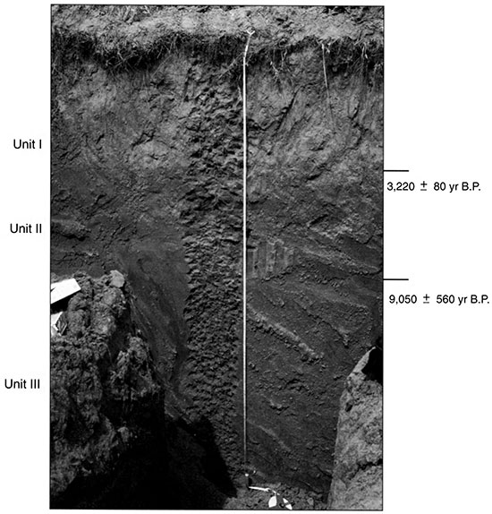
Figure 17--Pedostratigraphy, soil horizonation, and texture at Edwards 1.
At the base of the profile is Unit III, which contains a consistently high percentage of silt (about 60%) and clay (about 25%) and is very poorly sorted, suggesting that it accumulated in a low-energy environment, possibly fluvial or lacustrine. Contained within the unit is an extremely well developed buried soil, consisting of stacked Btb horizons (fig. 17) indicating that the surface was exposed for long periods of time. The lowermost horizon is gleyed, resulting from periodically high water tables or long-term infiltration of water from the surface. A radicarbon age of about 9,000 yr B.P. from humates in the upper 5 cm (2 in) of the 3Btb1 suggests that the underlying deposits are late Wisconsinan or very early Holocene in age. A δ13C value of -22.2‰ indicates the prevalence of C3 plants, further suggesting a relatively cool environment with probably more effective moisture.
Unit II, which is approximately 50 cm (20 in) thick, is the intermediate deposit at Edwards 1 (figs. 16, 17). The contact between Units III and II is a major unconformity, as suggested by the lack of an Ab horizon in Unit III and a late Holocene age of about 3,200 yr B.P. taken from the top of Unit II. Unit II is much coarser than the underlying deposit, indicating that some change in depositional environment occurred at the site. The increase in sand in Unit II, coupled with an apparent late Holocene age, favors eolian deposition. No change in sorting can be discerned from the underlying strata, however, as relatively high percentages of silt and clay (about 20% and 15%, respectively) persist (fig. 17). Theoretically, Unit II could have accumulated when the surface occupied an interdune position on the landscape, and a combination of eolian and alluvial processes might have contributed to sedimentation. The unit must have been exposed periodically and for some time, as indicated by the strong soil that developed throughout the unit. A radiocarbon age of about 3,200 yrs B.P. (figs. 7, 16, 17) suggests that the last exposure of Unit II was during the late Holocene. There were apparently less effective moisture and warmer temperatures than during the Early Holocene, as implied by a δ13C value of -13.2‰ from the upper part of the stratum.
The uppermost pedostratigraphic unit at Edwards 1 is Unit I (figs. 16, 17). Illustrated on fig. 17 by a sharp textural contact, the deposit consists of an approximately 1.1O-m (3.6-ft)-thick deposit of sand that is consistent in texture, color, and topographic position and expression with other deposits in the region identified as dune sand. Following a period of erosion that removed the Ab from the upper part of Unit II, Unit I apparently accumulated during the late Holocene. Although it is unclear when that occurred, two pieces of evidence suggest that the surface of the site has been stable for a relatively long period of time: the degree of surface soil development (including a Bw and two Bt horizons with lamelli) and oxidation in the Bt2 horizon. Given this evidence, especially the extent of surface soil development, it is estimated that Edwards I has been relatively stable for at least 1,000 years.
Edwards 2
Edwards 2 is a 3.15-m (10.3-ft)-deep section (figs. 7, 18), exposed by backhoe trenching, located in a compound parabolic dune field in the SE NW sec. 22, T. 26 S., R. 18 W. (fig. 6). Three pedostratigraphic units were described, with two consisting of silty sand and one of surficial, eolian sand (figs. 18, 19). In general, sediments are noncalcareous, loamy, very poorly to poorly sorted, finely to very finely skewed, very leptokurtic to platykurtic, and have a mean particle size of fine to coarse silt (Arbogast, 1995).
Figure 18--The 3.15-M (10.3-ft)-high exposure at Edwards 2, showing the position of pedostratigraphic units and radiocarbon ages.
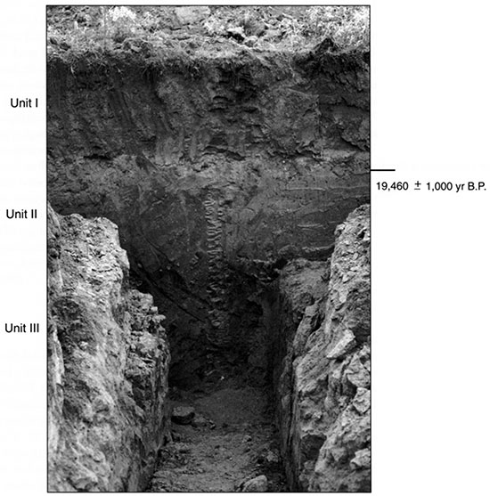
Figure 19--Pedostratigraphy, soil horizonation, and texture at Edwards 2.
Unit III extends from 1.78 m (5.8 ft) to the base of the profile (figs. 18, 19). Texture fines sharply from loamy fine sand at the base to loam at the top (fig. 19). Deposits in the lower part are consistent in texture and distribution with surficial wind-blown sands, suggesting an eolian facies. The heavy texture and very poor sorting of the upper portion of Unit III, however, indicates a shift in depositional environment to some form of low-energy fluvial process. Mottling and gleying in the unit indicate periodically high water tables or long-term ponding.
Unit II is characterized by its color (7.5YR4/4; moist), which suggests oxidation, and by a coarsening in texture toward the top of the unit (figs. 18, 19). At the base of Unit II, the sediment is loam, but the percentage of sand increases sharply (77%) at the top of the unit (fig. 19). Sorting is very poor from bottom to top. A radiocarbon age of about 19,000 yr B.P. and a δ13C value of -19.8‰, taken from the upper part of the unit, indicate that underlying deposits, including all of Units III and II, accumulated by the early late Wisconsinan at a time when C3 plants were abundant at the site.
Although sedimentological evidence in Units III and II generally points to alluvial sedimentation, the degree of soil formation observed in each unit indicates that stable surfaces existed for some time at the site. During intervals of soil formation, intense illuviation occurred that leached carbonate from the lower part of the deposit, and may have contributed to mottling and gleying of Unit III. The lack of buried A horizons suggests that, following stability, erosion occurred, truncating the upper part of the soil. In many places, clay skins can be traced from the top of Unit II to the base of Unit III, indicating that the soils are now welded.
A sharp contact at 1.23 m (4.0 ft) separates the underlying deposits of Units III and II from the surficial, sandy sediments of Unit I (figs. 18, 19). Containing as much as 88% sand (fig. 19), Unit I is consistent in character (e.g., texture, structure, color, topographic position and expression) with other eolian units observed on the Great Bend Sand Prairie that accumulated in a warm, relatively dry environment. Uncharacteristically, the deposit is very poor to poorly sorted, owing to the relatively large percentage of silt (17%) and clay (11%). Theoretically, Unit I may represent both fluvial and eolian facies. The sharp decrease in sorting at 82 cm (32 in), for example, may reflect alluvial deposition in an interdunal environment, with subsequent burial by eolian sand. Alternatively, the local source for Unit I may have contained abundant silt and clay as well as sand.
Evidence indicates that the surface soil has been stable for a relatively long period of time, at least for a deposit of eolian sand on the Great Bend Sand Prairie. Three Bt horizons (fig. 19) were described on the basis of clay films that lined root traces, indicating an extended period of soil formation for a dune in the study area. Most importantly, a radiocarbon age of approximately 19,000 yr B.P. obtained from the top of Unit II (figs. 7, 18, 19) provides a maximum-limiting, late Wisconsinan age for the base of Unit I. Although truncation of a part of Unit I may have occurred during the Holocene, it is apparent that the basal, eolian deposits in the unit are of late Wisconsinan age. Overall, the evidence suggests that the dune at Edwards 2 has been stable for a relatively long period of time.
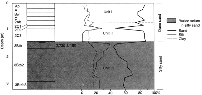
Edwards 3
Edwards 3 is a 3.3-m (10.8-ft)-deep section (figs. 7, 20) exposed by backhoe trenching on a level sand sheet in the NW NW sec. 17, T. 25 S., R. 16 W. (fig. 6). Four pedostratigraphic units were described, with three consisting of silty sand and one of surficial, eolian sand (figs. 20, 21). In general, deposits are noncalcareous, loamy, with a mean particle size of very fine to coarse silt, are very poorly sorted, finely to very finely skewed, and platykurtic to very leptokurtic (Arbogast, 1995). The sedimentological difference between the silty sand and the overlying sand probably represents a change in depositional environment from low-energy fluvial or lacustrine to eolian.
Figure 20--The 3.3-m (10.8-ft)-high exposure at Edwards 3, showing the position of pedostratigraphic units and radiocarbon ages.

Figure 21-Pedostratigraphy, soil horizonation, and texture at Edwards 3. The radiocarbon ages are inverted, which may have resulted from slight contamination of one or both of the samples. Taken together, however, they verify a late Wisconsinan age for the silty sand at this site.
From 30 cm (12 in) to the base of the profile, the deposits consist of silty sand. Three, distinguishable fining-upward sequences were observed, with each comprising a single pedostratigraphic unit. At the base of the exposure, Unit IV fines from loam at the base to clay-loam at the top of the unit. In the lower part of Unit III, the texture coarsens to sandy clay-loam, with a subsequent fining to clay-loam towards the top of Unit III. In Unit II, the sediment fines dramatically, culminating in 42% clay and 7% sand in the upper part of the unit. The fining-upward sequences, coupled with the very high percentage of clay and very poor sorting, strongly suggest deposition in a fluvial environment where energy fluctuated from relatively high to very low. Although radiocarbon ages from the middle and base of the deposit are inverted, they generally suggest that deposits accumulated during the late Wisconsinan. Values of δ13C from the silty sands range from -25.6‰ to -24.7‰, indicating that a proportionately high number of C3 plants inhabited the site.
Although the sedimentological evidence favors fluvial deposition, the formation of three, well-developed buried soils in the silty sand indicates that stable surfaces existed for long periods of time. Each soil consists of stacked Btb horizons with no Ab (fig. 21), suggesting that stability was followed by an erosional episode that truncated the upper part of the solum. In many instances, clay skins can be traced from the top of Unit II to the bottom of the profile, indicating that the soils are now welded.
A sharp contact at 30 cm (12 in) separates the underlying silty sands from the surficial sediments of Unit I (figs. 20,21). Composed largely of sand, Unit I is consistent in texture, structure, and color with dune sand, deposits that accumulated in a relatively warm, arid environment. Uncharacteristically, the sediment in Unit I is very poorly sorted, owing to the high percentages of silt (ca. 10%) and clay (ca. 10%; fig. 21). Although a precise determination of facies can not be made, because of conflicting evidence, it may have resulted from eolian input of different intensities. Theoretically, the sand could have accumulated initially, followed by a subsequent and infiltrating input of silt and clay. Alternatively, the local source for Unit I may have contained a high percentage of silt and clay that was reworked. The moderate development of the surface soil suggests that deposition of Unit I occurred during the late Holocene, probably in the past 1,000 years.
Edwards 4
Edwards 4 is a 3.31-m (10.9-ft)-deep section (figs. 7, 22) exposed by backhoe trenching in a compound subparabolic dune field in the SW NE sec. 16, T. 25 S., R. 16 W. (fig. 6). Three pedostratigraphic units, consisting of one in silty sand and two in surficial eolian sand, were described in the profile (figs. 22, 23). The sedimentological difference between the silty sand and the overlying sand may record a shift from a low-energy fluvial or lacustrine environment to one where eolian processes dominated in a time of increased aridity. In general, sediments at the site are noncalcerous, loamy, have a mean particle size of medium to coarse silt, are very poorly to poorly sorted, very finely skewed, and leptokurtic to very leptokurtic in their distribution (Arbogast, 1995).
Figure 22--The 3.31-m (10.9-ft)-high exposure at Edwards 4 showing the position of pedostratigraphic units and radiocarbon age. Pedostratigraphy, soil horizonation, and texture at Edwards 4.
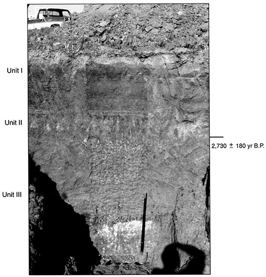
Figure 23--Pedostratigraphy, soil horizonation, and texture at Edwards 4.
The lowermost stratigraphic unit, Unit III, ranges from 1.58 m (5.2 ft) to the base of the profile (fig. 22, 23). Texture within the unit generally fines from loamy fine sand at the base of the exposure to loam towards the top. In addition, sorting is very poor due to high percentages of silt and clay, suggesting a mixed sediment load and accumulation in a very low energy environment. Although Unit III appears to be an alluvial deposit, a stable, exposed surface must have existed periodically, for a buried soil is present that is very well developed (i.e., two 3Btb horizons and one 3Btkb3 horizon; fig. 23). Long-term stability is further indicated by the oxidized color (e.g., 7.5YR4/4; moist), prismatic structure, and intense illuviation of carbonate to the lower part of the unit. Overall, the deposit is consistent with silty sand elsewhere in the region (e.g., Edwards 1 and 2, Stafford 1 and 2), suggesting accumulation during the Woodfordian. The surface of the deposit appears to have been severely truncated, probably by fluvial processes. An age of about 2,300 yr B.P. (figs. 7, 22, 23) from the uppermost 5 cm (2 in) of the unit implies last exposure during the late Holocene. A δ13C value of -17.3‰ suggests the site was inhabited by relatively high percentages of C4 plants.
Overlying Unit III is Unit II, extending from 79 cm to 1.58 m (2.6-5.2 ft) (figs. 22, 23). Classified as loamy fine sand, loam, and fine sandy loam (fig. 23), the deposits in Unit II are consistent in texture, structure, color, and topographic position and expression with other units of eolian sand on the Great Bend Sand Prairie, those that accumulated in a relatively warm, probably more arid environment. The sediments are very poorly sorted, however, suggesting variable wind intensity or a nearby, poorly sorted source. Potentially, sediments in Unit II originated from exposures of the silty sand that were deflated during periods of aridity and high wind. Formed within Unit II is a poorly developed buried soil, consisting of an 11-cm (4.3-in)-thick 2Ab horizon overlying three 2C horizons. The overall lack of structure (e.g., single grain, granular), as compared to that in the underlying silty sand (e.g., prismatic), in the soil further reflects eolian origins. Evidence suggests that Unit II accumulated during the late Holocene. Although a radiocarbon age was not obtained from the 2Ab, the age of the upper 3Btb1 (fig. 23) provides a maximum-limiting age for the deposit. The slightly oxidized color (e.g., 7.5YR3/4; moist) of the 2C horizons suggests a minimum-limiting age of greater than 1,000 years. Apparently, the period of stability was less than 1,000 years, as indicated by the overall lack of development.
Unit I extends from the surface to 79 cm (2.6 ft) (figs. 22, 23). In its sediments (fine sandy loam and sand) and structure (single grain to granular), Unit I is consistent with other deposits of eolian sand observed in the region. Sorting ranges from very poor to poor in the unit, suggesting winds of variable intensity or a nearby, poorly sorted source (e.g. silty sand). Contained within Unit I is a moderately to weakly developed surface soil consisting of two A horizons, a Bw and a C horizon (fig. 23). The character of the soil, coupled with its unoxidized color (10YR3/4; moist), suggests that the site has been stable for 500 to 1,000 years.
Phillips Trench
The Phillips Trench is a 2.7-m (8.9-ft)-deep section (figs. 7, 24) in a drainage pit located in a level sand sheet in the NE NE sec. 25, T. 13 S., R. 20 W. (fig. 6). Three pedostratigraphic units were described, with the lower pair in silty sand and the upper in sand (figs. 24, 25). These units indicate that at least three intervals of rapid sedimentation, interrupted by landscape stability and soil formation, occurred at the site during the late Quaternary. In general, deposits are loamy, very poorly sorted, finely to very finely skewed, and very platykurtic to leptokurtic (Arbogast, 1995).
Figure 24--The 2.7-m (8.9-ft)-deep Phillips Trench, showing the position of pedostratigraphic units and radiocarbon age.
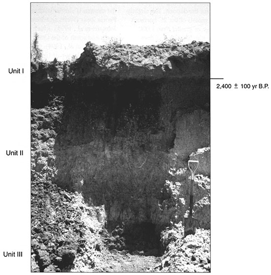
Figure 25--Pedostratigraphy, soil horizonation, and texture at the Phillips Trench.
Unit III is the basal deposit, ranging from about 2.35 m to 2.7 m (7.7-8.9 ft) (figs. 24, 25) and consisting of very poorly sorted, sandy sediments that are rich in silt. The deposit is slightly oxidized, indicating that some wetting and drying occurred following sedimentation. A well-developed soil subsequently formed, consisting of at least two 3Btb horizons (fig. 25). Although a radiocarbon age was not obtained from the soil, the solum is very similar in color, texture, and stratigraphic position with a buried soil recognized at the Belpre Trench that was dated to about 21,000 yr B.P. (figs. 8,9). As a result, Unit III is assigned a late Farmdalian age.
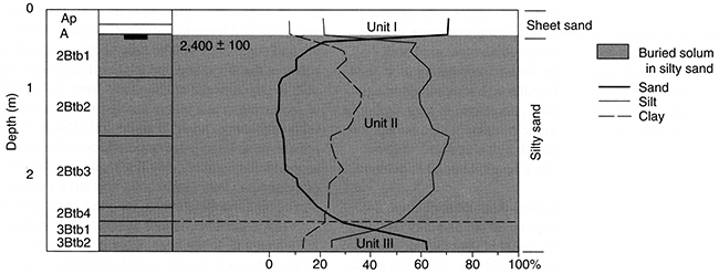
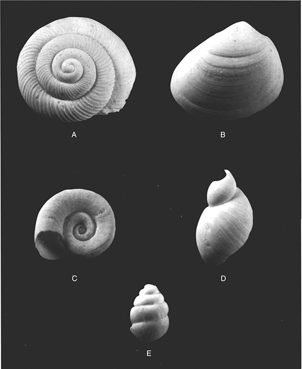
Unit II is a 1.98-cm (6.5-in)-thick deposit (figs. 24, 25), mostly composed of calcareous silt and clay (fig. 25). The lower 58 cm (23 in) of Unit II is slightly oxidized, suggesting periodically moist conditions. Abundant gastropods, the majority of which were fragmented, were also observed at the base of the deposit. A few intact specimens were recovered and identified. The presence of Discus cronkhitei, Helicodiscus singleyanus, Succinea avara, and Vertigo tridentata (fig. 26) provides additional evidence for a cooler environment with probably more effective moisture, possibly during the early Woodfordian. Above this 58-cm (23-in) deposit is a 1.12-m (3.7-ft)-thick deposit of silt and clay that is slightly calcareous. In general, the stratum is similar in character (e.g., color, texture) with Peoria loess (Wells and Stewart, 1987; Johnson, 1993; Johnson et al., 1993), which has been recognized to the north and south of the Great Bend Sand Prairie (Feng, 1991; Feng et al., 1994). Given the late Farmdalian age assigned to the top of Unit III, a Woodfordian age is logical for Unit II. Although no sedimentary structures were observed, the very poorly sorted nature of Unit II, coupled with its loess-like nature, implies deposition by eolian processes. A long period of landscape stability must have subsequently occurred, promoting formation of a very well developed soil. A radiocarbon age of about 2,400 yr B.P. was obtained from the upper 5 cm (2 in) of Unit II, suggesting exposure during the late Holocene.
Figure 26--Mollusks recovered from the Phillips Trench (magnification x10): (A) Discus cronkhitei, (B) unidentified bivalve. (C) Helicodiscus syngleyanus, (D) Succinea avara, (E) Vertigo tridentata.
Overlying Unit II, with an extremely sharp stratigraphic contact, is Unit I (figs 24, 25). Whereas Unit II consists largely of silt and clay, Unit I consists predominantly of sand (fig. 25). Unit I is very poorly sorted, suggesting a nearby source (e.g., silty sand) that had a wide range of textures available for transport. A maximum-limiting age of approximately 2,400 yr B.P., derived from the top of Unit II, indicates that Unit I is a late Holocene deposit. Moreover, a δ13C value of -15.8‰ implies that the climate was warmer and probably drier than when gastropods inhabited the site during the Woodfordian. The surface has been stable for a relatively brief period of time, as indicated by the weak development of the surface soil.
Reno 3
Reno 3 is a 3.24-m (10.6-ft)-deep section (figs. 7, 27) exposed by backhoe trenching in a compound parabolic dune field in the SE SE sec. 12, T. 25 S., R. 10 W. (figs. 6, 27). Four pedostratigraphic units were recognized, one in silty sand and three in sediments predominantly composed of sand (figs. 27, 28). The sedimentological differences between the silty sand and the overlying sand suggest a shift in depositional environment from low-energy alluvial or lacustrine to one where eolian processes dominated in a relatively warm, possibly more arid climate. In general, sediments at Reno 3 are noncalcareous, loamy, very poorly to moderately sorted, very finely to finely skewed, platykurtic to very leptokurtic, and have a mean particle size of medium silt to very fine sand (Arbogast, 1995).
Figure 27--The 3.24-m (10.6-ft)-high exposure at Reno 3, showing the position of pedostratigraphic units and the radiocarbon age.
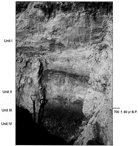
Figure 28--Pedostratigraphy, soil horizonation, and texture at Reno 3.
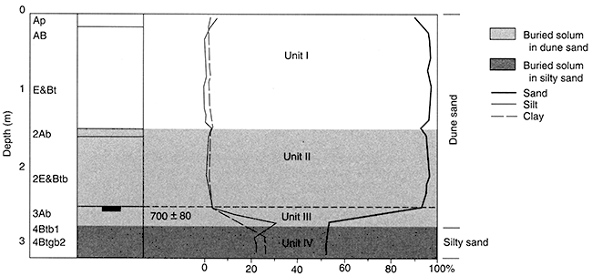
The lowermost deposit is Unit IV, extending from 2.70 m (8.9 ft) to the base of the profile (figs. 27, 28). Unit IV includes very poorly sorted sediments, sandy clay-loam in texture, that are consistent with other deposits in the region generically categorized as silty sand. Evidence (e.g., very poor sorting, fining-upward sequences) obtained elsewhere (e.g., Edwards 2-4) suggests that these deposits accumulated during the late Wisconsinan or very early Holocene in a relatively moist, low-energy environment where fluvial or lacustrine processes probably dominated. Periodically, Unit IV must have been exposed and stable, as evidenced by a well-developed buried soil, consisting of two Btb horizons with prismatic structure, that formed in the deposit (fig. 28). Gleying in the lowermost horizon suggests long-term ponding of surface water or high ground-water tables from time to time.
Unit III ranges from 2.57 m to 2.70 m (8.4-8.9 ft) (figs. 27, 28). In general, this unit is consistent in texture, structure, and color with sediments categorized as eolian sand in the region, deposits that accumulated in a relatively warm, arid environment. Texture, for example, shows an abrupt increase in sand from the underlying, presumably alluvial Unit IV. Although sorting is improved in Unit III, it is still very poor, suggesting a nearby, very poorly sorted source area such as the underlying silty sand. Alternatively, mobilizing winds could have varied in intensity, resulting in accumulation of various textures. Essentially, Unit III consists of a 3Ab soil horizon (fig. 28) with weak, subangular blocky structure, parting to single grain, that is also characteristic of a soil buried in eolian sand. A radiocarbon age of about 700 yr B.P. (figs. 27, 28) suggests accumulation during the very late Holocene when the climate was apparently warm with less effective moisture, one that promoted inhabitation by C4 plants, as implied by a δ13C value of -14.4‰.
The surficial deposits at Reno 3 consist of two stratigraphic units, Units II and I. Similar in character (figs. 27, 28), the sediments clearly represent a period of eolian sand deposition, one that was punctuated by a brief period of soil formation at the end of Unit II sedimentation. The deposits in both units are classified as sand, with as much as 97.4% sand present (e.g., 1.0 m; 3.3 ft). Compared to the underlying deposits, in Units II and I sorting improves considerably, becoming moderate; this suggests that eolian processes were dominant and the source was relatively well sorted. Each unit contains a weakly developed soil virtually identical in character, consisting of thin A horizons overlying thick E&Bt horizons. Although the development of Bt horizons (fig. 28) suggests long-term stability, they are distinguished only by the presence of thin, weakly developed silt and clay lamellae that could have formed in a relatively brief period of time. In addition, the structure of the E&Bt horizons is single grain, further indicating short-term pedogenesis. Overall, both Units II and I appear to have accumulated sometime in the very late Holocene, as suggested by a maximum-limiting age of about 700 yr B.P. from the underlying 3Ab (figs. 27, 28). The last millennium at Reno 3, therefore, can be characterized as a period of episodic, eolian sand deposition. The lack of a well-developed surface soil suggests that the site has been stable for only a brief period of time.
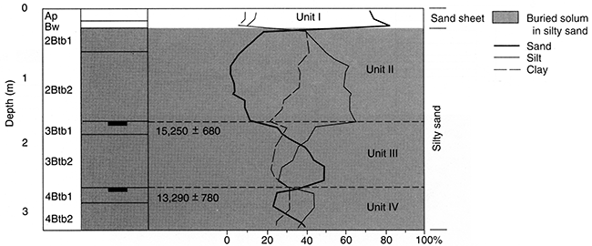
Reno 4
Reno 4 is a 4-m (13-ft)-deep section (figs. 7, 29), exposed by backhoe trenching, located in a compound subparabolic dune field in the SE SW sec. 10, T. 25 S., R. 10 W. (fig. 6). Three pedostratigraphic units, consisting of silty sand overlain by eolian sand, were described (figs. 29, 30). The sedimentological and pedogenic differences among the units appear to reflect diachronous depositional environments at the site in the past 20,000 years. Sediments are generally noncalcareous, loamy, poorly to very poorly sorted, finely skewed, mesokurtic to very leptokurtic, and have a mean particle size ranging from fine silt to fine sand (Arbogast, 1995).
Figure 29--The 4-m (13-ft)-high exposure at Reno 4, showing the position of pedostratigraphic units and radiocarbon ages.
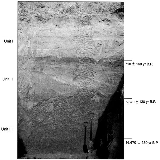
Figure 30--Pedostratigraphy, soil horizonation, and texture at Reno 4.
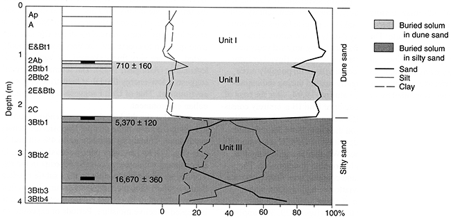
The lowest unit, Unit III, ranges from 2.27 m (7.4 ft) to the base of the profile (figs. 29, 30) and consists largely of gleyed silt, with significant amounts of sand and clay (fig. 30). Essentially, Unit III is very poorly sorted but is extremely poorly sorted in some places. A radiocarbon age of about 17,000 yr B.P. was derived from the lower part of the stratum (figs. 29, 30), suggesting sedimentation during the Woodfordian. Unfortunately, diagnostic sedimentary structures are not preserved, making a precise facies determination problematic. The very poorly sorted nature of the deposit, coupled with a distinct fining-upward sequence (fig. 30), however, suggests a low-energy fluvial or lacustrine environment. Cool conditions, with possibly more effective moisture, apparently existed during sedimentation, as implied by a δ13C value of -19.9‰ near the base of the unit. Overall, the character of Unit III is entirely consistent with other deposits (Edwards 1-4, Reno 3) generally categorized as silty sand on the Great Bend Sand Prairie.
Subsequent to the deposition of Unit III, an extremely well developed soil formed. Whether the soil formed in one interval or several is impossible to determine. The solum is slightly gleyed and contains very little carbonate, suggesting intensive illuviation or high ground-water tables. A radiocarbon age of about 5,400 yr B.P. was obtained from the top of the soil (figs. 7, 29, 30), implying exposure during the late Holocene.
Overlying, with a very sharp contact, are Units II and I (figs. 29, 30). Although Units II and I represent different pedostratigraphic intervals, they can be grouped together because they are so similar in nature. In stark contrast to the underlying silty sand, Units II and I consist of very sandy deposits that are much better sorted (fig. 30). Units II and I are virtually identical in character (e.g., texture, color, structure, stratigraphic position, topographic expression) to deposits recognized throughout the Great Bend Sand Praire as wind-blown, dune sand. Such an eolian source implies a relatively warm environment with less effective moisture than that in which the silty sand was deposited.
A maximum-limiting age of approximately 5,300 yr B.P., taken from the top of Unit III, suggests that dune sand accumulated during the late Holocene at Reno 4. Sedimentation of eolian sand has been episodic, as indicated by the buried soil recognized at the top of Unit II. A radiocarbon age of about 700 yr B.P. from the upper part of the soil (figs. 7, 29, 30) suggests stability occurred between 1,000 and 500 years ago. Soil formation evidently lasted for some time, as indicated by the Btb horizons and E&Btb horizon (fig. 30) observed in the solum. Apparently, the soil was rapidly buried by an influx of relatively coarse, better-sorted eolian sand. Approximately 1.10 m (3.6 ft) of sand has accumulated at Reno 4 in the past few hundred years. The degree of surface soil development (i.e., two A horizons, E&Bt horizon; fig. 30) indicates that the dune has been stable for perhaps several hundred years.
Prev Page--Previous Research, Methods || Next Page--Results, Continued
Kansas Geological Survey, Geology
Placed on web March 16, 2016; originally published 1998.
Comments to webadmin@kgs.ku.edu
The URL for this page is http://www.kgs.ku.edu/Publications/Bulletins/242/04_results.html