![]()
Prev Page--Introduction || Next Page--Investigations, Small Valleys
Geomorphic and stratigraphic investigations
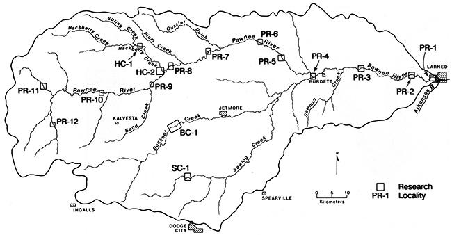
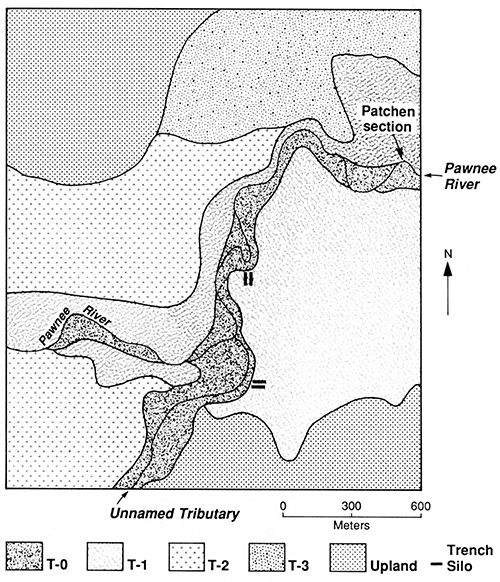
In this section I present the geomorphic and alluvial-stratigraphic information gathered at 16 localities in the study area (fig. 16). First, results of investigations are presented for localities in the main valley of the Pawnee River, beginning at the east end of the basin (PR-1 through PR-10). This discussion is followed by descriptions of the geomorphology and alluvial stratigraphy at localities in small valleys in the study area. Geomorphic and alluvial-stratigraphic data collected from large and small valleys are compared in the next section.
Figure 16--Pawnee River basin and localities where detailed soil-stratigraphic investigations were conducted.
Large valleys
Locality PR-1
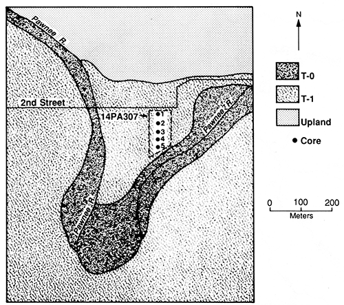
Locality PR-1 is situated in the Pawnee River valley, 1.5 km (0.93 mi) upstream from the confluence of that river with the Arkansas River (fig. 16). The Pawnee River is a sixth-order stream and has a gradient of 0.62 m/km (3.3 ft/mi) at this locality. The valley floor is 2.3 km (1.4 mi) wide and is bordered by a steep bedrock valley wall to the north. A low, broad ridge separates the Pawnee River valley from the Arkansas River valley to the south.
Two landforms compose the valley floor at locality PR-1: a narrow modern floodplain (T-0) and a low, broad terrace (T-1) (fig. 17). A 3-m-high (10-ft-high) scarp separates the T-0 and T-1 surfaces. T-1 is a paired terrace, and its broad, flat surface forms most of the valley floor.
Subsurface investigations at locality PR-1 focused on T-1 fill of the Pawnee River at the Lewis site (14PA307) (fig. 17). This site, which was initially referred to as the Larned site (Monger, 1970), is a large multicomponent Late Prehistoric village situated in the neck of a narrow meander bend of the Pawnee River (Ranney, 1988). Five cores were taken along a 120-m (400-ft) transect extending from 2d Street south to the Pawnee River (fig. 17). Core 3, which is the longest of the five cores, reached bedrock at a depth of 8.53 m (28 ft) below the T-1 surface. This core was used to prepare a detailed description of the alluvial stratigraphy at site 14PA307 (see appendix table A.1). In addition, a soil sample was collected from a buried paleosol for radiocarbon dating.
Figure 17--Landform map of locality PR-1 showing location of site 14PA307 and coring sites.
Three stratigraphic units and two buried paleosols were identified beneath the T-1 surface at site 14PA307 (fig. 18). The lowest unit (unit III) is 5.96 m (19.6 ft) thick and consists of fine- and coarse-grained alluvium. Sand and gravel composing the lower 4.34 m (14.2 ft) of unit III grade upward to silt loam and silty clay. Soil 3 is developed in the fine-grained alluvium at the top of unit III. This paleosol has Bk-BCk-C horizonation; the A horizon apparently was stripped off by erosion before burial. The 3Bkb horizon is 53 cm (1.7 ft) thick and is a brown (10YR 5/3, dry) silty clay. There are many distinct threads of calcium carbonate (stage I+) in the 3Bkb horizon, and the paleosolum has moderate fine and medium subangular-blocky structure.
Figure 18--Soil stratigraphy observed in core 1 (T-1 fill) at locality PR-1.
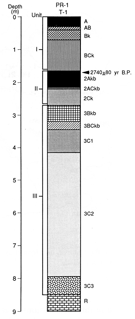
Unit II is 1.15 m (3.77 ft) thick and is composed of loamy fine sand at its base that grades upward to silt loam. A paleosol (soil 2) with Ak-ACk horizonation is developed at the top of this alluvial unit. The 2Akb horizon is 60 cm (2.0 ft) thick and is dark-grayish-brown (10YR 4/2, dry). Films and threads of calcium carbonate are common (stage I+) in the 2Akb and 2ACkb horizons but do not continue down into the 2C horizon.
The upper stratigraphic unit (unit I) is 1.70 m (5.58 ft) thick and is composed of alluvium that fines upward from loam to silt loam. A Haplustoll (soil 1) with A-Bk-BCk horizonation is developed at the top of unit I. The A horizon of this modern surface soil is 33 cm (1.1 ft) thick and is not completely leached of calcium carbonate based on reaction to HCl. The Bk horizon (Bk1 + Bk2) is only 37 cm (1.2 ft) thick and has fairly weak structural development and carbonate morphology (stage I+).
Based on the paleosol record, aggradation was interrupted by two soil-forming intervals before final stabilization of the T-1 surface. Soil 3 at the top of unit III has a well-developed Bk horizon indicative of a relatively long period of landscape stability. Soil 2 at the top of unit II, however, lacks a B horizon, and its over-thickened A horizon suggests that pedogenesis accompanied slow aggradation. Humates from the upper 20 cm (0.66 ft) of soil 2 yielded a radiocarbon age of 2,740 ± 80 yr B.P. Hence the episode of floodplain stability indicated by soil 2 dates back to at least ca. 2,740 yr B.P., and unit I aggraded sometime after that.
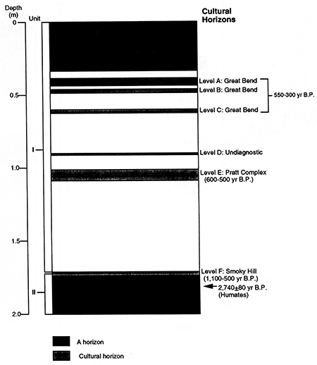
The modern soil at the top of unit I developed when sedimentation ceased or dramatically slowed on the T-1 surface. The presence of six separate cultural horizons (levels A-F, fig. 19) in the upper 1.72 m (5.64 ft) of the T-1 fill indicates that sedimentation was sporadic after ca. 2,700 yr B.P. The lowest cultural horizon (level F) is 1.67-1.72 m (5.48-5.64 ft) below the T-1 surface and contains Smoky Hill pottery and projectile points (Ranney, 1988). Based on radiocarbon assays. from other localities in Kansas, the Smoky Hill variant spans the period 1,100-500 yr B.P. (Brown and Simmons, 1987, p. XVIII-10). Level E is 1.02-1.11 m (3.35-3.64 ft) below the T-1 surface and represents the Pratt complex (ca. 600-500 yr B.P.). Level D is a thin layer of undiagnostic artifacts, 0.90-0.93 m (2.95-3.05 ft) below the T-1 surface. Great Bend cultural components are represented in levels A, B, and C, 0.38-0.42 m (1.25-1.38 ft), 0.46-0.49 m (1.51-1.61 ft), and 0.60-0.63 m (1.97-2.07 ft) below the T-1 surface, respectively (Ranney, 1988). Radiocarbon assays and cross-dating place the Great Bend aspect between ca. 550 and 300 yr B.P. (Brown and Simmons, 1987, p. XVI-10). Hence the upper 38 cm (1.3 ft) of the T-1 fill at site 14PA307 accumulated sometime after ca. 550-300 yr B.P.
Figure 19--Cultural horizons at site 14PA307 at locality PR-1.
Locality PR-2
Locality PR-2 is situated in the Pawnee River valley, 11 km (6.8 mi) upstream from the confluence of that river with the Arkansas River (fig. 16). The Pawnee River in this area is a sixth-order stream with a gradient of 0.75 m/km (4.0 ft/mi). The valley is asymmetric: north-facing slopes are steep but south-facing slopes are much gentler. The valley floor is 8 km (5 mi) wide and is composed of three landforms: a modern floodplain (T-0), a low terrace (T-1), and a high terrace (T-3) (fig. 20). An intermediate terrace (T-2) observed in the middle reaches of the Pawnee River was not detected at locality PR-2. The T-0 surface is 30-75 m (98-246 ft) wide and is separated from the T-1 surface by a steep 4-m-high (13-ft-high) scarp. T-1 is a paired terrace, and its broad, flat surface dominates the valley floor. A gently sloping 3-m-high (10-ft-high) scarp separates the T-1 surface from the T-3 terrace. T-3 is a paired terrace with a fairly broad, gently sloping surface.
Two former channels of the Pawnee River traverse the T-1 terrace south of the modern channel (fig. 20). The northernmost of these two abandoned channels has been greatly modified by land-leveling operations of farmers and no longer carries runoff. The southernmost channel, however, is occupied by Sawmill Creek, which is an intermittent stream. Avulsions and concomitant channel abandonment by the Pawnee River are discussed later.
Figure 20--Landform map of locality PR-2 showing location of cores and auger holes.
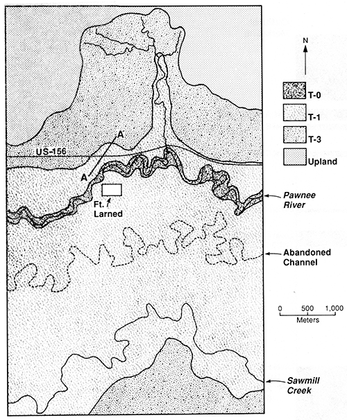
Subsurface investigations at locality PR-2 focused on valley fill beneath the T-1 and T-3 terraces. A series of cores and auger holes were drilled along a southwest to northeast transect (A-A' in fig. 20). The first core hole (core 1) was drilled on the T-1 terrace north of the Pawnee River between Fort Larned and US-156 (fig. 20). Unfortunately, a high water table prevented coring to bedrock. However, a continuous 8.53-m-long (28.0-ft-long) core of T-1 fill was successfully recovered. In addition, an 8.75-m-long (28.7-ft-long) core (core 2) was taken from T-3 fill immediately north of US-156, and four auger holes were drilled along the transect between cores 1 and 2. The cores were described, and a soil sample was collected from core 1 for radiocarbon dating.
Three stratigraphic units and two buried paleosols were identified beneath the T-1 surface at the core 1 site (fig. 21). The lowest unit (unit III) is at least 5.08 m (16.7 ft) thick and is composed of fine-loamy and clayey alluvium (see appendix table A.2). A paleosol (soil 3) with an ABk profile is developed at the top of unit III. The 3Ab horizon is 89 cm (2.9 ft) thick and is a dark-grayish-brown (10YR 4/2, dry) silty clay loam. There is no evidence of secondary carbonates within the 3Ab horizon, and the matrix is noncalcareous. Humates from the upper 10 cm (0.33 ft) of this over-thickened A horizon yielded a radiocarbon age of 10,100 ± 130 yr B.P. The underlying 3Bkb is 45 cm (1.5 ft) thick and is a light-yellowish-brown (2.5Y 6/4, dry) silty clay. Although secondary carbonates (stage II) are common in the 3Bkb horizon, the soil matrix is noncalcareous. The underlying 3Cgb horizon is massive and consists of alluvium with silty clay loam texture. A high water table has produced strong gleying in the 3Cgb horizon.
Figure 21--Soil stratigraphy observed in core 1 (T-1 fill) at locality PR-2.
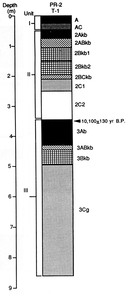
The second unit (unit II) is 2.84 m (9.32 ft) thick and is composed of fine-grained alluvium. A paleosol (soil 2) with Ak-Bk horizonation is developed at the top of unit II. The 2Akb horizon is 25 cm (0.82 ft) thick and is a dark-grayish-brown (10YR 4/2, dry) light silty clay loam. Carbonate morphology is weak in the 2Akb horizon, barely meeting the criteria for stage I development. The underlying 2Bkb horizon (2Bkb1 + 2Bkb2) is 94 cm (3.1 ft) thick and is a brown (10YR 4/3, dry) heavy silty clay loam. It is characterized by medium subangular-blocky structure and stage II carbonate morphology. However, there is little evidence of clay illuviation in the 2Bkb horizon. Silty, stratified alluvium composes the lower 1.33 m (4.36 ft) of unit II.
A 61-cm-thick (2.0-ft-thick) surface deposit (unit I) of fine-silty alluvium mantles soil 2. The modern surface soil (soil 1) at the top of unit I is a Haplustoll with a weakly developed Ap-AC profile. The Ap horizon is 20 cm (0.66 ft) thick and is a dark-grayish-brown (10YR 4/2, dry) light silty clay loam. The underlying AC horizon consists of brown (10YR 5/3, dry) calcareous silt loam.
Based on the mean residence time for organic carbon at the top of soil 3 (ca. 10, 100 yr B.P.), alluvium composing the upper 3.45 m (11.3 ft) of the T-1 fill at locality PR-2 was deposited during the Holocene. At least one major episode of landscape stability and soil formation (soil 2) occurred after ca. 10,100 yr B.P. Soil 2, which has a moderately developed A-Bk profile, was buried beneath overbank alluvium (unit I). Although the time of burial is unknown, extremely weak soil development at the top of unit I suggests that this deposit is Historic in age.
Soil 2 strongly resembles the surface soil (soil 1) at site 14PA307 at locality PR-1. Hence soil 1 at locality PR-1 may occur as a buried paleosol (soil 2 at locality PR-2) where it has been mantled by Historic overbank deposits. However, additional absolute time control is needed before these soils can be correlated over such great distances.
Core 2 at locality PR-2 was taken from T-3 fill at a location 205 m (673 ft) northeast of core 1 (fig. 20). This second core revealed three stratigraphic units and two buried paleosols beneath the T-3 surface (fig. 22). The lowest unit (unit III) is at least 1.43 m (4.69 ft) thick and is composed of loamy sediment. A paleosol (soil 3) with a thick carbonate-rich Bk horizon is developed at the top of unit III (see appendix table A.3); the A horizon was stripped off by erosion before burial. The 3Bkb horizon is yellowish brown (10YR 5/4, dry) and has medium subangular-blocky structure. Approximately 15% of the matrix has been whitened by calcium carbonate, and soft carbonate masses are common (stage II) in this paleosol.
Figure 22--Soil stratigraphy observed in core 2 (T-3 fill) at locality PR-2.
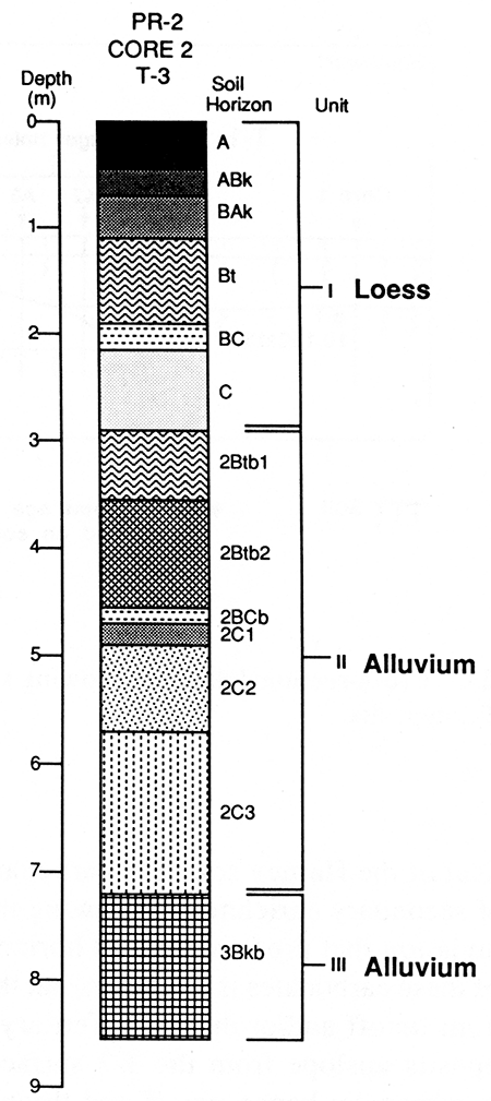
Soil 3 is mantled by a 4.32-m-thick (14.2-ft-thick) unit of alluvium (unit II). Loamy fine sand at the bottom of unit II grades upward to silty clay loam at the top of the unit. A truncated Bt horizon (soil 2) is developed in the upper 1.65 m (5.41 ft) of unit II. The 2Btb horizon (2Bt1 + 2Bt2) is 1.83 m (6.00 ft) thick and is a reddish-yellow (7.5YR 6/6, dry) to brownish-yellow (10YR 5/6, dry) silty clay loam. Clay illuviation is indicated by distinct clay flows on vertical ped faces in the 2Btb I and 2Btb2 horizons. The matrix is noncalcareous, and there is no evidence of secondary carbonates. Based on its color and morphology, soil 2 appears to be the product of a strong weathering environment and/or a long episode of pedogenesis.
The upper stratigraphic unit (unit I) is 2.92 m (9.58 ft) thick and is composed of pale-brown (10YR 6/3, dry) to light-yellowish-brown (10YR 6/4, dry) massive silt loam. The surface soil at the top of unit I is an Argiustoll (Mollisol) with A-BAk-Btk-Bk-BCk horizonation. The A horizon is 42 cm (1.4 ft) thick and is brown (10YR 5/3, dry) to grayish brown (10YR 5/2, dry). The A horizon is leached of calcium carbonate, secondary carbonates (stage I+) are present in the BAk horizon and continue down into the BCk horizon. The argillic horizon (Btk1 + Btk2) is 1.19 m (3.90 ft) thick and is a brown (10YR 5/3, dry) silty clay loam. This soil is somewhat characteristic of the Harney series on 1-3% slopes. The Harney silt loam is developed in Peoria loess throughout much of western Kansas (Soil Conservation Service, 1986) and has been mapped on the T-3 terrace at locality PR-2 [see Dodge and Roth (1978, sheet 27)]. However, the presence of carbonates within the argillic horizon is not typical of the Harney soil. The carbonates must be a result of secondary enrichment following the episode of clay illuviation that produced the Bt horizon. The exact origin of these carbonates is unknown, but they may have come from runoff and/or dust fall. Tertiary and Quaternary deposits upslope from the T-3 surface are rich in calcium carbonate; hence runoff and throughflow from higher positions in the valley landscape are likely to be charged with carbonates. Also, carbonate-rich dust from local and western sources may have been deposited on the T-3 surface during the Holocene. According to Twiss (1983), dust currently is deposited at a rate of 371,600 kg/km2/yr (436,500 lb/mi2/yr) in western Kansas.
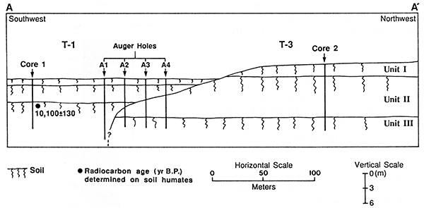
Four auger holes were drilled along a transect between cores 1 and 2 to determine stratigraphic relations between T-1 and T-3 deposits. The results of this investigation indicate that T-1 fill is inset above T-3 fill near the scarp that separates the two terraces (fig. 23). The 2Btkb horizon (soil 2) observed in the T-3 fill crops out at the base of the scarp and was detected below the T-1 fill near the boundary between the T-1 and T-3 terraces.
Figure 23--Cross-sectional diagram showing stratigraphic relationship between T-3 and T-1 deposits.
Although the absolute age of the alluvium composing T-3 fill is unknown, the alluvium was deposited sometime before 10,240 ± 120 yr B.P., which is the oldest radiocarbon age determined on soil humates from the T-1 fill. Also, if unit I is Peoria loess, aggradation of the underlying T-3 fill must predate the late Wisconsinan.
Locality PR-3
Locality PR-3 is situated in the Pawnee River valley, 28 km (17 mi) upstream from the confluence of that river with the Arkansas River (fig. 16). The Pawnee River is a sixth-order stream and has a gradient of 0.76 m/km (4.0 ft/mi) at this locality. The valley floor is 6.5 km (4.0 mi) wide and is composed of three landforms: a narrow floodplain (T-0), a low broad terrace (T-1), and a high terrace (T-3) (fig. 24). An intermediate terrace (T-2) observed at locality PR-8 in the middle Pawnee River valley was not detected at locality PR-3. The T-0 surface is 30-75 m (98-250 ft) wide and is separated from T-1 by a 4-m-high (I3-ft-high) scarp. T-1 is a paired terrace, and its broad, flat surface dominates the valley bottom. A distinct 4.5-m-high (15-ft-high) scarp separates the T-1 surface from the T-3 surface. As was the case downstream at locality PR-2, T-3 is a paired terrace with a fairly broad, gently sloping surface.
The two abandoned channels of the Pawnee River observed at locality PR-2 also cross locality PR-3 (fig. 24). Both channels are cut into T-1 fill, and the southernmost channel is occupied by one of two area streams called Sawmill Creek.
Figure 24--Landform map of locality PR-3 showing location of Elmore trench.
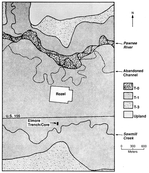
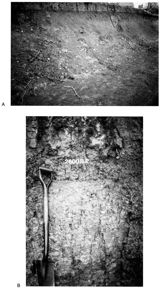
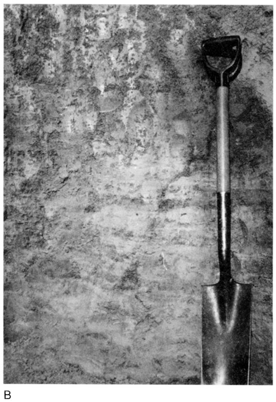
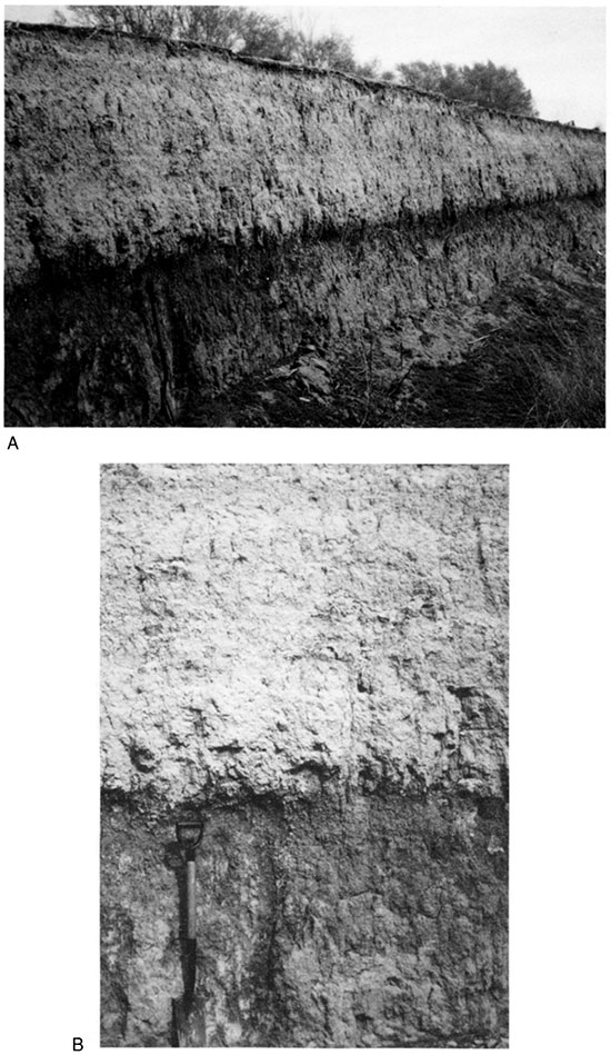
The subsurface investigation at locality PR-3 focused on valley fill beneath the T-1 surface. Alluvial deposits and a buried soil are exposed in a trench silo that was excavated into T-1 fill on the southern side of the valley floor (fig. 24). In addition to examining the soil stratigraphy exposed along the walls of the trench (fig. 25), I recovered a 2.1-m-long (6.9-ft-long) core below the floor of the trench with the Giddings Hydraulic Probe. A detailed description of the west wall of the trench was combined with that of the core (see appendix table A.4). This study site is referred to as the Elmore trench.
Figure 25--(A) Elmore trench and (B) close-up of T-1 fill exposed in the wall of the silo. The radiocarbon age was determined on humates from the upper 20 cm of the 2Ab horizon. Note the secondary carbonates and structural development in the 2Bkb horizon.
Three stratigraphic units and two buried soils were identified beneath the T-1 surface at the Elmore trench (fig. 26). The lowest unit (unit III) is at least 1.09 m (3.6 ft) thick and is composed of fine-grained sediment. A paleosol (soil 3) with a Bt horizon is developed at the top of unit III; the A horizon was removed by erosion before burial. The 3Btb1 horizon is reddish yellow (7.5YR 6/6, dry) and has a silty-clay texture. Discontinuous clay films were detected on vertical and horizontal ped faces throughout the paleosolum. The soil matrix is noncalcareous, and no secondary carbonates were observed in the 3Btb1 and 3Btb2 horizons.
Figure 26--Elmore trench and core showing stratigraphic units, soils, and radiocarbon age.
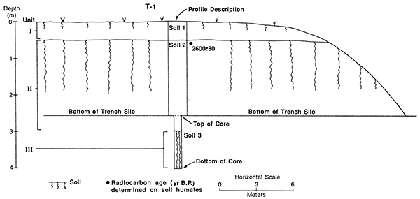
Unit II is 2.52 m (8.27 ft) thick and is composed of stratified and massive loamy and clayey alluvium. A paleosol (soil 2) with Ak-Bk horizonation is developed at the top of unit II (fig. 25B). The 2Akb horizon is 30 cm (1 ft) thick and is a dark-grayish-brown (10YR 4/2, dry) light silty clay loam. Carbonate morphology is weak in the 2Akb horizon (stage I), but it becomes better developed with increasing depth in the paleosolum. The 2Bkb horizon (2Bkb1 + 2Bkb2) is 78 cm (2.6 ft) thick and is a brown (10YR 5/3, dry) silty clay. There is fine and medium subangular-blocky structure within the 2Bkb horizon, and distinct films, threads, and soft masses of calcium carbonate (stage II) occur throughout this horizon. Alluvium composing the lower 80 cm (2.6 ft) of unit II (2C1 and 2C2 horizons) consists of finely laminated sandy loam, loam, silt loam, silty clay loam, and silty clay.
The upper unit (unit I) is 45 cm (1.5 ft) thick and is composed of fine-grained alluvium. The modern surface soil at the top of unit I is a Haplustoll with a weakly developed A-AC profile. The A horizon is 24 cm (0.79 ft) thick and is a grayish-brown (10YR 5/2, dry) silt loam. Thin, faint beds of calcareous silt loam compose the underlying AC horizon.
Cores taken along a transect of the T-1 terrace reveal that unit I thins and eventually disappears southward, away from the Elmore trench silo. Hence soil 2 at the top of unit II is the surface soil where unit I is absent.
Humates from the upper 20 cm (0.66 ft) of soil 2 yielded a radiocarbon age of 2,600 ± 80 yr B.P. Therefore alluvium composing unit II accumulated before ca. 2,600 yr B.P., and unit I aggraded sometime later. The weakly developed A-AC profile of soil 1 suggests that unit I is very young. Although no Historic artifacts were discovered in unit I, the landowner reported that this silty deposit has yielded square nails and colored glass at nearby locations (George Elmore, personal communication, 1988). The age of the reddish truncated Bt horizon (soil 3) at the top of unit III is unknown, but it strongly resembles soil 2 developed in T-3 fill at locality PR-2. The presence of this paleosol beneath the T-1 surface at locality PR-3 was not unexpected, given the closeness of the Elmore trench to the scarp separating the T-1 and T-3 surfaces. As noted earlier, subsurface investigations at locality PR-2 determined that the T-1 fill truncates the T-3 fill near the boundary between these two terraces (see fig. 23). If that is the case at the Elmore trench, soil 3 may be the same truncated paleosol observed beneath Peoria loess on the T-3 terrace. Hence soil 3 and the alluvium into which it is developed may predate the late Wisconsinan.
Other similarities exist between the soil stratigraphy at localities PR-3 and PR-2. Specifically, the A-Bk profile of soil2 developed in T-1 fill at locality PR-3 is nearly identical with the A-Bk profile of soil 2 developed in T-1 fill at locality PR-2. Also, at both sites soil 2 is mantled by a relatively thin deposit of loamy alluvium (unit I) with a weakly developed surface soil (A-AC profile). Correlations between localities PR-3 and PR-2 must be considered tentative, however, in the absence of supporting radiocarbon ages.
Locality PR-4
Locality PR-4 is situated at the confluence of Buckner Creek and the Pawnee River (fig. 16). The valley floor is 6.5 km (4.0 mi) wide and is composed of three landforms: a modern floodplain (T-0), a low terrace (T-1), and a high terrace (T-3) (fig. 27). Again, the intermediate terrace (T-2) was not observed in this portion of the Pawnee River valley. The T-0 surface is 20-50 m (66-164 ft) wide and is separated from the T-1 surface by a steep 4-m-high (13-ft-high) scarp. The broad paired surface of the T-1 terrace dominates the valley floor and is separated from the adjacent T-3 terrace by a moderately sloping 3-m-high (10-ft-high) scarp. T-3 is a paired terrace with a fairly broad, gently sloping surface.
Figure 27--Landform map of locality PR-4 showing the location of the Rucker section.
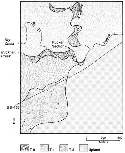
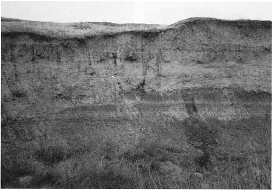
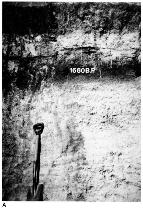
Both Buckner Creek and the Pawnee River have migrated laterally, cutting into T-1 fill that separates the two streams near their confluence (fig. 27). An 8.5-m-high (28-ft-high) cutbank located along Buckner Creek about 300 m (1,000 ft) upstream from its junction with the Pawnee River provided an opportunity to study a thick section of the T-1 fill (fig. 28). This cutbank exposure, designated as the Rucker section, is described in appendix table A.5, and three soil samples were collected for radiocarbon dating.
Figure 28--Rucker section at locality PR-4.
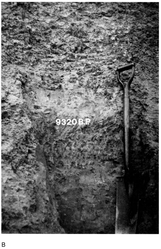
Four stratigraphic units and three buried paleosols have been identified in the Rucker section (fig. 29). The lowest stratigraphic unit (unit IV) is at least 2.56 m (8.40 ft) thick and is composed of fine-loamy alluvium. A truncated paleosol (soil 4) is developed at the top of unit IV. Soil 4 has a 40-cm-thick (1.3-ft-thick) Btk horizon above a BCk horizon; the A horizon was stripped off by erosion before burial. The 4Btkb horizon is yellowish brown (10YR 5/4, dry) and is a silty clay loam. Although relatively few clay flows were observed on ped faces in the 4Btkb horizon, many films and threads of calcium carbonate (stage I+) are present in soil 4. Humates from the upper 20 cm (0.66 ft) of soil 4 yielded a radiocarbon age of 9,320 ± 120 yr B.P.
Figure 29--Cross-sectional diagram of the Rucker section showing stratigraphic units, soils, and radiocarbon ages.
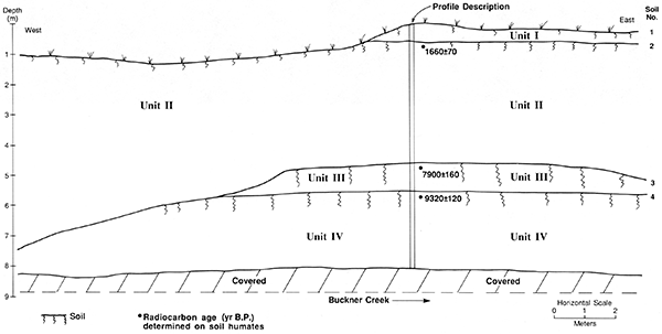
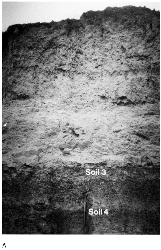
Unit III overlies unit IV except where the former was stripped off by erosion at the west end of the section (fig. 29). Unit III is 1.2 m (3.9 ft) thick and is composed of fine-loamy alluvium. Soil 3 is developed at the top of unit III (fig. 29) and, like soil 4, is a truncated paleosol. The A horizon of soil 3 was removed by erosion, leaving a profile with Bk-Btk-BCk horizonation. The thick, strongly developed paleosolum of soil 3 stands out in the section (fig. 30). Soil colors range from yellowish brown (10YR 5/4, dry) in the 3Bkb horizon to brown (10YR 5/2, dry) in the 3Btkb horizon. The 3Bkb and 3Btkb horizons are characterized by silty clay loam texture, fine and medium subangular-blocky structure, and stage II carbonate morphology. Also, distinct clay films were observed on ped faces in the 3Btkb horizon. Humates from the upper 20 cm (0.66 ft) of soil 3 yielded a radiocarbon age of 7,900 ± 160 yr B.P.
Figure 30--Rucker section. (A) Soils 3 and 4 at the base of the exposure. (B) Strong structural development in the truncated Bt horizon of soil 3 and moderate development in the truncated Bt horizon of soil 4. Radiocarbon ages determined on humates from the upper 20 cm of these buried soils.
Unit II mantles unit III across the eastern two-thirds of the section and overlies unit IV at the western end (fig. 29). Unit II is about 3.4 m (11 ft) thick and consists of stratified silt loam and fine sandy loam. Soil 2, which is developed at the top of unit II, has a dark A horizon above an ACk horizon (fig. 31). The 2Ab horizon is 40 cm (1.3 ft) thick, dark gray (10YR 4/1, dry), and leached of carbonates. A radiocarbon age of 1,660 ± 70 yr B.P. was determined on humates from the upper 20 cm (0.66 ft) of this horizon. The 2C horizons are pale brown (10YR 6/3, dry) to very pale brown (10YR 7/3, dry) and show little evidence of secondary calcium carbonate accumulation. However, alluvium composing the lower 3 m of unit II is calcareous, based on reaction to HCl. Horizontal bedding is clearly visible throughout the 2C2 horizon (fig. 31B), with strata <5 mm (<0.2 in.) thick collectively making up larger beds 1-10 cm (0.4-4 in.) thick.
Figure 31--Upper portion of the Rucker section. (A) Soils 1 and 2 developed at the top of units I and II, respectively. Radiocarbon age determined on humates from the upper 20 cm of soil 2. (B) Horizontal bedding in unit II below the 2Ab horizon.
Unit II is mantled by unit I, except where gullying has removed the latter (fig. 29). Unit I is 1.05 m (3.4 ft) thick and is composed of stratified fine-grained alluvium. The modern surface soil (soil 1) at the top of unit I is a Haplustoll (Mollisol) with A-ACk horizonation (fig. 31A). The A horizon is 38 cm (1.2 ft) thick and is a dark-grayish-brown (10YR 4/2, dry) to grayish-brown (10YR 5/2, dry) silt loam. The C horizon displays prominent bedding, with texture of strata ranging from silty clay loam to very fine sandy loam. Preservation of bedding at shallow depths combined with weak surface-soil development suggests that unit I is young. Altogether, the physical properties of unit I are characteristic of Historic alluvium. However, the absolute age of this unit is unknown.
Mean residence times determined on organic carbon from buried soils at the Rucker section provide a chronologie framework for Holocene aggradation, erosion, and landscape stability at locality PR-4. Specifically, unit IV aggraded sometime before 9,320 ± 120 yr B.P., which is the radiocarbon age of humates from soil 4 at the top of this unit. Soil 4 was truncated and subsequently mantled by alluvium composing unit III sometime after ca. 9,320 yr B.P. but before ca. 7,900 yr B.P. Development of soil 3 at the top of unit III was underway by at least 7,900 ± 160 yr B.P. This paleosol was truncated and then mantled by alluvium composing unit II sometime between ca. 7,900 and 1,660 yr B.P. Mean residence time for organic carbon at the top of soil 2 indicates that the surface of unit II was stable by at least 1,660 ± 70 yr B.P. Aggradation of unit I and concomitant burial of soil 2 occurred sometime after ca. 1,660 yr B.P.
The episode of stream incision that converted the late Holocene floodplain into a terrace (T-1) probably took place soon before ca. 1,600 yr B.P., thereby isolating the T-1 surface from frequent low-magnitude floods. This isolation would account for development of soil 2 at the top of unit II. As noted earlier, unit II appears to be mantled by Historic overbank deposits composing unit I. If the overbank alluvium is Historic in age, it was deposited on the T-1 surface at or before A.D. 1951, which is the last time that floodwaters covered the T-1 terrace at locality PR-4 (Don Rucker, personal communication, 1988). According to local landowners, both the Pawnee River and Buckner Creek have been downcutting since about A.D. 1970.
Locality PR-5
Locality PR-5 is situated in the Pawnee River valley, 51 km (32 mi) upstream from the confluence of that stream with the Arkansas River (fig. 16). The Pawnee River is a fifth-order stream with a gradient of 1.52 m/km (8.03 ft/mi) at this locality. The valley trends northwest-southeast, and its floor is 2.4 km (1.5 mi) wide. Four landforms compose the valley floor at locality PR-5: a modern floodplain (T-0), a low terrace (T-1), an intermediate terrace (T-2), and a high terrace (T-3) (fig. 32). The T-0 surface is 30-100 m (100-330 ft) wide and is separated from the adjacent T-1 surface by a steep 4-m-high (13-ft-high) scarp. T-1 is a paired terrace, and its broad, flat surface dominates the valley floor. A gently sloping 2-m-high (7-ft-high) scarp separates the T-1 surface from the T-2 surface. The T-2 terrace also is a paired surface, but it is relatively narrow compared to the T-1 terrace (fig. 32). A moderately sloping 3-m-high (10-ft-high) scarp separates the T-2 surface from the T-3 surface. The T-3 terrace has a gently sloping surface that merges with the valley walls.
Figure 32--Landform map of locality PR-5 showing location of Burdett trench, T-0 cutbank, and cores.
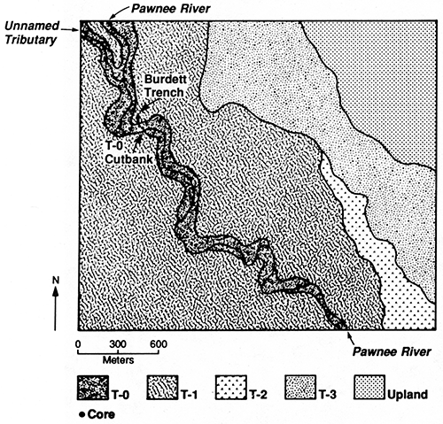
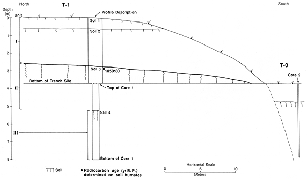
A 35-m-long (115-ft-long) trench silo (Burdett trench) extends from the base of the T-0/T-1 scarp back into the T-1 fill (fig. 33). The trench, which is 3.50 m (11.5 ft) deep at its north end, provided an opportunity to examine a relatively thick section of T-1 fill. In addition, a core was taken from the bottom of the trench (north end) to a depth of 4.25 m (13.9 ft). Altogether, 7.75 vertical meters (25.4 ft) of T-1 fill (core + trench wall) were examined and described at the Burdett locality. Also, a single soil sample was collected for radiocarbon dating.
Figure 33--Cross-sectional diagram of T-1 and T-0 fill at locality PR-5. Stratigraphic information was gleaned from cores, a cutbank exposure, and the Burdett trench.
In addition to examining the T-1 fill, I inspected alluvial deposits and soils beneath the T-0 surface in a cutbank exposure 40 m (131 ft) southeast of the Burdett trench (fig. 32). Also, two cores were taken from T-0 fill at locations between the cutbank and the trench (fig. 32). The cores were used to determine whether or not T-0 is an erosional surface cut into T-1 fill, that is, a fillstrath terrace.
Three stratigraphic units and three buried paleosols were identified below the T-1 surface at the Burdett trench (fig. 33). The lowest stratigraphic unit (unit III) is at least 2.83 m (9.28 ft) thick and consists of calcareous fine-grained alluvium. Sandy loam composing the lower 55 cm (1.8 ft) of the core grades upward to silt loam. A paleosol (soil 4) with Bk1-Bk2-BCk-C horizonation is developed at the top of unit III (see appendix table A.6); the A horizon apparently was removed by erosion before burial. The 4Bkb horizon (4Bkb1 + 4Bkb2) is 66 cm (2.2 ft) thick and is a brown (10YR 5/3, dry) silty clay loam. There are many films and threads of calcium carbonate (stage I+) throughout the 4Bkb horizon. Evidence of secondary carbonates is absent below the 4BCk horizon, but alluvium composing the C horizons of soil 4 appears to be calcareous based on reaction to HCl. The 4C1 and 4C2 horizons are massive in structure and have silt loam texture. The alluvium coarsens downward to fine sandy loam in the 4C3 horizon, and bedding is preserved from the top of the 4C3 horizon to the bottom of the core.
Unit II is 2.76 m (9.06 ft) thick and is composed of calcareous fine-grained alluvium. A paleosol (soil 3) with A-Bw-BC horizonation is developed at the top of unit II. The 3Ab horizon is 44 cm (1.4 ft) thick and is a very dark grayish brown (10YR 3/2, dry) silt loam. No secondary carbonates were observed in the 3Ab horizon, and its matrix is noncalcareous. Humates from the upper 20 cm (0.66 ft) of the 3Ab horizon yielded a radiocarbon age of 1,850 ± 80 yr B.P.
A thin, weakly developed cambic (Bw) horizon is present in soil 3. The 3Bwb horizon is 25 cm (0.82 ft) thick and is a yellowish-brown (10YR 5/4, dry) silt loam. Although no secondary carbonates were observed in the 3Bwb horizon, its matrix is calcareous. Soil 3 dips southward toward the edge of the T-1/T-0 scarp (fig. 33).
The upper unit (unit I) of the T-1 fill is 2.76 m (9.06 ft) thick and is composed of calcareous fine-grained alluvium. Thin horizontal beds of silty clay loam, silt loam, loam, and fine sandy loam make up the lower 1.91 m (6.27 ft) of unit 1. The remainder of this unit consists of silt loam that has been slightly altered by pedogenesis. A thin, faint buried soil (soil 2) with A-C horizonation was detected in the upper 85 cm (2.8 ft) of unit I (fig. 33). The 2Ab horizon is only 22 cm (0.72 ft) thick and has weak, fine, granular structure. The modern surface soil (soil 1) at the top of unit I also is weakly developed. Soil I is characterized by a 12-cm-thick (0.39-ft-thick) Ap horizon above an AC horizon.
Based on the radiocarbon age of humates from the upper 20 cm (0.66 ft) of soil 3, unit I aggraded sometime after ca. 1,850 yr B.P. The weakly developed soils and well-preserved bedding in unit I suggest that it is composed of Historic alluvium. Alluvium composing units II and III accumulated sometime before ca. 1,850 yr B.P.
As noted earlier, valley fill beneath the T-0 surface is exposed in a cutbank 40 m (131 ft) southeast of the Burdett trench. The section, which is 2.6 m (8.5 ft) thick and nearly 4 m (13 ft) long, has been examined and described (see appendix table A.7).
Two stratigraphic units and one buried soil were observed in the upper 2.60 m (8.53 ft) of the T-0 fill. The lowest stratigraphic unit (unit II) is at least 1.55 m (5.09 ft) thick and is composed of calcareous fine-grained alluvium. A thin paleosol (soil 2) with A-AC-C horizonation is developed at the top of unit II. The 2Ab horizon is 35 cm (1.1 ft) thick and is a dark-grayish-brown (10YR 4/2, dry) silt loam. The fill is massive below the 2ACb horizon, and thin beds of clayey and loamy alluvium are common in the 2C horizon.
Unit I is 1.05 m (3.4 ft) thick and also is composed of calcareous fine-grained alluvium. The modern surface soil (soil 1) at the top of this unit is a Haplustoll with A-AC-C horizonation. The A horizon is 25 cm (0.82 ft) thick and is a grayish-brown (10YR 5/2, dry) silt loam. The AC horizon is 30 cm (0.98 ft) thick and is a light-brownish-gray (10YR 6/2, dry) silt loam. Thin faint beds of loam, silt loam, and silty clay loam were observed in the lower 30 cm (0.98 ft) of the C horizon.
Two cores were taken from the T-0 fill to determine its stratigraphic relationship to the T-1 fill. Based on evidence from these cores, the T-0 fill is laterally inset against the T-1 fill (fig. 33). Hence the modern floodplain is not an erosional surface cut across the T-1 fill.
Locality PR-6
Locality PR-6 is situated in the Pawnee River valley, 61 km (38 mi) upstream from the confluence of that river with the Arkansas River (fig. 16). At this locality the Pawnee River is a fifth-order stream with a gradient of 1.25 m/km (6.6 ft/mi). The valley floor is 3.2 km (2.0 mi) wide and is composed of four landforms: the modern floodplain (T-0), a low terrace (T-1), an intermediate terrace (T-2), and a high terrace (T-3) (fig. 34). The modern floodplain is 20-150 m (66-490 ft) wide and is separated from the T-1 surface by a 4-m-high (13-ft-high) scarp. T-1 is a paired terrace, and its broad, flat surface is separated from the T-2 surface by a 1.5-m-high (4.9-ft-high) scarp. The broad, flat surface of the T-2 terrace dominates the valley floor at locality PR-6 (fig. 34). This paired terrace is separated from the T-3 surface by a gently sloping 2-m-high (7-ft-high) scarp.
Figure 34--Landform map of locality PR-6 showing location of Foos section.
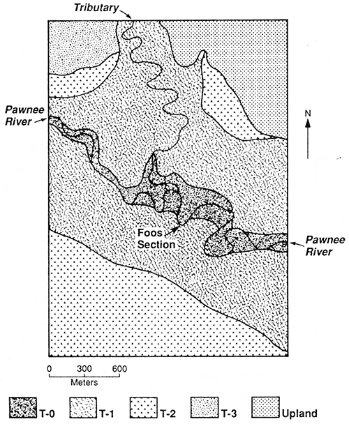
Subsurface investigations at locality PR-6 focused on T-1 fill exposed in several cutbanks along the Pawnee River. A representative cutbank, referred to as the Foos section, was selected for detailed study (fig. 35). The Foos section is described in appendix table A.8, and soil samples were collected for particle-size analysis and determination of calcium carbonate content. In addition, three soil samples were collected for radiocarbon dating.
Figure 35--Foos section at locality PR-6.
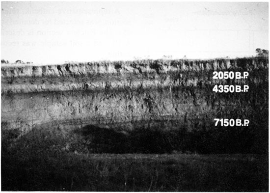
Four stratigraphic units and three buried paleosols were identified in the Foos section (fig. 36). The lowest unit (unit IV) is at least 94 cm (3.1 ft) thick and is composed of fine-grained alluvium. A paleosol (soil 4) with Ak-ABk-Btk horizonation is developed at the top of this unit. The 4Akb horizon is 54 cm (1.8 ft) thick and is a grayish-brown (10YR 5/2, dry) silty clay loam. The 4Btkb horizon is a brown (10YR 5/3, dry) silty clay. There is moderate, fine, subangular-blocky structure within the 4Btkb horizon, and clay illuviation is indicated by discontinuous argillans on ped faces. Carbonate morphology is weak (stage I) in the 4Akb and 4Btkb horizons. Although a few calcium carbonate films, threads, and concretions were observed in soil 4, carbonate content is relatively low, ranging from 2.5% to 4.1% (table 2).
Figure 36--Cross-sectional diagram of the Foos section showing stratigraphic units, buried paleosols, and radiocarbon ages.
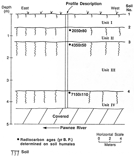
Table 2--Particle-size distribution and calcium carbonate content of sediment samples from the Foos section at locality PR-6
| Depth (cm) |
Soil horizon |
Particle-size distribution (mm) | ||||||||||||
|---|---|---|---|---|---|---|---|---|---|---|---|---|---|---|
| Sanda | Silt | |||||||||||||
| VC % (0.25-1.0) |
C % (0.10-0.5) |
M % (2.0-0.25) |
F % (0.02-0.10) |
VF % (0.05-0.05) |
Total % (2.0-0.05) |
Fine % (0.02-0.002) |
Total % (0.05-0.002) |
Total clay % (<0.002) |
Texture classb |
CaCO3 (%) | ||||
| 0-20 | A | 0.2 | 1.6 | 7.6 | 15.9 | 12.9 | 38.2 | 10.4 | 43.3 | 18.5 | L | 8.3 | ||
| 20-60 | Ac | 0.1 | 0.4 | 1.9 | 20.1 | 16.4 | 38.9 | 9.3 | 48.7 | 12.4 | L | 12.2 | ||
| 60-96 | 2Ab | 0.1 | 0.0 | 0.1 | 0.6 | 1.2 | 2.0 | 35.3 | 47.5 | 50.5 | SiC | 13.3 | ||
| 96-125 | 2Acb | 0.1 | 0.1 | 1.2 | 2.4 | 7.3 | 11.1 | 21.3 | 64.1 | 24.8 | SiL | 6.6 | ||
| 125-155 | 3Ab | 0.2 | 0.1 | 0.5 | 0.9 | 3.5 | 5.2 | 28.2 | 59.6 | 35.2 | SiCL | 2.2 | ||
| 155-170 | 3ABkb | 0.0 | 0.1 | 0.3 | 1.3 | 3.4 | 5.1 | 27.4 | 58.7 | 36.2 | SiCL | 4.7 | ||
| 170-200 | 3Bkb1 | 0.0 | 0.1 | 0.2 | 0.6 | 4.7 | 5.6 | 18.8 | 64.8 | 29.6 | SiCL | 6.2 | ||
| 200-240 | 3Bkb2 | 0.1 | 0.2 | 0.3 | 0.6 | 2.4 | 3.6 | 24.1 | 69.1 | 27.3 | SiCL | 4.4 | ||
| 240-282 | 3Bckb | 0.1 | 0.2 | 0.2 | 0.5 | 4.6 | 5.6 | 20.0 | 72.2 | 22.2 | SiL | 1.3 | ||
| 282-351 | 3ck | 0.0 | 0.1 | 0.2 | 4.1 | 10.3 | 14.7 | 19.7 | 62.0 | 23.3 | SiL | 1.2 | ||
| 351-405 | 4Akb | 0.0 | 0.3 | 0.3 | 0.7 | 1.2 | 2.5 | 45.6 | 57.8 | 39.7 | SiCL | 2.5 | ||
| 405-420 | 4ABkb | 0.0 | 0.1 | 0.2 | 0.6 | 0.6 | 1.5 | 48.5 | 56.4 | 42.1 | SiC | 3.9 | ||
| 420-445 | 4Btkb | 0.0 | 0.1 | 0.1 | 0.5 | 0.5 | 1.2 | 51.9 | 52.1 | 46.7 | SiC | 4.1 | ||
| a. VC, very coarse grained; C, coarse-grained; M, medium-grained; F, fine-grained; VF, very fine grained. b. L, loam; SiL, silt loam; SicL, silty clay loam; SL, sandy loam; LS, loamy sand. |
||||||||||||||
Unit III is 2.26 m (7.41 ft) thick and is composed of calcareous fine-grained alluvium. Loam interbedded with fine sandy loam composes the lower 69 cm (2.3 ft) of unit III. This stratified alluvium grades upward to massive silty clay loam composing the upper 1.15 m (3.77 ft) of the unit. A paleosol (soil 3) with A-Bk-C horizonation is developed at the top of unit III. The 3Ab horizon is 30 cm (0.98 ft) thick and dark grayish brown (10YR 4/2, dry). Carbonate content increases from 2.2% in the 3Ab horizon to 6.2% in the 3Bkb1 horizon (table 2). Films and threads of calcium carbonate in the 3ABkb horizon (stage I+) extend down into the 3Bkb horizon. The 3Bkb horizon (3Bkb1 + 3Bkb2) is 70 cm (2.3 ft) thick and is a pale-brown (10YR 6/3, dry) silty clay loam. Bedding is faint in the lower 10 cm (0.32 ft) of the 3BCkb horizon but becomes distinct down through the 3C horizon.
Unit II is 65 cm (2.1 ft) thick and also is composed of calcareous fine-grained alluvium. The alluvium fines upward from silt loam in the lower half of the unit to silty clay in the upper half. A thin paleosol (soil 2) with A-AC horizonation is developed at the top of unit II. The 2Ab horizon is 36 cm (1.2 ft) thick and grayish brown (10YR 5/2, dry). There is no evidence of clay illuviation or secondary carbonates in soil 2.
Unit I is 60 cm (2.0 ft) thick and is composed of calcareous loamy alluvium. The modern surface soil developed at the top of unit I is a thin Haplustoll (soil 1) with A-AC horizonation. The A horizon is 20 cm (0.66 ft) thick and is a grayish-brown (10YR 5/2, dry) loam. Bedding is preserved at a depth of only 40 cm (1.3 ft) below the land surface, and there is no evidence of clay illuviation or secondary carbonate accumulation in soil 1. Weak pedogenic modification of unit I suggests that it is young (Historic?).
Mean residence times determined on organic carbon from buried paleosols at section 14NS316 are interpreted as the minimum ages of these soils; hence they provide maximum and/or minimum ages for T-1 deposits. Humates from the upper 20 cm (0.66 ft) of soils 4, 3, and 2 yielded radiocarbon ages of 7,150 ± 110, 4,350 ± 50, and 2,050 ± 80 yr B.P., respectively (fig. 36). Hence unit IV is at least ca. 7,150 years old, and unit III aggraded sometime between ca. 7,150 and 4,350 yr B.P. Sediment composing unit II accumulated sometime after ca. 4,300 yr B.P. but before ca. 2,000 yr B.P. Unit I aggraded sometime after ca. 2,000 yr B.P.
Locality PR-7
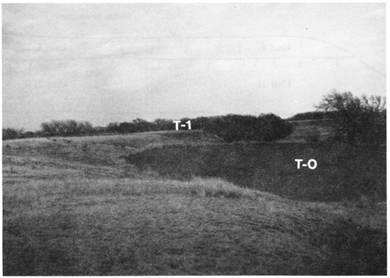
Locality PR-7 is situated in the Pawnee River valley, 80 km (50 mi) upstream from the confluence of that river with the Arkansas River (fig. 16). The Pawnee River is a fifth-order stream and has a gradient of 2.1 m/km (11 ft/mi) at this locality. The valley floor is 3.6 km (2.2 mi) wide and is composed of four landforms: a modern floodplain (T-0), a low terrace (T-1), an intermediate terrace (T-2), and a high terrace (T-3) (fig. 37). The T-0 surface is 20-50 m (66-160 ft) wide and is separated from the T-1 surface by a steep 5-m-high (16-ft-high) scarp (fig. 38). T-1 is a paired terrace, and its broad, flat surface composes most of the valley floor (fig. 37). Remnants of the T-2 terrace occur on both sides of the valley floor in the western half of locality PR-7. Where the T-2 terrace is preserved, its surface is separated from the T-1 terrace by a 2-m-high (7-ft-high) scarp. Also, a 2-m-high (7-ft-high) scarp separates the T- 2 terrace from the T-3 terrace where both terraces occur. Remnants of the T-3 terrace are scattered along the margins of the valley floor (fig. 37).
Figure 37--Landform map of locality PR-7 showing the location of the McCreight section.
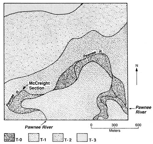
Figure 38--The scarp separating the T-1 and T-0 surfaces at locality PR-7.
A 9.9-m-thick (32-ft-thick) section of T-1 fill is exposed in a steep cutbank along the Pawnee River at locality PR-7 (fig. 39). This cutbank, referred to as the McCreight section, is described in appendix table A.9, and two soil samples were collected for radiocarbon dating.
Figure 39--McCreight section.

Six stratigraphic units and five buried soils have been identified in the McCreight section (fig. 40). The lowest stratigraphic unit (unit VI) is at least 2.07 m (6.79 ft) thick and is composed of calcareous fine-grained alluvium. A paleosol (soil 6) with Ak-Bk-Ck horizonation is developed at the top of unit VI (figs. 40 and 41). The 6Akb horizon is 30 cm (0.98 ft) thick and is a brown (10YR 4/3, dry) silty clay loam. Films and threads of carbonate are common (stage I+), and the heavy texture of alluvium at the top of unit VI has imparted subangular-blocky structure within this former surface horizon.
Figure 40--Cross-sectional diagram of the McCreight section showing stratigraphic units, soils, and radiocarbon ages.
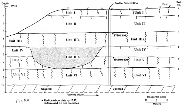
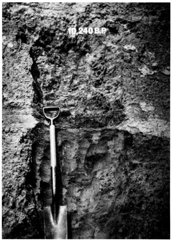
Figure 41--Soils 5 and 6 at the base of the McCreight section. Radiocarbon age determined on humates.
The 6Bkb horizon is 61 cm (2.0 ft) thick and is a brown (10YR 5/4, dry) silty clay. This horizon has medium subangular-blocky structure and many carbonate films and threads and few fine, soft carbonate masses (stage II). Films and threads of calcium carbonate (stage I+) are also present in the 6BCkb and 6Ck horizons. The 6Ck horizon consists of pale-brown (10YR 6/3, dry) stratified silty clay loam.
Unit V is 1.30 m (4.27 ft) thick and is composed of fine-grained alluvium. A paleosol (soil 5) with Ak-BkBCk horizonation is developed at the top of this unit (figs. 40 and 41). The 5Akb horizon is 55 cm (1.8 ft) thick and is a grayish-brown (10YR 5/2, dry) silty clay loam. This thick, dark buried A horizon has weak carbonate morphology (stage I), and the soil matrix is noncalcareous. As was the case with the 6Akb horizon, the 5Akb horizon has subangular-blocky structure because of the heavy texture of the alluvium. The 5Bkb horizon (5Bkb 1 + 5Bkb2) is 85 cm (2.8 ft) thick and is a brown (10YR 5/3, dry) silty clay. There are many films and threads and a few fine, hard concretions of calcium carbonate (stage II) within the 5Bkb horizon. Humates from the upper 20 cm (0.66 ft) of soi I 5 yielded a radiocarbon age of 10,240 ± 120 yr B.P.
Unit IV is 1.32 m (4.33 ft) thick and is composed of calcareous fine-grained alluvium. A paleosol (soil 4) with Ak-ACk horizonation is developed at the top of this unit. The 4Akb horizon is 55 cm (1.8 ft) thick and is a grayish-brown (10YR 5/2, dry) silt loam. There are many films and threads of calcium carbonate (stage I+), and the soil matrix is calcareous based on its strong reaction to HCl. Carbonate morphology in the 4ACkb horizon also is stage I+.
A paleochannel is cut into units IV and V (figs. 39 and 40). This channel is filled with very pale brown (10YR 7/3, dry) fine sandy loam and loamy fine sand (unit IIIb). The channel fill and unit IV are mantled by a 1.68-m-thick (5.51-ft-thick) stratum (unit IIIa) of fine-grained alluvium (fig. 40). A paleosol (soil 3) with Ak-ACk-Ck horizonation is developed at the top of unit IIIa. The 3Akb horizon is 47 cm (1.5 ft) thick and is a brown (10YR 4/3, dry) silt loam. Carbonate morphology is weak (stage I) in the 3Akb horizon but becomes better developed (stage II) in the 3ACkb horizon. Humates from the upper 20 cm (0.66 ft) of the 3Akb horizon yielded a radiocarbon age of 7,720 ± 110 yr B.P.
Unit II is 1.40 m (4.59 ft) thick and is composed of calcareous fine-grained alluvium. A paleosol (soil 2) with Ak-ACk-C horizonation is developed at the top of this unit. The 2Akb horizon is 35 cm (1.1 ft) thick and is a brown (10YR 4/3, dry) silt loam. Carbonate morphology is weak (stage I) in soil 2, and the soil matrix is moderately calcareous based on its reaction to HCl. The lower 80 cm (2.6 ft) of unit II (2C horizon) consists of stratified vertical-accretion deposits. In the 2C horizon, dark-brown strata of silty clay and silty clay loam are separated by pale-brown strata of silt loam and very fine sandy loam.
Unit I is 1.90 m (6.23 ft) thick and also is composed of calcareous fine-grained alluvium. The modern surface soil (soil 1) at the top of unit I has a moderately developed A-ABk-Bk-BCk-C profile. The A horizon is 55 cm (1.8 ft) thick and is a brown (10YR 5/3, dry) to dark-grayish-brown (10YR 4/2, dry) silt loam. No secondary carbonates were observed in the A horizon, but the soil matrix is calcareous based on its strong reaction to HCl. A few films and threads of calcium carbonate (stage I) appear in the ABk horizon, and carbonate morphology increases to stage II in the Bk horizon. The Bk horizon is 49 cm (1.6 ft) thick and is a brown (10YR 5/3, dry) silty clay loam. There is medium subangular-blocky structure in the Bk horizon, and secondary carbonates occur as films, threads, and fine soft and hard concretions (stage II). Carbonate morphology weakens in the BCk horizon and does not exceed stage I in the underlying C horizon. The C horizon is massive and is composed of calcareous silt loam.
Based on mean residence time for organic carbon from the upper 20 cm (0.66 ft) of soil 5, alluvium composing units VI and V accumulated sometime before ca. 10,200 yr B.P. The fine texture of alluvium composing these units is typical of distal floodplain deposits. Aggradation of unit VI was followed by a period of floodplain stability and soil development (soil 6). Renewed alluviation resulted in burial of soil 6 beneath vertical-accretion deposits composing unit V. The floodplain stabilized again at ca. 10,200 yr B.P., which is the radiocarbon age determined on humates from the upper 20 cm (0.66 ft) of soil 5. Soil 5 was buried by alluvium composing unit IV sometime after ca. 10,200 yr B.P. but before ca. 7,720 yr B.P. During this same period, a deep channel was cut into units IV and V, and soil 4 developed at the top of unit IV. Before ca. 7,720 yr B.P. the paleochannel was filled with sandy alluvium composing unit IIIb. Aggradation continued, and fine-grained alluvium composing unit IIIa mantled both the channel fill and soil 4. Mean residence time for organic carbon from the upper 20 cm (0.66 ft) of soil 3 indicates that aggradation of unit IIIb ceased and soil development was underway on the early Holocene floodplain by at least ca. 7,720 yr B.P. Soil 3 was buried by flood deposits composing unit II sometime after ca. 7,720 yr B.P. An episode of landscape stability resulted in the development of soil 2 at the top of unit II. Renewed alluviation and concomitant aggradation of unit I resulted in burial of soil 2. Subsequent downcutting by the Pawnee River isolated the T-1 surface from frequent floods, thereby allowing soil 1 to develop at the top of unit I. The exact timing of this downcutting event is unknown, but temporal data from other localities suggest that it occurred sometime between ca. 2,000 and 500 yr B.P.
Locality PR-8
Locality PR-8 is situated in the Pawnee River valley, 89.5 km (55.6 mi) upstream from the confluence of that river with the Arkansas River (fig. 16). The Pawnee River is a fifth-order stream and has a gradient of 2.3 m/km (12 ft/mi) at this locality. The valley floor is 2.4 km (1.5 mi) wide and is composed of four landforms: a modern floodplain (T-0), a low terrace (T-1), an intermediate terrace (T-2), and a high terrace (T-3) (fig. 42). The T-0 surface is 20-150 m (66-490 ft) wide and is separated from the T-1 surface by a steep 4-m-high (13-ft-high) scarp. T-1 is a paired terrace, and its broad, flat surface composes most of the valley floor. Remnants of the T-2 terrace occur on both sides of the valley floor in the western half of locality PR-8 but are limited to the northern side in the eastern half. Where the T-2 terrace is present, its surface is separated from the T-1 terrace by a 2-m-high (7-ft-high) scarp. Also, a 2-m-high (7-ft-high) scarp separates the T-2 and T-3 terraces where both terraces are preserved. Remnants of the T-3 terrace are scattered along the margins of the valley floor (fig. 42).
Figure 42--Landform map of locality PR-8 showing the location of the Patchen section.
Lateral migration of the Pawnee River at locality PR- 8 has created many long, steep cutbanks that expose thick sections of T-1 fill. The T-1 fill also is exposed in several deep trench silos. The stratigraphy observed in the silos and cutbanks is basically the same from one exposure to the next. A paleosol with a thick, dark A horizon is typically buried beneath about 2.5 m (8.2 ft) of loamy alluvium (figs. 43 and 44). The paleosol is developed in fine loamy sediment that grades downward into sandy stratified fill. Although no paleosols were detected below this distinct buried soil, buried soils with weakly expressed A-AC profiles are often developed in the alluvium above it.
Figure 43--T-1 fill exposed in cutbanks at locality PR-8. Note the dark buried paleosol (soil 5) in the upper portion of the fill.
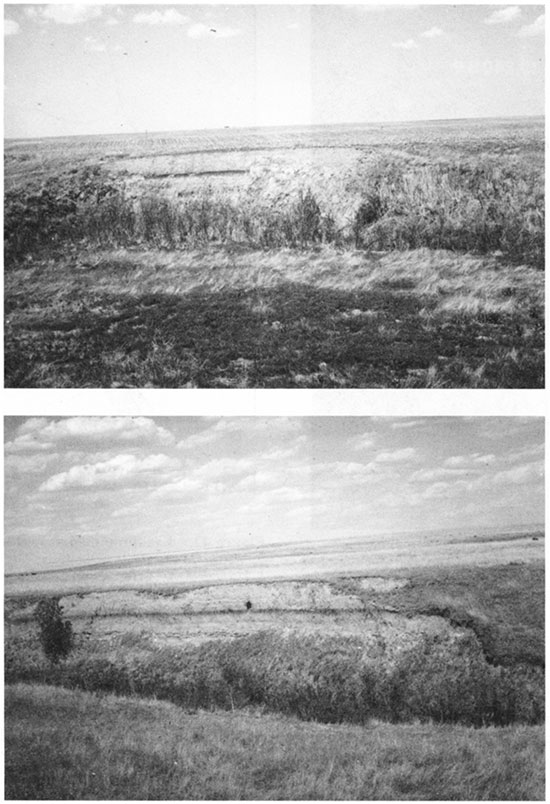
Figure 44--(A) Trench silo cut into T-1 fill. (B) Close-up of soil 5 exposed in the wall of the trench.
A representative cutbank, referred to as the Patchen section, was selected for detailed study of the T-1 fill (fig. 45). The Patchen section is described in appendix table A.10, and a soil sample was recovered for radiocarbon dating.
Figure 45--Patchen Section at locality PR-8.
Two stratigraphic units and four buried soils were identified in the Patchen section (fig. 46).The lowest stratigraphic unit (unit II) is at least 4 m (13 ft) thick. The upper 2.69 m (8.83 ft) of unit II consists of fine-grained calcareous alluvium. Below a depth of 2.69 m, however, the alluvium is sandy. Sedimentary features, including foreset crossbedding and horizontal laminae, were observed in the sandy fill. The alluvium above the stratified sand is massive and fines upward from loam to silt loam.
Figure 46--Cross-sectional diagram of the Patchen section showing stratigraphic units, buried soils, and radiocarbon age.
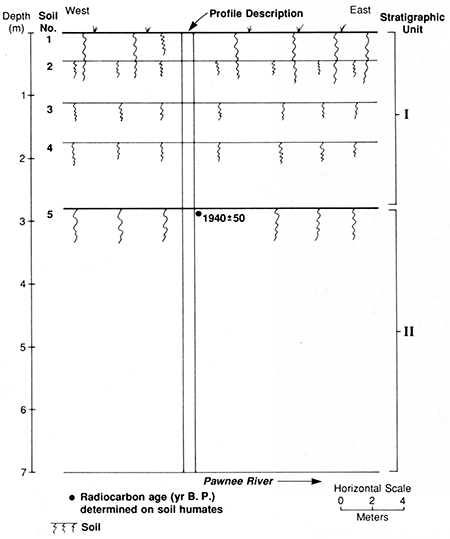
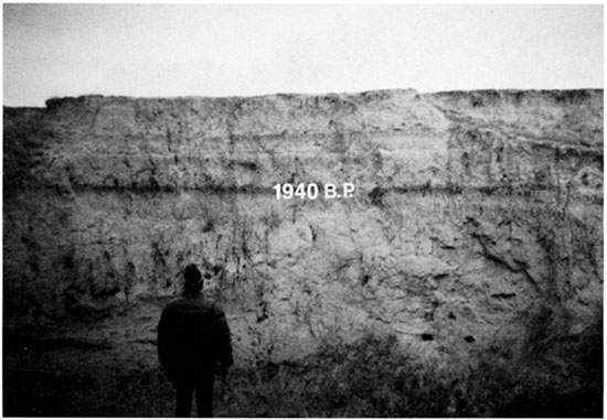
A paleosol (soil 5) with A-Bw-BCk-C horizonation is developed at the top of unit II (fig. 46). The 5Ab horizon (5Ab1 + 5Ab2) is 46 cm (1.5 ft) thick and is a darkgray (10YR 4/1, dry) to grayish-brown (10YR 5/2, dry) silt loam. No secondary carbonates were observed in the 2Ab horizon, and the soil matrix is slightly calcareous based on its weak reaction to HCl. Humates from the upper 20 cm (0.66 ft) of soil 5 yielded a radiocarbon age of 1,940 ± 60 yr B.P.
The 5Bwb horizon is 33 cm (1.1 ft) thick and is a yellowish-brown (10YR 5/4, dry) silt loam. This cambic horizon has weak, fine subangular-blocky structure. There is no evidence of secondary carbonates, but the matrix is calcareous.
Unit I is 2.51 m (8.23 ft) thick and is composed of calcareous fine-grained alluvium. Three buried paleosols (soils 2, 3, and 4) were detected in this unit (figs. 45 and 46). All these soils and the modern surface soil (soil 1) at the top of unit I have weakly developed A-AC profiles. The buried A horizons are dark brown (10YR 4/3, dry) and 20-30 cm (0.66-0.98 ft) thick.
Based on the radiocarbon age of humates from soil 5, the underlying alluvium accumulated sometime before ca. 1,900 yr B.P. The late Holocene floodplain of the Pawnee River was relatively stable by at least 1,900 yr B.P., but renewed alluviation resulted in aggradation of unit I and burial of soil 5. Accumulation of sediments composing unit I was interrupted by three episodes of landscape stability and concomitant soil formation. The thin, faint A-AC profiles of soils 2, 3, and 4 suggest that these episodes of stability were of short duration. Also, the weakly developed surface soil at the top of unit I is indicative of a short period of landscape stability. Hence the T-1 surface at locality PR-8 appears to be young.
Locality PR-9
Locality PR-9 is situated in the Pawnee River valley, 99.2 km (61.6 mi) upstream from the confluence of that river with the Arkansas River (fig. 16). The Pawnee River is a fifth-order stream and has a gradient of 2.2 m/km (12 ft/mi) at this locality. The valley floor is 3.0 km 0.9 mi) wide and is composed of four landforms: a modern floodplain (T-0), a low terrace (T-1), an intermediate terrace (T-2), and a high terrace (T-3) (fig. 47). The T-0 surface is 120 m (394 ft) wide and is separated from the T-1 surface by a steep 4-m-high (13-ft-high) scarp. T-1 is a paired terrace, and its broad, flat surface dominates the valley floor (fig. 47). Remnants of the T-2 terrace occur on both sides of the valley floor at locality PR-9 and are separated from T-1 by a 2-m-high (7-ft-high) scarp. A 2-m-high (7-ft-high) scarp also separates T-2 from T-3 where both terraces are preserved. The broad, gently sloping surface of the T-3 terrace merges with the valley walls.
Figure 47--Landform map of locality PR-9 showing the location of site 14HO5.
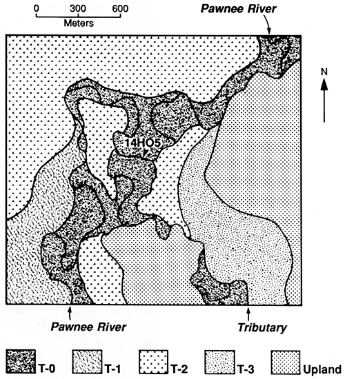
The Pawnee River has cut laterally into its modern floodplain at locality PR-9, exposing a long, 2.5-m-thick (8.2-ft-thick) section of T-0 fill. Inspection of the cutbank resulted in the discovery of numerous bones (burned and unburned), potsherds, and chert flakes at a depth of 90-125 cm (3.0-4.10 ft) below the T-0 surface. Probing with a bucket auger revealed that the cultural deposits (site 14HO5) extend far back into the T-0 fill. A portion of the cutbank is described in appendix table A.11, and several pottery fragments were collected for identification.
Two stratigraphic units and one buried soil were observed in the section at site 14HO5 (fig. 48). The lowest stratigraphic unit (unit 1I) is at least 1.6 m (5.2 ft) thick and is composed of calcareous fine-grained alluvium. A thin paleosol (soil 2) with A-AC-C horizonation is developed at the top of unit II. The 2Ab horizon is 25 cm (0.82 ft) thick and is a dark-grayish-brown (10YR 4/2, dry) silt loam. The underlying alluvium is silty, but there are thin beds of loamy and fine-sandy alluvium in the 2C horizon.
Figure 48--Cross-sectional diagram of the section at site 14HO5 showing stratigraphic units, soils, and cultural horizon.
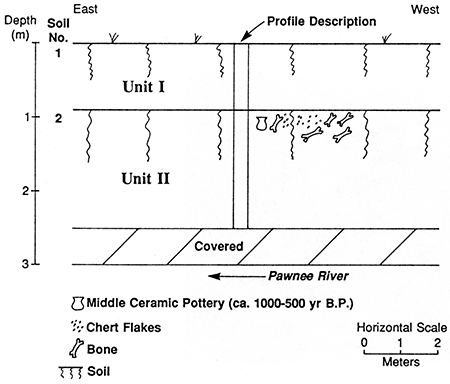
Unit I is 90 m (295 ft) thick and is composed of calcareous silt loam. The modern surface soil (soil 1) at the top of this alluvial unit is a Haplustoll with A-AC-C horizonation. The potsherds recovered from the upper 25 cm (0.82 ft) of the 2Ab horizon were identified as Middle Ceramic (Barry Williams, personal communication, 1988). The Middle Ceramic spans the period 1,000 to 500 yr B.P. Hence unit II is at least 500-1,000 years old, and unit I is less than 500 years old. In addition to providing minimum and maximum ages for stratigraphic units composing T-0 fill, temporal information from site 14HO5 sheds light on the timing of late Holocene entrenchment. Because the T-0 fill had aggraded by ca. 1,000-500 yr B.P., the Pawnee River must have deeply incised its Holocene valley fill, thereby creating the T-1 terrace, sometime before that time.
Locality PR-10
Locality PR-10 is situated in the Pawnee River valley, 115 km (71.4 mi) upstream from the confluence of that river with the Arkansas River (fig. 16). Here, the Pawnee River is a fifth-order stream with a gradient of 1.5 m/km (7.9 ft/mi). The valley floor is 3.2 km (2.0 mi) wide and is composed of three landforms: a narrow modern floodplain (T-0), a low terrace (T-1), and a high terrace (T-3) (fig. 49). The intermediate terrace (T-2) was not observed at locality PR-10.
Figure 49--Landform map of locality PR-10 showing the location of the Fearker section.
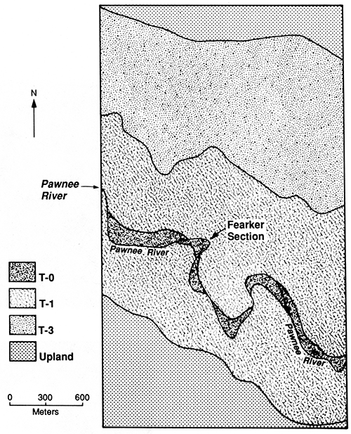
The Pawnee River has migrated laterally into the T-1 fill at several places at locality PR-10. One of the cutbanks formed by lateral erosion provided an opportunity to examine a 3.4-m-thick (11-ft-thick) section of T-1 fill (fig. 50A). This cutbank exposure, which is referred to as the Fearker section, is described in appendix table A.12, and a soil sample was collected for radiocarbon dating.
Two stratigraphic units and one buried paleosol were identified in the Fearker section (fig. 51). The lowest stratigraphic unit (unit II) is at least 1.98 m (6.50 ft) thick and is composed of calcareous fine-grained alluvium. A dark paleosol (soil 2) with Ak-Bk-BCk horizonation is developed at the top of unit II (fig. 50B). The 2Akb horizon is 53 cm (1.7 ft) thick and is a gray (10YR 5/1, dry) to grayish-brown (10YR 5/2, dry) silt loam. Carbonate threads (stage I) are common in the 2Akb horizon and extend down into the 2Bkb horizon. The 2Bkb horizon is 40 cm (1.3 ft) thick and is a brown (10YR 5/3, dry) silty clay loam. Structural development is relatively weak in the 2Bkb horizon. The underlying 2BCkb and 2Ck horizons have loamy texture, and carbonate morphology is slightly better developed (stage I+) in these horizons. Humates from the upper 20 cm (0.66 ft) of soil 2 yielded a radiocarbon age of 1,710 ± 80 yr B.P.
Figure 50--(A) Fearker section at locality PR-10. (B) Close-up of soil 2.
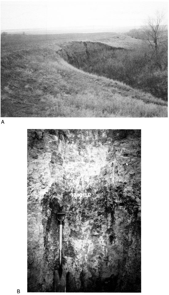
Figure 51--Cross-sectional diagram of the Fearker section showing stratigraphic units, soils, and radiocarbon age.
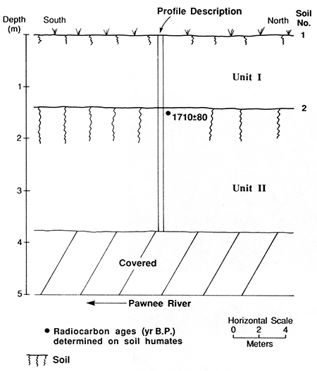
Unit I is 1.42 m (4.66 ft) thick and consists of calcareous fine-grained alluvium. Stratified fine and very fine sandy loam composing the lower 97 cm (3.2 ft) of the unit grades upward to a massive loam. The surface soil (soil 1) at the top of unit I is a Haplustoll with A-AC horizonation. The A horizon is 32 cm (1.0 ft) thick and is a brown (10YR 5/3, dry) loam. The alluvium becomes slightly coarser going from the AC to CI horizon, and thin horizontal bedding is preserved in the C1 and C2 horizons. Threads of calcium carbonate (stage I) are common in the C2 horizon and extend down into the 2Ab horizon.
Based on the age of humates from soil 2 at the top of unit II, sediment composing unit I accumulated sometime after ca. 1,700 yr B.P. Weak pedogenic alteration of alluvium in unit I suggests that it may be Historic in age. Also, the mean residence time of organic carbon from soil 2 indicates that pedogenesis was underway on the late Holocene floodplain by at least ca. 1,700 yr B.P. However, the absolute age of deposits composing unit II is unknown.
The two remaining localities along the main stem of the Pawnee River are examined in the next section. These two localities are in the extreme headwaters of the Pawnee River (fig. 16). Hence they are described as small valleys rather than as large ones.
Prev Page--Contents || Next Page--Investigations, Small Valleys
Kansas Geological Survey, Geology
Placed on web July 8, 2016; originally published 1994.
Comments to webadmin@kgs.ku.edu
The URL for this page is http://www.kgs.ku.edu/Publications/Bulletins/236/03_invest.html