![]()
Appendix One
The Preparation of Shale Specimens for X-ray Diffraction Analysis by a Suction-Onto-Membrane Filter Method
One major requirement of quantitative X-ray diffraction analysis of shale mineralogy is a simple, accurate and reproducible method of sample preparation (Gibbs, 1965, 1967, 1968, 1969; Gipson, 1966; Shaw, 1972). However, problems arise first with the tendency of the clay minerals to assume preferred orientations which cannot be accurately reproduced from sample to sample, and second with the segregation of mineral phases during the settling stage. Quantitative determination of mineral percentages in shales by X-ray diffraction must avoid both these problems, and a number of techniques for producing randomly orientated samples have been proposed, e.g., Hughes and Bohor's (1971) spray drying technique, a method employing polyester foam sheeting (Thomson, Duthie and Wilson, 1972) and others by Brindley and Kurtossy (1961), Jonas and Kuykendall (1966), Martin (1966) and Niskanen (1964). However, all these techniques were developed specifically for clay mineral studies and few are suitable for the analysis of shale samples.
A method has been developed for the quantitative mineralogical analysis of shales by X-ray diffractin using Millipore filter equipment and membrane filters (Millipore equipment is manufactured by Millipore Filter Corporation, Bedford, Massachusetts). The method has proved simple and quick to operate and the accuracy and reproducibility are very high in comparison with alternative techniques (Cubitt, 1975a). This technique has been successfully applied in the study of Upper Pennsylvanian and Lower Permian shales of Kansas.
Sample Preparation
Approximately 0.05 gm of ground shale sample (less than 60 microns) is placed in a small beaker and 20 ml of distilled water added by pipette. The materials are then agitated by sonic probe and the disaggregated shale/water mixture is placed in a Millipore filter funnel. Vacuum pressure applied to the membrane filter sucks all the liquid through the filter in 20-30 seconds, preventing orientation and segregation of minerals. The filter paper is removed from the apparatus, and taped onto a microscope slide. After drying for a few minutes, the slide-mounted filter paper can be examined by X-ray diffraction.
The Millipore filter apparatus consists of four parts--a vacuum flask, a fretted glass funnel base and filter support, a clamp, and a funnel top. A 1.2 micron opening membrane filter is placed on the filter support and a glass funnel is clamped to it. The base is then placed in the vacuum flask and secured with a rubber bung. A water pump attached to the vacuum flask provides the pressure.
Discussion
This method of preparing mounts for the X-ray diffraction analysis of shales has several advantages over alternative techniques.
- Simplicity: The system is very simple to operate and prevents the majority of human errors creeping into the mounting preparation, a failure that has dogged many sample preparation techniques.
- Speed: The simplicity of the system also ensures that the preparation time is reduced to a minimum. Ten minutes per sample seems to be an optimum operating figure.
- Accuracy and reproducibility: In comparison with standard techniques, the accuracy and reproducibility are appreciably higher. This is due to the method of particle collection on the surface of the filter paper. The rapid suction of particles onto the membrane filter obviates preferential settling and orientation. Any preponderance of non-flaky minerals in the shales will also aid the random orientation of mineral grains.
The technique was found to be suitable for large numbers of shale samples and has been successfully applied to the mineralogical analysis of the Upper Pennsylvanian and Lower Permian shales of Kansas. This technique has only one disadvantage when applied to these shales--no detailed high temperature analysis of clay minerals may be undertaken due to the nature of the mount. In this case, an alternative technique, i.e., ground dry sample molded into a pellet using a high pressure press (Hildago and Renton, 1971), may prove to be a suitable substitute. However, the value of the method lies in its speed, accuracy, simplicity, and reproducibility and as such provides a "quick look" technique for the mineralogical analysis of shales.
Appendix Two
Electron Spin Resonance Spectra of Selected Carbonates, Sulphates, and Clay Minerals
This study was conducted to establish the nature of free spin features detected in shale ESR spectra.
A number of common carbonate, sulphate, and clay minerals were chosen to represent possible constituent minerals of the Upper Pennsylvanian and Lower Permian shales of Kansas. Table 19 contains a list of these minerals, provided by Dr. R. J. King of the Geology Department, University of Leicester, with their standard chemical formulae and localities.
Small pieces of mineral were ground with a pestle and mortar and analyzed on a Varian E-3 X-band Spectrometer using the procedure described [in Electron Spin Resonance Studies]. The majority of these minerals have never been examined by ESR previously, and it is hoped that the spectra recorded in this appendix (Figures 53 to 64) will serve as reference spectra for future experimental studies on individual minerals in a similar manner to the service provided to organic chemists by the ESR spectra recorded in Bielski and Gebicki (1967).
The spectra have brief descriptions as figure captions but it was beyond the scope of this study to perform experimental work to confirm these assertions. The descriptions must therefore be considered to be suggestions rather than fact. The figures include, where necessary, references to other experimental ESR spectra on minerals.
Table 19--Common minerals representing possible constituents of Upper Pennsylvanian and Lower Permian shales of Kansas.
| Mineral Name | Chemical Formula | Mineral Locality |
|---|---|---|
| 1. Strontianite | SrCO3 | Whitesmith Mine, Strontian, Argyllshire, U.K. |
| 2. Rhodochrosite | MnCO3 | Emma Mine, Butte, Montana, U.S.A. |
| 3. Chalybite | 2(FeCO3) | Ivigtut, Greenland |
| 4. Barytes | BaSO4 | Silverband Mine, Knock, Westmoorland, U.K. |
| 5. Celestine | SrSO4 | Yate, Gloucestershire, U.K. |
| 6. Anhydrite | CaSO4 | Billingham, Durham, U.K. |
| 7. Kaolinite | Al4Si4O10(OH)8 | St. Austell, Cornwall, U.K. |
| 8. Dickite | Al4Si4O10(OH)8 | San Juanito, Chihuahua, Mexico |
| 9. Halloysite | Al4Si4O10(OH)8 | Wagon Wheel Gap, Colorado, U.S.A. |
| 10. Vermiculite | Mg3Si4O10(OH)2·xH2O | Ampandrandar, Madagascar |
| 11. Chlorite (Pennine) |
Mg5Al(AlSi3O10)(OH)8 | Traversella, Piedmont, Italy |
| 12. Illite | KAl2(AlSi3O10)(OH)2 | Morris, Illinois, U.S.A. |
| 13. Montmorillonite | Al2Si4O10(OH)2·xH2O | Clay Spur, Wyoming, U.S.A. |
Figure 53--A room-temperature ESR spectra of strontianite showing typical Mn2+ features. The Mn2+ is substituting for Sr2+ in the Sr2+CO32+ lattice. The hyperfine splitting is 100G approximately.
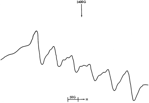
Figure 54--A room-temperature ESR spectra of rhodochrosite.
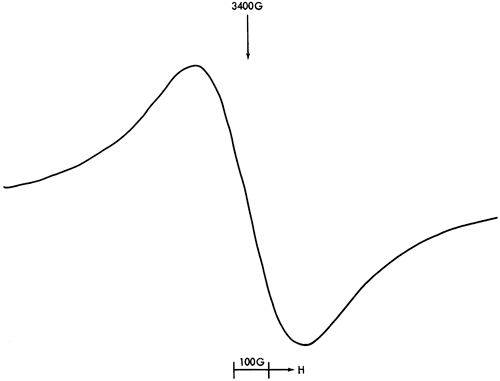
Figure 55--This spectrum is caused by Fe3+ in chalybite (2(FeCo3)). The low intensity of the Fe spectrum indicates that Fe2+ » Fe3+ (Fe2+ is not detectable by ESR).
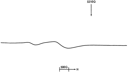
Figure 56--This spectra of barytes (BaSO4) shows little except for a free spin feature which seems to be Fe3+ replacing Ba2+ in the BaSO4 lattice. The hyperfine splitting is 1.25G approximately.
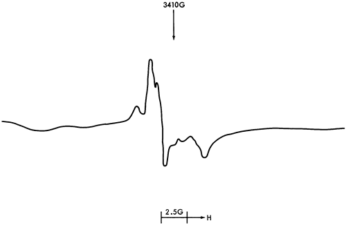
Figure 57--Celestine (SrSO4) unlike strontianite (SrCO3) shows no Mn2+ but does exhibit free spin features, the origin of which are unknown. Fe3+ may be a contributor to this spectrum. The hyperfine splitting of this feature is 3.75G.
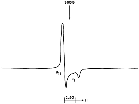
Figure 58--Mn2+ is found in anhydrite (4(CaSO4)) substituting for Ca2+ in the CaSO4 tetrahedron. A free spin feature was detected but the low peak intensity prevented accurate determination of its origin.
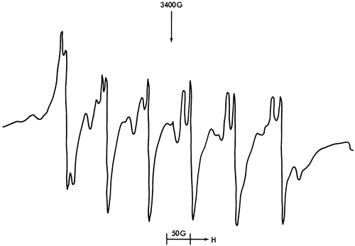
Figure 59--The asymmetric double peak of kaolinite is identical to that reported by Friedlander et al. (1963), Wauchope and Hague (1971), and Angel and Hall (1972). Angel and Hall have suggested that this may be caused by a tetrahedrally coordinated Fe3+ ion whereas Wauchope and Hague have identified it as an oxygen species.
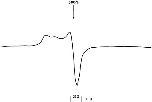
Figure 60--The dickite spectrum shows an asymmetrical peak distribution with a central peak surrounded by six less intense peaks. Its origins are entirely unknwon at present.
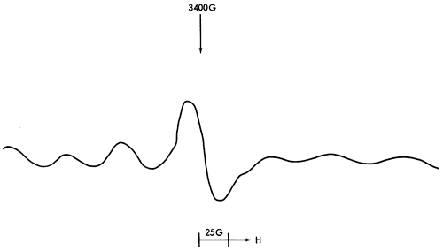
Figure 61--Halloysite produced a low field peak that is accounted for by an Fe3+ ion. Peaks in this region are found in most of the clays studied and are particularly prominent in illite and montmorillonite. The lack of a low field peak in kaolinite can be attributed to a differing site position for the Fe3+.
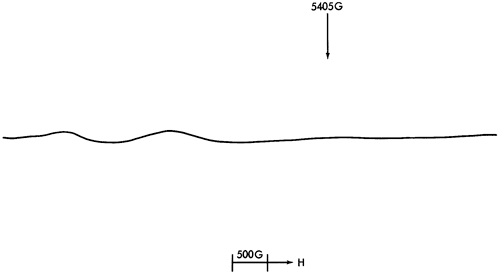
Figure 62--Vermiculite shows peaks at both 3400G and 1600G approximately. Again Fe3+, possibly in two differing sites, accounts for the peak positions.
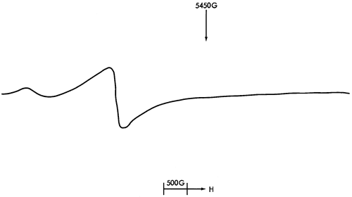
Figure 63--A most complex and unusual spectrum was produced by chlorite. This spectrum will require further study to determine the exact nature of the apramagnetic species.
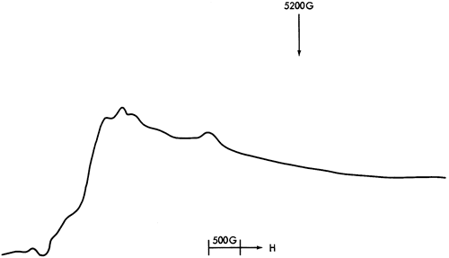
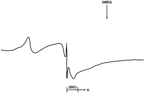
Figure 64--This spectrum of illite shows two Fe3+peaks previously identified and a set of free spin features. The Fe3+ peaks are seen at 3400G and 1600G with the free spin features at 3100G.
Appendix Three
Sample-collecting Stations
| Sample Site | Analysis | ||||||
|---|---|---|---|---|---|---|---|
| Sample | Sample Collection Station | Stratigraphical Position |
Township, Range |
Thin Section |
X.R.D. | Emiss. Spec. |
E.S.R. |
| 1 | K96 Route out of Neodesha, Wilson County |
Spring Hill Limestone |
T30S R15E | ||||
| 2 | Highway 75, Near Altoona, Wilson County |
Vilas Shale |
T29S R16E | ||||
| 3 | Highway 75, Near Altoona, Wilson County |
Vilas Shale |
T29S R16E | 1 | 1 | ||
| 4 | Highway 75, Near Altoona, Wilson County |
Vilas Shale |
T29S R16E | ||||
| 5 | Highway 75, Near Altoona, Wilson County |
Vilas Shale |
T29S R16E | 1 | 1 | 1 | |
| 7 | Highway 59, 3 Miles west of Stark, Neosho County |
Stark Shale |
SE Corner SE SE Sect. 15, T27S R20E |
1 | 1 | ||
| 10 | Intersection Highways, 52/31/59 W of Kincaid, Anderson County |
Lane, Bonner Springs Shale |
S line, SE SE Sect. 35, T22S R20E |
1 | |||
| 11 | Intersection Highways, 52/31/59 W of Kincaid, Anderson County |
Lane, Bonner Springs Shale |
S line, SE SE Sect. 35, T22S R20E |
1 | |||
| 12 | Intersection Highways, 52/31/59 W of Kincaid, Anderson County |
Lane, Bonner Springs Shale |
S line, SE SE Sect. 35, T22S R20E |
1 | 1 | ||
| 13 | 1/4 mi. S. of Intersection 52/31/59 on Highway 52/59, Anderson County |
Lane, Bonner Springs Shale |
W line NE NE Sect. 2 T23S R20E |
||||
| 14 | 1/4 mi. S. of Intersection 52/31/59 on Highway 52/59, Anderson County |
Lane, Bonner Springs Shale |
W line NE NE Sect. 2 T23S R20E |
||||
| 15 | 1/4 mi. S. of Intersection 52/31/59 on Highway 52/59, Anderson County |
Hickory Creek Shale |
W line NE NE Sect. 2 T23S R20E |
1 | 1 | ||
| 16 | Route 52, 2-3 miles SW of Mound City, Linn County |
Tacket Formation |
SW Corner NE SE Sect. 23 T22S R23E |
2 | 1 | 1 | 1 |
| 17 | Route 52, 2-3 miles SW of Mound City, Linn County |
Tacket Formation |
SW Corner NE SE Sect. 23 T22S R23E |
2 | |||
| 18 | Route 52, 2-3 miles SW of Mound City, Linn County |
Tacket Formation |
SW Corner NE SE Sect. 23 T22S R23E |
2 | |||
| 19 | Route 52, 2-3 miles SW of Mound City, Linn County |
Mound City Shale |
SW Corner NE SE Sect. 23 T22S R23E |
2 | 1 | 1 | |
| 20 | Route 52, 2-3 miles SW of Mound City, Linn County |
Mound City Shale |
SW Corner NE SE Sect. 23 T22S R23E |
1 | 1 | 1 | |
| 21 | Route 52, 2-3 miles SW of Mound City, Linn County |
Sniabar Limestone |
SW Corner NE SE Sect. 23 T22S R23E |
1 | 1 | ||
| 22 | Route 52, 2-3 miles SW of Mound City, Linn County |
Ladore Shale |
SW Corner NE SE Sect. 23 T22S R23E |
2 | |||
| 23 | Route 52, 2-3 miles SW of Mound City, Linn County |
Ladore Shale |
SW Corner NE SE Sect. 23 T22S R23E |
1 | 1 | 1 | 1 |
| 24 | Route 52, 2-3 miles SW of Mound City, Linn County |
Hushpuckney Shale |
SW Corner NE SE Sect. 23 T22S R23E |
2 | 1 | 1 | 1 |
| 25 | Route 52, 2-3 miles SW of Mound City, Linn County |
Hushpuckney Shale |
SW Corner NE SE Sect. 23 T22S R23E |
1 | 1 | ||
| 26 | Route 52, 2-3 miles SW of Mound City, Linn County |
Hushpuckney Shale |
SW Corner NE SE Sect. 23 T22S R23E |
1 | 1 | ||
| 27 | Cold Storage plant on Inland Drive, Nr. Kansas City, Johnson County |
Galesburg Shale |
T12S R23-24E | 2 | 1 | 1 | 1 |
| 28 | Cold Storage plant on Inland Drive, Nr. Kansas City, Johnson County |
Galesburg Shale |
T12S R23-24E | 1 | 1 | 1 | |
| 29 | Cold Storage plant on Inland Drive, Nr. Kansas City, Johnson County |
Stark Shale |
T12S R23-24E | ||||
| 30 | Cold Storage plant on Inland Drive, Nr. Kansas City, Johnson County |
Stark Shale |
T12S R23-24E | 2 | |||
| 31 | Cold Storage plant on Inland Drive, Nr. Kansas City, Johnson County |
Stark Shale |
T12S R23-24E | 2 | 1 | 1 | |
| 32 | Cold Storage plant on Inland Drive, Nr. Kansas City, Johnson County |
Stark Shale |
T12S R23-24E | 2 | 1 | 1 | |
| 33 | Cold Storage plant on Inland Drive, Nr. Kansas City, Johnson County |
Winterset Limestone |
T12S R23-24E | ||||
| 34 | Cold Storage plant on Inland Drive, Nr. Kansas City, Johnson County |
Winterset Limestone |
T12S R23-24E | 1 | 1 | ||
| 35 | Cold Storage plant on Inland Drive, Nr. Kansas City, Johnson County |
Winterset Limestone |
T12S R23-24E | 2 | 1 | 1 | |
| 36 | Cold Storage plant on Inland Drive, Nr. Kansas City, Johnson County |
Winterset Limestone |
T12S R23-24E | 2 | 1 | 1 | 1 |
| 37 | Cold Storage plant on Inland Drive, Nr. Kansas City, Johnson County |
Winterset Limestone |
T12S R23-24E | 2 | |||
| 38 | Cold Storage plant on Inland Drive, Nr. Kansas City, Johnson County |
Fontana Shale |
T12S R23-24E | 1 | 1 | ||
| 39 | Cold Storage plant on Inland Drive, Nr. Kansas City, Johnson County |
Wea Shale | T12S R23-24E | 2 | |||
| 40 | Cold Storage plant on Inland Drive, Nr. Kansas City, Johnson County |
Wea Shale | T12S R23-24E | 1 | 1 | ||
| 41 | Cold Storage plant on Inland Drive, Nr. Kansas City, Johnson County |
Westerville Limestone |
T12S R23-24E | 1 | 1 | ||
| 42 | 1/4 mile from Cold Storage Plant on Inland Drive, towards Kansas City, Johnson County |
Quivira Shale |
T12S R23-24E | 2 | |||
| 43 | 1/4 mile from Cold Storage Plant on Inland Drive, towards Kansas City, Johnson County |
Quivira Shale |
T12S R23-24E | 2 | 1 | 1 | 1 |
| 44 | 1/4 mile from Cold Storage Plant on Inland Drive, towards Kansas City, Johnson County |
Quivira Shale |
T12S R23-24E | 2 | |||
| 45 | 1/4 mile from Cold Storage Plant on Inland Drive, towards Kansas City, Johnson County |
Quivira Shale |
T12S R23-24E | 2 | |||
| 46 | 1/4 mile from Cold Storage Plant on Inland Drive, towards Kansas City, Johnson County |
Quivira Shale |
T12S R23-24E | 1 | 1 | 1 | |
| 47 | 1/4 mile from Cold Storage Plant on Inland Drive, towards Kansas City, Johnson County |
Chanute Shale | T12S R23-24E | 2 | 1 | 1 | |
| 48 | 1/4 mile from Cold Storage Plant on Inland Drive, towards Kansas City, Johnson County |
Chanute Shale | T12S R23-24E | 2 | 1 | 1 | 1 |
| 49 | 1/4 mile from Cold Storage Plant on Inland Drive, towards Kansas City, Johnson County |
Chanute Shale | T12S R23-24E | ||||
| 50 | 1/4 mile from Cold Storage Plant on Inland Drive, towards Kansas City, Johnson County |
Chanute Shale | T12S R23-24E | 1 | 1 | ||
| 51 | 1/4 mile from Cold Storage Plant on Inland Drive, towards Kansas City, Johnson County |
Muncie Creek Shale |
T12S R23-24E | ||||
| 51C | 1/4 mile from Cold Storage Plant on Inland Drive, towards Kansas City, Johnson County |
Muncie Creek Shale |
T12S R23-24E | 2 | |||
| 52 | 1/4 mile from Cold Storage Plant on Inland Drive, towards Kansas City, Johnson County |
Muncie Creek Shale |
T12S R23-24E | ||||
| 53 | 1/4 mile from Cold Storage Plant on Inland Drive, towards Kansas City, Johnson County |
Muncie Creek Shale |
T12S R23-24E | 1 | 1 | ||
| 54 | Highway 10, 2 1/2 mls. E of Zarah, Johnson County |
Chanute Shale | N side SE NE Sect. 14 T12S R23E |
2 | 1 | 1 | |
| 55 | Highway 10, 2 1/2 mls. E of Zarah, Johnson County |
Muncie Creek Shale |
N side SE NE Sect. 14 T12S R23E |
2 | |||
| 56 | Highway 10, 2 1/2 mls. E of Zarah, Johnson County |
Muncie Creek Shale |
N side SE NE Sect. 14 T12S R23E |
2 | |||
| 57 | Highway 10, 3 mls. E of Zarah, Johnson County |
Island Creek Shale |
N side SE NE Sect. 14 T12S R23E |
||||
| 58 | Highway 10, 3 mls. E of Zarah, Johnson County |
Island Creek Shale |
N side SE NE Sect. 14 T12S R23E |
2 | |||
| 59 | Highway 10, 3 mls. E of Zarah, Johnson County |
Farley Limestone |
N side SE NE Sect. 14 T12S R23E |
||||
| 60 | Highway 10, 3 mls. E of Zarah, Johnson County |
Farley Limestone |
N side SE NE Sect. 14 T12S R23E |
2 | |||
| 61A | Highway 10, 3 mls. E of Zarah, Johnson County |
Farley Limestone |
N side SE NE Sect. 14 T12S R23E |
1 | 1 | ||
| 61B | Highway 10, 3 mls. E of Zarah, Johnson County |
Bonner Springs Shale |
S side NE NE Sect. 13 T12S R23E |
||||
| 62 | Highway 10, 3 mls. E of Zarah, Johnson County |
Bonner Springs Shale |
S side NE NE Sect. 13 T12S R23E |
||||
| 63 | Highway 10, 3 mls. E of Zarah, Johnson County |
Bonner Springs Shale |
S side NE NE Sect. 13 T12S R23E |
1 | 1 | ||
| 64 | Highway 10, 3 mls. E of Zarah, Johnson County |
Bonner Springs Shale |
S side NE NE Sect. 13 T12S R23E |
||||
| 65 | Highway 10, 3 mls. E of Zarah, Johnson County |
Plattsburg Limestone |
S side NE NE Sect. 13 T12S R23E |
||||
| 66 | Highway 10, 3 mls. E of Zarah, Johnson County |
Plattsburg Limestone |
S side NE NE Sect. 13 T12S R23E |
2 | 1 | 1 | |
| 67 | Highway 10, 3 mls. E of Zarah, Johnson County |
Plattsburg Limestone |
S side NE NE Sect. 13 T12S R23E |
1 | 1 | ||
| 69 | K32, E of intersection with K7, Wyandotte County |
Lane Shale | W side SE SE Sect. 28 T11S R23E |
1 | 1 | 1 | 1 |
| 70 | K32, E of intersection with K7, Wyandotte County |
Lane Shale | W side SE SE Sect. 28 T11S R23E |
2 | 1 | 1 | 1 |
| 71 | K32, E of intersection with K7, Wyandotte County |
Lane Shale | W side SE SE Sect. 28 T11S R23E |
1 | 1 | ||
| 72 | Highway 10, 3 mls. E of Zarah, Johnson County |
Bonner Springs Shale |
E side NE NE Sect. 13 T12S R23E |
2 | |||
| 73 | Kerford Quarry, 1 ml. S of Atchison on Highway 7, Atchison County |
Heumader Shale |
Center SW SE Sect. 7 T6S R21E |
1 | |||
| 74 | Kerford Quarry, 1 ml. S of Atchison on Highway 7, Atchison County |
Heumader Shale |
Center SW SE Sect. 7 T6S R21E |
2 | |||
| 75 | Kerford Quarry, 1 ml. S of Atchison on Highway 7, Atchison County |
Heumader Shale |
Center SW SE Sect. 7 T6S R21E |
3 | |||
| 76 | Kerford Quarry, 1 ml. S of Atchison on Highway 7, Atchison County |
Heumader Shale |
Center SW SE Sect. 7 T6S R21E |
||||
| 77 | Kerford Quarry, 1 ml. S of Atchison on Highway 7, Atchison County |
Heumader Shale |
Center SW SE Sect. 7 T6S R21E |
2 | |||
| 78 | Kerford Quarry, 1 ml. S of Atchison on Highway 7, Atchison County |
Heumader Shale |
Center SW SE Sect. 7 T6S R21E |
||||
| 79 | Kerford Quarry, 1 ml. S of Atchison on Highway 7, Atchison County |
Heumader Shale |
Center SW SE Sect. 7 T6S R21E |
1 | 1 | ||
| 80 | Kerford Quarry, 1 ml. S of Atchison on Highway 7, Atchison County |
Jackson Park Shale |
Center SW SE Sect. 7 T6S R21E |
1 | 1 | ||
| 81 | 5 1/2 mls. E of Doniphan, Atchison County |
Stull Shale | Center SW SE Sect. 7 T6S R21E |
1 | 1 | 1 | |
| 82 | 5 1/2 mls. E of Doniphan, Atchison County |
Jackson Park Shale |
Center SW SE Sect. 7 T6S R21E |
1 | 1 | 1 | |
| 83 | 5 1/2 mls. E of Doniphan, Atchison County |
Stull Shale | Center SW SE Sect. 7 T6S R21E |
1 | |||
| 84 | 5 1/2 mls. E of Doniphan, Atchison County |
Stull Shale | Center SW SE Sect. 7 T6S R21E |
2 | |||
| 85 | 5 1/2 mls. E of Doniphan, Atchison County |
Stull Shale | Center SW SE Sect. 7 T6S R21E |
1 | 1 | 1 | |
| 86 | 5 1/2 mls. E of Doniphan, Atchison County |
Stull Shale | T5S R20E | ||||
| 87 | 5 1/2 mls. E of Doniphan, Atchison County |
Spring Branch Limestone |
T5S R20E | ||||
| 88 | 5 1/2 mls. E of Doniphan, Atchison County |
Spring Branch Limestone |
T5S R20E | ||||
| 89 | 5 1/2 mls. E of Doniphan, Atchison County |
Doniphan Shale |
T5S R20E | ||||
| 90 | 5 1/2 mls. E of Doniphan, Atchison County |
Doniphan Shale |
T5S R20E | ||||
| 91 | 5 1/2 mls. E of Doniphan, Atchison County |
Doniphan Shale |
T5S R20E | 2 | |||
| 92 | 5 1/2 mls. E of Doniphan, Atchison County |
Queen Hill Shale |
T5S R20E | 1 | |||
| 93 | 5 1/2 mls. E of Doniphan, Atchison County |
Queen Hill Shale |
T5S R20E | ||||
| 94 | Quarry, 4 mls. NE of Lancaster, Atchison County |
Calhoun Shale |
NW SW Sect. 11 T5S R19E |
1 | 1 | 1 | 1 |
| 95 | Quarry, 4 mls. NE of Lancaster, Atchison County |
Calhoun Shale |
NW SW Sect. 11 T5S R19E |
2 | |||
| 96 | Quarry, 4 mls. NE of Lancaster, Atchison County |
Calhoun Shale |
NW SW Sect. 11 T5S R19E |
2 | 1 | 1 | |
| 97 | Quarry, 4 mls. NE of Lancaster, Atchison County |
Calhoun Shale |
NW SW Sect. 11 T5S R19E |
2 | 1 | 1 | |
| 97B | Road alongside quarry, 4 mls. NE of Lancaster, Atchison County |
Turner Creek Shale |
NW SW Sect. 11 T5S R19E |
1 | 1 | ||
| 98 | Road alongside quarry, 4 mls. NE of Lancaster, Atchison County |
Jones Point Shale |
NW SW Sect. 11 T5S R19E |
||||
| 99 | Road alongside quarry, 4 mls. NE of Lancaster, Atchison County |
Jones Point Shale |
NW SW Sect. 11 T5S R19E |
||||
| 100 | Road alongside quarry, 4 mls. NE of Lancaster, Atchison County |
Iowa Point Shale |
NW SW Sect. 11 T5S R19E |
||||
| 101 | Road alongside quarry, 4 mls. NE of Lancaster, Atchison County |
Iowa Point Shale |
NW SW Sect. 11 T5S R19E |
1 | 1 | ||
| 102 | Road alongside quarry, 4 mls. NE of Lancaster, Atchison County |
Tecumseh Shale |
NW SW Sect. 11 T5S R19E |
2 | |||
| 103 | Road alongside quarry, 4 mls. NE of Lancaster, Atchison County |
Tecumseh Shale |
NW SW Sect. 11 T5S R19E |
2 | |||
| 104 | Road alongside quarry, 4 mls. NE of Lancaster, Atchison County |
Tecumseh Shale |
NW SW Sect. 11 T5S R19E |
1 | |||
| 105 | Roadside 4 mls. NE of Lancaster, Atchison County |
Oskaloosa Shale |
Center of S side SW Sect. 10 T5S R19E |
2 | 1 | 1 | 1 |
| 106 | Roadside 4 mls. NE of Lancaster, Atchison County |
Oskaloosa Shale |
Center of S side SW Sect. 10 T5S R19E |
1 | |||
| 107 | Roadside 4 mls. NE of Lancaster, Atchison County |
Larsh & Burroak Shale |
Center of S side SW Sect. 10 T5S R19E |
1 | 1 | ||
| 108 | Roadside 4 mls. NE of Lancaster, Atchison County |
Larsh & Burroak Shale |
Center of S side SW Sect. 10 T5S R19E |
||||
| 109 | Roadside 4 1/2 mls. NE of Lancaster, Atchison County |
Ervine Creek Limestone |
Center of E half NE Sect. 11 T5S R19E |
1 | 1 | 1 | |
| 110 | Quarry SE of Burlington, Coffey County |
Snyderville Shale |
Center NW NW Sect. 31 T21S R16E |
1 | 1 | 1 | |
| 111 | Intersection of Highways 75/57, Coffey County |
Snyderville Shale |
SW Corner SW SW Sect. 35 T22S R15E |
2 | |||
| 112 | Intersection of Highways 75/57, Coffey County |
Snyderville Shale |
SW Corner SW SW Sect. 35 T22S R15E |
1 | 1 | ||
| 113 | Intersection of Highways 75/57, Coffey County |
Snyderville Shale |
SW Corner SW SW Sect. 35 T22S R15E |
2 | |||
| 114 | Intersection of Highways 75/57, Coffey County |
Snyderville Shale |
SW Corner SW SW Sect. 35 T22S R15E |
2 | |||
| 115 | Intersection of Highways 75/57, Coffey County |
Snyderville Shale |
SW Corner SW SW Sect. 35 T22S R15E |
||||
| 116 | 100 yds. N of intersection of 75/57, Coffey County |
Toronto Limestone |
W side SW SW Sect. 35 T22S R15E |
1 | 1 | ||
| 117 | Intersection of Highways 75/57, Coffey County |
Snyderville Shale |
SW Corner SW SW Sect. 35 T22S R19E |
||||
| 118 | Intersection of Highways 75/57, Coffey County |
Snyderville Shale |
SW Corner SW SW Sect. 35 T22S R19E |
||||
| 119 | 2 1/2 mls. NE of Gridley, Coffey County |
King Hill Shale |
West Line SW NW Sect. 14 T22S R14E |
||||
| 120 | 2 1/2 mls. NE of Gridley, Coffey County |
Beil Limestone |
West Line SW NW Sect. 14 T22S R14E |
||||
| 121 | 3 mls. NE of Gridley, Coffey County |
Doniphan Shale |
E line NE Sect. 24, T22S R14E |
2 | 1 | 1 | |
| 122 | Quarry 9 1/2 mls. W of Burlington, Coffey County |
Jones Point Shale |
Center NE NW Sect. 30 T21S R14E |
1 | 1 | 1 | |
| 124 | Highway 70, 3 1/2 mls. E of Big Springs, Douglas County |
Snyderville Shale |
NW Corner Sect. 21 T12S R18E |
||||
| 125 | Highway 70, 3 1/2 mls. E of Big Springs, Douglas County |
Lawrence Shale |
NW Corner Sect. 21 T12S R18E |
1 | 1 | 1 | |
| 126 | Highway 70, 3 1/2 mls. E of Big Springs, Douglas County |
Snyderville Shale |
NW Corner Sect. 21 T12S R18E |
||||
| 127 | Highway 70, 3 1/2 mls. E of Big Springs, Douglas County |
Snyderville Shale |
NW Corner Sect. 21 T12S R18E |
1 | |||
| 128 | Highway 70, 3 1/2 mls. E of Big Springs, Douglas County |
Heebner Shale |
NW Corner Sect. 21 T12S R18E |
3 | 1 | 1 | |
| 129 | Highway 70, 3 1/2 mls. E of Big Springs, Douglas County |
Heebner Shale |
NW Corner Sect. 21 T12S R18E |
||||
| 130 | Highway 70, 3 1/2 mls. E of Big Springs, Douglas County |
Heebner Shale |
NW Corner Sect. 21 T12S R18E |
1 | 1 | ||
| 131 | Highway 70, 3 1/2 mls. E of Big Springs, Douglas County |
Heebner Shale |
NW Corner Sect. 21 T12S R18E |
||||
| 132 | Highway 70, 3 1/2 mls. E of Big Springs, Douglas County |
Heumader Shale |
NW Corner Sect. 21 T12S R18E |
1 | |||
| 133 | Highway 70, 5 mls. W of Lawrence, Douglas County |
Spring Branch Limestone |
NW NW Sect. 19 T12S R19E |
1 | |||
| 134 | Highway 70, 5 mls. W of Lawrence, Douglas County |
Spring Branch Limestone |
NW NW Sect. 19 T12S R19E |
1 | |||
| 135 | Highway 70, 5 mls. W of Lawrence, Douglas County |
Spring Branch Limestone |
NW NW Sect. 19 T12S R19E |
1 | 1 | 1 | 1 |
| 136 | Highway 70, 5 1/2 mls. W of Lawrence, Douglas County |
Queen Hill Shale |
NE NE Sect. 24 T12S R18E |
1 | 1 | 1 | |
| 137 | Highway 70, 5 1/2 mls. W of Lawrence, Douglas County |
Beil Limestone |
NE NE Sect. 24 T12S R18E |
1 | 1 | 1 | 1 |
| 138 | Highway 70, 5 mls. W of Lawrence, Douglas County |
Doniphan Shale |
NW NW Sect. 19 T12S R19E |
1 | 1 | ||
| 139 | Highway 70, 7 1/2 mls. W of Lawrence, Douglas County |
Oskaloosa Shale |
NE NW Sect. 22 T12S R18E |
1 | |||
| 140 | Highway 70, 7 1/2 mls. W of Lawrence, Douglas County |
Oskaloosa Shale |
NE NW Sect. 22 T12S R18E |
2 | |||
| 141 | Highway 70, 7 1/2 mls. W of Lawrence, Douglas County |
Oskaloosa Shale |
NE NW Sect. 22 T12S R18E |
1 | |||
| 142 | Highway 70, 7 1/2 mls. W of Lawrence, Douglas County |
Larsh and Burroak Shale |
NE NW Sect. 22 T12S R18E |
||||
| 143A | Highway 70, 4 mls. E of Topeka, Shawnee County |
Larsh and Burroak Shale |
SE NE Sect. 8 T12S R17E |
||||
| 143B | Highway 70/40 intersection in Topeka, Shawnee County |
Iowa Point Shale |
Center NW SE Sect. 4 T12S R16E |
||||
| 144 | Highway 70/40 intersection in Topeka, Shawnee County |
Calhoun Shale |
Center NW SE Sect. 4 T12S R16E |
3 | 1 | 1 | |
| 145 | Highway 70/40 intersection in Topeka, Shawnee County |
Calhoun Shale |
Center NW SE Sect. 4 T12S R16E |
2 | |||
| 146 | Highway 70/40 intersection in Topeka, Shawnee County |
Jones Point Shale |
Center NW SE Sect. 4 T12S R16E |
2 | |||
| 148 | Highway 24, 1/2 ml. W of intersection with Highway 4, Shawnee County |
Holt Shale | S of Center Sect. 14 T11S R16E |
1 | 1 | ||
| 149 | Roadside 7 mls. W of Lawrence, Douglas County |
King Hill Shale |
S line SW SW Sect. 13 T12S R18E |
2 | 1 | 1 | |
| 150 | Roadside 7 mls. W of Lawrence, Douglas County |
Avoca Limestone |
S line SW SW Sect. 13 T12S R18E |
1 | 1 | 1 | |
| 151 | Lecompton Quarry, Douglas County |
Heumader Shale |
Center SW SW Sect. 35 T11S R18E |
2 | 1 | 1 | |
| 152 | Highway 7, 3 1/2 mls. N of Atchison, Atchison County |
Tecumseh Shale |
W side SW SW Sect. 12 T5S R20E |
1 | 1 | ||
| 153 | Highway 7, 3 1/2 mls. N of Atchison, Atchison County |
Tecumseh Shale |
W side SW SW Sect. 12 T5S R20E |
2 | 1 | 1 | |
| 154 | Highway 7, 3 1/2 mls. N of Atchison, Atchison County |
Tecumseh Shale |
W side SW SW Sect. 12 T5S R20E |
||||
| 155 | Highway 7, 3 1/2 mls. N of Atchison, Atchison County |
Tecumseh Shale |
W side SW SW Sect. 12 T5S R20E |
1 | 1 | 1 | |
| 156 | Highway 70, 1 ml. W of Bonner Springs, Wyandotte County |
Eudora Shale |
Center Sect. 18 T11S R23E |
||||
| 157 | Highway 70, 1 ml. W of Bonner Springs, Wyandotte County |
Eudora Shale |
Center Sect. 18 T11S R23E |
1 | 1 | 1 | 1 |
| 158 | Highway 70, 1 ml. W of Bonner Springs, Wyandotte County |
Rock Lake Shale |
Center Sect. 18 T11S R23E |
||||
| 159 | Highway 70, 7/10 ml. E of Kansas City Toll Booth, Wyandotte County |
Quindaro Shale |
E line NE SE Sect. 9 T11S R24E |
1 | |||
| 160 | Highway 70, 7/10 ml. E of Kansas City Toll Booth, Wyandotte County |
Quindaro Shale |
E line NE SE Sect. 9 T11S R24E |
1 | 1 | 1 | |
| 161 | Highway 70, 1 ml. W of Bonner Springs, Wyandotte County |
Rock Lake Shale |
Center Sect. 18 T11S R23E |
1 | 1 | 1 | |
| 162 | Highway 470, S. Topeka, Shawnee County |
Severy Shale |
Center S side NW Sect. 19 T12S R16E |
2 | 1 | 1 | |
| 163 | Highway 470, S. Topeka, Shawnee County |
Aarde Shale | Center S side NW Sect. 19 T12S R16E |
1 | |||
| 164 | Highway 470, S. Topeka, Shawnee County |
Aarde Shale | Center S side NW Sect. 19 T12S R16E |
||||
| 165 | Highway 470, S. Topeka, Shawnee County |
Aarde Shale | Center S side NW Sect. 19 T12S R16E |
2 | |||
| 166 | Highway 470, S. Topeka, Shawnee County |
Aarde Shale | Center S side NW Sect. 19 T12S R16E |
2 | |||
| 167 | Highway 470, 4 1/2 mls. SW of Topeka, Shawnee County |
Silver Lake Shale |
SE NE SE Sect. T13S R15E 4 |
1 | |||
| 168 | Highway 470, 4 1/2 mls. SW of Topeka, Shawnee County |
Silver Lake Shale |
SE NE SE Sect. T13S R15E 4 |
1 | 1 | 1 | 1 |
| 169 | Highway 470, 4 1/2 mls. SW of Topeka, Shawnee County |
Cedar Vale Shale |
SE NE SE Sect. T13S R15E 4 |
||||
| 170 | Highway 470, 4 1/2 mls. SW of Topeka, Shawnee County |
Silver Lake Shale |
SE NE SE Sect. T13S R15E 4 |
1 | 1 | ||
| 171 | Highway 470, 5 1/2 mls. SW of Topeka, Shawnee County |
White Cloud Shale |
SE NE SW Sect. 9 T13S R15E |
1 | 1 | 1 | |
| 172 | Highway 470, 5 1/2 mls. SW of Topeka, Shawnee County |
White Cloud Shale |
SE NE SW Sect. 9 T13S R15E |
2 | |||
| 173 | Highway 470, 5 1/2 mls. SW of Topeka, Shawnee County |
White Cloud Shale |
SE NE SW Sect. 9 T13S R15E |
2 | 1 | 1 | 1 |
| 174 | Highway 470, 2 mls. SW of Auburn, Shawnee County |
Harveyville Shale |
NE SW SW Sect. 35 T13S R14E |
1 | |||
| 176 | Highway 470, 2 1/2 mls. SW of Auburn, Shawnee County |
Willard Shale |
NE SW NE Sect. 3 T14S R14E |
||||
| 177 | Highway 470, 2 1/2 mls. SW of Auburn, Shawnee County |
Willard Shale |
NE SW NE Sect. 3 T14S R14E |
2 | |||
| 178 | Highway 470, 2 1/2 mls. SW of Auburn, Shawnee County |
Willard Shale |
NE SW NE Sect. 3 T14S R14E |
2 | |||
| 179 | Highway 470, 2 1/2 mls. SW of Auburn, Shawnee County |
Willard Shale |
NE SW NE Sect. 3 T14S R14E |
2 | |||
| 180 | Highway 470, 3 mls. SW of Auburn, Shawnee County |
Willard Shale |
SW SW NE Sect. 3 T14S R14E |
2 | 1 | 1 | |
| 181 | Highway 470, 3 mls. SW of Auburn, Shawnee County |
Wamego Shale |
SW SW NE Sect. 3 T14S R14E |
1 | 1 | ||
| 182 | Highway 470, 4 mls. NE of Admire, Lyon County |
Pillsbury Shale |
SW SW NW Sect. 12 T16S R13E |
||||
| 183 | Highway 470, 4 mls. NE of Admire, Lyon County |
Pillsbury Shale |
SW SW NW Sect. 12 T16S R13E |
2 | |||
| 184A | Highway 470, 4 mls. NE of Admire, Lyon County |
Pillsbury Shale |
SW SW NW Sect. 12 T16S R13E |
2 | 1 | 1 | 1 |
| 184B | Highway 470, 4 mls. NE of Admire, Lyon County |
Pillsbury Shale |
SW SW NW Sect. 12 T16S R13E |
||||
| 185 | Highway 470, 4 mls. NE of Admire, Lyon County |
Dry Shale | SW SW NW Sect. 12 T16S R13E |
1 | 1 | ||
| 186 | Highway 470, 4 mls. NE of Admire, Lyon County |
Grandhaven Limestone |
SW SW NW Sect. 12 T16S R13E |
1 | 1 | 1 | |
| 187 | Highway 470, 4 mls. NE of Admire, Lyon County |
Friedrich Shale |
SW SW NW Sect. 12 T16S R13E |
2 | 1 | 1 | 1 |
| 188 | Highway 470, 4 mls. NE of Admire, Lyon County |
Friedrich Shale |
SW SW NW Sect. 12 T16S R13E |
2 | |||
| 190 | Highway 470, 4 mls. NE of Admire, Lyon County |
Dry Shale | SW SW NW Sect. 12 T16S R13E |
||||
| 191 | Highway 70, 2 mls. W of Topeka, Shawnee County |
Silver Lake Shale |
SW NE NW Sect. 31 T11S R15E |
||||
| 192 | Highway 70, 2 mls. W of Topeka, Shawnee County |
Silver Lake Shale |
SW NE NW Sect. 31 T11S R15E |
1 | 1 | ||
| 193 | Highway 70, 2 mls. W of Topeka, Shawnee County |
Soldier Creek Shale |
SW NE NW Sect. 31 T11S R15E |
||||
| 194 | Highway 70, 2 mls. W of Topeka, Shawnee County |
Soldier Creek Shale |
SW NE NW Sect. 31 T11S R15E |
1 | 1 | 1 | |
| 195 | Highway 70, 2 mls. W of Topeka, Shawnee County |
Soldier Creek Shale |
SW NE NW Sect. 31 T11S R15E |
||||
| 196 | Highway 70, 2 mls. S of Maple Hill, Wabaunsee County |
Pony Creek Shale |
Center S line SW Sect. 26 T11S R12E |
1 | |||
| 197 | Highway 70, 2 mls. S of Maple Hill, Wabaunsee County |
Pony Creek Shale |
Center S line SW Sect. 26 T11S R12E |
1 | 1 | ||
| 198 | Highway 70, 2 mls. S of Maple Hill, Wabaunsee County |
Pony Creek Shale |
Center S line SW Sect. 26 T11S R12E |
||||
| 199 | Highway 70, 2 mls. S of Maple Hill, Wabaunsee County |
Towle Shale | Center S line SW Sect. 26 T11S R12E |
||||
| 200 | Highway 70, 2 mls. S of Maple Hill, Wabaunsee County |
Towle Shale | Center S line SW Sect. 26 T11S R12E |
1 | 1 | 1 | |
| 201 | Highway 70, 2 1/2 mls. SW of Maple Hill, Wabaunsee County |
Hawxby Shale |
SW SW SW Sect. 27 T11S R12E |
||||
| 202 | Highway 70, 2 1/2 mls. SW of Maple Hill, Wabaunsee County |
Hawxby Shale |
SW SW SW Sect. 27 T11S R12E |
||||
| 203 | Highway 70, 2 1/2 mls. SW of Maple Hill, Wabaunsee County |
Hawxby Shale |
SW SW SW Sect. 27 T11S R12E |
||||
| 204 | Highway 70, 2 1/2 mls. SW of Maple Hill, Wabaunsee County |
West Branch Shale |
SW SW SW Sect. 27 T11S R12E |
||||
| 205 | Highway 70, 2 1/2 mls. SW of Maple Hill, Wabaunsee County |
West Branch Shale |
SW SW SW Sect. 27 T11S R12E |
1 | 1 | ||
| 206 | Highway 70, 1/2 ml. S of Paxico, Wabaunsee County |
Hamlin Shale |
SW SW SW Sect. 27 T11S R12E |
1 | 1 | ||
| 207 | Highway 70, 1/2 ml. S of Paxico, Wabaunsee County |
Hughes Creek Shale |
SE SW SE Sect. 27, T11S R11E |
||||
| 208 | Highway 70, 1/2 ml. S of Paxico, Wabaunsee County |
Hughes Creek Shale |
SE SW SE Sect. 27, T11S R11E |
1 | 1 | 1 | |
| 209 | Highway 70, 1/2 ml. S of Paxico, Wabaunsee County |
Hughes Creek Shale |
SE SW SE Sect. 27, T11S R11E |
1 | 1 | 1 | |
| 211 | Highway 70, 3 mls. N of Alma, Wabaunsee County |
Roca Shale | Center W side Sect. 26 T11S R10E |
||||
| 212 | Highway 70, 3 mls. N of Alma, Wabaunsee County |
Legion Shale |
Center W side Sect. 26 T11S R10E |
1 | 1 | ||
| 213 | Highway 70, 3 mls. N of Alma, Wabaunsee County |
Salem Point Shale |
Center W side Sect. 26 T11S R10E |
1 | 1 | 1 | |
| 214 | Highway 70, 1/2 ml. S of Paxico, Wabaunsee County |
Hamlin Shale |
SE SW SE Sect. 27 T11S R11E |
||||
| 220 | Highway 70, 3 mls. NW of Alma, Wabaunsee County |
Speiser Shale |
S line SE NW Sect. 29 T11S R10E |
1 | 1 | 1 | |
| 221 | Highway 70, 3 mls. NW of Alma, Wabaunsee County |
Speiser Shale |
S line SE NW Sect. 29 T11S R10E |
1 | 1 | 1 | 1 |
| 222 | Highway 70, 3 mls. NW of Alma, Wabaunsee County |
Speiser Shale |
S line SE NW Sect. 29 T11S R10E |
2 | 1 | 1 | |
| 223 | Highway 70, 3 mls. NW of Alma, Wabaunsee County |
Speiser Shale |
S line SE NW Sect. 29 T11S R10E |
||||
| 225 | Highway 70, 3 1/2 mls. NW of Alma, Wabaunsee County |
Blue Rapids Shale |
SE SE NE Sect. 30 T11S R10E |
||||
| 226 | Highway 70, 3 1/2 mls. NW of Alma, Wabaunsee County |
Blue Rapids Shale |
SE SE NE Sect. 30 T11S R10E |
1 | 1 | ||
| 227 | Highway 70, 3 1/2 mls. NW of Alma, Wabaunsee County |
Blue Rapids Shale |
SE SE NE Sect. 30 T11S R10E |
1 | 1 | ||
| 228 | Highway 70, 3 1/2 mls. NW of Alma, Wabaunsee County |
Blue Rapids Shale |
SE SE NE Sect. 30 T11S R10E |
2 | |||
| 229 | Highway 70, 3 1/2 mls. NW of Alma, Wabaunsee County |
Blue Rapids Shale |
SE SE NE Sect. 30 T11S R10E |
1 | |||
| 230 | Highway 70, 4 mls. NW of Alma, Wabaunsee County |
Easly Creek Shale |
S line SW NE Sect. 30 T11S R10E |
1 | 1 | 1 | |
| 231 | Highway 70, 4 mls. NW of Alma, Wabaunsee County |
Easly Creek Shale |
S line SW NE Sect. 30 T11S R10E |
||||
| 232 | Highway 70, 4 mls. NW of Alma, Wabaunsee County |
Easly Creek Shale |
S line SW NE Sect. 30 T11S R10E |
||||
| 233 | Highway 70, 4 mls. NW of Alma, Wabaunsee County |
Easly Creek Shale |
S line SW NE Sect. 30 T11S R10E |
2 | |||
| 234 | Highway 70, 4 mls. NW of Alma, Wabaunsee County |
Hooser Shale |
S line SW NE Sect. 30 T11S R10E |
1 | 1 | 1 | |
| 235 | Highway 70, 4 1/2 mls. NW of Alma, Wabaunsee County |
Eskridge Shale |
W line NE SW Sect. 30 T11S R11E |
1 | 1 | 1 | 1 |
| 236 | Highway 70, 4 1/2 mls. NW of Alma, Wabaunsee County |
Eskridge Shale |
W line NE SW Sect. 30 T11S R11E |
2 | |||
| 237 | Highway 70, 4 1/2 mls. NW of Alma, Wabaunsee County |
Neva Limestone |
W line NE SW Sect. 30 T11S R11E |
2 | 1 | 1 | |
| 238 | Highway 70, 4 1/2 mls. NW of Alma, Wabaunsee County |
Eskridge Shale |
W line NE SW Sect. 30 T11S R11E |
1 | 1 | 1 | |
| 239 | Highway 70, 4 1/2 mls. NW of Alma, Wabaunsee County |
Eskridge Shale |
W line NE SW Sect. 30 T11S R11E |
||||
| 240 | Highway 70, 4 1/2 mls. NW of Alma, Wabaunsee County |
Eskridge Shale |
W line NE SW Sect. 30 T11S R11E |
||||
| 241 | Highway 70, 4 1/2 mls. NW of Alma, Wabaunsee County |
Neva Limestone |
W line NE SW Sect. 30 T11S R11E |
||||
| 242 | Highway 70, 4 1/2 mls. NW of Alma, Wabaunsee County |
Salem Point Shale |
W line NE SW Sect. 30 T11S R11E |
||||
| 243 | Highway 70, 6 1/2 mls. S of Zeandale, Riley County |
Havensville Shale |
W line NW SW Sect. 28 T11S R9E |
1 | 1 | 1 | |
| 244 | Highway 70, 6 1/2 mls. S of Zeandale, Riley County |
Havensville Shale |
W line NW SW Sect. 28 T11S R9E |
1 | 1 | 1 | |
| 247 | Highway 70, 6 mls. SE of Manhattan, Riley County |
Stearns Shale |
W line SW NW Sect. 25 T11S R8E |
||||
| 248 | Highway 70, 6 mls. SE of Manhattan, Riley County |
Stearns Shale |
W line SW NW Sect. 25 T11S R8E |
1 | 1 | 1 | |
| 249 | Highway 70, 6 mls. SE of Manhattan, Riley County |
Florena Shale |
W line SW NW Sect. 25 T11S R8E |
1 | 1 | 1 | |
| 250 | Highway 70, 1 ml. E of Manhattan Exit, Geary County |
Blue Springs Shale |
W line NW SW Sect. 27 T11S R8E |
||||
| 251 | Highway 70, 1 ml. E of Manhattan Exit, Geary County |
Blue Springs Shale |
W line NW SW Sect. 27 T11S R8E |
1 | 1 | 1 | |
| 252 | Highway 70, 1 ml. E of Manhattan Exit, Geary County |
Blue Springs Shale |
W line NW SW Sect. 27 T11S R8E |
||||
| 253 | Highway 70, 1 ml. E of Manhattan Exit, Geary County |
Kinney Limestone |
W line NW SW Sect. 27 T11S R8E |
1 | 1 | 1 | |
| 254 | Highway 70, 1 ml. E of Manhattan Exit, Geary County |
Blue Springs Shale |
W line NW SW Sect. 27 T11S R8E |
||||
| 255 | Highway 70, 1 ml. E of Manhattan Exit, Geary County |
Blue Springs Shale |
W line NW SW Sect. 27 T11S R8E |
||||
| 256 | Highway 70, 1 ml. E of Manhattan Exit, Geary County |
Blue Springs Shale |
W line NW SW Sect. 27 T11S R8E |
2 | 1 | 1 | |
| 258 | Highway 177, 1/2 ml. SE of Manhattan, Riley County |
Johnson Shale |
SW SW NE Sect. 20 T10S R8E |
||||
| 259 | Highway 177, 1/2 ml. SE of Manhattan, Riley County |
Johnson Shale |
SW SW NE Sect. 20 T10S R8E |
||||
| 260 | Highway 177, 1/2 ml. SE of Manhattan, Riley County |
Bennett Shale |
SW SW NE Sect. 20 T10S R8E |
1 | |||
| 261 | Highway 177, 1/2 ml. SE of Manhattan, Riley County |
Johnson Shale |
SW SW NE Sect. 20 T10S R8E |
1 | 1 | ||
| 262 | Highway 113, 1/2 ml. W of Manhattan, Riley County |
Bennett Shale |
NW SE NE Sect. 14 T10S R7E |
1 | 1 | 1 | |
| 263 | Highway 113, 1 ml. N of Manhattan, Riley County |
Neva Limestone |
N line NE NW Sect. 2 T10S R 7E |
2 | |||
| 264 | Highway 113, 1 ml. N of Manhattan, Riley County |
Neva Limestone |
N line NE NW Sect. 2 T10S R 7E |
2 | 1 | 1 | |
| 265 | Highway 77, 2 mls. N of Junction City, Geary County |
Oketo Shale |
Center SW NW Sect. 27 T11S R5E |
2 | 1 | 1 | |
| 266 | Highway 77, 2 mls. N of Junction City, Geary County |
Oketo Shale |
Center SW NW Sect. 27 T11S R5E |
2 | |||
| 267 | Highway 77, 2 mls. N of Junction City, Geary County |
Holmesville Shale |
Center SW NW Sect. 27 T11S R5E |
||||
| 268 | Highway 77, 2 1/2 mls. N of Junction City, Geary County |
Holmesville Shale |
Center NW NW Sect. 27 T11S R5E |
2 | 1 | 1 | |
| 269 | Highway 77, 2 1/2 mls. N of Junction City, Geary County |
Holmesville Shale |
Center NW NW Sect. 27 T11S R5E |
1 | |||
| 270 | 3/10ths ml. S of Intersection of Highways 57/77, Geary County |
Gage Shale | N line NW NW Sect. 34 T11S R5E |
2 | 1 | 1 | |
| 271 | 3/10ths ml. S of Intersection of Highways 57/77, Geary County |
Gage Shale | N line NW NW Sect. 34 T11S R5E |
||||
| 272 | Junction of Highway 57/77, Geary County |
Grant Shale | Center NW SW Sect. 27 T11S R5E |
1 | 1 | 1 | 1 |
| 273 | Highway 70, 2 mls. E of Junction City, Geary County |
Wymore Shale |
Center SE SE Sect. 5 T11S R5E |
1 | 1 | ||
| 274 | Highway 70, 2 mls. E of Junction City, Geary County |
Wymore Shale |
Center SE SE Sect. 5 T11S R5E |
1 | |||
| 280 | 1/2 mls. N of Baldwin, Douglas County |
Wathena Shale |
W line SW NW Sect. 27 T14S R20E |
||||
| 281 | 1/2 mls. N of Baldwin, Douglas County |
Wathena Shale |
W line SW NW Sect. 27 T14S R20E |
2 | 1 | 1 | 1 |
| 282 | 1/2 mls. N of Baldwin, Douglas County |
Wathena Shale |
W line SW NW Sect. 27 T14S R20E |
||||
| 283 | 1/2 mls. N of Baldwin, Douglas County |
Ireland Sandstone |
W line SW NW Sect. 27 T14S R20E |
||||
| 284 | 1/2 mls. N of Baldwin, Douglas County |
Ireland Sandstone |
W line SW NW Sect. 27 T14S R20E |
1 | 1 | ||
| 286 | 2 mls. N of Baldwin, Douglas County |
Ireland Sandstone |
NW NW NW Sect. 27 T14S R20E |
2 | |||
| 287 | 2 1/2 mls. N of Baldwin, Douglas County |
Ireland Sandstone |
W line NE SW Sect. 22 T14S R20E |
1 | 1 | ||
| 288 | Highway 10, 2 mls. E of Lawrence, Douglas County |
Ireland Sandstone |
N line NE NE Sect. 10 T13S R20E |
||||
| 289 | Highway 10, 2 mls. E of Lawrence, Douglas County |
Ireland Sandstone |
N line NE NE Sect. 10 T13S R20E |
2 | |||
| 290 | 15th Street, Lawrence, Douglas County |
Vinland Shale |
N line NW NE Sect. 5 T13S R20E |
1 | 1 | 1 | |
| 291 | 15th Street, Lawrence, Douglas County |
Vinland Shale |
N line NW NE Sect. 5 T13S R20E |
1 | |||
| 292 | 15th Street, Lawrence, Douglas County |
Vinland Shale |
N line NW NE Sect. 5 T13S R20E |
||||
| 294 | Highway 7, 3 mls. N of Bonner Springs, Wyandotte County |
Tonganoxie Sandstone |
NE SW NW Sect. 8 T11S R23E |
1 | 1 | 1 | |
| 295 | Highway 7, 3 mls. N of Bonner Springs, Wyandotte County |
Tonganoxie Sandstone |
NE SW NW Sect. 8 T11S R23E |
3 | |||
| 296 | Highway 7, 3 mls. N of Bonner Springs, Wyandotte County |
Weston Shale |
NE SW NW Sect. 8 T11S R23E |
1 | 1 | 1 | |
| 297 | 1 ml. N of Chapman, Dickinson County |
Odell Shale | SE SW Sect. 17 T12S R4E |
||||
| 298 | 1 ml. N of Chapman, Dickinson County |
Odell Shale | SE SW Sect. 17 T12S R4E |
1 | 1 | 1 | |
| 299 | 1 ml. N of Chapman, Dickinson County |
Odell Shale | SE SW Sect. 17 T12S R4E |
||||
| 300 | Intersection of Highways 206/70, Dickinson County |
Paddock Shale |
N, NE Sect. 30 T12S R4E |
1 | 1 | 1 | |
Kansas Geological Survey, Geology
Placed on web May 6, 2009; originally published December 1979.
Comments to webadmin@kgs.ku.edu
The URL for this page is http://www.kgs.ku.edu/Publications/Bulletins/217/10_appen.html