![]()
Prev Page--Contents || Next Page--Mineralogy
Introduction
The Upper Carboniferous (Pennsylvanian) and Permian stratigraphy of Kansas has been extensively studied in the past 100 years, culminating in the development of the revolutionary concept of cyclic sedimentation by R. C. Moore in the 1930s. From a detailed examination of the lithology and paleontology of limestones in eastern Kansas, the repetitive sequence of characteristic fossiliferous limestones was accounted for by cyclic changes in sedimentary environments. This concept has developed dramatically in the past 15 years with applications to many different stratigraphic horizons and areas. For example cyclic sediments have been described from North America and Europe by Weller (1956, 1958, 1964), Read (1961, 1965, 1967, 1969), Merriam (1964), Duff et al. (1967), Read and Dean (1967, 1968, 1972), Reyment and Collinson (1971), Read and Merriam (1972), Mayers and Worsley (1973), Heckel (1978), and from Australia by Johnson and Cook (1973). It is notable that, although the concept has been widely accepted by geologists as a true representation of sedimentary processes, the original "ideal cyclic sequence" (Moore, 1936) is still being questioned.
Moore's ideal cyclothem, representative of much of the Upper Pennsylvanian and Lower Permian succession of Kansas (Moore, 1936, 1949, 1950, 1959), contains 10 lithological and paleontological units including six or more clastic units. Moore based this cyclothem on the occurrence of characteristic limestones--a molluscan limestone, a fusulinid limestone, and an algal limestone. However, the intervening poorly exposed shales have been studied only superficially and their mineralogy and petrology are largely unknown. It is on this point that the two serious alternatives to Moore's hypothesis seem to dwell (Davis and Cocke, 1972; Schwarzacher, 1967, 1969). These concepts are based on a three-state depositional system (limestone; thick, course, sandy, and silty shales; thin calcareous shales) which was developed from computer-oriented statistical analyses of detailed lithological and stratigraphical investigations.
As a further possibility, tectonic features of the Midcontinent suggest the presence of four possible shale facies--a clastic wedge lithology similar to Ferm's Appalachian facies (Ferm, 1973) derived from the Ouachita Mountains of Arkansas and Texas; a deltaic sandstone and siltstone facies derived from the lowlands to the east, northeast, and southeast of Kansas; a normal marine shale associated with fossiliferous marine limestones; and a marine black shale lithology.
In the light of the recent revival of interest in cyclic sedimentation, it is most important that the confusion surrounding the "classic" cyclic sequences of the Upper Pennsylvanian and Lower Permian of Kansas be removed and a hypothesis based on the regional tectonic framework of the U.S. Midcontinent established to account for the stratigraphic record during this period.
Therefore, a detailed study was conducted to determine the nature of the lithological variability in shales and relate this variability to known tectonic and environmental changes in Kansas during the Upper Pennsylvanian and Lower Permian. However, the poor exposure and monotonous nature of Carboniferous and Permian shales in Kansas hindered attempts to differentiate shale types in the field. The fine-grained nature of the shales also precluded detailed optical microscopic investigations of mineralogy and petrology. Instrumental techniques have, on the other hand, provided considerable information about the geochemistry and mineralogy of fine-grained clastics (Van Moort, 1972, 1973; Reimer, 1972) and their use has proved to be especially illuminating in the study of shales (Davis, 1967). Therefore, three techniques, X-ray diffraction providing details of the mineral composition of shales, emission spectroscopy providing trace element concentrations, and electron spin resonance revealing the structural positions of certain trace ionic constituents, were used to examine the mineralogy and geochemistry of the Carboniferous and Permian shales of Kansas.
From raw geochemical and mineralogical data, it was often impossible to differentiate shale types manually. However, with the aid of a computer, statistical analyses of the geochemical and mineralogical data revealed major variations among rock samples and consequently a classification of the shales was prepared. To relate this classification to field identifications, it was necessary to develop petrological and lithological classification by careful examination of thin sections and hand specimens. Fabric analysis using scanning electron microscopy provided additional information for distinguishing shale types (Gillott, 1969).
The three classifications of the Upper Pennsylvanian and Lower Permian shales of Kansas currently under examination (Moore, 1959; Schwarzacher, 1967, 1969; Davis and Cocke, 1972) are compared with the combined geochemical, mineralogical, and petrological classifications developed herein and any repetition of shale types based on the classification derived is explained in terms of the stratigraphy, tectonics, and paleogeography of the Midcontinent.
Stratigraphy
The Upper Pennsylvanian
The Upper Pennsylvanian outcrops in Midcontinent North America from Iowa through Nebraska, Missouri, and eastern Kansas to Oklahoma and consists of approximately 650 m (2200 ft.) of alternating limestone and shale formations. The limestone formations with included thin shales average 5-15 m in thickness and generally contain abundant marine fossils; the intervening shale formations averaging 15-30 m are generally poorly fossiliferous.
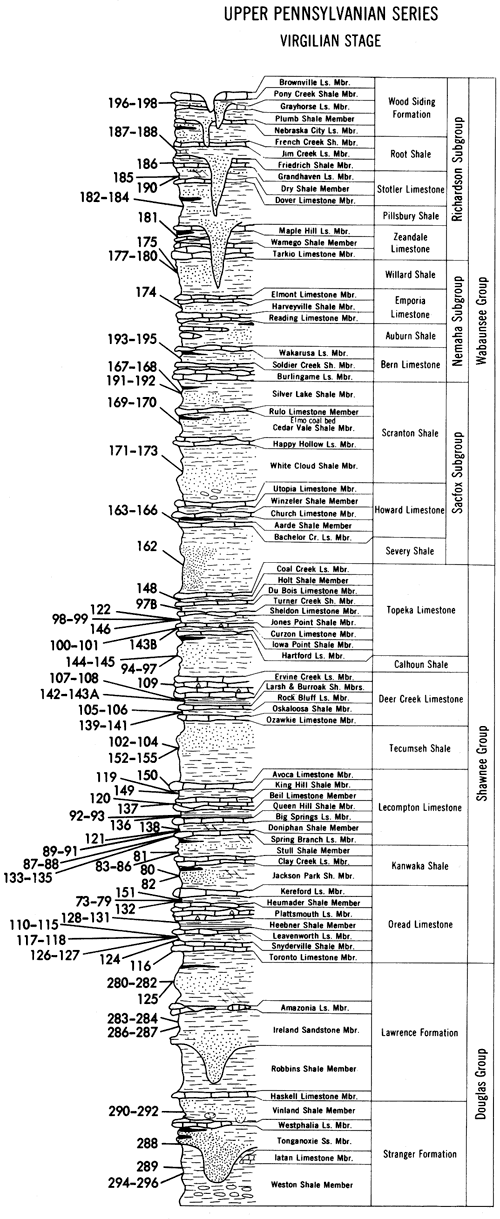
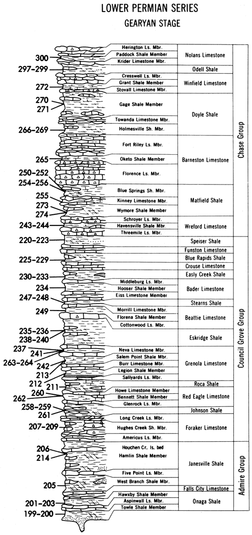
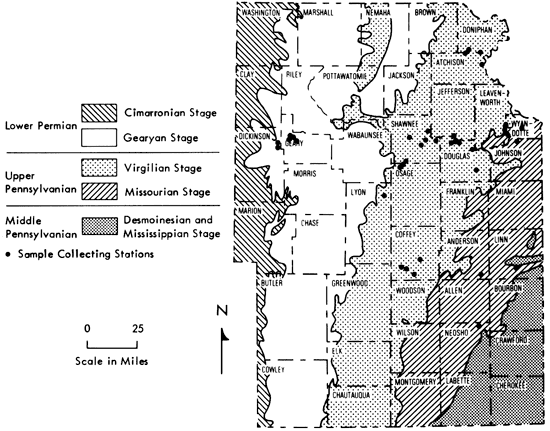
The Upper Pennsylvanian stratigraphic section (Figure 1) consists of two Stages--the Missourian and Virgilian. The Missourian Stage lies unconformably on the Desmoinesian Stage of the Middle Pennsylvanian, and is subdivided into the Pleasanton, Kansas City, and Lansing Groups. Conformably overlying the Lansing are the Douglas, Shawnee, and Wabaunsee Groups of the Virgilian Stage.
Figure 1--Stratigraphic distribution of samples.
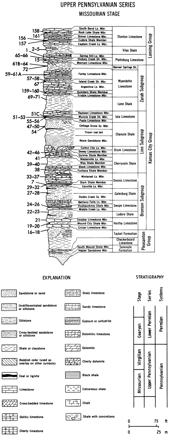
At the base of the Missourian Stage of the Upper Pennsylvanian is the Pleasanton Group, which is composed of 10-45 m of shale with some sandstone, limestone, and coal (Jewett et al., 1965). The irregular basal Hepler Sandstone Member rests in channels and is overlain by the South Mound Shale Member, the Checkerboard Limestone Formation, and the Tacket Formation. Shales are often rich in phosphate nodules (Runnels, 1949; Runnels et al., 1953; Rose and Hardy, 1967) and organic material (Jewett, 1940). Some lenticular sandstones are present in the Tacket Formation and are locally known as the Knobtown sandstone and Charlton conglomerate (Branson, 1962b; Jewett et al., 1965).
The Kansas City Group lying above the Pleasanton Group is characterized by six relatively thick, persistent limestone formations separated by six shale formations of variable thickness. Sandstones form a minor lithology in northern Kansas but thicken considerably towards Oklahoma (Schulte, 1959). Many of the limestones are algal, oolitic, and cross-bedded, locally thickening to form carbonate buildups (Hall, 1961; Merriam, 1963; Crowley, 1969; Hamblin, 1969; Heckel, 1972a, 1974, 1975a, 1975b, 1978). Thin discontinuous coal beds occur in the middle of the Kansas City Group and several "paper-thin" black shales act as marker horizons. This Group contains a number of limestones that wedge out in southern Kansas, e.g., in southern Allen County the Wyandotte Limestone pinches out, bringing the Bonner Springs Shale in contact with the Lane Shale to form a single inseparable unit termed the Lane-Bonner Springs Shale (Merriam, 1963). The Lane Shale has therefore been interpreted as a deltaic platform upon which the Wyandotte Limestone algal banks of eastern Kansas were formed (Crowley, 1969). Another deltaic clastic complex, the Bonner Springs Shale, then covered this buildup. Similar algal reefs have been reported in the underlying Iola (Heckel and Cocke, 1969), Dennis (Frost, 1968, 1975), Swope (Mossler, 1970, 1971, 1973; Scott, 1970), Cherryvale (Heckel and Cocke, 1969), and Hertha (Heckel and Cocke, 1969) Formations. Information on the intervening beds, with the exception of the Chanute Shale (Hall, 1961; Schulte, 1959), is minimal.
Conformably overlying the Kansas City Group is the Lansing Group consisting of two thick limestone formations separated by one shale formation. At the base, the Plattsburg Limestone consists of 7-28 m of limestone and shale, thickening towards the Oklahoma border. Algal buildups in the Plattsburg Limestone of southern Kansas have attracted much attention as possible oil traps (Davis, 1959; Harbaugh, 1959, 1960, 1964; Harbaugh et al., 1965). The Vilas Shale Formation (Kinell, 1962) varies in thickness and lithology southwards, directly attributable to the surrounding marine banks (Harbaugh, 1959). It is generally a monotonous, unferruginous marine shale but locally beds of sandstone and fossiliferous sandy limestones are found (Zeller, 1968). The Lansing culminates with the Stanton Limestone Formation consisting of three limestone and two shale members (Russell, 1974). The Formation's most distinctive features are the algal buildups in the limestone members (Wilson, 1957a, 1957b, 1962; Heckel, 1972a, 1972b, 1974, 1975a, 1975b, 1978) and the Eudora black Shale Member comprising approximately one meter of greyish-black fissile shale with phosphate nodules overlain by 1-2 m of calcareous green-grey and dark grey shale and is recognized both in subsurface and outcrop (Murphy et al., 1972; Heckel, 1975a, 1975b, 1978; Long, 1977). Trace fossils in the Rock Lake Shale indicate that the environment of deposition was represented by low wave energy euryhaline conditions (Hakes, 1975) and that the Rock Lake Shale marks a regressive phase before the transgressive South Bend Limestone.
The Douglas Group (O'Connor, 1963) consists largely of coarse shales and siltstones with occasional inpersistent thin limestones and local sandstone channels. A few thin coals make suitable marker horizons (e.g., Sibley coal beds). Beds in the group thicken from 80 m (260 ft.) in northern Kansas to 130 m (420 ft.) on the Kansas/Oklahoma border, but precise identification of horizons is problematic as distinguishing gross lithological characteristics are generally lacking and the lower boundary with the Lansing Group is often obscure (Ball, 1964). However, deltaic sandstone channels have been mapped in this Group by Winchell (1957), Sanders (1959), and Bower (1961). The Lawrence Shale Formation (Upper Douglas Group) was thought by Moore (1936, 1950) to represent a transgressive phase of sediment deposition. Faunal evidence now indicates that a restricted, marine environment existed and that no change from marine to non-marine can be inferred (Hakes, 1973). The Douglas Group is therefore considered to be a nonmarine phase separating the generally marine phases of the Lansing and Shawnee Groups.
The Shawnee Group consists of four limestone formations--Topeka, Deer Creek, Lecompton, and Oread Limestones--separated by thick shales and siltstones. Coals and sandstones are thin and of local occurrence only; e.g., the Elgin Sandstone (Brown, 1966, 1967) is a deltaic distributary complex that only outcrops in south-central Kansas. The thick limestone formations have been extensively described by Brown (1956), Perkins et al. (1962), Toomey (1964), Troell (1965, 1969), Galle and Waugh (1966), and Griesemer (1972) in terms of marine depositional environments, but the intervening Kanwaka, Tecumseh, and Calhoun Shale Formations are almost unknown (Hakes, 1975). Thin shales found in the limestone formations (Murphy et al., 1972; Rowell, 1973; Von Bitter, 1972, 1973; Brondos, 1974; Long, 1977) are also poorly described with the exception of the Heebner Shale (Evans, 1967, 1968; Calder and Attaway, 1971.), a paper-thin black shale lying between the Leavenworth and Plattsmouth Limestone Members. This is a very distinctive horizon and is consistently recognized both in outcrop and boreholes (Merriam, 1963). Shales of this type are recurrent features of the Kansas City, Shawnee, and Wabaunsee Groups and find extensive use as marker horizons (Moore, 1936, 1949, 1950, 1957).
The Wabaunsee Group conformably overlies the Shawnee Group and consists predominantly of shales and limestones with local sandstone lenses and several thin but persistent coal beds--the Nodaway and Elmo coals. The limestones are normally indistinguishable but the Dover, Zeandale, and Howard Limestones can be recognized by their lithology (Merriam, 1963). Channel sandstones occur in the Richardson Subgroup and often confuse the normal shale-limestone sequence (Mudge, 1956). A number of important underclays occur in association with the coals, e.g., Nodaway underclay (McMillan, 1956). The total group thickness is 165 m (540 ft.).
The Permian-Pennsylvanian boundary has been placed at the base of the Indian Cave sandstone of the Towle Shale Member (Zeller, 1968). This is unfortunately a poor choice of boundary as it is a channel sandstone of local importance only and is often difficult to recognize in the field. The Wellington Formation (Cimarronian Stage of the Lower Permian) has been suggested as an alternative by Branson (1960a, 1960b), and there has been recent palynological evidence for a Pennsylvanian-Permian boundary above the Eskridge Shale (Wilson, 1973). However, there is general agreement that little is to be gained by moving a boundary that has only reached reasonable stability in the past three decades.
The Lower Permian
The Lower Permian rocks of Kansas have been subdivided into two Stages, Gearyan (below), and Cimarronian (above). The Admire Group forms the lowest division of the Permian and consists of shale deposits with some thin limestones and coal beds. The sequence is similar to that of the underlying Wabaunsee Group and is difficult to differentiate on lithology alone. Conformably overlying the Admire Group is the Council Grove Group comprising approximately 100 m (325 ft.) of limestones and shales in 14 formations. The limestones are generally thinner and less massive than those in the overlying Chase Group, but they form a greater proportion of the total thickness than in the underlying groups. Another indication of changing sedimentary conditions is provided by the sudden increase in red and varicolored shales (Merriam, 1963). Together with cherty limestones, these characteristic sediments are interpreted by Moore and Merriam (1959) in terms of oscillating transgressions and regressions. This repetition is well developed in the Beattie Limestone (Walker, 1951; Imbrie, 1955; Imbrie et al., 1959, 1964; Laporte, 1962; Elias, 1964; Laporte and Imbrie, 1964). The paleoecology of the Red Eagle Limestone has been interpreted in similar terms (McCrone, 1963) and the Eskridge Shale has been examined in connection with the Pennsylvanian-Permian boundary problem (Brookings and Chaudhuri, 1973) and depositional environments (Wells, 1950; Moore, 1957, 1959; Mudge and Yochelson, 1962; Cullers, 1974; Russell, 1974; Cullers et al., 1975). Red shales, green shales, cherty and dolomitic limestones characterize and divide the Chase Group into seven alternating shale and limestone formations. There is a noticeable increase in the number of evaporite horizons, suggesting some restriction of the Kansas sea at this time. Little information is available, however, on horizons in the Chase Group (Murphy et al., 1972), except those in the Wreford Limestone Formation, which have been examined paleontologically by Cuffey (1967), Newton (1970, 1971), Warner and Cuffey (1973), Bifano et al. (1974), and Lutz-Garihan (1974), sedimentologically by Hattin (1957) and Lutz-Garihan and Cuffey (1973), and geochemically by Cullers (1974) and Cullers et al. (1975).
Cyclicity of the Sediments
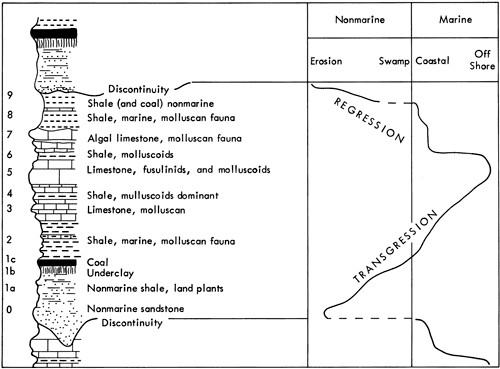
R. C. Moore (1936, 1949, 1950, 1959, 1964) recognized repetitive associations of sediments in the Pennsylvanian and Permian stratigraphy of Kansas which he termed cyclothems and interpreted as recurrent transgression/regression sequences. The typical or "ideal" cyclothem (Figure 2) consists of 10 beds symmetrically developing from a non-marine sandstone or shale (0, 1a) up to a fusulinid limestone (5), representing the culmination of normal marine transgression, and then back to a non-marine shale and sandstone bed (9), representing the regressive marine phase. This "ideal" cycle is characteristic of Wabaunsee Group sediments (Moore, 1949).
Figure 2--Diagrammatic section of Pennsylvanian rocks in Kansas showing the "ideal cyclothem" (after Moore and Merriam, 1959).
However, this is not a common occurrence in Kansas and a number of different cyclic sequences have now been recognized (Heckel, 1975a, 1975b, 1977; Heckel and Baesemann, 1975). In the Shawnee Group, for example, the most distinct cycle consists of a black shale followed by thick limestones separated occasionally by thin calcareous shales. Frequently, a thick, coarse, non-marine shale occurs between each group of thick limestones. The Lansing and Kansas City beds also contain cyclothems that bear no resemblance to the "ideal" cyclothem, and Abernathy (1937) noted little correlation between Cherokee cyclothems (Desmoinesian Stage) and the "ideal" cycle. However, recently Shannon (1978) recognized similarities in Cherokee cycles and clay mineral repetitions indicative of cyclic changes in depositional environments. In the Permian beds, cycles were recognized by Moore and Merriam (1959) and Elias (1937, 1964). The variation in Kansas cyclothems is summarized in Table 1 and it is clear that the "ideal" cyclothem is certainly not the typical cycle developed in Kansas. Merriam (1963) has pointed out that this variation is a result of the non-development of particular beds or their development and subsequent destruction. However, Branson (1962b) describes the situation more forcefully: "A general misconception of the nature of cyclical sediments has been widely held. An ideal cyclothem has not been found and in the Mid-Continent, no cyclothem approaches the ideal."
Table 1--Variation in Kansas cyclothems.
| Pennsylvanian | Lower Permian | ||||
|---|---|---|---|---|---|
| Desmoinesian | Missourian | Virgilian | |||
| Cherokee | Marmaton | Kansas City and Lansing |
Shawnee | Wabaunsee | |
| Shale, calcareous | |||||
| Limestone | |||||
| Shale, grey | Shale, grey to brown, or Limestone |
Limestone | Limestone | Limestone | |
| Shale, black | Shale, black, platey | Shale or Limestone with marine fossils |
Shale, marine, black |
Shale, marine | Shale, marine |
| Coal | Coal | Coal | Coal | Coal | |
| Underclay | Underclay | Underclay | Underclay | Underclay | (Evaporites) |
| Shale (sandy) | Shale (sandy, silty, and clayey) |
Shale (sandy to clayey) |
Shale, non-marine |
Shale, non-marine |
Shale, non-marine, red |
| Sandstone | Sandstone, non-marine |
Sandstone, non-marine |
Sandstone, non-marine |
Sandstone, fine, micaceous |
|
| Moore, 1949 | Moore, 1949 | Moore, 1949 | Moore, 1936 | Moore, 1950 | Moore & Merriam, 1959 |
In comparison, Moore (1959) considered that the different Upper Pennsylvanian and Lower Permian sedimentary cycles recognized were minor variations of the "ideal" sequence. Repetitive occurrences of these cyclothem varieties were also noted and termed "cycles of cyclothems" or megacyclothems (see also Heckel, 1977, 1978). The Shawnee succession consists of two distinct cyclic sequences, a simple shale sequence which corresponds to one Wabaunsee cyclothem and the more common complex limestone-shale sequence which, with some imagination, corresponds to one or three Wabaunsee cycles. As a result, the Shawnee succession could represent a sequence of complex and simple cycles or megacyclothems.
Although some units, particularly limestones, can be traced from Oklahoma to Pennsylvania (Moore, 1959) and cover areas as large as 80,000 sq. mi. (Duff et al., 1967), it is not easy to see how individual cyclothems and megacyclothems are delimited. Duff et al. have noted that units are not too infrequently assigned to different cyclothems in different studies, presumably indicating how incomplete the cyclothems are. This is further exemplified by the variation in the number and thickness of cyclothems recorded. Wanless (1950) recognized 25-30 cycles in Kansas, whereas Branson (1962b) identified 60 from the Oklahoma/Kansas border, 41 containing coals, and Merriam (1963) said that 85 cycles can be identified from the base of the Cherokee to the top of the Pennsylvanian system. In comparison, Kosanke et al. (1960) recognized only 37 from Illinois.
Schwarzacher (1969) analyzed the Kansas City and Shawnee cyclothems mathematically and developed a different classification of lithologies based on Merriam's (1963) original field descriptions. This cyclothem could be described as consisting of five limestone and one shale units in each cycle:
| Example | |
|---|---|
| LIMESTONE 5 | Clay Creek |
| OUTSIDE SHALE | |
| LIMESTONE 4 | Kereford |
| LIMESTONE 3 | Ervine Creek |
| LIMESTONE 2 | Leavenworth |
| LIMESTONE 1 | Toronto |
| OUTSIDE SHALE |
"Limestone 1" to "Limestone 4" are separated by inside shales, of which the black shale following "Limestone 2" is the most characteristic. The reduction of the clastic beds from the "ideal" six or seven units to an outside/inside shale subdivision still preserves the cyclic nature of the sequence, and quantitative analysis revealed a 13-20 m (42-65 ft.) oscillation. This compares with a manual determination of 24.5 m (80 ft.) for the average cyclothem (Schwarzacher, 1969), the difference being attributed to the classification of the Douglas Group as an outside shale. Schwarzacher admits that this classification may be a mistake geologically but states there is no evidence for a missing cycle and it is obvious that the Douglas Group represents abnormal sedimentary conditions. Such irregularities are eliminated to an extent using the method of recurrent probabilities and it is for this reason that the reconstructed cyclothem is a valuable aid to interpreting the nature of the succession.
Nevertheless, Moore's cyclothem phases would be ideal lithological states if one were able to recognize the phases by their lithology and faunal characteristics. However, available descriptions do not allow such an identification, nor to the author's knowledge has such an attempt been successful. A less detailed classification is possible. By combining lithologies described as "yellowish shale, shales with plant fragments, silts, sands and sandstones" into one group and "grey fossiliferous shales, shales with predominantly molluscan fauna" and "black fissile shales" into a second group, two states can be obtained which closely resemble outside and inside shales. Thus a three-state system could be adopted consisting of limestone, outside shale, and inside shale (see Heckel, 1978).
Pearn (1964) distinguished only five lithologies in Pennsylvanian sediments which constituted a revised form of Moore's "ideal" cycle.
5. Limestone with fusulinids and molluscoids
4. Shale, molluscoids dominant
3. Limestone with molluscans
2. Shale, non-marine with coals, shale with molluscan fauna
1. Sandstone
Certain problems were recognized in classification by these five lithologies, yet it was noted that the average cyclothem observed in Kansas would be similar to that proposed by Moore (1959).
Davis and Cocke (1972), on the other hand, recognized 17 lithologies including nine clastic units in a study of Kansas City and Lansing Group cycles. Using a technique known as substitutability analysis, a classification procedure that groups states on the basis of their context in a sequence, it was concluded that lithologies must be grouped into fewer than eight states before any cyclic pattern emerges from the Upper Pennsylvanian succession. Further analysis revealed that the stratigraphical succession contains a pattern of alternating calcilutites, calcarenites, and marine shales. Sporadic incursions of coarser sediment may interrupt this pattern at any point. It may, therefore, be inferred that the various limestones and inside shale facies are interrelated and the occurrence of a specific lithological type at certain points within the sequence seems to have no great significance. In contrast, the coarser outside shales and siltstones seem to represent a clastic influx independent of the basic depositional pattern. Thus, Davis and Cocke infer that the limestone-inside shale depositional environment constitutes the normal sedimentation pattern with an occasional influx of coarser outside shales.
In recent studies of the Stanton Formation and the Shawnee Group in eastern Kansas, Heckel (1975a, 1975b, 1977, 1978) and Heckel and Baesemann (1975) have enlarged upon Moore's original concept of a typical cyclothem and have recognized a "basic cyclothem" consisting of an outside shale-limestone-core shale (black)-limestone-outside shale sequence that is based upon detailed facies and paleontological analysis. Within this framework, black shales are recognized to be genetically distinct from the other shales on facies, conodont (Baesemann, 1973; Heckel and Baesemann, 1975), and geochemical evidence (Cubitt, 1975b) and are thought to have been formed during high sea-level periods when "a thermocline allowed prevailing trade winds to establish quasi-estuarine circulation cells resulting in depletion of bottom waters and concentration of phosphate" (Heckel, 1977, 1978). This contrasts with earlier visions of black shale formation that predominantly centered on a barred basin concept (Heckel, 1972a, 1972b). However, recent evidence from other Precambrian, Paleozoic, and Mesozoic epeiric and shelf seas suggest that tidal currents or progressive ventilation of the oceans may provide the mechanism for stagnation of bottom waters and development of black shale facies (Berry and Wilde, 1978; Klein and Ryer, 1978). The environment of deposition of these deposits remains problematic (see, for example, the alternative suggestions put forward by Heckel (1977, 1978) and Berendsen and Zeller (1978) for the depth of formation of black shales).
Moore's "ideal" cyclothem has, therefore, been questioned by detailed analysis of reported cyclic sequences. Yet there are many notable geologists who accept cyclic sedimentation without doubt. Zhemchuzhnikow (1958) wrote: "Those who accept rhythm in nature will find it when it is rather indistinct, and they will arrive at proper conclusions. Those who do not want to, will not find it even when it is obvious."
Tectonic History of Midcontinent During the Upper Pennsylvanian and Lower Permian
Throughout the Pennsylvanian and Permian, Kansas was covered by a shallow epeiric sea (Heckel, 1972a, 1972b) and sediment was continually deposited in a number of broad, north-south trending anticlinal and synclinal structures (Figure 2). Local and external tectonic events affected the sedimentary succession throughout Kansas, and Weller (1956) went as far as to propose that cyclic patterns in Kansas sediments are a product of tectonism alone.
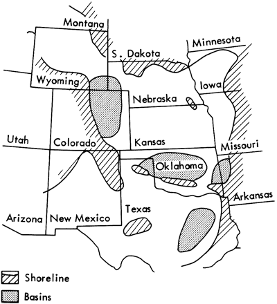
Structurally, Kansas is split into five regions (Merriam, 1963) that were active during the Pennsylvanian and Permian eras. The Forest City Basin (Anderson and Wells, 1968), occupying the northeast and eastern edge of the state, is a remnant of the earlier North Kansas Basin and has been a depositional area since the Arbuckle period (Lower Ordovician). It contains approximately 1300 m (4000 ft.) of Paleozoic sediments lying on Precambrian metamorphics with the greatest thickness of sediment recorded on the basin's western flank. The basinal axis, the Brownville Syncline (Condra, 1927) trends slightly east of north and lies close to the axis of the Nemaha Anticline, producing an asymmetrical basin profile.
The Nemaha structural zone was active during the Mississippian (Branson, 1962b; Merriam, 1963) and was block faulted down the east side (Berendsen, personal communication). Some sediments were eroded from the northern end and deposited along the eastern flank. The anticline separates the Forest City Basin from the Salina Basin (Reed, 1954), a post-Mississippian syncline trending northwestwards and plunging northwards with the greatest thickness of sediment recorded in north-central Kansas. To the southwest of the Salina Basin lies an indistinct unnamed saddle (Merriam, 1963), delimiting the edge of the Sedgwick Basin. This shelf-like, northerly plunging area in southern Kansas is a major pre-Desmoinesian, post-Mississippian structural feature. Southwards, sedimentary facies change and thicknesses increase as the Sedgwick Basin passes into the Anadarko geosynclinal Basin.
The extent of the Mississippian beds in Kansas outlines the northern-trending pre-Desmoinesian, post-Mississippian Central Kansas Uplift, and in the southwest lies a large shelf-like extension of the Oklahoma Anadarko Basin, the Hugoton Embayment (Maher and Collins, 1948). These areas separate the tectonically active Denver and Anadarko Basins, with sediments thickening considerably off the shelf (Denison, 1976; Rascoe, 1976). The Hugoton Embayment development was completed by the Mesozoic with a peak during the Desmoinesian.
Tectonic activity in these regions made a distinct impression on the sedimentary succession of Kansas but these effects were of minor significance in comparison to the tectonic activity in Kansas' neighboring states: in Oklahoma and Arkansas the Ouachita orogeny was reaching its peak in the Pennsylvanian and Permian; in Colorado, Idaho, and New Mexico the ancestral Rocky Mountains were developing rapidly; and in Missouri the Ozark Dome was shedding sediments into the epeiric sea covering Kansas.
Surrounding Kansas therefore during the Pennsylvanian and Permian was a series of mountain ranges stretching from the Ozarks of Missouri to the Black Hills of South Dakota (Figure 3). These were the major sources of sediment for the Kansas Basins, and tectonic events within the mountain regions produced dramatic changes in sediment deposition in the shelf seas of Kansas and Colorado (Figure 4).
Figure 3--Tectonic features of the Midcontinent during the Upper Pennsylvanian and Lower Permian (information obtained from Flawn et al., 1961; Branson, 1962b; Rascoe, 1962; Wilson, 1962; Merriam, 1963; McKee and Oriel, 1967; Clark and Stearn, 1968; Troell, 1969; Dott and Batten, 1971; Fagerstrom and Burchett, 1972; Heckel, 1972a, 1972b; Hills, 1972; Galloway and Brown, 1973; Lumsden et al., 1973; Ross, 1973; Jacka, 1974; and Werner, 1974).
- Arbuckle Mts.
- Wichita Mts.
- Amarillo uplift
- Apishapa uplift
- Uncompahgre uplift
- Bighorn Mts.
- Forest City basin
- Nemaha Anticline
- Salina Basin
- 1Central Kansas uplift
- Hugoton embayment
- Dalhart basin
- Sedgwick basin
- Anadarko basin
- Plainview basin
- Fort Worth basin
- Llano uplift
- Midland basin
- Scurry platform
- Central basin platform
- Delaware basin
- Diablo platform
- Northwestern shelf
- Central Colorado trough
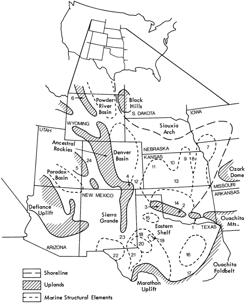
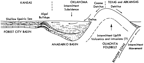
Figure 4--A schematic section illustrating detrital sediment buildup in Kansas with the orogenic development of the Ouachita foldbelt.
Considering first the Ozark Dome of east-central Missouri, we find that the area remained a complex uplifted block of Precambrian and Cambrian igneous and sedimentary rocks from the early Paleozoic. Although channel sandstones are revealed in many Pennsylvanian deposits including Wabaunsee and Lower Permian sediments (Hinds and Greene, 1915; Mudge, 1956; Mudge and Yochelson, 1962), the Dome is considered to have been stable during this period (Elias, 1964) and sediments deposited in the Forest City Basin were predominantly silts and clays (Anderson and Wells, 1968).
To the south of the Ozark Dome lie the Ouachita Mountains (King, 1961; Morris, 1973; Gordon and Stone, 1973; Haley and Charles, 1973; Viele, 1973), an Arkansas range that developed during orogenic movements in the Mississippian, Pennsylvanian, and Permian Eras (Keller and Cebull, 1973). Structurally associated with the Ouachitas are the Arbuckle and Wichita Mountains of Oklahoma and the Amarillo Uplift of Texas. This chain of mountains forms one arm of the Ouachita-Appalachian tectonic region (Thomas, 1973) that has been interpreted in terms of the Dewey and Bird (1970) model for a thermally driven cordilleran-type mountain belt by Keller and Cebull (1973), Rowett and Walper (1973), Walper and Rowett (1973), Cebull and Keller (1974), Cebull et al. (1974), Griffin (1974), Rowett (1974), Cebull et al. (1976), Thomas (1976), and Wickham et al. (1976). It is generally accepted that the Ouachita orogenic belt developed as the failed arm of a three-armed radial rift system (Hoffman et al., 1974; Stewart, 1976) and represents a continent/arc collision (Walper and Rowett, 1973; Hatcher, 1973, 1974) marking an early event in the opening of a proto-Atlantic Ocean. Walper and Rowett also propose that the Ouachita orogenic belt is continued in the foldbelts of Mexico and Central America and that apparent offsets in the tectonic belt are manifestations of ancient transform faults (Cebull et al., 1976).
In Colorado, northern New Mexico, and southern Idaho, a chain of mountains commonly known as the Ancestral Rocky Mountains developed in response to orogenic movements during the Late Devonian to early Mississippian or early Pennsylvanian interval. Sediments were shed into deep basins on either side of this chain during the Pennsylvanian and Permian Eras developing approximately 5000 m (16,250 ft.) of coarse clastics in the Denver Basin (Chronic, 1964). No easterly sediment transport directions have been recorded in west Kansas as the effects of the orogenic movements were limited to Colorado and little sediment reached Kansas.
The Ancestral Rockies are continued in Idaho by the Bighorn Mountains, a long sinuous mountain chain marking the western boundary of the Powder River Basin. Undulating deltaic lowlands persist from North Dakota to the Ozark Dome and form the boundary for the Powder River Basin, Denver Basin, and Kansas shelf sea. The lowlands were not tectonically active during the Pennsylvanian and Permian and supplied limited quantities of sediments to the basins (McKee and Crosby, 1975).
It would appear that the Kansas shelf sea was surrounded by lowlands and orogenic mountain belts. However, one narrow channel to the open marine seas in northwest Texas existed. The Dalhart Basin, separating the Amarillo Uplift and the Apishapa Uplift (part of the Ancestral Rockies), may have formed a shallow barrier bar during the Pennsylvanian and Permian and produced, in extreme conditions, a stratification of the seas in the Kansas area, anaerobic bottom waters, and the development of a black shale lithology (cf. Black Sea. sediments, Heckel, 1972a, 1972b).
To illustrate the tectonic development of the Midcontinent during the Pennsylvanian and Permian, three generalized paleogeographic maps are presented (Figures 5, 6, 7). Initially, in the early Paleozoic, a Benioff zone was instigated in the Gulf Coast region of Texas and slow movement of the oceanic plate down the Benioff zone resulted in the development of an orogenic zone in Arkansas, Texas, and Oklahoma. A shallow shelf sea extended northwards from the orogenic belt onto the stable cratonic continental crust of Kansas, with a deep subsiding basin, the Anadarko Basin, separating them. During the early Pennsylvanian, development of the orogenic belt reached its peak, as an "orogenic welt" arose and great thicknesses of flysch were deposited on the collapsing shelf (McBride, 1969). Some of these "clastic wedges" (Ferm, 1973) spread over the shelf, thinning rapidly northwards, and in the Forest City Basin, the thicker, coarser shales may represent the finer fraction of the "clastic wedge" lithologies. The flysch deposits were followed in the late Pennsylvanian/early Permian periods by a mollasse facies marking the cessation of subduction and orogenic activity. Subsequently, stabilization of the orogenic belt resulted in the disappearance of "clastic wedges" from Kansas and the development of evaporite/carbonate sedimentary sequences.
Figure 5--Upper Pennsylvanian (Missourian Stage) paleogeography of the Midcontinent (adapted from Sloss et al., 1960; Rascoe, 1962; Wanless et al., 1970; and Moore and Nelson, 1974).
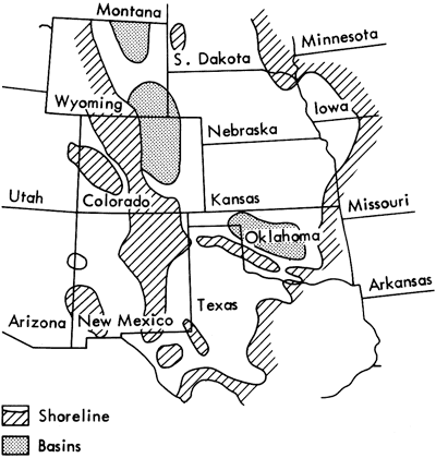
Figure 6--Upper Pennsylvanian (Virgilian Stage) paleogeography of the Midcontinent (adapted from Sloss et al., 1960; Rascoe, 1962; Schubert, 1963; Clark and Steam, 1968; Troell, 1969; Dott and Batten, 1971; Heckel, 1972b; and Moore and Nelson, 1974).
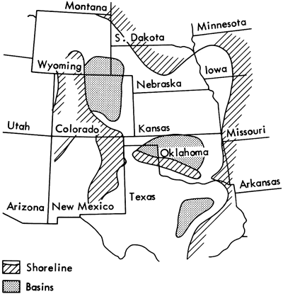
Figure 7--Lower Permian (Gearyan Stage) paleogeography of the Midcontinent (adapted from Sloss et al., 1960; Rascoe, 1962; Schubert, 1963; Elias, 1964; McKee and Oriel, 1967; Hills, 1972; Ross, 1973; Seyfert and Sirkin, 1973; and Moore and Nelson, 1974).
Bott and Dean (1973) studied stress diffusion at plate boundaries and noted that movement along subduction zones was of cyclic nature, i.e., movement along the zones was possible only when frictional resistance was overcome by continually increasing pressure originating from the mid-ocean ridges. It is to be suspected that similar conditions existed in the Pennsylvanian and we can infer that the Ouachita Mountains development was cyclic and that the occurrence of thick, coarse "clastic wedge" deposits in Kansas is a reflection of this cyclic mountain building. This may account for the regular repetition of coarse clastics in the sedimentary succession. The excessively thick Douglas clastics may also be explained in terms of sudden large-scale orogenic movement (possibly, the culmination of the Pennsylvanian orogeny) in the Ouachita belt.
Thus, in Kansas during the early Pennsylvanian, it is speculated that the rise of the Ouachita system deposited thick clastics in the Anadarko Basin and, during sudden uplifts in the mountain chain as a result of cyclic subduction, clastic wedges spread out onto the shelf sea of Kansas. This situation predominated until orogenic movement ceased at the end of the Permian era.
The normal sedimentary deposits formed in the Kansas epeiric sea during the Pennsylvanian consisted of limestones alternating with thin, calcareous shales (Heckel, 1972a). Algal buildups of southern Kansas developed in response to subsidence in the Anadarko Basin. In comparison, the intervening clastics were deposited from deltas on the lowlands to the east and north of Kansas.
The orogenic belt of Colorado, New Mexico, and Idaho throughout this period was providing coarse clastic sediments for the Denver and Powder River Basins but had little direct effect on the sedimentary succession of Kansas. It did, however, complete a ring of land around Kansas, providing a classic epeiric sea setting for the Kansas shelf. The narrow Dalhart Basin separated the Ouachita and Rocky Mountains and may have formed a barred entrance to the Kansas sea. As a result, stratification of the epeiric sea may have occurred at a number of times during the Pennsylvanian (Heckel, 1972a), encouraging anaerobic conditions to prevail in the bottom waters and sediments of the sea. Black shales, a distinct lithology used as a marker horizon in the "ideal" cyclic sequences (Moore, 1950), may be developed in these anaerobic conditions and are normally enriched in trace elements. Alternatively, the narrow basinal entrance may have provided suitable conditions for the development of quasi-estuarine circulation cells (Heckel, 1978).
With the cessation of orogenic development in the Ouachitas at the beginning of the Permian (Figure 7), the paleogeographic conditions of the Midcontinent changed dramatically. Carbonate deposition increased and, towards the end of the Council Grove Group, evaporite sediments developed substantial thicknesses. The Amarillo Uplift-Wichita Mountains-Arbuckle Mountains belt became a series of islands (Rascoe, 1962) separating the Ouachita and Rocky Mountains, and the Kansas epeiric sea became a partially barred carbonate/evaporite basin similar to that of the Mediterranean during the Miocene (Hsu et al., 1973). The tear-drop distribution of carbonate and evaporite sediments (McKee and Oriel, 1967, Figure 4) reflects the partially barred nature of the Kansas Permian sea.
To summarize, therefore, tectonic events in Oklahoma, Texas, and Arkansas have affected the Pennsylvanian and Permian sedimentary succession in Kansas and suggest a fourfold division of the clastic sediments. First, there are the carbonate-rich shales characteristic of "normal" carbonate/shale deposition in the Kansas epeiric sea. The second division is a variation of this theme--the distinctive black shale lithology characteristic of anaerobic bottom waters or upwelling phosphate-rich waters. Next, from the east came a number of deltaic channel sandstones, siltstones, and shales that were deposited in the Forest City Basin. Finally, thick, coarse clastic units are found at regular intervals up the Pennsylvanian stratigraphic section that are derived from the Ouachita tectonic belt of Oklahoma, Arkansas, and Texas.
Sampling Pattern
Stratigraphically, each clastic horizon in the Upper Pennsylvanian and Lower Permian is not necessarily restricted to a unique lithology. In fact, in Moore's classification, two or even three lithological divisions of a cyclothem could be found in one clastic bed. As Moore based his conclusions on field and hand specimen evidence, it was concluded that lithologies, recognizably different in the field, should be sampled for mineralogical, petrological, and geochemical analysis. Samples were collected from horizons in the Tacket Formation (Pleasanton Group) and all clastic units up to the Paddock Shale Member of the Nolans Limestone (Chase Group); the distribution can be seen in Figure 1. The only exceptions were the Auburn and Winzeler Shales (Wabaunsee Group) where lack of surface exposure prevented adequate collection.
Samples collected for each horizon are considered representative of a single shale facies for many miles along the outcrop strike. Merriam (1963), for example, has commented on how it is possible to recognize single lithologies over remarkable distances in Kansas and bow stable bed thicknesses are.
The distribution of sample collecting stations in eastern Kansas (Figure 8) was restricted to the Forest City Basin. A comparison of the sample distribution and Heckel's concept of facies belts within the Pennsylvanian (Heckel, 1978) indicates that the majority of samples were collected in the "open marine facies." However, adequate exposures in some cases could only be found in southern Kansas. In the latter situation, it should be noted that clastic deposits do coarsen and thicken southwards from south Kansas into the Anadarko Basin of Oklahoma implying that the south Kansas outcrops will not necessarily be representative of the normal Pennsylvanian and Permian sediments in the Forest City Basin. Interpretation of analytical results in succeeding sections will take this into consideration.
Figure 8--Distribution of sample-collecting stations in eastern Kansas.
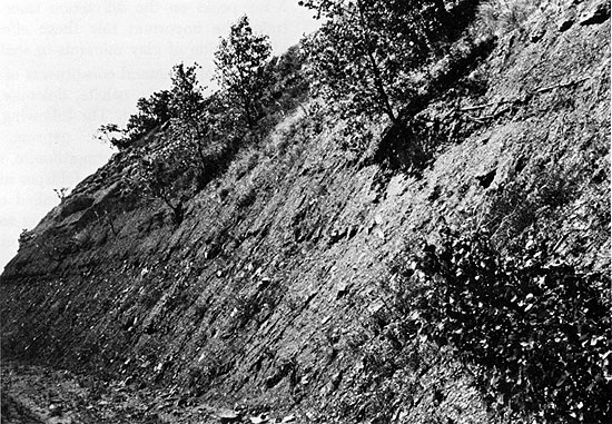
Outcrops of Pennsylvanian and Permian deposits are found along highways cutting east-west across the state (Plate 1). Samples collected from such exposures were extracted at a depth of six inches from the surface to obtain relatively unweathered sediments. Suitable samples were then thin-sectioned and analyzed by X-ray diffraction, emission spectroscopy, and electron spin resonance. Appendix 3 summarizes the sampling information in tabular form, recording sample number code, collecting station, and analyses performed on each sample.
Plate 1A--Important outcrops of Shawnee Group beds on Interstate 70, west of Lawrence, Kansas.
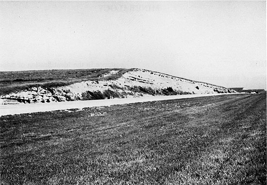
Plate 1B--Road cutting exposure of Vilas Shale near Altoona, Wilson County in southern Kansas.
Analyses were performed on a representative selection of sediments extracted from the total sample collection. This was considered necessary to establish overall trends and cycles throughout the stratigraphical section and avoid unnecessary noise caused by minor lithological variations. Therefore, only gross lithologies were analyzed for mineralogical and geochemical variations.
Prev Page--Contents || Next Page--Mineralogy
Kansas Geological Survey, Geology
Placed on web May 6, 2009; originally published December 1979.
Comments to webadmin@kgs.ku.edu
The URL for this page is http://www.kgs.ku.edu/Publications/Bulletins/217/02_intro.html