![]()
Prev Page--Contents || Next Page--History of Nomenclature
Introduction
Purpose and Scope of the Investigation
Description of the Greenhorn Limestone in Kansas is included in a large number of State Geological Survey bulletins that treat collectively the geology of most counties lying along the outcrop. In these reports the detail with which the formation is described ranges widely in quality and completeness. Except for studies in Russell County (Rubey and Bass, 1925) and of Greenhorn ammonites by Morrow (1935) and by Cobban and Scott (1972) little has been published on the stratigraphic distribution of the macroinvertebrate fossils, and almost nothing has been published concerning geographic distribution of the fossils. The writer (Hattin, 1971) has discussed the regional stratigraphy and origin of burrow-mottled limestone beds in the middle part of the formation but no other attempt has been made previously to synthesize stratigraphic, lithologic, and paleontologic data gathered from all areas of the Kansas outcrop.
This study is based on field investigations conducted during parts of each summer from 1962 to 1968, and 1971, and on laboratory study of rock samples and fossils collected during that period. Locality data for all studied sections are summarized in Table 1. Detailed measurement of the Greenhorn section at key locations across the State has been used to document the remarkable lateral persistence of many limestone beds in the formation and to demonstrate the uniformity of vertical sequence in most areas. These features are depicted graphically in Plate 1. Special attention has been accorded the systematic search for macroinvertebrate fossils for the following reasons: 1) this part of the fauna is incompletely known, 2) the formation has not been zoned adequately throughout the State, and 3) because of the need to effect more accurate correlation with other parts of the Western Interior region, with the Gulf Coast region, and with other parts of the world. Lithologic composition, texture, and structure; stratigraphic distribution of rock types; and distribution, diversity, and abundance of fossils all have been used to shed light on the probable conditions of origin of Greenhorn rocks in the State. A primary objective of this investigation has been the interpretation of depositional environments, paleoecology, and the evolution of the Kansas section as a part of the Upper Cenomanian and Lower Turonian stratigraphic framework of the Western Interior region.
Although a great body of data has been gleaned from X-ray analyses, thin section point counting, study of laminations, and insoluble residue determinations, as well as from field study of measured sections, a report including all these aspects of the rocks would be needlessly cumbersome. Therefore, some parts of the study have been treated as separate entities and are published elsewhere (Hattin, 1968, 1969, 1971; Hattin and Darko, 1971; Hattin and King, in preparation; Kauffman and Hattin, in preparation). The results of these separate studies are merely summarized and the conclusions therein incorporated in the general synthesis. It is hoped that this report will stimulate further investigation of Greenhorn rocks in Kansas; of especial interest in this regard are quantitative studies of trace-fossil distribution and diversity, geochemical studies directed toward further evaluation of depositional conditions for chalk deposits, and ultramicroscopic analysis of fine-grained carbonate rocks.
Previous Work
[Note: Paleontologic studies of vertebrate fossils are omitted.]
Among the earliest accounts of beds referable to the Greenhorn Limestone are those by Hayden (1872, p. 67), Mudge (1876, p. 219; 1877, p. 289; 1878, p. 64) and St. John (1883, p. 589; 1887, p. 145). In all of these reports the stratigraphic descriptions are brief; in the first three and in the last of the six papers cited the Greenhorn beds were assigned erroneously to the Niobrara Chalk. Mudge (1876, 1877) recorded the fossils Inoceramus problematicus (I. labiatus), Gryphaea, Belemnite (sic), and an Ammonite (sic) in a persistent, thin stratum which from description is apparently the Fencepost limestone bed. [Note: To my knowledge Gryphaea does not occur in the Greenhorn of Kansas. Prof. Mudge may have referred to small specimens of Inoceramus cuvieri which are common in the upper part of the Greenhorn and which, when not completely exposed, bear superficial resemblance to Gryphaea.] In a later paper St. John (1883, p. 589) reported the presence of Ostrea congesta in limestones of the Fort Benton Group but he included the Fort Hays Limestone Member (of the present nomenclature) in the Benton and did not make clear to which limestone he referred. In yet another description of the Benton in Kansas, Hay (1889, p. 101) reported the common occurrence of petrified logs in beds now assigned to the Greenhorn. Division of the Kansas Benton on a sound lithologic basis was attempted by Cragin (1896) but his work was ignored, presumably because formational names used by him were preoccupied. He was apparently first to use the name "fencepost bed" for the top layer of chalky limestone in the Greenhorn, and the name "Lincoln Marble" for beds now included in the Lincoln Member. In a more comprehensive division of the Benton, Logan (1897, p. 216) also used the name "Lincoln Marble" for basal beds of the Greenhorn; names used by him for other parts of the Greenhorn have since been dropped. The earliest major work involving Greenhorn fossils in Kansas is that of Logan (1898) who described fossils of the Benton, Niobrara, and Fort Pierre Groups. In a table he listed 23 species of invertebrates, ascribing 11 to the Lincoln Marble and the rest to the Limestone Group (remainder of Greenhorn of present usage). In the text, however, four of the species tabulated as Lincoln are described as coming from beds below the Lincoln and six more of these are not described at all. In addition, four species described in his text as occurring in the Lincoln or Fort Benton Limestone Group are not included in his table of species. Of the Greenhorn species I have recorded in the present report, only two (Collignoniceras woollgari and Mytiloides labiatus) are included in Logan's work. Some of the species that Logan attributed to the Greenhorn are now known to be restricted to younger beds, and a few of the forms he described are now recognized under totally different names. Many of the species he recognized in the Kansas section are illustrated by figures of non-Kansas specimens and were taken from older works. In terms of biostratigraphy and taxonomic paleontology much of his work is meaningless.
In a later work Logan (1899) gave a detailed description of the Limestone Group (Greenhorn of present nomenclature) of Kansas; though still retaining the Bituminous shale (Graneros Shale) in the Limestone group, he described the former unit separately, perhaps recognizing the need for classification as a discrete unit the shales now called Graneros. In this paper he gave the name Ostrea congesta var. bentonensis to the little oyster that is common in the upper part of the Greenhorn and lower part of the Fairport Member of the Carlile Shale. He (Logan, 1899, p. 91) terminated the paper with a table showing correlation of the Bituminous shale and the Limestone group of Kansas with the Graneros Shale and Greenhorn Limestone, respectively, of Colorado. In another work on the Cretaceous fossils from Kansas,, Logan (1899a, p. 214, 215) described Ostrea beloiti and Astrocoenia conica from the Lincoln. [Note: No subsequent record of this coral is known to me.]
The term "Greenhorn" was first used for Kansas rocks by Darton (1904, pl. 36); he (Darton, 1905, p. 152-154) summarized briefly the stratigraphy of the Kansas section, using the nomenclature of Logan (1897), but recognizing a unit called "shales" between the Lincoln marble and the Flag horizon.
An abbreviated account of the Kansas Greenhorn appeared in the work "Oil and Gas Resources of Kansas" by Moore and Haynes (1917, p. 129) and Moore (1920, p. 129) repeated this description verbatim. Darton (1920, p. 2) described the Greenhorn of the Hamilton and Kearny county area, but persisted in using the nomenclature of Logan (1897). For Kansas geology Darton's publication marked the end of an era that was characterized by generalized descriptions of the Greenhorn.
Beginning with the Russell County report of Rubey and Bass (1925) the State Geological Survey issued over a period of eight years a series of Bulletins [Note: Bull. 10, 1925; Bull. 11, 1926; Bull. 15, 1930; Bull. 16, 1930; Bull. 19, 1932.] describing the geology of nine counties that include parts of the Greenhorn outcrop. These reports contain the most comprehensive treatments of the Greenhorn that have been published heretofore and founded our present knowledge of thickness, lithology, important fossils, and correlations. The Greenhorn members, as now recognized by the Kansas Geological Survey, were named and defined in the first two of these bulletins. A tabulation of fossils by members is included in Bulletin 10 (Rubey and Bass, 1925). Paleontologic studies of Colorado Group microfossils (Morrow, 1934) and cephalopods (Morrow, 1935) include descriptions of many species, several of them new, from the Greenhorn Limestone. Morrow's unpublished Ph.D. thesis (Yale Univ., 1941) includes the most comprehensive treatment of invertebrate fossils from the Greenhorn of Kansas. A detailed report on the Upper Cretaceous stratigraphy of the Arkansas River region of eastern Colorado was published by Dane and others (1937). This useful work includes a list of Greenhorn fossil species and discussion of the relationship of those strata to the Greenhorn Limestone of Kansas.
Beginning in 1942, the Kansas Geological Survey commenced publication of county geology and groundwater reports in a cooperative program with the U.S. Geological Survey. This series of bulletins has been continued to the present time and includes reports on many counties that contain part of the Greenhorn outcrop. All of these bulletins contain descriptions and usually representative measured sections of the formation, but the information is designed largely for non-geologists and stratigraphic details commonly have been taken from older reports.
The Greenhorn of west-central Kansas was the subject of an unpublished master's thesis by D. W. Bergman (1949). He measured partial sections of the formation at a number of localities and traced this unit and its members across a large part of the outcrop. Bergman (1949) recognized many of the marker beds referred to in the present report and traced some of them, especially the Fencepost bed, Sugar sand, Shellrock bed, three hard beds in the upper part of the Jetmore Chalk Member, and the bentonite lying at the top of Hartland Shale Member, across the entire central Kansas outcrop. He erred in concluding that the only widely traceable marker in the Hartland is the bentonite lying near the top of that unit. He (p. 24) noted the similarity of the Pfeifer Member and lower part of the overlying Carlile Shale, as did Rubey and Bass (1925), and regarded the contact between the Lincoln and Hartland Members as the most difficult to establish. He stated (p. 24) "In some cases it might be as well not to attempt to separate the lower Greenhorn limestone into its two members." Bergman (1949, p. 23) summarized the conditions of Greenhorn deposition in Kansas.
Subsurface studies of western Kansas have resulted in publication of several Oil and Gas Investigations stratigraphic cross sections by the State Geological Survey. Cross sections prepared by Merriam (1957) are parts of a general study of Mesozoic rocks in the western part of the State and include the Greenhorn Formation. These cross sections indicate that Greenhorn beds underlie virtually all of western Kansas north of the Arkansas River and west of the Greenhorn outcrops. Merriam (1957) used the top of the Fencepost limestone bed as datum for his cross sections, and described its characteristic electric log kick. An interesting, popularized account (Muilenburg, 1958) of the Fencepost bed and its utilization includes much information of historical significance.
In a paper treating Carlile ammonites from Trego County, Kansas, Matsumoto and Miller (1958, p. 354) were first to record Collignoniceras woollgari (Mantell) in the uppermost part (Fencepost limestone bed) of the Greenhorn Limestone. A brief summary of Greenhorn stratigraphy was compiled by Merriam (1963, p. 51) for his compendium on the geologic history of Kansas. The writer (Hattin, 1964) described lithologic and paleontologic aspects of the Greenhorn, and broad features of depositional environments of the formation, in a paper on cyclic sedimentation in the Colorado Group. Upper Cretaceous strata of western Kansas have been treated extensively in a guidebook prepared by the writer (Hattin, 1965) for the 1965 annual meeting of the Geological Society of America. Salient features of stratigraphy, paleontology, and depositional environment of the Greenhorn, as well as detailed measured sections, appear in that work. In a recent symposium on Upper Cretaceous paleoecology of the Western Interior Region (Kauffman and Kent, coch., 1967) several of the authors include brief discussion of various paleoecologic aspects of Greenhorn Limestone of Kansas. Biostratigraphic relationships adjacent to the Graneros-Greenhorn contact have been documented by the writer (Hattin, 1968) in a paper concerned largely with recent, significant discoveries of the ammonite Plesiacanthoceras wyomingense (Reagan). A reference section for the Lincoln Member of the Greenhorn has been described recently by the author (Hattin, 1969). Recent interest in Late Cretaceous microfossils has sparked a series of papers that include material from the Greenhorn Limestone of Kansas. Eicher (1969) has summarized the stratigraphic distribution of Western Interior planktonic foraminifera of Cenomanian and Turonian age. Cepek and Hay (1969) have established a zonation of the Greenhorn Limestone of Russell County, Kansas on the basis of calcareous nannoplankton. Eicher and Worstell (1970) have documented the stratigraphic distribution of Lunatriella in the Greenhorn and lower Carlile Shale of Kansas and other areas, and Eicher and Worstell (1970a) have completed a comprehensive taxonomic study of Greenhorn foraminifera. Abundance of coccoliths in shaly chalk of the Kansas Greenhorn was discussed by Hattin and Darko (1971). The writer (Hattin, 1971) has published a detailed account of the stratigraphy, trace fossils, petrology and origin of widespread, time-parallel limestone beds in the Hartland and Jetmore Members of the Greenhorn. Cobban (1971, p. 16) reported Calycoceras naviculare (Mantell) from the lower part of the Bridge Creek Limestone Member in Hamilton County, Kansas, and, in a comprehensive report on ammonites from the Graneros Shale and Greenhorn Limestone, Cobban and Scott (1972) have presented an account of the type Bridge Creek and its macroinvertebrate fauna in Hamilton County, Kansas. In this work they report the presence of many ammonite species not recorded previously in the Greenhorn and in Hamilton County they discovered several species not known in central Kansas. Finally, Huh and Smith (1972) have described coccoliths from the Fencepost Limestone bed of northwestern Kansas.
Location and Description of the Area
Geography
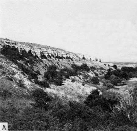
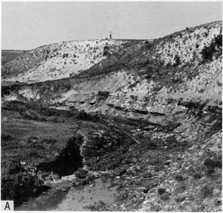
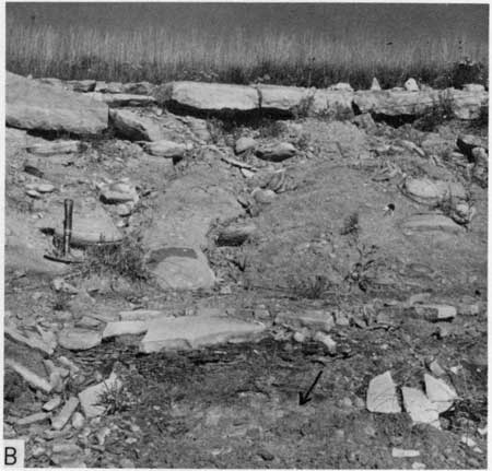
In central Kansas the Greenhorn outcrop trends almost exactly northeastward from the southern terminus in Ford County to the Nebraska border in Washington County and occupies parts of fifteen intervening counties (Fig. 1). The outcrop area is a maximum of 215 miles long and is approximately 50 miles wide across Ellsworth, Russell, and Ellis counties, measured perpendicular to the outcrop trend. The best natural exposures of the Greenhorn are along major drainage courses including from south to north, Pawnee River and its southern tributaries (Sawlog and Buckner Creeks), Walnut Creek, Smoky Hill River (Fig. 2,A) and one of its northern tributaries (Big Creek), Saline River and one of its northern tributaries (Wolf Creek), Solomon River and one of its southern tributaries (Salt Creek), Republican River and one of its southern tributaries (Buffalo Creek) and Mill Creek (a western tributary to Little Blue River). Road and dam construction has produced many excellent artificial exposures (Fig. 2,B), some of which span the entire thickness of the formation. Natural exposures are poor in much of the northern part of the outcrop area, owing to Pleistocene surface deposits and heavy vegetation, and in Barton and Pawnee counties owing largely to relatively gentle terrain.
Figure 1--Map of Kansas showing outcrop (diagonal ruling) of Greenhorn Limestone. Greenhorn Limestone crops out in counties named in large type.
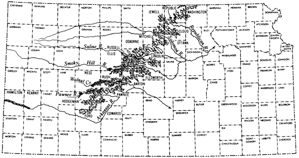
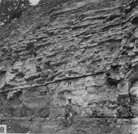
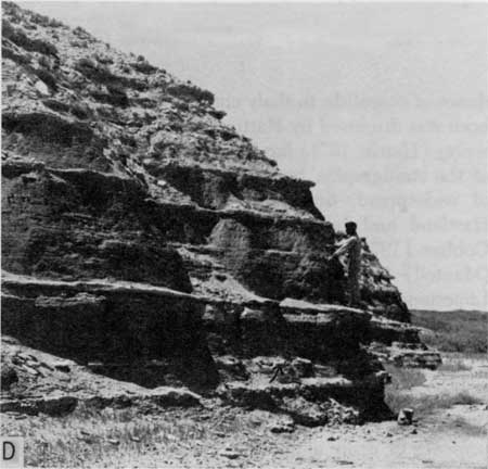
Figure 2--Characteristic exposures and topographic features of Greenhorn Limestone. A) Natural exposure of Greenhorn Limestone in bluff along north side of Smoky Hill River, sec. 18, T. 15 S., R. 15 W., Russell County (Loc. 40). Bluff is part of Greenhorn escarpment. Cliffs are formed by Jetmore Member; slope below is formed by Hartland Member. B) Cut on former route of Missouri Pacific Railroad at Glen Elder, sec. 27, T. 6 S., R. 9 W., Mitchell County (Loc. 63). Contact between Hartland and Jetmore Members is marked by the black line. C) View toward south across Saline River valley showing flat topography (distant uplands and at far left) developed on Greenhorn Limestone in interstream areas, sec. 2, T. 13 S., R. 11 W., Russell County (1/4 mi. E. of Loc. 28). Hills are part of Greenhorn escarpment. Shellrock bed forms bench indicated by arrow. D) Natural exposure of Bridge Creek Limestone Member on East Bridge Creek, sec. 14, T. 23 S., R. 42 W., Hamilton County (Loc. 14). Jim Cocke is standing on Shellrock limestone bed. Arrow marks beds of chalky limestone concretions.
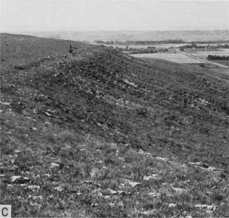
Interstream areas of the central Kansas outcrop are mostly flat to gently rolling uplands (Fig. 2,C) largely underlain by Greenhorn Limestone and the lower part of the Carlile Shale (Fairport Chalk Member), and are devoted extensively to the growing of wheat and other grain crops or to pasturage. Along the walls of larger streams, hilly terrain underlain by Greenhorn rocks is utilized chiefly as pasturage. Erosion has not produced notable landmarks in the Greenhorn outcrop, but hills along the Greenhorn escarpment, described below, add scenic interest to the landscape.
In western Kansas, the Greenhorn Limestone crops out mainly along the north bluffs of the Arkansas River in a slender belt approximately 40 miles long and extending from near Hartland, Kearny County, west-northwestward to the Colorado border. In addition small inliers have been mapped south of the river in Hamilton County (see Bass, 1926). The major outcrop reaches a maximum width of approximately two miles along valleys of northern tributaries to the Arkansas River; most exposures are natural, the best being along these tributaries (Fig. 2,D). Along the main outcrop the hilly terrain is devoted almost entirely to pasturage.
Table 1--Description of Localities. The first 24 localities listed below are those at which detailed stratigraphic sections were measured. The remaining localities (25 through 70) are sections of the Greenhorn that were examined for fossil content and supplementary stratigraphic detail. Thickness of selected marker beds and intervals between these marker beds were measured at localities 31, 36, 45, 47, 48, 50, 51, 56, 57, 58, 62, 64, 67, and 68.
| Locality Number |
Location | Description |
|---|---|---|
| 1 | SW SW sec. 27, T. 6 S., R. 9 W., Mitchell County. | Cut at north end of Glen Elder Dam at southwest corner of Glen Elder. Complete section. |
| 2 | West line, NW sec. 35, and east line NE sec. 34, T. 12 S., R. 14 W., Russell County. | Road cuts on U.S. Highway 281 shortly north of Saline River. Complete section. |
| 3 | West line, sec. 18, T. 13 S., R. 12 W., Russell County. | Road cuts on Luray-Bunker Hill road approximately 3 1/2 miles north of Bunker Hill. Complete section. |
| 4 | East line, SE SE sec. 24, T. 8 S., R. 6 W., Mitchell County. | Road cuts and quarry on north-south county road approximately 3 miles south of Simpson. Complete section. |
| 5 | N2 sec. 28, T. 15 S., R. 17 W., Ellis County. | Bluff on north side of Smoky Hill River approximately 2 1/2 miles WNW of Pfeifer. Complete section. ADJACENT TO PFEIFER TYPE SECTION. |
| 6 | South line, SW sec. 5 and north line, NW sec. 8, T. 3 S., R. 1 E., Washington County. | Road cuts on both sides of U.S. Highway 36 approximately 3 miles southwest of Haddam. Nearly complete section. |
| 7 | South line, SW SW sec. 4, T. 3 S., R. 1 W., Republic County. | Road cut on north side of U.S. Highway 36 approximately 3/4 mile northeast of Cuba. Upper part of Pfeifer Member. Sections at localities 6 and 7 comprise a complete composite section. |
| 8 | SW sec. 5, T. 25 S., R. 24 W., Ford County. | Cut bank and pasture on south side of Sawlog Creek approximately 10 miles north and 2 miles east of Dodge City. Lincoln Limestone Member; lower part of Hartland Member. |
| 9 | NW sec. 13, T. 23 S., R. 24 W., Hodgeman County. | Cut bank on intermittent stream approximately 1 1/2 miles southwest of Jetmore. Upper part of Hartland Member; Jetmore Member. |
| 10 | NE SE sec. 25, T. 21 S., R. 26 W., Hodgeman County. | Cut bank and abandoned fencepost quarry on south side of Pawnee Creek approximately 14 miles northwest of Jetmore. Upper 2/3 of Hartland Member; Pfeifer Member. |
| 11 | NE sec. 10, T. 23 S., R. 23 W., Hodgeman County. | Draw in south wall of Buckner Creek valley approximately 2 1/2 miles ESE of Jetmore. Middle part of Hartland Member. Sections at localities 8 through 11 comprise a complete composite section of the Greenhorn. |
| 12 | NE sec. 12, T. 25 S., R. 38 W., Kearny County. | Cut bank on southwest side of intermittent stream approximately 6 1/2 miles southeast of Kendall. Lincoln Member. |
| 13 | NE sec. 32, T. 24 S., R. 38 W., Kearny County. | Road ditch and bluff on northeast side of county road approximately 2 1/2 miles ESE of Kendall. Hartland Member. APPARENT TYPE SECTION OF HARTLAND. |
| 14 | SW sec. 14, NE,4 sec. 22, T. 23 S., R. 42 W., Hamilton County. | Cut banks on East Bridge Creek approximately 5 1/2 miles ENE of Coolidge. Bridge Creek Member. Sections at localities 12 through 14 comprise a complete composite section of the Greenhorn. |
| 15 | SW NE sec. 5, T. 19 S., R. 16 W., Rush County. | Cut banks and bluff on south side of Dry Walnut Creek approximately 5 miles southeast of Timken. Upper part of Hartland Member; Jetmore Member. |
| 16 | NW sec. 6, T. 20 S., R. 16 W., Pawnee County. | Bluff on east side of intermittent stream approximately 11 miles north and 2 miles west of Larned. Lincoln Member. |
| 17 | SW corner sec. 33, T. 18 S., R. 17 W., Rush County. | Cut bank on intermittent stream approximately 5 miles ESE of Rush Center. Upper part Lincoln Member; lower part of Hartland Member. |
| 18 | East line, SE NE sec. 21, T. 19 S., R. 18 W., Rush County. | Road cut on west side of U.S. Highway 183 approximately 5 1/2 miles south of Rush Center. Lower part Pfeifer Member. |
| 19 | SE SW sec. 1, T. 19 S., R. 17 W., Rush County. | Dry silo in bluff of Dry Walnut Creek approximately 3 1/2 miles SSE of Timken. Upper part of Pfeifer Member. Sections at localities 15 through 19 comprise a complete composite section of the Greenhorn. |
| 20 | NE SE sec. 12, T. 5 S., R. 7 W., Jewell County. | Road cuts on north-south county road and farm lane approximately 3/4 mile south of Randall. Nearly complete section. |
| 21 | Near center, sec. 21, T. 9 S., R. 8 W., Mitchell County. | Cut bank on south side of Rock Creek approximately 9 1/2 miles ENE of Hunter. Lincoln, Hartland, and Jetmore Members; lower part of Pfeifer Member. |
| 22 | SE SE sec. 20, T. 1 S., R. 2 W., Republic County. | Cut bank on tributary to Rose Creek approximately 9 miles NNE of Belleville. Upper part of Pfeifer Member. |
| 23 | NE SE sec. 11, T. 24 S., R. 22 W., Hodgeman County. | Cut bank on small tributary to Sawlog Creek approximately 10 miles south of Hanston. Lower part of Lincoln Member. |
| 24 | South line, SE SE sec. 31, T. 12 S., R. 10 W., Lincoln County. | Cut on north side of east-west county road approximately one mile east of Lake Wilson overflow spillway. Lincoln and Hartland Members; basal part of Jetmore Member. LINCOLN REFERENCE SECTION. |
| 25 | East line, NE SE sec. 5, T. 13 S., R. 15 W., Russell County. | Cut on west side of Fairport-Gorham road. Upper part of Hartland Member; Jetmore and Pfeifer Members. |
| 26 | NW NW sec. 4 and NE NE sec. 5, T. 12 S., R. 15 W., Russell County. | Cut bank on small tributary to Saline River and cut on Fairport-Gorham road approximately ll,2 miles east of Fairport. Lincoln and Hartland Members; lower part of Jetmore Member. |
| 27 | NE sec. 6, T. 14 S., R. 10 W., Ellsworth County. | Cut on west side of north-south county road approximately 2 1/2 miles north of Wilson. Lincoln, Hartland, Jetmore Members; lower part of Pfeifer Member. |
| 28 | NE sec. 3, T. 13 S., R. 11 W., Russell County. | Cut on west side of north-south county road approximately 8 miles NNE of Dorrance. Complete section. |
| 29 | West line, NE sec. 18, T. 11 S., R. 12 W., Russell County. | Cut on east side of north-south county road approximately 1/2 mile south of Luray. Lincoln and Hartland Members. |
| 30 | SE SW sec. 24, T. 22 S., R. 22 W., Hodgeman County. | Cut on east-west county road approximately 1 mile east of Hanston. Lower part of Lincoln Member. |
| 31 | NE sec. 21, T. 9 S., R. 8 W., Mitchell County. | Cut bank on Rock Creek approximately 9 3/4 miles ENE of Hunter. Part of Lincoln Member. |
| 32 | West line, SW sec. 30, T. 10 S., R. 7 W., and east line, SE sec. 25, T. 10 S., R. 8 W., Lincoln County. | Cuts on both sides of Kansas Highway 14 approximately 7 miles north of Lincoln. Part of Lincoln Member. |
| 33 | NW NW sec. 1 and NE NE sec. 2, T. 13 S., R. 13 W., Russell County. | Cuts on both sides of north-south county road approximately 5 1/2 miles north and I mile west of Bunker Hill. Jetmore Member. |
| 34 | East line, NE sec. 2, T. 14 S., R. 8 W., Ellsworth County. | Cut on Kansas Highway 14 approximately 9 miles NNE of Ellsworth. Upper part of Lincoln Member; lower part of Hartland Member. |
| 35 | South line, SW sec. 6 and north line, NW sec. 7, T. 12 S., R. 9 W., Lincoln County. | Cuts on both sides of Kansas Highway 18 approximately 1 1/2 miles northeast of Sylvan Grove. Upper art of Lincoln Member; Hartland and Jetmore Members; Easal part of Pfeifer Member. |
| 36 | South line, SE sec. 7 and north line, NE sec. 18, T. 10 S., R. 7 W., Lincoln County. | Cuts on both sides of east-west county road approximately 9 1/2 miles north and 1/2 mile east of Lincoln. Hartland, Jetmore and Pfeifer Members. |
| 37 | NE NE sec. 10, T. 7 S., R. 8 W., Mitchell County. | Bluff on south side of Solomon River approximately 1 mile south of Solomon Rapids. Upper part of Lincoln Member; Hartland Member; lower half of Jetmore Member. |
| 38 | NW NW sec. 26 and NE NE sec. 27, T. 14 S., R. 15 W., Russell County. | Cuts on both sides of north-south county road approximately 5 miles south and 3 miles east of Gorham. Nearly complete section of Lincoln Member; upper two thirds of Jetmore Member; lower two thirds of Pfeifer Member. |
| 39 | West line, NW sec. 3, T. 16 S., R. 10 W., Ellsworth County. | Cut on east side of north-south county road approximately 7 miles north and 1/2 mile west of Holyrod. Lower part of Lincoln Member. |
| 40 | SW sec. 18, T. 15 S., R. 15 W., Russell County. | North bluff of Smoky Hill River approximately 9 1/2 miles south and 1/2 mile west of Gorham. Lincoln, Hartland and Jetmore Members. |
| 41 | West line, SW NW sec. 27, T. 15 S., R. 18 W., Ellis County. | Cut on east side of U.S. Highway 183 approximately 1/2 mile northeast of Schoenchen. Upper part of Pfeifer Member. |
| 42 | West line, NW' sec. 5, T. 19 S., R. 17 W., Rush County. | Cut on east side of north-south county road approximately 4 1/2 miles SSE of Rush Center. Upper part of Hartland Member; lower two thirds of Jetmore Member. |
| 43 | SW SE sec. 32, T. 18 S., R. 17 W., Rush County. | Cut bank of intermittent stream and eroded pasture approximately 5 miles SSE of Rush Center Kansas. Upper part of Lincoln Member; upper two thirds of Hartland Member; lower part of Jetmore Member. |
| 44 | North line, NE sec. 30, T. 18 S., R. 20 W., Rush County. | Cut on south side of Kansas Highway 96 approximately 1 mile west of Alexander. Upper part of Jetmore; lower two thirds of Pfeifer Member. |
| 45 | NE SW sec. 14, T. 9 S., R. 5 W., Ottawa County. | Cut on county road near crest of Boyers Hill approximately 4 miles west of Delphos. Upper part of Lincoln Member; Hartland and Jetmore Members; lower part of Pfeifer Member. |
| 46 | South line, SE SE sec. 7 and NE NE sec. 18, T. 8 S., R. 3 W., Cloud County. | Cut on U.S. Highway 24, 1.1 miles west of junction with U.S. Highway 81. Upper part of Lincoln Member; Hartland and Jetmore Members; lower part of Pfeifer Member. |
| 47 | South line, SW SW sec. 22, T. 6 S., R. 3 W., Cloud County. | Cut on north side of east-west county road approximately 3 1/2 miles south of Concordia. Lincoln Member; lower part of Hart- land Member. |
| 48 | NE sec. 16, T. 6 S., R. 3 W., Cloud County. | Cut on east side of U.S. Highway 81, approximately 1 1/2 miles south of Concordia. Upper two thirds of Hartland Member; most of Jetmore Member. |
| 49 | Center of west line. sec. 21, T. 7 S., R. 7 W., Mitchell County. | Cut on east side of Kansas Highway 14 approximately 1 1/4 miles south of Beloit. Top bed of Jetmore Member; Pfeifer Member. |
| 50 | West line, NE sec. 7, T. 23 S., R. 23 W., Hodgeman County. | Cut on east side of north-south county road a proximately 1/4 mile south of Jetmore. Upper part of Hartland Member; Jetmore Member; lower part of Pfeifer Member. JETMORE TYPE SECTION. |
| 51 | West line, SW SWsec. 5, T. 25 S., R. 24 W., Ford County. | Cuts along north-south county road approximately 9 miles north and 1 mile east of Dodge City. Upper part of Hartland Member; lower part of Jetmore Member. |
| 52 | North line, NW NW sec. 16, T. 25 S., R. 25 W., Ford County. | Cut on east-west county road approximately 8 miles north and 3 miles west of Dodge City. Middle part of Jetmore Member. |
| 53 | Center, SW sec. 9, T. 25 S., R. 25 W., Ford County. | Cut bank and bluff on east side of Sawlog Creek approximately 9 miles north and 3 miles west of Dodge City. Upper two thirds of Hartland Member; Jetmore Member. |
| 54 | SW NW sec. 33, T. 18 S., R. 17 W., Rush County. | Cut bank on southern tributary to Walnut Creek. Lincoln Member. |
| 55 | East line, NW SW sec. 35, T. 24 S., R. 23 W., Hodgeman County. | Cut on north-south county road approximately 11 miles SSE of Jetmore. Lower half of Lincoln Member. |
| 56 | East line, SE SE sec. 1, T. 19 S., R. 22 W., Ness County. | Cut on west side of north-south county road approximately 1 mile south of Bazine. Upper two thirds of Jetmore Member; lower part of Pfeifer Member. |
| 57 | Center of west line, sec. 7, T. 19 S., R. 21 W., Ness County. | Cut on east side of north-south county road approximately 1 1/2 miles south of Bazine. Upper part of Pfeifer Member. |
| 58 | SW sec. 27, T. 18 S., R. 21 W., Ness County. | Cut on south side of Kansas Highway 96 approximately 2 1/2 miles east of Bazine. Jetmore Member. |
| 59 | NE SE sec. 2, T. 18 S., R. 12 W., Barton County. | Cut on Missouri-Pacific Railroad approximately 4 miles west and 3/4 mile south of Claflin. Lower part of Lincoln Member. |
| 60 | West line, NE SW sec. 32, T. 17 S., R. 14 W., Barton County. | Cut on north-south county road approximately 6 1/2 miles west of Hoisington. Lower part of Lincoln Member. |
| 61 | NW sec. 21, T. 15 S., R. 10 W., Ellsworth County. | Small southern tributary to Smoky Hill River. Lowermost Lincoln Member. |
| 62 | NW sec. 36, T. 12 S., R. 11 W., Russell County. | Cut on road at northwest end of Wilson Dam. Complete section. |
| 63 | SW sec. 27, T. 6 S., R. 9 W., Mitchell County. | Cut on former line of Missouri Pacific Railroad along south edge of Glen Elder. Upper part of Hartland Member; Jetmore Member; Pfeifer Member (essentially same as no. |
| 64 | SW NW sec. 23, T. 4 S., R. 6 W., Jewell County. | Stream bank and bluff on West Marsh Creek approximately 5 miles northeast of Randall. Poor exposure of Lincoln, Hartland, and Jetmore Members. |
| 65 | South line, SE SW sec. 3 and north line, NE NW sec. 10, T. 3 S., R. 3 W., Republic County. | Cuts on both sides of U.S. Highway 36 shortly east of junction with U.S. Highway 81 approximately one fourth mile west of Belleville. Jetmore Member; lower part of Pfeifer Member. |
| 66 | NE sec. 19 and SW NW sec. 20, T. 12 S., R. 12 W., Russell County. | Cuts on both sides of county road approximately 9 miles WSW of Lucas. Lincoln, Hartland, and Jetmore Members. |
| 67 | South line, SW SW sec. 4, T. 3 S., R. 1 W., Republic County. | Cut on north side of U.S. Highway 36 approximately 3/4 mile northeast of Cuba. Upper part of Hartland Member; Jetmore and Pfeifer Members. |
| 68 | S2 sec. 36, T. 13 S., R. 7 W., Lincoln County. | Cut on south side of Interstate 70 approximately 13 miles SSE of Lincoln. Complete section. |
| 69 | NE SE,4 sec. 7, T. 13 S., R. 14 W., Russell County. | Cut bank on east side of Canyon Road approximately 4 1/2 miles northeast of Russell. Lower half of Lincoln Member. |
| 70 | SW SE sec. 30, T. 11 S., R. 12 W., Russell County. | Cuts on east side of north-south county road and east-west county road approximately 3 1/2 miles south of Luray. Upper part of Jetmore Member, Pfeifer Member. |
| 71 | SW sec. 31, T. 15 S., R. 10 W., Ellsworth County. | Cut on west side of north-south county road approximately 8 1/2 miles south of Wilson. Upper part of Lincoln Member, Hartland Member, Jetmore Member, lower part of Pfeifer Member. |
General Geology
The Greenhorn Limestone has long been classified as part of the Colorado Group which in Kansas is divided as shown in Figure 3.
Figure 3--Stratigraphic classification of Colorado Group in central Kansas.
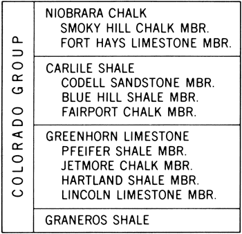
In Hamilton and Kearny counties rocks equivalent to the Pfeifer, Jetmore, and upper two thirds or more of the Hartland are included in a unit called Bridge Creek Limestone Member. [Note: At the recommendation of Dr. Hattin the Stratigraphic Names Committee of the Kansas Geological Survey has voted to accept the Bridge Creek Limestone Member as a formal name in Hamilton and Kearny counties.]
Throughout most of western Kansas the Greenhorn lies disconformably on the Graneros Shale (Hattin, 1965a, p. 11; 1968) but locally, as at Locality 6 (see Table 1 for a description of the localities) in Washington County, Locality 1 in Mitchell County, and in Kearny County (Loc. 12), this contact is conformable or nearly so. The Greenhorn is overlain conformably by Fairport rocks of the same lithology that have been excluded, incorrectly in my view, from the Greenhorn.
At the northeastern end of the central Kansas outcrop, in Washington and Republic counties, the Greenhorn is overlain locally by Pleistocene deposits. At the southern end of this outcrop, in Hodgeman and Ford counties, the Greenhorn is truncated by the east-dipping beds of the Ogallala Formation (Pliocene), especially in the vicinity of Sawlog Creek. At all other places studied by the writer, the Greenhorn underlies the present land surface or is overlain by younger Cretaceous strata.
In central Kansas the Greenhorn crops out in a northeast-trending belt that lies in the eastern part of the Blue Hills district of the Dissected High Plains (Schoewe, 1949, p. 309). Width of Greenhorn outcrop ranges from less than one-fourth mile in bluffs along larger streams, to several miles in interstream areas having gentle slopes such as north of the Smoky Hill River in Russell and Ellsworth counties, and adjacent to Walnut Creek in Rush County. The southeastern outcrop margin is marked by the intricately dissected Greenhorn escarpment (Figs. 2,A,C) which serves to define the boundary between Blue Hills and Smoky Hills. Relief at this escarpment is greatest along the valleys of the major streams which flow across the outcrop in a dominantly eastward direction. The escarpment is deeply embayed where these streams intersect the southeastern border of the outcrop. In these valleys local topographic relief commonly exceeds 200 feet at the northern and southern ends of the outcrop and is more than 300 feet along Saline River valley in northeastern Russell County and west of Delphos in Ottawa County. Near the southeastern edge of the outcrop, limestones in the Lincoln Member, the Shellrock limestone bed in the Jetmore Member, the Fencepost limestone bed in the Pfeifer Member, and the lowest persistent chalky limestone bed in the Fairport Member of the Carlile have served as major controls in the development of upland topography in bluffs adjacent to stream courses (Figs. 4,A,B,C). These same beds locally form well-developed benches below the upland level (Fig. 2,C). In some parts of the area outliers of the Greenhorn form prominent hills whose butte- or mesa-like profiles have been subdued because the bedrock is soft and the caprock thin. One of the more accessible of these hills is crossed by Interstate Highway 70 at Locality 68, Lincoln County.
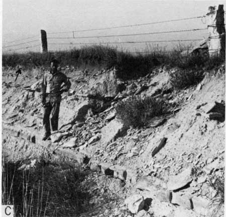
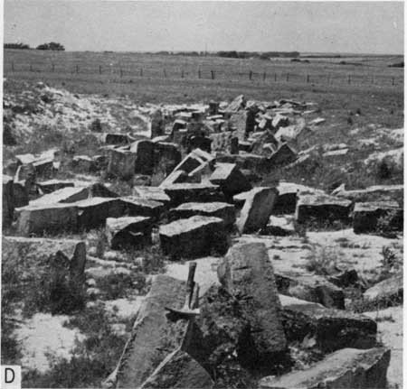
Figure 4--Features of the Greenhorn Limestone. A) Bluff held up by Lincoln Member, sec. 5, T. 25 S., R. 24 W., Ford County. B) Upland surface underlain directly by Fencepost limestone bed, sec. 3, T. 13 S., R. 11 W., Russell County (Loc. 28). Arrow marks position of sugar sand bed. C) Upland surface underlain directly by lowest persistent limestone bed (arrow) in Fairport Member, Carlile Shale, sec. 18, T. 13 S., R. 12 W., Russell County (Loc. 3). The bed beneath Jim Cocke's feet is Fencepost limestone. Note use of limestone posts in fence. D) Abandoned Fencepost limestone quarry, sec. 25, T. 21 S., R. 26 W., Hodgeman County (Loc. 10).
The full thickness of the Greenhorn is exposed in some steep bluffs along Saline and Smoky Hill Rivers or in artificial cuts at damsites and along roads that cross the Greenhorn Escarpment as at Localities 2, 3, 28 and 62 in Russell County, at Localities 1 and 4 in Mitchell County, and at Locality 68 in Lincoln County. The most striking natural exposures are in cliffs or steep bluffs held up by chalky limestone beds in the upper part of the formation; such exposures are numerous along nearly every major stream course. Because of the large number and close spacing of limestone and chalky limestone beds in the Jetmore, this member is the chief cliff-forming unit and is therefore the best-exposed part of the Greenhorn in central Kansas.
In Hamilton and Kearny counties the Greenhorn is exposed mainly in a narrow outcrop along the north side of Arkansas River. Here the river and its northerly tributaries have sliced through the Tertiary cover of the High Plains, thus exposing the underlying Cretaceous rocks in bluffs along the stream courses. Local relief in this area ranges from 150 to 180 feet, but the entire thickness of the Greenhorn is not exposed at any one locality. As in central Kansas, local benches are developed on limestones in the Lincoln Member and on the Shellrock and Fencepost beds in the upper part of the formation. A more prominent bench is developed on a thick chalky limestone marker bed that lies at the base of the Bridge Creek Member and that is equivalent to a bed in the Hartland Member that is referred to as HL-1 elsewhere in this report.
The top of the Greenhorn Limestone (Fencepost limestone bed) and, locally, the top of the Jetmore Member (Shellrock limestone bed) have been used as structural datum planes in some of the earlier maps of counties lying athwart the Greenhorn outcrop. As recorded on these maps local structural relief in the west-central Kansas outcrop is 10 to 12 feet per mile to the northwest in Republic and Cloud counties (Wing, 1930, p. 42), 10 to 15 feet per mile to the north in Osborne and Mitchell counties (Landes, 1930, p. 42), an average of 7 feet per mile in Russell County (Rubey and Bass, 1925, p. 66), 10 feet per mile just east of north in Ellis County (Bass, 1926, p. 42) and 10 feet per mile slightly east of north in Ness and Hodgeman counties (Moss, 1932, p. 40). Regional structure maps are not available for the Greenhorn of western Kansas but such maps have been compiled for the top of the Dakota Formation (Merriam, 1957a) and base of the Niobrara Chalk (Morrow, 1941). In the central Kansas area, regional dip at the top of the Dakota is 8 to 9 feet per mile to the north northeast or north; in Hamilton County this surface dips 21 feet per mile towards the northeast (Merriam, 1957). Average dip along a line extending from Hamilton County to northeastern Phillips County is 11.5 feet per mile to the northeast on top of the Dakota (Merriam, 1957a) and 10 feet per mile to the northeast at the base of the Niobrara (Morrow, 1941). Merriam (1958, p. 90) has noted that structure maps drawn on various datum surfaces show "essentially the same structure as that on top of the Dakota."
The regional structure of Cretaceous beds is complicated by numerous small anticlinal and synclinal features that have been described in several county reports and summarized by Jewett (1951) and Merriam (1963). Some of the named structures discernable in the Greenhorn outcrop are the Syracuse anticline (Hamilton County), Bazine anticline (Ford, Ness, and Hodgeman counties), Beeler anticline (Hodgeman and Ness counties), Pfeifer anticline (Ellis and Russell counties), Fairport-Natoma anticline (Ellis, Russell, and Osborne counties), Tipton anticline (Mitchell County), and Salt Creek structure (Mitchell County). Small normal faults are numerous in exposures of Niobrara Chalk through much of the outcrop. Similar faults are known in the Greenhorn but, as noted by Rubey and Bass (1925, p. 69) for Russell County, are less common therein. Bass (1926, p. 81) reported a fault in the Lincoln Member in Hamilton County. I have discovered an apparently faulted section in the lower part of the Greenhorn in NW sec. 7, T. 13 S., R. 9 W., Lincoln County. In his Ellis County report Bass (1926, p. 47) mentioned faults in the Greenhorn but did not indicate that he actually saw any in that county.
The Greenhorn Limestone has been used as a source of structural stone throughout the area of the Kansas outcrop (Fig. 4,D). Large numbers of public buildings, homes, and farm out-buildings have been constructed of blocks quarried largely from the Fencepost limestone bed and, to a lesser extent, from the Shellrock limestone bed. Even the most casual traveler can not fail to note the extensive use of stone for fenceposts (Fig. 4,C) throughout most of the central Kansas outcrop area. Like the building stone, these posts have been quarried mostly from the Fencepost bed but many were taken also from the Shellrock bed. The use of these limestone beds for purposes stated above, and also for stepping stones, watering troughs, tombstones, telephone poles, and clothesline poles is beautifully demonstrated at the Post Rock Museum in Lacrosse, Kansas. In an authentic pioneer home constructed of Greenhorn stone, a dedicated group of Rush County citizens has assembled materials for an excellent display that commemorates the role the "post rock" has played in the settlement of the eastern Great Plains. Muilenburg (1958) and Risser (1960, p. 92-94) have discussed the uses to which the Fencepost and Shellrock limestone beds have been put.
The Greenhorn has been used locally for riprap in small dams but is not a suitable material for that purpose (Bayne and Walters, 1959, p. 18; Byrne and others, 1948, p. 45). Greenhorn rocks have been used as a source of road metal throughout most of the Kansas outcrop (Byrne and others, 1948, p. 41). The formation is not an aquifer but, in a few areas, hand-dug wells produce water from weathered and/or fractured Greenhorn strata. Such water supplies are unreliable and the water is generally of poor quality. The potential use of Greenhorn carbonate rocks as a source material for the manufacture of rock wool has been described by Plummer (1937, p. 57-64; 1937a, p. 20-22). In Kansas the thickness of the Greenhorn Limestone ranges from 68.5 feet (Loc. 1) to 135.9 feet (Locs. 12, 13, and 14), averaging 94.8 feet for 11 measured sections. Five of these measured sections are composite.
Acknowledgments
I take keen pleasure in thanking my former students Dr. Craig B. Hatfield, Dr. Leslie Sponsel, Mr. Donald E. Hall, Dr. Robert W. Frey and Dr. Norman R. King, each of whom served for part of one summer as my field assistant. I would like also to thank Dr. Phil Heckel of the University of Iowa and Dr. James Cocke of East Tennessee State University for their help in a similar capacity. Special thanks are extended to Dr. Erle G. Kauffman, U.S. National Museum and Dr. W. A. Cobban, U.S. Geological Survey for checking my identifications of many of the Greenhorn mollusks and for opportunity to discuss in the field many aspects of Greenhorn paleontology and stratigraphy in other states. Mr. Myrl V. Walker of Fort Hays Kansas State College graciously arranged for the loan of specimens from the Sternberg Museum. X-ray analyses of bentonite samples and thin sections were made with the help of Dr. John B. Droste, Department of Geology, Indiana University, and chemical analyses of shaly chalk and chalky limestones were prepared by Indiana Geological Survey personnel under the direction of Mr. Richard K. Leininger; I thank both of these friends for these kindnesses. The use of scanning electron microscope facilities at the University of Illinois was arranged by Dr. W. W. Hay whose help and interest is gratefully acknowledged. Mr. Herschel Lentz arranged for my use of the scanning electron microscope at Indiana University. Technical assistance, including drafting, indoor photography, thin section preparation, and typing was furnished by the Department of Geology, Indiana University and I am thankful for this help. Lastly, I wish to thank my good friend Dr. Daniel F. Merriam, former Chief of Geologic Research, Kansas Geological Survey, whose enthusiasm and encouragement are largely responsible for the completion of this study.
Prev Page--Contents || Next Page--History of Nomenclature
Kansas Geological Survey, Geology
Placed on web June 5, 2010; originally published May 1975.
Comments to webadmin@kgs.ku.edu
The URL for this page is http://www.kgs.ku.edu/Publications/Bulletins/209/02_intro.html