Kansas Geological Survey, Bulletin 206, part 2, originally published in 1974
Originally published in 1974 as Kansas Geological Survey Bulletin 206, part 2. This is, in general, the original text as published. The information has not been updated.
The combined river and alluvial-aquifer systems are the principal source of water for municipal, industrial, and irrigation supplies along the Kansas River valley in northeast Kansas. This report presents current geologic and hydrologic information on the valley-fill deposits and provides quantitative information on ground-water conditions.
The depth to water in the valley-fill deposits ranges from 0 to 50 feet below land surface and averages about 25 feet. The valley-fill deposits contained about 1 million acre-feet of ground water in storage in 1967. Wells yielding more than 1,000 gallons per minute are common. Transmissivity ranges from 5,300 to 48,000 square feet per day and the long-term storage coefficient was estimated to average 0.15. The chemical quality of the ground water is suitable for most uses; however, the water is generally very hard and may contain as much as 58 milligrams per liter of total iron.
In the northeastern quarter of Kansas, the principal sources of water for municipal, industrial, and irrigation supplies are the combined river and alluvial-aquifer systems in the Kansas and Missouri River valleys. This report is concerned with ground water in the valley-fill deposits of the Kansas River. Although previous reports describing ground-water conditions are available for most of the area of study, current geologic and hydrologic information, as well as more quantitative information, is needed to enable engineers and administrators to make sound decisions regarding the development and management of the resource. The purpose of this report is to provide this quantitative information. The study is part of a continuing program of ground-water investigations in Kansas begun in 1937 by the State Geological Survey of Kansas and the U.S. Geological Survey, in cooperation with the Division of Water Resources of Kansas State Board of Agriculture and the Division of Environmental Health of the Kansas State Department of Health.
The Kansas River valley project (fig. 1) includes parts of the following 10 counties: Douglas, Geary, Jefferson, Johnson, Leavenworth, Pottawatomie, Riley, Shawnee, Wabaunsee, and Wyandotte. The west end of the area studied includes the reaches of the Republican River downstream from U.S. Highway 77 and of the Smoky Hill River downstream from Interstate Highway 1-70. The valley averages 2.6 miles wide and extends 138 miles from Junction City to Kansas City, Kans.; about 170 miles of river are included within this area. The surface area of the valley-fill deposits in the study area (pls. 1 and 2) is 360 square miles.
Figure 1--Index map of Kansas showing area described in this report and areas covered by other online geologic reports, as of Nov. 2008. For additional information, please visit the KGS Geology Information Page.
The topographic features pertinent to ground water in the study area are the broad flood plain of the Kansas River, the flat terraces bordering the flood plain, and the bluffs along the edge of the valley. The datum of the stream-gaging station at Fort Riley is 1,034.69 feet above mean sea level, and at Bonner Springs is 741.06 feet. Thus, the slope of the valley is about 2 feet per mile along the 148-mile reach of the river between the gages.
The information presented in this report results from the analysis of geologic and hydrologic data collected during 1966-69, data contained in published reports (see selected references), and data in the files of the U.S. Geological Survey and cooperating State agencies.
Information was collected on depth, depth to water, and yield for 1,134 wells and test holes. Well depths and depths to water, together with lithologic logs from 530 wells and test holes, were used to prepare the maps showing saturated thickness of the valley-fill deposits and configuration of the bedrock surface. Data from 55 wells or test holes were used to prepare the geologic sections (pls. 1 and 2).
Transmissivities were computed or estimated from data at 215 well sites. Transmissivity of the valley-fill deposits was computed from aquifer tests at 18 sites and was estimated from specific-capacity tests of wells at 197 sites.
Samples of water have been collected from 359 wells and test holes for complete chemical analysis since 1940. Of these, 126 were collected during this study.
Only a part of the collected data is included in this report as representative data. However, lithologic logs, complete tables of well and test-hole records, transmissivities estimated from specific-capacity tests, chemical analyses of water, and water levels in observation wells are retained in the offices of the State and U.S. Geological Surveys, Lawrence, Kan., and may be examined there.
In this report all wells and test holes are numbered according to the U.S. Bureau of Land Management system of land division. In this numbering system, the first set of digits of a well number indicates the township; the second set, the range; and the third set, the section in which the well is located. Sections are subdivided into quarter section, quarter-quarter section, and quarter-quarter-quarter section. The quadrants are lettered a, b, c, and d in a counterclockwise direction beginning in the northeast quadrant. Thus, the first letter denotes the 160-acre tract; the second, the 40-acre tract; and the third, the 10-acre tract. When more than one well is located within the same subdivision, the wells are numbered serially beginning with 2 in the order in which they were inventoried. In Pottawatomie County, for example, well 9-11E-32adb is in the NW SE NE of sec. 32, T. 9 S., R. 11 E. (fig. 2), and is the first well inventoried in that tract.
Figure 2--Well-numbering system used in this report.
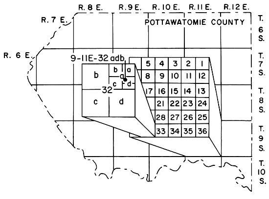
For the well-numbering system to apply to wells in the junction City area, a grid was assumed for the unsurveyed or irregularly shaped sections and townships. The light-weight dashed grid lines in this area are the assumed section lines.
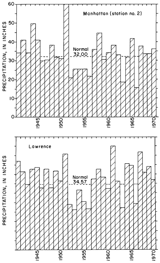
The normal annual precipitation at selected sites in the Kansas River valley is given in table 1, and the distribution with time of the rainfall at Lawrence and Manhattan is shown on figures 3 and 4. The data were obtained from records of the National Weather Service (formerly U.S. Weather Bureau).
Table 1--Normal annual precipitation in the Kansas River valley.
| Weather station | Normal precipitation (inches) |
|---|---|
| Junction City | 33.40 |
| Manhattan No. 2 | 32.00 |
| Wamego | 31.19 |
| Rossville | 32.42 |
| Topeka airport | 32.36 |
| Lawrence | 34.57 |
Figure 3--Normal monthly precipitation at Manhattan and Lawrence, 1931-60.
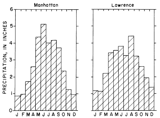
Figure 4--Annual precipitation at Manhattan and Lawrence, 1941-70.
[Note: The classification and nomenclature of the geologic units used in this report are those of the State Geological Survey of Kansas and differ somewhat from those of the U.S. Geological Survey.]
This report is concerned chiefly with the geology and the occurrence of ground water in valley-fill deposits (alluvium and terrace deposits) in the Kansas River valley. Except for small amounts of glacial drift of Pleistocene age that underlie the valley near Kansas City and Manhattan, the valley-fill deposits are underlain by rocks ranging in age from Pennsylvanian to Permian. The bedrock formations contribute small amounts of ground water to the valley-fill deposits in the Lawrence and Manhattan areas.
The alluvium adjacent to the Kansas River and the Newman and Buck Creek terrace deposits of Pleistocene age are the major geologic units in the valley. Deposits in buried channels on the bedrock surface, which may be Kansan in age, have not been differentiated from the alluvium and terrace deposits in this report. The important water-bearing materials are the sand and gravel in the alluvium and terrace deposits.
In general, the relative positions of the alluvium and terraces are as follows: alluvium occurs from the river to the first distinguishable escarpment toward the valley wall on either or both sides of the river; Newman terrace from the first escarpment to the next escarpment or change in soil texture toward the valley wall; and Buck Creek terrace adjacent to the valley wall or adjacent to the edge of the mapped area (pls. 1 and 2).
The lithology of the alluvium and the Newman terrace deposits is similar and grades upward from locally derived flat limestone pebbles and boulders on the bedrock surface to brownish-gray arkosic sand and gravel in the lower part to fine sand, silt, and silty clay in the upper part. The Buck Creek terrace deposits grade upward from brownish-yellow sand, sandy silt, and fine gravel in the lower part to reddish-brown and reddish-tan silt in the upper part.
The soils overlying the alluvium generally are tannish-brown sandy silt and silty sand. The soils of the Newman terrace (Davis and Carlson, 1952; O'Connor, 1960) were deposited on a flat surface and ,generally are poorly drained, silty, clayey, and black. The soils of the Buck Creek terrace are reddish-brown or reddish-tan silt and clay. Meander scars generally are prevalent on the soils overlying the alluvium and absent on the soils overlying the terrace deposits.
Detailed descriptions of the geology pertaining to the occurrence of ground water in the alluvium are given by: Lohman (1941), Fishel (1948), Latta (1949), Davis and Carlson (1952), Fishel, Searcy, and Rainwater (1953), Dufford (1958), Beck (1959), and O'Connor (1960, 1971). The reader is referred to these and other selected references for additional information.
Water levels in the area are shown by hydrographs for wells (fig. 5), profiles (fig. 6), and contours (pls. 1 and 2). Fluctuations in water levels are generally related to local recharge from precipitation, withdrawals by wells, and stages of the Kansas River. Short-term fluctuations are probably related to local recharge, and long-term fluctuations are more related to the stages of the streams. In general, water levels in wells are higher than the stages of the river at adjacent sites (fig. 6). Where ground water is pumped for irrigation, the water level may be lowered below the stage of the river in localized areas during dry summer months. However, this relationship is temporary, and water levels will quickly return to normal when pumping ceases. Water levels in the valley generally range from 0 to 50 feet below land surface and average about 25 feet.
Figure 5--Hydrographs for selected wells in valley-fill deposits and gage height corresponding to mean-monthly flow of the Kansas River at Topeka.
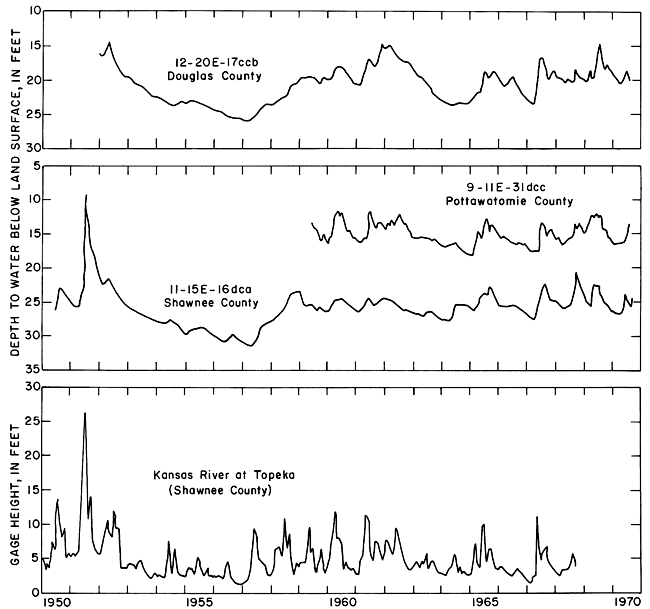
Figure 6--Selected water-level profiles in valley-fill deposits. Altitudes of the river near Silver Lake and Lawrence are extended from the nearest stream-gaging station.

In 1967, about 1 million acre-feet of ground water was in storage in the valley-fill deposits, which have a saturated thickness that ranges from 0 to 90 feet and averages 28 feet. The estimate of storage is based on a storage coefficient of 0.15 and the volume of saturated materials computed from plates 1 and 2.
Ground water for domestic and stock supplies generally is available everywhere in the Kansas River valley. Even where the saturated thickness is less than 20 feet, yields to wells of 500 gpm (gallons per minute) are possible locally. Where the saturated thickness is 20 to 40 feet, yields generally range from 300 to 1,000 rpm. In areas of more than 40 feet of saturated thickness, yields greater than 1,000 gpm are common. However, test drilling to locate the most permeable materials is recommended before a large-capacity well or a well field is installed.
Discharge from the valley-fill deposits is by seepage to major streams, evapotranspiration, and withdrawals by wells. Seepage to the Kansas River can be estimated if (1) base flow in the river is assumed to be from ground water, and (2) base flow is defined as the 90-percent-duration flow (Q90). From the curves by Furness (1959), Q90 is 718 cfs (cubic feet per second) at Wamego and 958 cfs at Bonner Springs. Tributaries contribute another 10 cfs; thus, the ground-water discharge in this reach of stream is about 230 cfs, or 2.2 cfs per mile. Based on this rate, the long-term average seepage to the Kansas River would be about 270,000 acre-feet per year for the study area. In 1956, the fifth year of well-below-normal precipitation, seepage to the river was about 1 cfs per mile in the reach between Wamego and Bonner Springs; in 1970, the fourth year of above-normal precipitation, seepage was about 4.3 cfs per mile. Thus, the ground-water contribution to the river following periods of low to nearly normal precipitation ranges from about 1 to 4 cfs per mile. The discharge by evapotranspiration was not estimated, but it may be about equal to the ground-water discharge to the stream.
Estimates of the withdrawals of ground water from the valley-fill deposits for irrigation, industrial, and municipal uses are given in table 2. These estimates were made from data reported to the Water Resources Division of the Kansas State Board of Agriculture and from additional information collected by the author. The total annual withdrawal ranged from 38,500 acre-feet in 1959 to 64,700 acre-feet in 1966. Based on the estimated annual seepage to the Kansas River of about 270,000 acre-feet per year, the annual withdrawal rate for 1966 could be increased about 4 times without adversely depleting the ground water in storage. However, local lowering of the water table would occur, seepage to the river would be reduced, and the present evapotranspiration rate would be reduced.
Table 2--Wididrawals of ground water by wells.
| County | Withdrawal, in acre-feet, for indicated year | ||||||||
|---|---|---|---|---|---|---|---|---|---|
| 1959 | 1960 | 1961 | 1962 | 1963 | 1964 | 1965 | 1966 | 1967 | |
| Douglas | 4,900 | 5,000 | 5,100 | 5,100 | 4,300 | 6,100 | 5,100 | 5,000 | 5,000 |
| Geary | 4,500 | 4,700 | 4,300 | 4,600 | 4,900 | 4,700 | 4,000 | 5,200 | 3,900 |
| Jefferson | 1,100 | 1,200 | 700 | 900 | 1,200 | 1,300 | 600 | 1,400 | 700 |
| Johnson | 800 | 1,000 | 800 | 800 | 1,000 | 1,900 | 1,100 | 1,300 | 1,800 |
| Leavenworth | 0 | 0 | 0 | 100 | 100 | 100 | 400 | 500 | 1,100 |
| Pottawatomie | 5,000 | 5,600 | 5,700 | 6,500 | 8,300 | 8,900 | 7,000 | 11,100 | 7,800 |
| Riley | 1,500 | 2,300 | 2,200 | 2,200 | 3,100 | 3,600 | 2,000 | 3,300 | 2,100 |
| Shawnee | 9,300 | 11,000 | 9,400 | 11,300 | 12,700 | 12,600 | 10,200 | 16,000 | 10,800 |
| Wabaunsee | 500 | 600 | 300 | 800 | 1,300 | 1,100 | 800 | 1,300 | 500 |
| Wyandotte | 10,900 | 10,700 | 13,900 | 19,400 | 21,200 | 21,400 | 21,700 | 19,600 | 20,500 |
| Total | 38,500 | 42,100 | 42,400 | 51,700 | 58,100 | 61,700 | 52,900 | 64,700 | 54,200 |
Recharge to the valley-fill deposits is by direct infiltration of precipitation on the valley, by seepage from streams and ponds, by return flow from irrigation, and by seepage from the shale, sandstone, and limestone that border and underlie the valley. The amount contributed from each of the above sources is not known, but the recharge over a long period of time is assumed to equal the discharge as the hydrologic system in the past has been in approximate equilibrium.
The quantity of water that an aquifer will yield to wells depends on the hydrologic properties of the aquifer material. The ability of an aquifer to transmit water is measured by the transmissivity (T), which is the rate at which water of the prevailing kinematic viscosity is transmitted through a unit width of saturated aquifer under a unit hydraulic gradient. The units for transmissivity are cubic feet per day per foot, which reduces to square feet (sq. ft.) per day. The term "transmissivity" replaces the term "coefficient of transmissibility," which was formerly used by the U.S. Geological Survey and which was reported in the inconsistent units of gallons per day per foot. To convert a value for coefficient of transmissibility to the equivalent value of transmissivity, multiply by 0.134; to convert from transmissivity to coefficient of transmissibility, multiply by 7.48.
The storage coefficient (S) of an aquifer is defined as the volume of water it releases or takes into storage per unit surface area per unit change in the component of head normal to that surface. The storage coefficient for unconfined-aquifer conditions is practically equal to the specific yield, which is defined as the ratio of the volume of water that a saturated material will yield by gravity to its own volume.
The results of 18 aquifer tests that were analyzed using standard formulas outlined by Wenzel (1942), Bentall (1963), and Ferris and others (1962) are given in table 3. Transmissivities from these tests range from 5,300 to 48,000 sq. ft. per day; transmissivities estimated from specific-capacity tests of wells are as large as 59,000 sq. ft. per day. The storage coefficients determined by the tests range from 0.0005 to 0.20. Coefficients in the low end of the range are from short-duration tests. If all tests had been conducted for several days, the resulting storage coefficients probably would range from 0.05 to 0.20 and average about 0.15.
Table 3--Results of aquifer tests in valley-fill deposits.
| Well number |
Date of test |
Duration of test (min.) |
Average well yield (gpm) |
Transmissivity (sq. ft. per day) |
Storage coefficient |
Remarks |
|---|---|---|---|---|---|---|
| Douglas County | ||||||
| 12-19E-1dbc | Nov. 1955 | 145 | 780 | 47,200 | 0.0005 | Observation well at 400 feet |
| 12-20E-29aca | June 1955 | 30 | 200 | 5,300 | .006 | Observation well at 26 feet |
| 12-20E-35ccc3 | Jan. 1968 | 7,000 | 1,000 | 19,600 | .043 | Observation wells at 48 and 103 feet |
| 13-20E-2bcb | Aug. 1963 | 780 | 1,090 | 17,400 | .003 | Observation wells at 40 and 80 feet |
| Johnson County | ||||||
| 12-22E-24ccc2 | June 1964 | 1,100 | 1,000 | 18,700 | Observation wells at 25, 75, 250, and 500 feet | |
| 25bbc | June 1964 | 1,460 | 1,080 | 24,000 | .05 | Observation wells at 25, 75, 250, and 250 feet |
| Pottawatomie County | ||||||
| 10-8E-8cac2 | Aug. 1952 | 183 | 1,330 | 36,000 | .20 | Observation wells at 131, 218, 384, and 588 feet |
| 10-8E-8daa2 | Jan. 1969 | 5,760 | 2,520 | 47,000 | .13 | Observation wells at 50, 50, 100, 100, 100, 200, 200, 500, 500, and 1,000 feet |
| 10- 9E-13dcb | Aug. 1967 | 52 | 615 | 38,100 | ||
| Riley County | ||||||
| 10-8E-4dbb | July 1965 | 17,300 | Two observation wells (Henry Beck, oral commun., 1966) | |||
| Shawnee County | ||||||
| 10-13E-30baa | Aug. 1953 | 16,000 | ||||
| 11-13E-3dbd | July 1956 | 780 | 850 | 24,300 | .02 | Observation wells at 60 and 90 feet |
| 11-15E-7cdc | July 1966 | 620 | 700 | 14,700 | .02 | Observation wells at 19 and 100 feet |
| 11-15E-13dac | Jan. 1958 | 1,440 | 225 | 48,000 | .09 | Observation wells at 110 and 270 feet |
| Wyandotte County | ||||||
| 11-24E-21ddd | Mar. 1960 | 4,320 | 525 | 22,100 | .12 | Observation wells at 50, 150, 300, 400, and 400 feet |
| 11-24E-29cdc | Dec. 1959 | 4,320 | 610 | 18,600 | .18 | Observation wells at 50, 150, 300, 300, 395, 445, and 500 feet |
| 11-24E-31dab | Jan. 1960 | 4,320 | 560 | 18,200 | .11 | Observation wells at 45, 144, 198, 300, 382, 422, and 500 feet |
| 11-24E-32aba | Feb. 1959 | 4,320 | 740 | 32,000 | .18 | Observation wells at 50, 100, 125, 276, 300, 300, 487, and 550 feet |
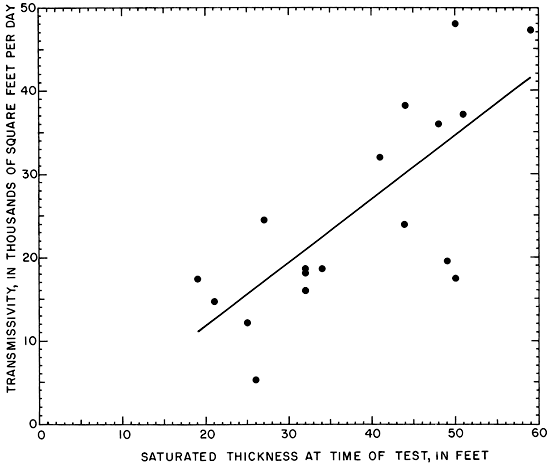
A plot of transmissivity and saturated thickness at the aquifer-test sites is shown on figure 7. A least-squares fit of the data gives a line with an intercept of -3,280 sq. ft. per day and a standard error of estimate of 8,960 sq. ft. per day (about 35 percent at the average transmissivity of 25,800 sq. ft. per day). For the range of data shown, figure 7 can be used to approximate the transmissivity at any given site where the saturated thickness is known. For example, the altitude of the water table at the SW cor. sec. 25, T. 10 S., R. 12 E., is 914 feet (pl. 1) and the altitude of the bedrock surface is 873 feet. The difference in water-table and bedrock altitudes, 41 feet, is the saturated thickness. From figure 7, the transmissivity at the site is estimated to be about 28,000 sq. ft. per day.
Figure 7--Relation of transmissivity to saturated thickness.
Water in the valley-fill deposits is generally very hard; it contains total iron in concentrations that range from 0.00 to 58 mg/l (milligrams per liter) The water is usable for most industrial, municipal, irrigation, stock, and domestic purposes, except in the area of and downstream from the East Kansas Avenue Bridge (23rd Street) in Kansas City, Wyandotte County, where the water contains a concentration of chloride as great as 4,000 mg/l. Maximum and minimum concentrations of selected constituents for all samples of water collected from the valley-fill deposits since 1940 are given (by county) in table 4.
Table 4--Maximum and minimum concentrations, in milligrams, per liter, of selected chemical constituents by county for all samples of water collected from valley-fill deposits since 1940.
| County | Dissolved solids | Calcium and magnesium hardness |
Chloride | Total iron | ||||||||
|---|---|---|---|---|---|---|---|---|---|---|---|---|
| Max. | Min. | Avg. | Max. | Min. | Avg. | Max. | Min. | Avg. | Max. | Min. | Avg. | |
| Douglas | 990 | 318 | 551 | 740 | 220 | 460 | 150 | 1.5 | 29 | 49 | 0.00 | 4.4 |
| Geary | 709 | 324 | 470 | 470 | 170 | 340 | 84 | 3.0 | 28 | 2.9 | .00 | .40 |
| Jefferson | 576 | 230 | 385 | 470 | 190 | 310 | 30 | 5.0 | 14 | 21 | .00 | 4.8 |
| Johnson | 553 | 365 | 463 | 450 | 260 | 410 | 66 | 7.0 | 17 | 25 | .00 | 7.2 |
| Leavenworth | 549 | 155 | 450 | 480 | 280 | 370 | 74 | 6.0 | 21 | 18 | .00 | 6.0 |
| Pottawatomie | 790 | 307 | 483 | 590 | 160 | 360 | 160 | 8.0 | 47 | 23 | .00 | 4.1 |
| Riley | 704 | 360 | 515 | 630 | 200 | 410 | 110 | 6.0 | 33 | 38 | .00 | 3.6 |
| Shawnee | 1,070 | 353 | 457 | 660 | 170 | 370 | 110 | 5.0 | 26 | 11 | .00 | 5.9 |
| Wabaunsee | 599 | 354 | 485 | 500 | 270 | 360 | 86 | 10 | 29 | 12 | .00 | 2.9 |
| Wyandotte | 7,270 | 353 | 1,050 | 1,500 | 210 | 560 | 4,000 | 7.0 | 250 | 58 | .00 | 12 |
Water samples for chemical analysis have been collected from 359 wells and test holes in the study area since 1940. Selected analyses are given in table 5.
Table 5--Chemical analysis of water from selected wells. [Analyses given in milligrams per liter, except as indicated. Analyses by Kansas State Department of Health.]
| Well number |
Depth (feet) |
Geologic source1 |
Date of collection |
Temp. (° C) |
Dissolved solids (evaporated at 180° C) |
Silica (SiO2) |
Total iron (Fe) |
Total Manganese (Mn) |
Calcium (Ca) |
Magnesium (Mg) |
Sodium and potassium (Na+K) |
Bicarbonate (HCO3) |
Sulfate (SO4) |
Chloride (Cl) |
Fluoride (F) |
Nitrate2 (NO3) |
Hardness3 as CaCO3 | Specific conductance (micromhos at 25° C) |
pH | |
|---|---|---|---|---|---|---|---|---|---|---|---|---|---|---|---|---|---|---|---|---|
| Calcium, Magnesium |
Non- carbonate |
|||||||||||||||||||
| Douglas County | ||||||||||||||||||||
| 12-19E-13dda | 52 | Qal | 5-23-1966 | 14.5 | 446 | 30 | 14 | 1.6 | 110 | 19 | 34 | 420 | 12 | 34 | 0.2 | 3.5 | 340 | 1 | 730 | 8.0 |
| 12-20E-8bcb | 82 | Qn | 4-25-1966 | 14.0 | 340 | 24 | 2.6 | .61 | 93 | 13 | 14 | 332 | 26 | 5.0 | .1 | 1.3 | 290 | 14 | 550 | 7.4 |
| 12-20E-29aad | 56 | Qal | 11-15-1966 | 14.5 | 360 | 31 | 5.9 | .27 | 100 | 9.7 | 16 | 322 | 25 | 18 | .3 | .4 | 290 | 28 | 560 | 7.4 |
| Geary County | ||||||||||||||||||||
| 11-6E-30caa | 70 | Qal | 1-9-1968 | 12.0 | 383 | 26 | .22 | 70 | 277 | 60 | 23 | .5 | .6 | 240 | 13 | 620 | 7.6 | |||
| 12-5E-1bba | 67 | Qal | 4-1-1960 | 24.0 | 452 | 27 | .16 | .2 | 90 | 17 | 37 | 285 | 35 | 29 | 27 | 290 | 190 | 450 | 7.7 | |
| Jefferson County | ||||||||||||||||||||
| 11-17E-20cac | 70 | Qn | 4-8-1966 | 14.0 | 576 | 26 | 2.3 | .87 | 150 | 20 | 22 | 376 | 140 | 30 | .2 | .9 | 470 | 160 | 880 | 7.6 |
| 11-18E-26ccd | 57 | Qal | 5-26-1966 | 14.5 | 389 | 32 | 8.0 | 1.0 | 110 | 15 | 11 | 376 | 28 | 6.0 | .2 | 2.7 | 330 | 26 | 600 | 7.9 |
| 11-19E-27bcc | 33 | Qb | 12-2-1950 | 14.0 | 230 | 12 | .35 | 61 | 5.4 | 11 | 181 | 12 | 9.0 | .1 | 30 | 170 | 26 | |||
| Johnson County | ||||||||||||||||||||
| 11-23E-33acc | 51 | Qal | 7-1-1944 | 15.0 | 365 | 10 | 100 | 14 | 6.7 | 265 | 82 | 16 | .1 | 1.3 | 310 | 94 | ||||
| 12-22E-29bbd | 46 | Qal | 5-11-1967 | 14.5 | 480 | 26 | 12 | .61 | 140 | 11 | 16 | 407 | 70 | 11 | .2 | 4.2 | 400 | 63 | 730 | 7.6 |
| Leavenworth County | ||||||||||||||||||||
| 12-22E-20cad | 48 | Qal | 5-16-1967 | 14.5 | 460 | 23 | 3.9 | .20 | 140 | 11 | 9.6 | 420 | 56 | 8.0 | .2 | 1.3 | 400 | 60 | 730 | 7.6 |
| 12-22E-28aaa | 62 | Qal | 5-15-1967 | 15.0 | 461 | 24 | 11 | .41 | 130 | 9.1 | 26 | 356 | 59 | 39 | .2 | 1.5 | 350 | 60 | 730 | 7.8 |
| Pottawatomie County | ||||||||||||||||||||
| 9-11E-30bbd | 90 | Qn | 5-5-1966 | 14.0 | 612 | 28 | 8.7 | .58 | 140 | 25 | 50 | 568 | 74 | 13 | .1 | 1.8 | 460 | 0 | 910 | 7.4 |
| 10-8E-13aad | 50 | Qn | 8-19-1967 | 15.0 | 471 | 27 | 4.5 | .62 | 120 | 19 | 33 | 425 | 34 | 31 | .1 | 1.3 | 370 | 22 | 770 | 7.5 |
| 10-8E-14cba | 69 | Qn | 3-29-1967 | 18.5 | 536 | 16 | 4.3 | .86 | 110 | 19 | 63 | 285 | 89 | 100 | .1 | 1.5 | 340 | 110 | 900 | 7.5 |
| 10-9E-14dcb | 65 | Qn | 6-23-1966 | 376 | 63 | .03 | .31 | 110 | 12 | 16 | 339 | 41 | 10 | .2 | 1.3 | 310 | 36 | 600 | 7.6 | |
| Riley County | ||||||||||||||||||||
| 9-8E-30dac | 79 | Qn | 3-30-1967 | 15.0 | 469 | 19 | 2.7 | 1.6 | 120 | 21 | 19 | 425 | 54 | 19 | .2 | 1.5 | 400 | 50 | 770 | 7.5 |
| 10-7E-35aad | 46 | Qal | 7-5-1966 | 16.5 | 618 | 26 | 4.3 | 2.0 | 110 | 16 | 99 | 383 | 84 | 97 | .3 | 1.5 | 330 | 16 | 1,010 | 7.8 |
| Shawnee County | ||||||||||||||||||||
| 11-14E-9cad | 47 | Qn | 9-7-1967 | 384 | 30 | .01 | .00 | 100 | 8.8 | 20 | 307 | 40 | 13 | .1 | 20 | 290 | 36 | 590 | 7.5 | |
| 11-15E-13cbc | 77 | Qn | 4-8-1966 | 14.0 | 480 | 26 | 3.8 | .57 | 130 | 17 | 23 | 368 | 80 | 26 | .2 | .9 | 280 | 82 | 740 | 7.6 |
| 11-15E-24bdd | 53 | Qal | 4-8-1966 | 14.5 | 684 | 23 | 1.1 | .66 | 180 | 20 | 29 | 420 | 190 | 28 | .2 | 6.2 | 530 | 180 | 1,020 | 7.4 |
| Wabaunsee County | ||||||||||||||||||||
| 10-10E-16abb | 43 | Qal | 3-24-1967 | 15.0 | 354 | 23 | 3.5 | 1.2 | 93 | 16 | 15 | 312 | 30 | 22 | .2 | .4 | 300 | 42 | 580 | 7.5 |
| Wyandotte County | ||||||||||||||||||||
| 11-24E-13bad | 75 | Qal | 7-29-1968 | 15.5 | 710 | 25 | 21 | 2.8 | 180 | 18 | 26 | 393 | 180 | 55 | .2 | 1.1 | 530 | 210 | 1,050 | 7.6 |
| 11-24E-22caa | 64 | Qal | 4-4-1967 | 15.0 | 639 | 26 | .00 | .15 | 170 | 12 | 39 | 381 | 130 | 65 | .1 | 6.2 | 480 | 160 | 1,020 | 7.4 |
| 11-25E-11ccc | 80 | Qal | 11-23-1943 | 16.0 | 4,120 | 10 | 170 | 25 | 1,400 | 786 | 170 | 1,900 | .2 | 42 | 520 | 0 | ||||
| 11-25E-11ccc2 | 80 | Qal | 11-4-1966 | 16.0 | 3,730 | 25 | 12 | .00 | 280 | 24 | 1,000 | 649 | 430 | 1,500 | .3 | 13 | 800 | 260 | 6,210 | 7.3 |
| 11-25E-15aba | 71 | Qal | 11-4-1966 | 15.5 | 3,720 | 33 | 30 | 1.5 | 330 | 57 | 1,000 | 742 | 310 | 1,600 | .2 | 1.5 | 1,100 | 460 | 6,210 | 7.5 |
| 11-25E-15ccc | 57 | Qal | 9-22-69 | 15.5 | 1,050 | 23 | 1.4 | .35 | 220 | 19 | 110 | 417 | 290 | 150 | .2 | .7 | 620 | 280 | 1,640 | 7.6 |
| U.S. Public Health Service (1962) recommended maximum concentrations for drinking water |
500 | .3 | .05 | 250 | 250 | 45 | ||||||||||||||
| 1. Qal, alluvium; Qb, Buck Creek terrace deposits; Qn, Newman terrace deposits. 2. In areas where the nitrate content of water is known to exceed 45 mg/l, the public should be warned of the potential dangers of using the water for infant feeding (U.S. Public Health Service, 1962, p. 7). 3. The U.S, Geological Survey uses the following classification for hardness: 0-60, soft; 61-120, moderately hard; 121-180, hard; more than 180, very hard. |
||||||||||||||||||||
The depth to water in valley-fill deposits of the Kansas River valley ranges from 0 to 50 feet below land surface and averages about 25 feet. Water levels in wells are generally higher than the stages of the river at adjacent sites.
The saturated thickness of the valley-fill deposits is as much as 90 feet and averages 28 feet. These deposits contained about 1 million acre-feet of ground water in 1967. Large quantities of ground water are available and wells yielding more than 1,000 gpm are common.
The annual rate of withdrawal of ground water in the Kansas River valley ranged from 38,500 acre-feet in 1959 to 64,700 acre-feet in 1966. The withdrawal rate for 1966 probably could be increased as much as 4 times without adversely depleting the ground water in storage.
Data compiled in the report indicate that the transmissivity ranges from 5,300 to 48,000 sq. ft. per day. The long-term storage coefficient is estimated to average 0.15.
Except for the area downstream from the East Kansas Avenue Bridge (23rd Street) in Kansas City, the chemical quality of the ground water is suitable for most uses. However, the water is generally very hard and may contain as much as 58 mg/l of total iron.
Logs of six test holes drilled in the Kansas River valley were selected as representative of the types of material in the valley-fill deposits. The logs are given in downstream order. The test holes were drilled by the State and U.S. Geological Surveys; samples were examined by a geologist or hydrologist during drilling.
| 11-7E-7bbd--Log of test hole in Riley County in the SE NW NW sec. 7, T. 11 S., R. 7 E., about 1,330 feet north and 670 feet east of W/4 cor. sec. in west road ditch; angered August 25, 1969. Altitude of land surface, 1,048 feet. | Thickness, feet |
Depth, feet |
||
|---|---|---|---|---|
| Quaternary System--Pleistocene Series | ||||
| Alluvium | ||||
| Topsoil, silty, black | 2 | 2 | ||
| Sand, fine, brown | 2 | 4 | ||
| Sand, very fine, tan | 8 | 12 | ||
| Silt, clayey, sandy, black | 3 | 15 | ||
| Silt, sandy, clayey, brownish-black | 10 | 25 | ||
| Sand, very fine, silty, gray | 3 | 28 | ||
| Clay, silty, blue; some coarse sand | 3 | 31 | ||
| Sand, silty; some bluish-gray gravel | 6 | 37 | ||
| Sand, coarse, and gravel, bluish-gray; some silt and clay | 5 | 42 | ||
| Sand, coarse, and gravel, bluish-gray | 13 | 55 | ||
| Gravel, coarse sand, and flat limestone pebbles, grayish-brown | 15 | 70 | ||
| Permian System | ||||
| Shale, weathered, whitish-yellow | 0+ | 70+ | ||
| 10-8E-23caa--Log of test hole in Riley County in the NE NE SW sec. 23, T. 10 S., R. 8 E., about 40 feet south and 20 feet west of center of section; angered August 20, 1969. Altitude of land surface, 997 feet. | Thickness, feet |
Depth, feet |
||
|---|---|---|---|---|
| Quaternary System--Pleistocene Series | ||||
| Alluvium | ||||
| Topsoil, silty, black | 2 | 2 | ||
| Sand, fine, silty, brown | 15 | 17 | ||
| Clay, silty, blue; contains silt layers | 4 | 21 | ||
| Sand, very fine, silty, gray | 8 | 29 | ||
| Sand, fine, gray | 5 | 34 | ||
| Sand, fine to medium, gray | 11 | 45 | ||
| Sand, medium to coarse; some pea gravel | 7 | 52 | ||
| Sand, coarse, and fine gravel, gray | 12 | 64 | ||
| Permian System | ||||
| Shale, blue | 1+ | 65+ | ||
| 11-14E-14daa--Log of test hole in NE NE SE sec. 14, T. 11 S., R. 14 E., about 300 feet south and 20 feet west of E4 cor. sec.; augered August 29, 1969. Altitude of land surface, 904 feet. | Thickness, feet |
Depth, feet |
||
|---|---|---|---|---|
| Quaternary System--Pleistocene Series | ||||
| Newman terrace deposits | ||||
| Topsoil, silty, black | 3 | 3 | ||
| Clay, silty, brown | 7 | 10 | ||
| Silt, sandy, clayey, tan | 6 | 16 | ||
| Sand, fine, silty, and silty clay layers, tan | 4 | 20 | ||
| Sand, fine, silty, clayey, tan | 15 | 35 | ||
| Sand, fine, silty, clayey, gray | 5 | 40 | ||
| Sand, medium, silty, gray, and pea gravel | 10 | 50 | ||
| Pennsylvanian System | ||||
| Wabaunsee Group | ||||
| Shale, gray | 2+ | 52+ | ||
| 11-17E-27cbb--Log of test hole in Shawnee County in the NW NW SW sec. 27, T. 11 S., R. 17 E., about 2,400 feet north of SW cor. sec.; augered August 1969. Altitude of land surface, 860 feet. | Thickness, feet |
Depth, feet |
||
|---|---|---|---|---|
| Quaternary System--Pleistocene Series | ||||
| Alluvium | ||||
| Sand, coarse, tan | 5 | 5 | ||
| Sand, coarse, silty, brown | 4 | 9 | ||
| Sand, fine to medium, tan | 14 | 23 | ||
| Sand, coarse, tan | 11 | 34 | ||
| Sand, coarse, and some pea gravel, grayish-brown | 10 | 44 | ||
| Sand, coarse, and pea gravel, silty, gray | 8 | 52 | ||
| Gravel, fine, silty, gray | 18 | 70 | ||
| Gravel and flat limestone pebbles | 7 | 77 | ||
| Pennsylvanian System | ||||
| Shale, blue | 1+ | 78+ | ||
| 12-19E-1ddd--Log of test hole in SE SE SE sec. 1, T. 12 S., R. 19 E., about 60 feet west and 40 feet north of SE cor. sec.; augered May 24, 1966. Altitude of land surface, 837 feet. | Thickness, feet |
Depth, feet |
||
|---|---|---|---|---|
| Quaternary System--Pleistocene Series | ||||
| Newman terrace deposits | ||||
| Topsoil, silty, black | 4 | 4 | ||
| Silt, clayey, black | 3 | 7 | ||
| Clay, silty, brown-black | 5 | 12 | ||
| Silt, clayey, tan | 2 | 14 | ||
| Sand, fine, silty, brown | 3 | 17 | ||
| Clay, silty, tan | 9 | 26 | ||
| Silt, clayey, tan | 4 | 30 | ||
| Clay, blue | 3 | 33 | ||
| Silt, clayey, brown | 2 | 35 | ||
| Sand, fine to medium, clayey, gray | 5 | 40 | ||
| Sand, coarse, clayey, gray | 6 | 46 | ||
| Sand and gravel, brown-gray | 9 | 55 | ||
| Clay, blue | 1 | 56 | ||
| Gravel, brown (well did not penetrate to bedrock at an estimated 85 feet) | 22+ | 78+ | ||
| 12-22E-24bbc--Log of test hole in Johnson County in the SW NW NW sec. 24, T. 12 S., R. 22 E., about 1,350 feet north and 20 feet east of W/4 cor. sec.; augered July 24, 1968. Altitude of land surface, 783 feet. | Thickness, feet |
Depth, feet |
||
|---|---|---|---|---|
| Quaternary System--Pleistocene Series | ||||
| Alluvium | ||||
| Sand, fine, tan | 5 | 5 | ||
| Sand, fine, silty, tan | 7 | 12 | ||
| Sand, fine, tan | 3 | 15 | ||
| Silt, sandy, tan | 2 | 17 | ||
| Sand, fine to medium, tan | 3 | 20 | ||
| Sand, medium to coarse, tan | 5 | 25 | ||
| Sand, coarse, and medium gravel | 15 | 40 | ||
| Gravel, medium, gray | 14 | 54 | ||
| Gravel, silty, gray | 3 | 57 | ||
| Pennsylvanian System | ||||
| Shale, blue | 0+ | 57+ | ||
Each plate contains two maps:
Beck, H. V., 1959, Geology and ground-water resources of the Kansas River valley between Wamego and Topeka vicinity: Kansas Geol. Survey, Bull. 135, 88 p. [available online]
Beede, J. W., 1898, The stratigraphy of Shawnee County: Kansas Acad. Sci., Trans., v. 15, p. 27-34.
Bennett, John, 1896, A geologic section along the Kansas River from Kansas City to McFarland: Kansas Univ. Geol. Survey, v. 1, p. 107-124.
Bentall, Ray, 1963, Methods of determining permeability, transmissibility, and drawdown: U.S. Geol. Survey, Water-Supply Paper 1536-I, p. 243-341. [available online]
Dabiri, H. E., Green, D. W., and Winslow, J. D., 1970, Digital computer simulation of an aquifer; in, Proceedings of 1970 Summer Computer Simulation Conference, Denver, Colo., p. 944-954.
Davis, S. W., and Carlson, W. A., 1952, Geology and ground-water resources of the Kansas River valley between Lawrence and Topeka, Kansas: Kansas Geol. Survey, Bull. 96, pt. 5, p. 201-276. [available online]
Dufford, A. E., 1958, The Quaternary geology and ground-water resources of Kansas River valley between Bonner Springs and Lawrence, Kansas: Kansas Geol. Survey, Bull. 130, pt. 1, 96 p. [available online]
Ferris, J. G., Knowles, D. B., Brown, R. H., and Stallman, R. W., 1962, Theory of aquifer tests: U.S. Geol. Survey, Water-Supply Paper 1536-E, p. 69-174. [available online]
Fishel, V. C., 1948, Ground-water resources of the Kansas City, Kansas, area: Kansas Geol. Survey, Bull. 71, 109 p. [available online]
Fishel, V. C., Searcy, J. K., and Rainwater, F. H., 1953, Water resources of the Kansas City area, Missouri and Kansas: U.S. Geol. Survey, Circ. 273, 52 p. [available online]
Frye, J. C., and Leonard, A. B., 1952, Pleistocene geology of Kansas: Kansas Geol. Survey, Bull. 99, 230 p. [available online]
Furness, L. W., 1959, Flow duration, pt. 1 of Kansas streamflow characteristics: Kansas Water Resources Board Tech. Rept. No. 1, 213 p.
Hem, J. D., 1970, Study and interpretation of the chemical characteristics of natural water: U.S. Geol. Survey, Water-Supply Paper 1473, 2d ed., 363 p. [available online]
Jewett, J. M., 1941, The geology of Riley and Geary Counties, Kansas: Kansas Geol. Survey, Bull. 39, 164 p. [available online]
Jewett, J. M., 1951, Geologic structure in Kansas: Kansas Geol. Survey, Bull. 90, pt. 6, p. 105-172. [available online]
Johnson, W. D., Jr., Adkinson, W. L., and Wagner, H. C., 1967, Geology of Shawnee County, Kansas: U.S. Geol. Survey Bull. 1215, 254 p. [East and West available online]
Latta, B. F., 1949, Ground-water conditions in the Smoky Hill Valley in Saline, Dickinson, and Geary Counties, Kansas: Kansas Geol. Survey, Bull. 84, 152 p. [Available online]
Lohman, S. W., 1941, Ground-water conditions in the vicinity of Lawrence, Kansas: Kansas Geol. Survey, Bull. 38, pt. 2, p. 17-64. [available online]
Moore, R. C., Frye, J. C., Jewett, J. M., Lee, Wallace, and O'Connor, H. G., 1951, The Kansas rock column: Kansas Geol. Survey, Bull. 89, 132 p. [available online]
Mudge, R. M., and Burton, R. H., 1959, Geology of Wabaunsee County, Kansas: U.S. Geol. Survey, Bull. 1068, 210 p. [available online]
Newell, N. D., 1935, The geology of Johnson and Miami Counties, Kansas: Kansas Geol. Survey, Bull. 21, pt. 1, p. 1-150. [available online]
O'Connor, H. G., 1960, Geology and ground-water resources of Douglas County, Kansas: Kansas Geol. Survey, Bull. 148, 200 p. [available online]
O'Connor, H. G., 1971, Geology and ground-water resources of Johnson County, Kansas: Kansas Geol. Survey, Bull. "103, 68 p. [available online]
Pinder, G. F., and Bredehoeft, J. D., 1968, Application of the digital computer for aquifer evaluation: Water Resour. Res., v. 4, no. 5, p. 1069-1093.
Scott, G. R., Foster, F. W., and Crumpton, C. F., 1958, Geology and construction-material resources of Pottawatomie County, Kansas: U.S. Geol. Survey Bull. 1060-C, 178 p. [available online]
U.S. Public Health Service, 1962, Drinking water standards: U.S. Public Health Service Pub. 956, 61 p.
Winslow, J. D., 1972, Geohydrology of Jefferson County, northeastern Kansas: Kansas Geol. Survey, Bull. 202, pt. 4, 20 p. [available online]
Winslow, J. D., and Nuzman, C. E., 1966, Electronic simulation of ground-water hydrology in the Kansas River valley near Topeka, Kansas: Kansas Geol. Survey, Spec. Distrib. Pub. 29, 24 p.
Wenzel, L. K., 1942, Methods of determining permeability of water-bearing materials, with special reference to discharging well methods: U.S. Geol. Survey, Water-Supply Paper 887, 192 p. [available online]
Kansas Geological Survey, Geology
Placed on web Nov. 1, 2008; originally published in Jan. 1974.
Comments to webadmin@kgs.ku.edu
The URL for this page is http://www.kgs.ku.edu/Publications/Bulletins/206_2/index.html