| Original published in W.W. Hambleton, ed., 1959, Symposium on Geophysics in Kansas: Kansas Geological Survey, Bulletin 137, pp. 53-62 | ||
Kansas Geological Survey
The complete article is available as an Acrobat PDF file.
Although much geophysical work has been conducted in Kansas in the last three decades, few results have been published. Information, however, is available on the number of crews, crew weeks, and county location of exploratory work, so that some conclusions can be drawn as to the relative value of the different geophysical methods in locating hidden mineral deposits. Most of the present exploratory work in Kansas is being conducted by private industry in locating petroleum reserves. Seismic techniques have proved to be the most successful of the geophysical tools.
A complete bibliography of published geophysical papers on Kansas is presented. The subjects include magnetic, gravity, electrical, and seismic work, but exclude bore-hole investigations and geochemical studies.
Applied geophysics is a relatively new tool in the search for fuels and other raw materials concealed in the earth's crust. Only within the last thirty years have geophysical techniques been' successful in mineral exploration. During the early years of geophysical exploration these techniques were tried and some were developed in Kansas and they proved their value or failed. Improved procedures, advanced instrumentation, and fresh ideas constantly are offered to assure better and more precise results in exploration. Yesterday's failure may be tomorrow's success with intelligent scrutiny of any geophysical exploration problem. On the whole, results have been rewarding in Kansas and the future looks bright for geophysics.
Although geophysical work has been conducted for many years in Kansas, because the information has potential value to its owner few results have been published. Data on exploratory activity in Kansas are available from many sources, including the National Oil Scouts and Landman's Association Yearbooks, American Association of Petroleum Geologists annual development issues, Society of Exploration Geophysicists annual review of geophysical activity, Interstate Oil Compact Commission's monthly newsletter, and Kansas Geological Survey annual development reports. Information from various sources does not always agree, but disagreement is negligible and does not affect the over-all picture of Kansas geophysical activity.
A complete bibliography of published geophysical papers on Kansas to October 1958 is presented at the end of this paper. Reference is made to magnetic, gravity, electrical, seismic, and radioactivity studies, but not to bore-hole investigations or geochemical studies. It is hoped that this list of published literature dealing with geophysical activity in Kansas may serve as a useful guide to future geophysical studies in the state.
Most geophysical exploration programs in Kansas at present are concentrated in the search for new oil and gas reserves. Magnetic, gravity, and seismic methods are used, but seismic exploration has proved to be the most successful of the geophysical tools, and thus the oil hunter uses it almost exclusively. Gravity surveys have had slight success; magnetic work has been little used in recent years. Only a minor amount of geophysical work is being done to locate ore deposits; construction material, and ground water.
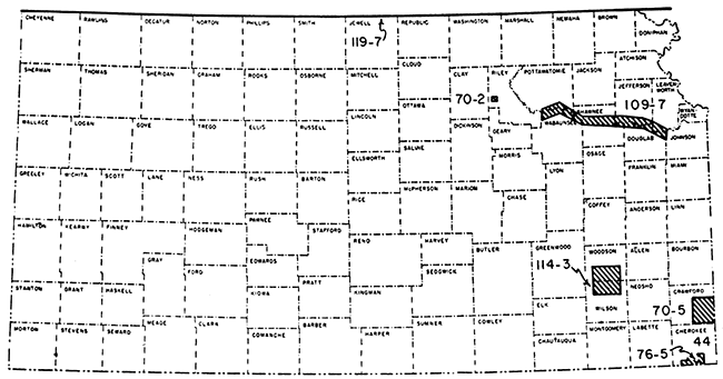
In addition to commercial activity and research by private industry, some research is being conducted by governmental agencies. Most information obtained by private concerns does not find its way into the literature; much of the work of research institutions is published. The U. S. Coast and Geodetic Survey, U. S. Geological Survey, and Bureau of Reclamation have sponsored several projects in Kansas (Deel and Howe, 1948; Duerksen, 1949; Happ, 1946; Jakosky, 1950; Pakiser, Mabey, and Warrick, 1954). Geophysical work also has been conducted by the State Geological Survey of Kansas in areas shown on Figure 1 (Dreyer, 1947, 1947a, 1948; Hambleton and Merriam, 1955; Jakosky, Dreyer, and Wilson, 1942; Merriam, 1954; and Merriam and Hambleton, 1956).
Figure 1--Index map showing areas in which geophysical work has been conducted by State Geological Survey of Kansas (Numbers refer to published Survey Bulletins).
Most of the central and western part of Kansas had been surveyed with magnetometer by 1929. Even at that early date, there had been geophysical activity in all but 29 of the 105 counties in the state (Heiland, 1929). These early studies were concentrated along the Nemaha ridge, other south-trending anticlines, and shoestring oil fields.
Magnetic work was being conducted in the state as late as 1937, but no details are available. As recently as 1942, 75 crew months were reported in the state; since that time there has been little magnetic exploration, except for 5 crew months reported during 1946. Although at present there is no magnetometer crew working in the state, one was reported to have worked a total of 4 crew weeks in extreme eastern and southeastern Kansas in Labette and Cherokee Counties during 1957.
Sporadic use of magnetic exploration for oil and gas in Kansas would indicate that it has not been successful. Likewise, it is doubtful that the airborne magnetometer is playing much of a role in petroleum exploration in Kansas, although information concerning its use is not available.
There has been no electrical (resistivity) exploration in Kansas recently, and essentially negative results were obtained in the 1930's (Karcher and McDermott, 1935).
As early as 1925, pendulum equipment was being used in Kansas for petroleum exploration (Eckhardt, 1949). Seemingly, this was the first commercial use of gravity methods in the state. Early use was made of the torsion balance along the Nemaha ridge and on the Central Kansas Uplift for detailing basement topography (Heiland, 1929), and other work was conducted in south-central and central Kansas. A torsion-balance survey crew was reported working in the state in 1937 and 1938.
In recent years the gravimeter has been used with some success in western Kansas. The total amount of gravity work has declined since 1942, except for an increase from 1948 to 1951 (Fig. 2), a slight increase during 1955, and in 1957 one gravity crew worked more than 50 crew weeks.
Even though gravity methods and instrumentation have improved considerably in the last decade, it is doubtful that the gravimeter will find increased use in petroleum exploration in Kansas, because it is not a high-resolution tool.
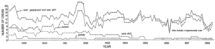
Figure 2--Graph showing number of geophysical and core-drill crews working in Kansas monthly from October 31, 1948, to August 31, 1958 (based on information from I.O.C.C.).
The amount of published material on seismic work in Kansas is small in relation to the amount of seismic exploration. Weatherby (1949, p. 286) reported that an extensive area in central Kansas had been mapped on the "Cimarron anyhydrite" by the spring of 1929. This was soon after the first successful application of seismic methods to oil finding in Oklahoma in the late 1920's. Subsequently, the seismograph has been used extensively in Kansas and has found favor with the oil industry.
Inasmuch as many oil-producing structures in Kansas exhibit very low relief, sources of error in seismic operation and interpretation must be evaluated with care. Thralls and Mossman (1952) demonstrated that arbitrary application of near-surface corrections to seismic data can lead to erroneous results. The problem of lateral variation in seismic velocity due to alteration of shallow Permian salt beds by ground water has been discussed by Widess (1952). Glover (1953) summarized the problems of seismic work in Kansas and suggested methods for minimizing errors, including use of isotime maps. The wisdom of careful attention to sources of error, development of a systematic program, and adoption of improved methods of interpretation is shown in a case history of the Smallwood pool in Stafford County (Beebe and Ballou, 1956).
A seismic reflection quality map of the United States, which designates areas as "good", "fair", or "poor to no good" was published by Lyons in 1951. The map, on a small scale, shows reflection quality in Kansas as "good" to "fair", except in southwestern Kansas, in a narrow belt along the southeast border of the state, and over the northern part of the Nemaha Anticline.
The development of reflection seismograph for use in shallow investigations was reported by Pakiser, Mabey, and Warrick (1954). High-frequency reflection seismograph now makes it possible to map structure on shallow horizons that reflect structure at depth.
The total number of exploration crews in Kansas has increased since 1946 because of the increased number of seismic parties; the number of gravimeter and core-drill crews has decreased. A graph showing the number of crew weeks worked in Kansas from 1937 to 1957 (Fig. 3) shows relation to economic conditions of the country. In pre-World War II days, exploration was slow, but increased rapidly during the war. A postwar slump is evident especially in 1947 and 1949. The Korean conflict brought about renewed exploration activity, mainly seismic. Activity in 1956 declined from the preceding four years, possibly reflecting tight credit and increasing interest in foreign exploration. This decline, however, was reversed in 1957.
A more detailed graph shows the number of seismic, gravity, and core-drill crews in Kansas on a monthly basis from October 1948 through August 1958 (Fig. 2; also see Table 1). Crew activity can be correlated with economic conditions and global politics from this graph also. As this graph is more up-to-date than Figure 3, it shows the early 1958 "recession"; also, it shows return to a normal level of activity later in 1958.
Figure 3--Graph of geophysical and core-drill activity in terms of crew weeks from 1946 to 1957.
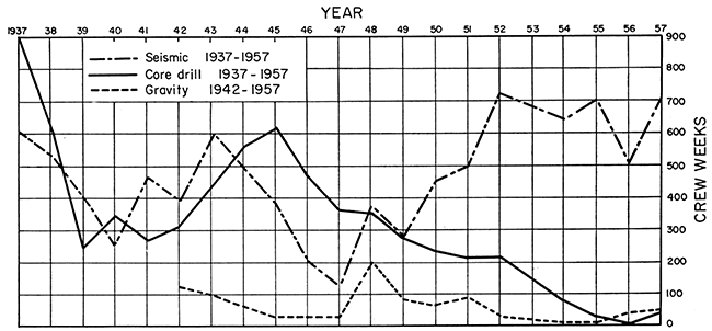
Table 1--Number of crews operating in Kansas.
| Year | Seismic crews |
Gravimeter crews |
Core-drill crews |
Total crews |
Total crew weeks all geophysical |
|---|---|---|---|---|---|
| 1957 | 21 | 1 | 1 | 24* | 797 |
| 1956 | 25 | 1 | 2 | 28 | 547 |
| 1955 | 39 | 1 | 3 | 43 | 740 |
| 1954 | 28 | 1 | 3 | 32 | 729 |
| 1953 | 25 | 1 | 4 | 30 | |
| 1952 | 27 | 1? | 3 | 30 | 967 |
| 1951 | 25 | 1 | 5 | 31 | 792 |
| 1950 | 746 | ||||
| 1949 | 7 | 1 | 4 | 12 | 622 |
| 1948 | 7 | 3 | 9 | 19 | 934 |
| 1947 | 4 | 2 | 5 | 11 | 513 |
| 1946 | 1 | 0 | 7 | 8 | 677 |
| * Includes 1 magnetic crew. | |||||
Seismic exploration has been concentrated mainly in the western part of the state, centering in the areas of the Central Kansas Uplift, Pratt Anticline, Sedgwick Basin, and Hugoton Embayment. Some work also has been reported in the vicinity of the Cambridge Arch, along the Nemaha Anticline, and in the Salina ann. Cherokee Basins. From 19 to 41 percent of the total new oil and gas field discoveries in the state from 1953 to 1957 have been credited to seismic work. If present trends in seismic exploration continue, the subsurface in Kansas will be scrutinized even more closely. Refinement in instrumentation and interpretation, however, probably will have more effect than a high level of crew-month activity.
Only a minor amount of geophysical work is being done in Kansas at present to locate ore deposits, construction material, and ground water.
Metal mining in Kansas is confined to the Tri-State zinc and lead district. Several published papers indicate that magnetic, electrical, and gravity surveys may have value in finding possible new areas for detailed exploration in the Tri-State district. Jakosky, Dreyer, and Wilson (1942) report' that prior to their work, geophysical investigations in the Tri-State area had been either of very short duration or regional rather than detailed in character.
Some work has been done with electrical resistivity equipment in locating construction material and in determination of overburden in connection with highway construction by the Kansas Highway Commission, but little information is available on the results. Also, seismic refraction surveys were found to be of some use at dam sites for the purpose of mapping bedrock (Jakosky, 1950).
The Kansas State Board of Health, Oil Field Section, had some success with electrical resistivity methods in locating areas where fresh ground water was being polluted by brine at shallow depths in central and southeastern Kansas, but this work has been discontinued.
It is not known whether any geophysical method is being used commercially to locate ground-water supplies. Electrical resistivity methods (Merriam, 1954) and shallow seismic methods (Pakiser, Mabey, and Warrick, 1954) seemingly offer the best results in this field.
Beebe, B. W., and Ballou, A. L., Jr. (1956) Case history of the Smallwood pool, Stafford County, Kansas: Geophys. Case Histories, v. 2, p. 310- 327.
Brichta, L. C., and Ryan, J. P. (1958) Practical evaluation of electricalresistivity surveys as a guide to zinc-lead exploratory drilling, Badger-Peacock Camp and vicinity, Cherokee County, Kansas: U.S. Bur. Mines Rpt. Invest. 5426, p. 1-91.
Casey, R. D., and Wantland, Dart (1953) Seismic investigations at the Kirwin Dam site, Solomon unit, Kansas River district, Missouri River Basin Project: U. S. Bur. Reclamation, Eng. Geol. Br. Geology Rept., no. G-124, p. 1-5.
Cook, K. L. (1951) Regional gravity survey in northeastern Oklahoma and southeastern Kansas (abstract): Geophysics, v. 16, no. 3, p. 559-560.
Cook, K. L. (1954) Resistivity survey over slump structures, Tri-State lead-zinc mining district, Cherokee County, Kansas (abstract): Geophysics, v. 19, p. 631.
Cook, K. L. (1955) Magnetic surveys over serpentine masses, Riley County, Kansas: Mining Engineering, v. 7, no. 5., p. 481-488.
Cook, K. L. (1956) Regional gravity survey in northeastern Oklahoma and southeastern Kansas: Geophysics, v. 21, no. 1, p. 88-106.
Cook, K. L., and Van Nostrand, R. G. (1954) Interpretation of resistivity data over filled sinks: Geophysics, v. 19, no. 4, p. 761-790.
Deel, S. A., and Howe, H. H. (1948) United States magnetic tables and magnetic charts for 1945: U. S. Coast and Geodetic Survey, ser. 667, p. 1-135.
Dreyer, R. M. (1947) Magnetic survey of the Bala intrusive, Riley County, Kansas: Kansas Geol. Survey, Bull. 70, pt. 2, p. 21-28. [available online]
Dreyer, R. M. (1947a) Magnetic survey of southeastern Crawford County, Kansas: Kansas Geol. Survey, Bull. 70, pt. 5, p. 105-115. [available online]
Dreyer, R. M. (1948) Radioactivity surveys in the Kansas part of the Tri-State zinc and lead mining district, Cherokee County, Kansas: Kansas Geol. Survey, Bull. 76, pt. 5, p. 113-120.
Duerksen, J. A. (1949) Pendulum gravity data in the United States: U. S. Coast and Geodetic Survey, Spec. Publ. No. 244, p. 1-218.
Eckhardt, E. A. (1949) A brief history of the gravity method of prospecting for oil: Geophysical Case Histories, v. 1, p. 21-32.
Faust, L. Y. (1942) Geophysics in the Mid-Continent: Geophysics, v. 7, no. 3, p. 272-274.
Fisher, R. B. (1953) Transmission characteristics of near surface layers, Barton County, Kansas (abstract): Proc. Geophysical Soc. Tulsa, v. 1, p. 72.
Gaither, V. U. (1956) Index of wells shot for velocity (fourth supplement): Geophysics, v. 21, no. 1, p. 156-178.
Gaither, V. U. (1957) Index of wells shot for velocity (fifth supplement): Geophysics, v. 22, no. 1, p. 120-135.
Gaither, V. U. (1957) Index of wells shot for velocity (sixth supplement): Geophysics, v. 22, no. 5, p. 60-79.
George, P. W. (1929) Experiments with Eotvos torsion balance in the TriState zinc and lead district: A.I.M.E. Geophysical Prospecting Vol., p.561-571.
Glover, R. H. (1953) Seismograph pays off in Kansas: World Oil, v. 137, no. 4, p. 109-110, 112, 114, 116.
Hambleton, W. W., and Merriam, D. F. (1955) Magnetic anomalies in Wilson and Woodson Counties, Kansas: Kansas Geol. Survey, Bull. 114, pt. 3, p.113-I28.
Hambleton, W. W., and Merriam, D. F. (1957) Review of geophysical activity in Kansas through 1956: Kansas Geol. Survey, Bull. 127, pt. 1, p. 1-24.
Happ, S. C. (1946) Electrical resistivity investigations of levee foundations near Kansas City (abstract): Geol. Soc. America, Bull., v. 57, no. 12, pt. 2, p. 1200.
Harbaugh, M. D. (1932) Magnetic map of Tri-State completed: Mining and Metallurgy, v. 13, no. 302, p. 86.
Hartenberger, R. A. (1948) A radioactivity survey over Rose Dome, Woodson County, Kansas: Kansas Geol. Survey, open file, p. 1-7.
Heiland, C. A. (1929) Geophysical methods of prospecting: Colorado Sch. Mines Quart., v. 24, no. 1, p. 38, 68-72.
Jakosky, J. J. (1943) Geophysical investigations in the Tri-State zinc and lead mining district by J. J. Jakosky, R. M. Dreyer, and C. H. Wilson (review): Geophysics, v. 8, no. 2, p. 177-178.
Jakosky, J. J. (1943a) Exploration investigations in Tri-State zinc and lead mining district: Am Assoc. Petroleum Geologists Bull., v. 27, no. I, p. 86-87.
Jakosky, J. J. (1950) Exploration geophysics, second edition: Trija Publ. Co., Los Angeles, Calif., p. 921-925.
Jakosky, J. J., Dreyer, R. M., and Wilson, C. H. (1942) Geophysical investigations in the Tri-State zinc and lead mining district: Kansas Geol. Survey, Bull. 44, p. 1-151. [available online]
Jenny, W. P. (1932) Magnetic vector study of regional and local geologic structure in principal oil states: Am. Assoc. Petroleum Geologists Bull., v. 16, no. 12, p.1177-I203.
Jenny, W. P. (1941) Geological interpretation of regional magnetic anomalies in central and southern United States: Oil Weekly, v. 103, no. 3, p. 17-18, 22.
Jensen, Homer (1949) Airborne magnetic profile above 40th parallel, eastern Colorado to western Indiana: Geophysics, v. 14, no. I, p. 57.
Karcher, J. C., and McDermott, Eugene (1935) Deep electrical prospecting: Am. Assoc. Petroleum Geologists Bull., v. 19, no. 1, p. 64-77.
Logue, L. L. (1954) Gravity anomalies of Texas, Oklahoma, and the United States: The Oil and Gas Jour., v. 52, no. 50, p. 132-135.
Lyons, P. L. (1950) A gravity map of the United States: Tulsa Geological Soc. Digest, v. 18, p. 33-43.
Lyons, P. L. (1951) A seismic reflection quality map of the United States: Geophysics, v. 16, no. 3, p. 506-510.
Merriam, D. F. (1954) Electrical resistivity studies in the Kansas River valley: Kansas Geol. Survey, Bull. 109, pt. 7, p. 97-112. [available online]
Merriam, D. F., and Hambleton, W. W. (1956) Relation of an airborne magnetic profile to the geology along the Kansas-Nebraska border: Kansas Geol. Survey, Bull. 119, pt. 7, p. 251-266. [available online]
Moore, R. W. (1950) Geophysical methods of subsurface exploration applied to the location and evaluation of sand and gravel deposits: Natl. Sand and Gravel Assoc. Circ. 37, p. 1-9.
Moore, R. W. (1952) Geophysical methods of subsurface exploration applied to materials surveys: Highway Research Board Bull. 62, p. 85-107.
Nettleton, L. L. (1943) Transcontinental gravitational and magnetic profile of North America and its relation to structure by G. P. Woollard (review): Geophysics, v. 8, no. 4, p. 419-421.
Pakiser, L. C., and Mabey, D. R. (1954) Mapping shallow horizons with the reflection seismograph: Science, v. 119, no. 3099, p. 740.
Pakiser, L. C., Mabey, D. R., and Warrick, R. E. (1954) Mapping shallow horizons with reflection seismograph: Am. Assoc. Petroleum Geologists Bull., v. 38, no. 11, p. 2382-2394.
Pakiser, L. C., and Warrick, R. E. (1956) A preliminary evaluation of the shallow reflection seismograph: Geophysics, v. 21, no. 2, p. 388-405.
Patton, J. F. (1935) The shoestring oil sands-their geologic occurrence and the possibilities of tracing them with geophysical methods: Mines Magazine, v. 25, no. 12, p.I7-23.
Stearn, N. H. (1932) Practical geomagnetic exploration with the Hotchkiss superdip: A.I.M.E. Geophysical Prospecting Vol., p. 169-199.
Swan, B. G. (1944) Index of wells shot for velocity: Geophysics, v. 9, no. 4, p. 540-559.
Swan, B. G. (1946) Index of wells shot for velocity: Geophysics, v. 11, no. 4, p. 538-546.
Swan, B. G. (1949) Index of wells shot for velocity (second supplement): Geophysics, v. 14, no. 1, p. 58-66.
Swan, B. G. (1951) Index of wells shot for velocity (third supplement): Geophysics, v. 16, no. 1, p. 140-152.
Thralls, H. M., and Mossman, R. W. (1952) Relations of seismic corrections to surface geology: Geophysics, v. 17, no. 2, p. 218-228.
Trott, M. J. (1939) Geophysical prospecting in Kansas: Mines Magazine, v. 29, no. 6, p. 311-312.
U.S. Geological Survey (1947) Aeromagnetic map of part of Tri-State mining district: Geophysical Investi., Prelim. Map No.7, open file, 2 sheets.
Weatherby, B. B. (1948) Early seismic discoveries in Oklahoma: Geophys. Case Histories, v. 1, p. 283-302.
Westby, G. H. (1947) Geophysics in the Mid-Continent-past results and future application (abstract): The Oil and Gas Jour., v. 45, no. 36, p.43.
Widess, M. B. (1952) Salt solution, a seismic velocity problem in western Anadarko Basin, Kansas-Oklahoma-Texas: Geophysics, v. 17, no. 3, p.481-504.
Woollard, G. P. (1943) Transcontinental gravitational and magnetic profile of North America and its relation to geologic structure: Geol. Soc. America Bull., v. 54, p. 747-790.
Woollard, G. P. (1948) Recent regional gravity surveys: Am. Geophys. Union Trans., v. 29, no. 5, p. 727-738.
Kansas Geological Survey
Comments to webadmin@kgs.ku.edu
Web version Dec. 10, 2013. Original publication date 1959.
URL=http://www.kgs.ku.edu/Publications/Bulletins/137/Merriam/index.html