![]()
Prev Page--Contents || Next Page--Ground Water Geology
Introduction
Purpose and Scope of the Investigation
Large supplies of ground water are available in the Arkansas River valley between Garden City and Cimarron, Kansas. The United States Bureau of Reclamation is considering the diversion of ground water in the valley to an area northeast of Ingalls for irrigation, A preliminary study by that Bureau of what is referred to as the Ingalls irrigation project indicated that 86,000 acre-feet of ground water might be diverted from the valley to irrigate 58,000 acres in the upland. The project plan proposes pumping from wells penetrating both the alluvium of Arkansas River and the underlying Ogallala formation. Surface How of Arkansas River would be captured by infiltration, replacing water pumped from storage within the aquifer.
Since 1937 a co-operative program to determine the availability and occurrence of ground water in Kansas has been carried on by the United States Geological Survey, the State Geological Survey, the Division of Water Resources of the State Board of Agriculture, and the Division of Sanitation of the State Board of Health. In 1955 the Bureau of Reclamation proposed that an investigation of the availability of ground water in the Arkansas Valley in the Ingalls area be made by the co-operating agencies in Kansas, and in January 1956 such an investigation was started. The results of that study are given in this report.
Objectives of the investigation included an inventory of water used for irrigation and information on depth to water, the character, thickness, and storage capacity of water-bearing materials, yields of wells, possible recharge to the alluvium from Arkansas River, recharge to the Ogallala formation from the overlying alluvium, and the quality of the ground water.
Location and Extent of the Area
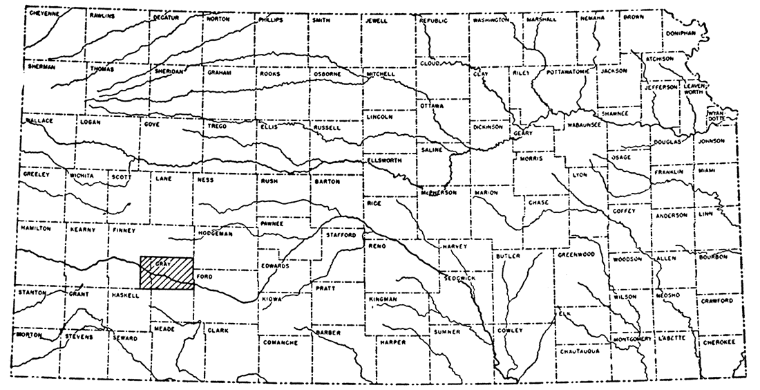
The area of this investigation includes the Arkansas Valley from a point 5 miles west of Pierceville, in Finney County, to a point 7 miles east of Cimarron, in Gray County, and the adjacent upland (Fig. 1). This area, termed the Ingalls area in this report, comprises approximately 540 square miles (Pl. 1).
Figure 1—Index map showing area described in this report.
Previous Investigations
Several studies have been made that deal with the geology and ground-water resources of southwestern Kansas. The principal studies previously made are given below in chronological order.
Nettleton (1892, p. 26, app. 10) reported on the results of some underflow surveys in the Platte and Arkansas River valleys and included a discussion of the water-table configuration at Garden City. Haworth (1897) described the geology and physiography of western Kansas and included a discussion of Arkansas River. That same year he (1897 a) described the results of an investigation of the underground waters of southwestern Kansas, which included the Ingalls area. A report of the Board of Irrigation Survey and Experiment to the Legislature of Kansas for the years 1895 and 1896 contained the log and water-supply data for a state-financed test well in Gray County (Sutton, 1897, p. 18). In the same report, Haworth (1897b) gave a general account of the geology of underground water in western Kansas. In 1902, Slichter (p. 68) included a hydrograph of the city well at Garden City, in a report on the motions of underground waters. Darton (1905, p. 297, 300) reported on the geology and ground-water resources of the central Great Plains and gave a general description of the water supply of Gray County, which includes most of the Ingalls area. Slichter made an intensive investigation of the underflow of Arkansas River in Finney and Kearny Counties, and reported (1906) on the velocity and origin of the underflow, fluctuations of the ground-water levels and quality of the water. He also made pumping tests on several pumping plants in the valley to determine the specific capacity of the wells and the cost of pumping. The quality and availability of water in Finney and Gray Counties were studied by Parker (1911, p. 87-90, 99, 100). Haworth (1913) described the well waters in Kansas and included in his report a brief description of Arkansas River. Theis, Burleigh, and Waite (1935) described briefly the water-bearing formations and the availability of ground water in the entire southern High Plains. Smith (1937) contributed a preliminary paper on Pleistocene gravels in southwestern Kansas in which he described gravel terraces along the Arkansas Valley, and in 1940 he described the Tertiary and Quaternary geology of southwestern Kansas, including the Ingalls area. A report of the U. S. Geological Survey published in 1940 (Water-Supply Paper 886) contained a chapter on the observation-well program in Gray County. Additional reports of this series have been published annually since that time. A report by Latta (1944) included a description of the areal geology, physiography, ground-water supply, and logs of many wells and test holes drilled in Finney and Gray counties, which include the Ingalls area.
Methods of Investigation
The investigation on which this report is based was begun in January 1956 and was completed in August 1956. An inventory was made of 75 irrigation plants in the Ingalls area. Total depth and static water level were measured with a steel tape from a fixed measuring point at the top of each well, and an estimate of well production was obtained from the owner. Additional information was obtained on the depths of and static water levels in 3 public-supply wells and 26 stock and domestic wells.
Drill cuttings were collected, at 5-foot intervals or at each formation change, from 32 test holes drilled by the Bureau of Reclamation using a portable hydraulic rotary drilling rig, and from 2 test wells drilled by a contractor for that bureau. These samples were examined and logged in the field and later studied with a binocular microscope in the laboratory; lithologic logs were then prepared. Additional information was obtained from 76 augered test holes, 35 to determine the thickness and lithology of the alluvium of Arkansas River and 41 to obtain measurements of the water level. Local well-drilling contractors supplied 13 drillers logs of wells and test holes in the area. Information was obtained from sample logs of 7 test holes drilled during the field investigation of Finney and Gray Counties (Latta, 1944). Using a spirit level, a topographic mapping crew of the Bureau of Reclamation determined the altitudes of measuring points of all wells and the land-surface altitude of all test holes.
Twelve samples of water were collected from representative wells in the area and two samples from Arkansas River. These samples were analyzed in the Water and Sewage Laboratory of the State Board of Health.
Aquifer tests were conducted in seven wells. Three of these tests made use of existing irrigation wells, of which two were in the Ogallala formation north of Arkansas River valley and one in the alluvium of Arkansas River. Four aquifer tests made use of wells drilled by private contractors for this investigation. Two of these wells were in the alluvium of Arkansas River and two were in the underlying Ogallala formation.
Field data were compiled on modified base maps prepared by the Bureau of Reclamation. Aerial photographs were used to determine locations of test holes where other methods were not accurate.
Well-numbering System
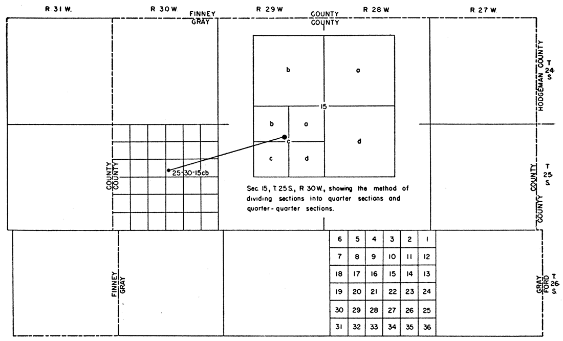
The well and test-hole numbers used in this report give the location of wells and test holes according to General Land Office surveys and according to the following formula: township, range, section, 160-acre tract within that section, and 40-acre tract within that quarter section. The l60-acre and 40-acre tracts are designated a, b, c, and d in a counterclockwise direction beginning in the northeast quarter. If several wells or test holes are in a 40-acre tract, they are numbered serially in the order in which they were inventoried. For example, well 25-30-15cb1 is the first well inventoried in the NW SW~ sec. 15, T. 25 S., R. 30 W. (Fig. 2).
Figure 2—Map of Ingalls area illustrating well-numbering system used in this report.
Acknowledgments
The writers acknowledge the help of residents of the area who gave information regarding their wells, who permitted test drilling on their land, and those who permitted the use of their land and irrigation wells for aquifer tests. Appreciation is expressed to B. F. Powell, Area Planning Engineer, and his staff of the Bureau of Reclamation for assistance in planning the field investigation and in collecting basic data. Special recognition is given to Woodrow Hayes and Oscar Parker of the Bureau of Reclamation field office at Cimarron, and to Victor Pineo, John Simons, John Leathers, and Henry Blake of the Bureau's drill crew. Acknowledgment is given Orville Harold of the Soil Conservation Service and Milton N. Thomas, Gray County Agent, both from Cimarron. Records and information were obtained through the courtesy and co-operation of the following drilling companies: Gestenslager Drilling Co., Henkle and Co., Minter Drilling Co., and Western Drilling Co., all of Garden City.
The manuscript of this report has been reviewed by several members of the Bureau of Reclamation and of the Federal and State Geological Surveys; by Dwight Metzler, Director and Chief Engineer, and W. O. Hilton, Geologist, Division of Sanitation, State Board of Health; by R. V. Smrha, Chief Engineer, and George S. Knapp, Engineer, Division of Water Resources, State Board of Agriculture; and by Robert L. Smith, Executive Secretary, and W. E. Steps, Engineer, Water Resources Board.
Climate
The climate of the Ingalls area is characterized by abundant sunshine, moderately low precipitation, low relative humidity, good wind movement, and a high rate of evaporation. Although summer days are hot, the heat is moderated somewhat by good wind movement and relatively low humidity. The winters are moderate, having only occasional, short periods of severe cold. The amount of precipitation and its seasonal distribution are the chief factors controlling crop growth.
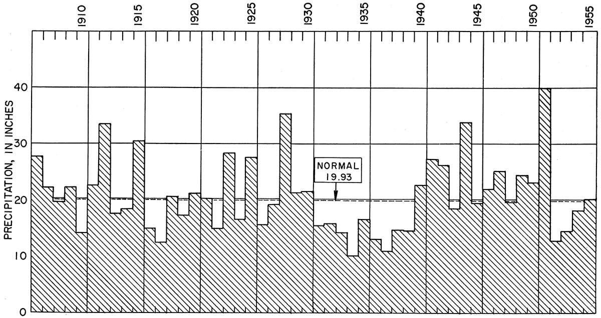
According to records of the U. S. Weather Bureau, the normal annual precipitation at Cimarron is 19.93 inches, nearly 75 percent of which falls from April through September. The normal monthly precipitation is shown in Figure 3. The annual precipitation for the years of record, 1906-55, has ranged from 10.08 inches in 1934 to 39.98 inches in 1951 (Fig. 4.)
Figure 3—Normal monthly precipitation at Cimarron.
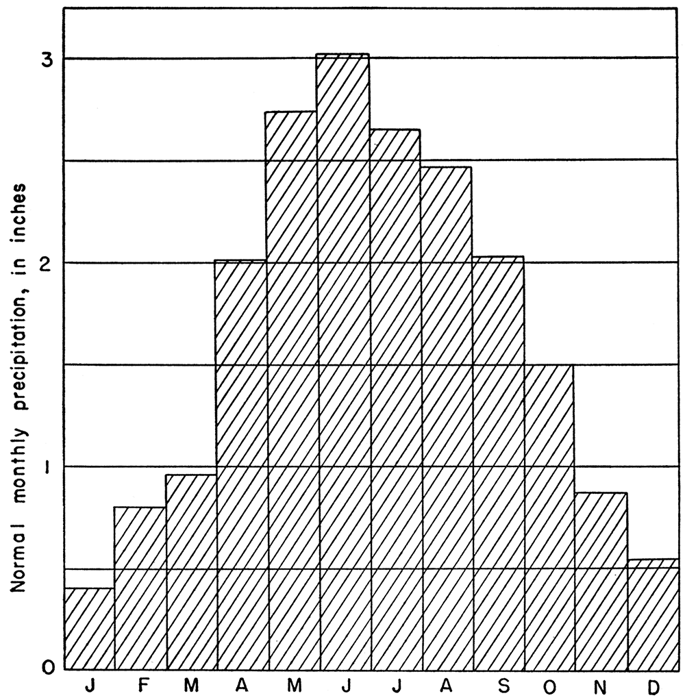
Figure 4—Annual precipitation at Cimarron, 1906-55.
The mean annual temperature for the area is 55°F. July is the hottest month, having a mean temperature of 79.3°, and January is the coldest, having a mean temperature of 31.0°.
The average length of the growing season is 175 days. The longest growing season on record was 198 days, and the shortest was 154 days. The average date of the last killing frost in the spring is April 24, and that of the first killing frost in the fall is October 16. The latest recorded date of a killing frost in the spring was May 27, 1907, and the earliest in the fall was September 25, 1912.
General Geology
Geomorphology
The Ingalls area presents several striking topographic contrasts. North of Arkansas River the valley is bordered by a continuous line of bluffs approximately 100 feet above the floodplain, which are extensively notched by deep, short draws. The upland north of the bluffs is part of the High Plains physiographic province (Schoewe, 1949) and is a relatively flat treeless plain sloping eastward about 7 or 8 feet per mile. Locally, the plain is marked by undrained depressions ranging in diameter from a few feet to about a mile.
The area south of the bluffs is in the Finney Lowland physiographic subdivision (Schoewe, 1949). This subdivision includes the floodplain of Arkansas River and the gently sloping outer valley, which is extensively mantled by dune sand and lies below the High Plains surface. Arkansas River has an eastward gradient of about 7 feet per mile. Its flood channel is 300 to 400 feet wide, but during most of the year the flow of the river is small and is confined to a narrow channel 50 to 75 feet wide.
At least two terraces flank the Arkansas River valley in this area. The lower terrace is 4 to 6 feet above the floodplain and is most noticeable north of the river. The upper terrace is 20 to 25 feet above the floodplain and is continuous along the south side of the valley. Its width is not known because it is covered by dune sand except along the scarp. Scattered terrace remnants that are probably equivalent to the upper terrace occur along the north side of the valley, notably west of Ingalls where a small draw has cut through the deposits.
The area south of the Arkansas Valley has a typical dune topography—moderate slopes and hills separated by small basins. Sand dunes extend southward a maximum of 11 miles from Ingalls and are the eastern extension of the Finney sand plain described by Smith (1940, p. 140-145, fig. 19). Most of the dunes are covered by vegetation and protected from wind action. A few are marked by blowouts, generally caused by trampling of livestock near watering and feeding places. There is no surface drainage from the sand dunes, and all precipitation accumulates in depressions until it either evaporates or seeps into the ground.
Summary of Stratigraphy
[Note: The classification and nomenclature of the rocks described in this report follow those of the State Geological Survey of Kansas. They differ somewhat from those used in formal reports of the U. S. Geological Survey.]
The rocks that crop out in the Ingalls area are sedimentary and range in age from Tertiary to Recent. These rocks are underlain by shale of Cretaceous age believed to be the Carlile shale (Fig. 5). A generalized section of the geologic formations and their water-bearing properties is given in Table 1.
Figure 5—Configuration of surface of Cretaceous shale in Ingalls area.
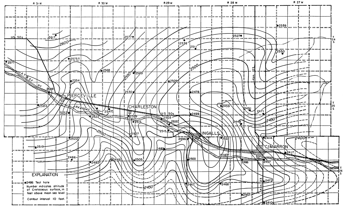
Table 1—Generalized section of geologic formations and their water-bearing properties
| System | Series | Group | Stage | Formation | Thickness (feet) |
Character | Water supply |
|---|---|---|---|---|---|---|---|
| Quaternary | Pleistocene | Recent | Alluvium | 0-40 | Silt, sand, and gravel underlying flood plain. | Yields large supplies of water supplies most domestic, stock, and irrigation wells in Arkansas Valley. | |
| Dune sand | 0-35 | Fine to coarse wind-deposited sand; contains some silt. | Lies above the water table and yields no water to wells. Serves as intake area for ground-water recharge. | ||||
| Sanborn | Wisconsinan | ||||||
| Terrace deposits | 0-25± | Silt, sand, and gravel, poorly sorted. Extensively quarried for road metal and aggregate. | Generally lies above water table but locally supplies some stock wells and water for one irrigation system. | ||||
| Illinoian (?) | Undifferentiated sands and silts | 0-65 | Silt and fine to coarse sand. Underlies dunes south of Arkansas River. | Lies above water table and sand yields no water to wells. | |||
| Meade | Late Kansan (?) | 0-150± | Predominantly sand and gravel; contains some silt. Underlies younger Pleistocene deposits in sand-dune area. | Almost undeveloped but capable of yielding large supplies of water to wells. | |||
| Tertiary | Pliocene | Ogallala | 75-300± | Calcareous silt, sand, and gravel. Underlies entire area. | Yields moderate to large supplies of water; supplies all domestic, stock, and irrigation wells north of Arkansas River Valley. | ||
| Cretaceous | Gulfian | Colorado | Carlile shale | 250-300± | Dark-gray calcareous shale. | Not known to yield water to wells in this area. |
The oldest rock formation that crops out in the Ingalls area is the Ogallala formation (Pliocene). It is present throughout the area, but in most places is mantled by younger deposits. South of Arkansas River the Ogallala formation is overlain by a thick deposit of silt, sand, and gravel, probably of late Kansan age. Overlying the thick sand and gravel south of the Arkansas Valley and overlying the Ogallala formation north of the Arkansas Valley is a sequence of water-laid sands and silts that grade upward into eolian silts and are assigned to the Sanborn group. The upper terrace south of the Arkansas Valley is probably of late Wisconsinan age and is included in the Sanborn group. Overlying the Sanborn group south of the Arkansas Valley is an extensive deposit of dune sand, which is probably of Recent age, although the dunes, in part, may be contemporaneous with the upper terrace. The alluvium and lower terrace of Arkansas River are of Recent age.
In the geologic cross sections (Pl. 2, 3) all unconsolidated deposits except the alluvium are classed as Pliocene and Pleistocene undifferentiated. No attempt was made to subdivide the Ogallala formation and the Pleistocene deposits, owing to lack of any positive evidence other than lithologic differences, although the deposits differ enough lithologically to warrant separate descriptions in the section that follows.
Prev Page--Contents || Next Page--Ground Water Geology
Kansas Geological Survey, Geology
Placed on web Sept. 10, 2017; originally published July, 1958.
Comments to webadmin@kgs.ku.edu
The URL for this page is http://www.kgs.ku.edu/Publications/Bulletins/132/02_intro.html