Kansas Geological Survey, Bulletin 130, part 5, originally published in 1971
Originally published in 1958 as Kansas Geological Survey Bulletin 130, part 5. This is, in general, the original text as published. The information has not been updated.
Five structural maps on top of the Dakota Formation (Cretaceous) in Kansas published in 1905, 1918, 1926, 1954, and 1957 are presented. Each successive map incorporated new information, thus in essence the maps are progress reports over a span of 53 years showing changing concepts of structure in central and western Kansas.
Publication of a revised regional structural contour map on top of the Dakota Formation (Cretaceous) in central and western Kansas suggests comparison with similar maps published previously over a span of 53 years. Five structural maps contoured on top of the Dakota Formation in Kansas have been published and are reproduced here: Darton (1905, 1918), Bass (1926), Lee and Merriam (1954), and Merriam (1957).
The structure maps have been reduced to a common base for ease in visual comparison. At a glance they show the changing concept through the years of interpretation of structure on top of the Dakota Formation in Kansas. Interpretation has changed as an increased number of wells penetrating the subsurface in the search for petroleum and ground water has steadily increased control.
The name Dakota was applied by Meek and Hayden in 1862 to a series of beds that crop out in the bluffs along Missouri River in Dakota County, Nebraska. Subsequently these beds were traced southward into Kansas. The Dakota Formation in Kansas, assigned to the Gulfian Series (Upper Cretaceous), is overlain by Graneros Shale and underlain by Kiowa Shale. The formation crops out extensively in north-central Kansas from Washington County southwestward to Rice County, where it is covered by Tertiary and Quaternary deposits; other small areas of outcrops occur west of Rice County. On the outcrop the formation is divided into two members, but in the subsurface in western Kansas and eastern Colorado three members are recognized. In northwestern Kansas the formation lies as deep as 2,200 feet below the surface and commonly is about 300 feet thick. On the surface in north-central Kansas the Dakota Formation is chiefly nonmarine and contains plant fossils and land vertebrates, but farther west, in the subsurface, seemingly it is mostly marine as shown by fossil and mineralogical content. Where marine, the formation consists mostly of alternating sandstone and shale. The Graneros-Dakota contact (upper limit of the Dakota Formation), which is easily recognized on electric and radioactivity logs and in well samples, is a usable horizon for structural mapping. As Mesozoic deposits are absent in the eastern part of the state, little information is available for interpretation of Mesozoic structural provinces there.
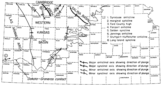
Geographic locations of axes of Mesozoic structures in central and western Kansas are shown in Figure 1. With few exceptions, these Mesozoic structures do not coincide with earlier structures that formed during the Paleozoic Era. Four major structural elements--the east flank of the Las Animas Arch, southern end of the Cambridge Arch, Western Kansas Basin, and western side of the Salina Basin-are indicated, along with some prominent minor structures. Most structures trend either northeast or northwest. Regional dip of Mesozoic beds is northerly in Kansas except in the vicinity of the Cambridge Arch where it is southerly.
Some additional references on the Dakota Formation and the structure of western Kansas are Jewett (1951), Merriam (1955, 1957a), Moore and others (1951, 1952), Plummer and Romary (1942), Tester (1931), and Twenhofel (1924).
Figure 1--Index map showing location of major and some minor Mesozoic structures in central and western Kansas.
In 1905 Darton published a preliminary map (dated 1904) showing the structure on the Dakota sandstone. The map was prepared in connection with ground-water studies of the central Great Plains covering parts of Montana, Wyoming, South Dakota, Nebraska, Colorado, Kansas, Minnesota, and Iowa. Data were obtained principally from shallow borings drilled in search of underground water. From a list of wells that Darton believed to be nearly complete, about 30 wells in central and western Kansas yielded information usable for the structural map. Some surface elevations probably were obtained from topographic maps in the outcrop area of Dakota-Lakota sandstones, although number and distribution of control points are not shown on the map or mentioned specifically in the text. The Kansas portion of Darton's map of the central Great Plains is reproduced as Figure 2.
Figure 2--Darton's 1905 structural contour map on Dakota-Lakota sandstones in central and western Kansas.
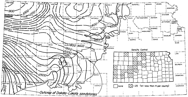
In the area of Dakota-Lakota outcrop, the formations are beveled, hence contours there do not represent structure on top of the Dakota. Considering the control Darton had at his disposal, the map is accurate in portraying regional structure in western Kansas.
The structurally lowest part of the Salina Basin is outlined by the 1,100-foot contour in northwestern Smith County. Darton shows the axis of the basin to trend slightly northeast. The eastern flank of the Salina Basin in pre-Mesozoic beds is limited by the northeast-trending Nemaha Anticline, which extends across Kansas from Nemaha County to Sumner County. If Cretaceous beds now extended far enough east to cover the Nemaha Anticline, they probably would reflect the anticline.
The western side of the Salina Basin is flanked by the Cambridge Arch, sometimes referred to as Darton's arch. In 1905 Darton showed the position of this major structural feature in western Norton County, eastern Decatur County, western Graham County, and eastern Sheridan County. On the basis of his scanty data, Darton indicated that the arch had a northeast trend, and plunged northeastward toward Nebraska.
Another large structural feature is shown trending approximately northeast in Ford and Hodgeman counties. West of this high the contours vaguely outline a synclinal area trending through southern Lane County, eastern Finney County, and Gray County. West of this synclinal area is an extensive homoclinal structure, which is in essence the eastern flank of the Las Animas Arch, the axis of which is located farther west in eastern Colorado.
A slightly revised structural contour map on top of the Dakota sandstone for the central Great Plains region was issued by Darton in 1918 (Fig. 3). The map covers about the same area as the one published in 1905. The only obvious difference from the map previously published is the delineation of a small "high" in southern Hamilton County. The high was outlined by Darton (1920) while making detailed studies in the Syracuse and Lakin quadrangles.
Figure 3--Darton's 1918 structural contour map on Dakota sandstone in central and western Kansas.
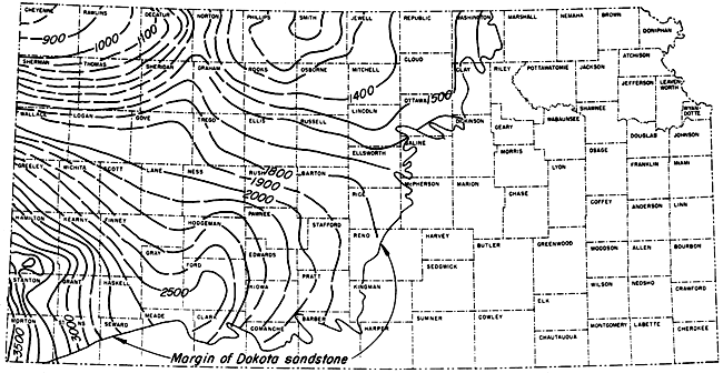
Darton (1918) makes the following statement concerning the Kansas portion of his structural map: "The Cretaceous rocks dip in various directions, sloping into a wide, shallow syncline whose center is in the western part of Smith County and rising into a low dome whose axis passes near Dodge and Jetmore." The syncline located in Smith County is, of course, the Salina Basin. The unnamed high in Ford and Hodgeman counties, the axis of which passes near Dodge and Jetmore, trends northeast and plunges northeast. Darton further states that: "The Cretaceous strata in southwestern Kansas rise on the slope of a gentle dome that culminates in southeastern Colorado", indicating that at that time he recognized the "high" in eastern Colorado now known as the Las Animas Arch.
Darton's recognition of an anticlinal feature in southern Hamilton County was later substantiated by detailed work elaborated on by Bass (1926), Smith (1940), and McLaughlin (1943); this structure is now known as the Syracuse Anticline. According to Darton: ". . . the scattered outcrops and well records indicate doming of considerable steepness. . . . The Dakota sandstone crops out on the southeast slope of the dome and is reached by wells at other places, so that its position is indicated by ample data." Primarily on the basis of physiographic evidence, Smith (1940) recognized the possibility of a fault on the southern side of the structure. The fault was later found by test drilling (McLaughlin, 1943, p. 124).
In discussing northwestern Kansas, Darton says: ". . . Doubtless there are many local variations in the dip and rate of dip, but they are difficult to detect in the shales, especially as in wide areas these rocks are covered by the Tertiary deposits. . . ." From this statement it is evident that Darton realized that many minor structures were present, which could not be depicted with the amount of data he had at that time.
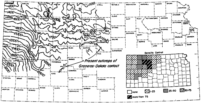
In 1926 Bass published a structural map on top of the Dakota Formation in western Kansas using more than 500 control points (Fig. 4). Data for this map were obtained late in 1924, and consisted of well data and outcrop elevations. Enough wells had been drilled to show somewhat more structural detail, especially in Osborne, Rooks, Ellis, and Russell counties. Drilling in these counties followed discovery of the Fairport oil pool in 1923, which had been found by drilling on a surface anticline in Cretaceous rocks. The new reserves discovered in the Fairport field, being a great distance from other oil areas, served as an incentive to drilling in western Kansas areas.
Figure 4--Bass's 1926 structural contour map on Dakota sandstone in central and western Kansas.
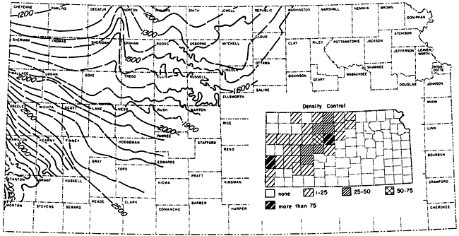
Bass made the following observation in regard to his map: "The most pronounced feature shown in Kansas on the structure map, as well as on Darton's maps of 1905 and 1918, is the Cambridge anticline, more generally known as Darton's arch, the axis of which trends northward through the eastern edge of Decatur county into Nebraska. The structure contours in Decatur county and western Norton and Graham counties are based on a number of control points, but the southern extension of the nose of the anticline through southern Sheridan and Gove counties is largely conjectural. . . ."
Bass describes the following minor structures: "A rather pronounced and extensive series of structural 'highs' extends from northwestern Ellis county north-northeastward across Rooks county, passing a few miles west of Stockton and thence into Phillips county near Phillipsburg. It is possible that the nose crossing the southeast corner of Trego county is the southward continuation of the Stockton fold or one en echelon with it. . . . The Fairport-Natoma anticline, which is most prominent near the Russell oil field, extends north-northeastward from eastern Rush county into northern Osborne county."
The structural high shown by Darton in Ford and Hodgeman counties is not recognizable on Bass's map, but the Syracuse Anticline in southern Hamilton County is shown much as presented by Darton.
Next, 28 years after Bass's publication, Lee and Merriam (1954) prepared another structural contour map on top of the Dakota Formation in central and western Kansas (Fig. 5), including new information. Configuration of the contours is based on approximately 800 control points all obtained from well-log data. The map is incomplete in that it did not extend contours to the Dakota outcrop. In comparison with the three preceding maps, one major change can be noted on this one in the area of Decatur, Norton, Phillips, Sheridan, Graham, and Rooks counties. From 1926 to 1954 numerous wells were drilled in this region, making available additional data with which it was possible to depict the structure in more detail.
Figure 5--Lee and Merriam's 1954 structural contour map on Dakota Formation in central and western Kansas.
The Cambridge Arch is the large prominent anticlinal feature shown in Norton and Decatur counties; only the southeastern end of this large structure is present in Kansas. The anticline is separated from the area of the former Central Kansas Uplift by small synclinal basins. The southeast plunge of the Cambridge Arch is the only exception to the regional northerly dip on top of the Dakota Formation in Kansas.
Little difference is noted in configuration of the contours on the eastern flank of the Las Animas Arch from the previous maps except (Lee and Merriam, 1954, p. 11): "The northeasterly slope of the Dakota on the flank of the Las Animas Arch is terminated by a well-developed syncline that follows the margin of the arch and will be referred to as the marginal syncline. The syncline trends north from central Finney County to Thomas County but its extension into Cheyenne County to the northwest is without adequate control."
East of the marginal syncline is an area termed the Western Kansas Basin by Lee and Merriam. According to them: "The Western Kansas basin is a minor feature of Dakota structure. . . . East of the Las Animas arch the Dakota surface dips regularly north in a series of northerly plunging anticlines and synclines that extend across the area of the former Central Kansas uplift." Within the area of the Western Kansas Basin are several prominent northerly plunging anticlines and synclines roughly paralleling the marginal syncline of the Las Animas Arch. One of the more prominent of these may be traced from Finney County to Rawlins County, but north of Gove County data for the position of this structure are scanty.
A revised edition of the structural contour map on top of the Dakota Formation was published by Merriam in 1957 (Fig. 6). The map incorporates additional data and has more than 1,500 control points. The information was obtained from electric and radioactivity logs, logs of the Kansas Sample Log Service, sample logs, ground-water test logs, drillers logs and scout tops, and surface elevations in the area of outcrop. This map is very similar to the preceding one (Lee and Merriam, 1954) except that many smaller structures have been revealed by the additional information, and contours have been extended farther east and south.
Figure 6--Merriam's 1957 structural contour map on Dakota Formation in central and western Kansas.
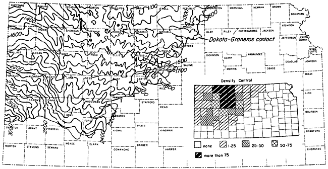
As most of the structures have been discussed in consideration of the previous maps, little is necessary in the way of explanation. As shown by the density-control index map, there are many counties without adequate control for structural contouring even on a regional basis. This is especially evident in north-central Kansas near the eastern edge of Dakota outcrops and in the western part of the state bordering the Colorado line.
Bass, N. W. (1926) Geologic structure of the Dakota sandstone of western Kansas: Kansas Geol. Survey, Bull. 11, pt. 3, p. 84-89. [available online]
Darton, N. H. (1905) Preliminary report on the geology and underground water resources of the central Great Plains: U. S. Geol. Survey, Prof. Paper 32, p. 1-433. [available online]
Darton, N. H. (1918) The structure of parts of the central Great Plains: U. S. Geol. Survey, Bull. 691-A, p. 1-26. [available online]
Darton, N. H. (1920) Syracuse and Lakin Quadrangles, Kansas: U. S. Geol. Survey, Geologic Atlas 212, p. 1-10. [available online]
Jewett, J. M. (1951) Geologic structures in Kansas: Kansas Geol. Survey, Bull. 90, pt. 6, p. 105-172. [available online]
Lee, Wallace, and Merriam, D. F. (1954) Preliminary study of the structure of western Kansas: Kansas Geol. Survey, Oil and Gas Invest. 11, p. 1-23. [available online]
McLaughlin, T. G. (1943) Geology and ground-water resources of Hamilton and Kearny counties, Kansas: Kansas Geol. Survey, Bull. 49, p. 1-220. [available online]
Meek, F. B., and Hayden, F. V. (1862) Descriptions of new Lower Silurian (Primordial), Jurassic, Cretaceous, and Tertiary fossils, collected in Nebraska: Philadelphia Acad. Nat. Sci., Proc., v. 13, p. 415-447.
Merriam, D. F. (1955) Structural development of the Hugoton embayment: Oklahoma Univ., Proc. 4th Subsurface Geol. Symposium, Norman, p. 81-97.
Merriam, D. F. (1957) Preliminary regional structural contour map on top of the Dakota Formation (Cretaceous) in Kansas: Kansas Geol. Survey, Oil and Gas Invest. 15, map. [available online]
Merriam, D. F. (1957a) Subsurface correlation and stratigraphic relation of rocks of Mesozoic age in Kansas: Kansas Geol. Survey, Oil and Gas Invest. 14, p. 1-25. [available online]
Moore, R. C., and others (1951) The Kansas rock column: Kansas Geol. Survey, Bull. 89, p. 1-132. [available online]
Moore, R. C., and others (1952) Graphic column of Kansas rocks: Kansas Geol. Survey, chart.
Plummer, Norman, and Romary, J. F. (1942) Stratigraphy of the pre-Greenhorn Cretaceous beds of Kansas: Kansas Geol. Survey, Bull. 41, pt. 9, p. 313-348. [available online]
Smith, H. T. U. (1940) Geologic studies in southwestern Kansas: Kansas Geol. Survey, Bull. 34, p. 1-244. [available online]
Tester, A. C. (1931) The Dakota stage of the type locality: Iowa Geol. Survey, v. 35, p. 195-332.
Twenhofel, W. H. (1924) The geology and invertebrate paleontology of the Comanchean and "Dakota" formations of Kansas: Kansas Geol. Survey, Bull. 9, p. 1-135. [available online]
Kansas Geological Survey, History of Cretaceous Structural Studies in Kansas
Placed on web Feb. 18, 2009; originally published in Nov. 1958.
Comments to webadmin@kgs.ku.edu
The URL for this page is http://www.kgs.ku.edu/Publications/Bulletins/130_5/index.html