Kansas Geological Survey, Bulletin 127, part 3, originally published in 1957
Originally published in 1957 as Kansas Geological Survey Bulletin 127, part 3. This is, in general, the original text as published. The information has not been updated. An Acrobat PDF version of this report is available (12 MB). Plate 1 available separately.
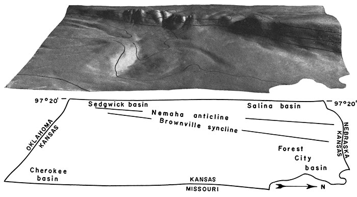
Frontispiece--Surface configuration of Precambrian rocks in eastern Kansas. Model (above) shows surface configuration of buried Precambrian rocks in eastern one-third of Kansas as viewed obliquely from east (north is to right). Named structural features are shown on outline (below). Form lines at 1,000-foot intervals correspond approximately to alternate 500-foot contours on map (Plate 1A). (Model in Lindley Hall, University of Kansas, Lawrence, Kansas.)
Precambrian rocks are not exposed in Kansas, but information concerning them has been assembled from subsurface records. More than 1,600 test wells for oil have been drilled through the cover of younger formations to the Precambrian "basement complex", in which the oldest rocks belong to a metamorphic group. This group has been intruded by a suite of igneous rocks.
The metamorphic group consists mainly of quartzite, granulite, schist, phyllite, and gneiss. Impure marble has been reported in two places. Some of the gneiss is metasedimentary, and some is foliated "earlier" granite, injected about the time of regional metamorphism. The intrusive suite is composed mostly of Precambrian "later" granite, but a few wells near the center of the state encounter gabbro and syenite, probably also Precambrian in age. Widely scattered minor intrusives include diabase and pegmatite.
Precambrian rocks have been affected by major movements in at least four Paleozoic and later periods. Principally in central and eastern Kansas, anticlinal structures have resulted from recurrent uplift. The uplifted areas and the intervening basins are buried at considerable depths beneath Paleozoic rocks. Both the Precambrian surface and all overlying rocks in existence at the time when movement took place show the effect of that movement. Structures in post-Precambrian strata are controlled by irregularities of the uplifted Precambrian surface only locally, however, where this surface was temporarily exposed and eroded. Some degree of differential compaction of the post-Precambrian strata took place around buried Precambrian hills.
Residual deposits and arkosic detritus on weathered parts of the Precambrian surface are reviewed because of their importance in marking the contact of the Precambrian basement complex with overlying Paleozoic rocks. Wherever possible, the average type of basement rocks has been described, and an example of each lithologic group is illustrated in a photomicrograph.
The general arrangement of the Precambrian rocks is shown on a contoured map and in a block diagram.
Plate 2--Quartzite, in thin section (all x19, crossed nicols). A. Quartzite, containing large and small flakes of muscovite, many of which are aligned. Smaller flakes of muscovite are enclosed within quartz grains, an indication that quartz may have recrystallized after muscovite developed. The quartz shows some strain shadows and lines of cavities. Section oblique to the foliation. Ellsworth County (7-17S-10W). B. Quartzite, comparable with A, but having smoother grain boundaries. Principally quartz recrystallized around muscovite, the latter in subparallel arrangement. Section parallel to foliation. Ellsworth County (7-17S-10W). C. Quartzite, small amounts of muscovite mica restricted to definite schistose layers, which are slightly curved, as emphasized by dislocation in center. Almost all quartz grains show undulatory extinction; several small faults break through the grains, not around them. Most fractures are clean cut, but edges of some grains are abraded. Russell County (26-15S-13W). D. Quartzite, minor amounts of muscovite in small flakes included in recrystallized quartz. Parts of section display considerable fragmentation (cataclasis), resulting from dynamic element of metamorphism. Fractures made during preparation of slide show that in all directions quartz breaks across rather than at edge of grain. Barton County (30-16S-11W).
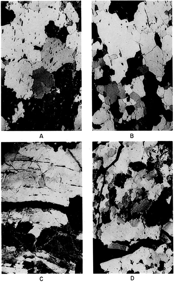
Plate 3--Schist and related rocks, in thin section and cores (all sections x19, crossed nicols). A. Schistose granulite, fragments of quartz unevenly distributed in certain bands. Barton County (24-16S-12W). B. Quartz-mica schist. Quartz in angular grains, mica in small oriented flakes. Barton County (20-16S-11W). C. Banded schist, less uniform than B. Foliation marked by muscovite flakes in layers, which are not quite continuous. This rock is transitional to gneiss. Russell County (21-14S-14W). D and E. Chlorite schist cores (x 1/2 approx.). In side view of greater diameter, rounded garnets may be seen. Barton County (24-16S-12W). F. Biotite-hornblende schist. Foliation is well developed. Russell County (21-14S-14W).
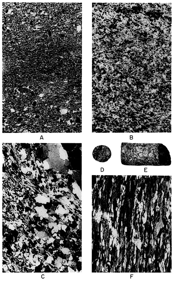
Plate 4--Quartz schist, quartzite, and "earlier" granitic gneiss, in thin section (all x19, except B, x12, crossed nicols). A. Quartz schist, cut perpendicular to plane of foliation. Rock composed almost entirely of quartz, here seen in various positions of extinction; only minor amounts of feldspar, partly decomposed, and muscovite mica. Barton County (36-19S-15W). B. Same rock as A, cut parallel to foliation, showing alignment of mineral constituents. C, Quartzite, sand-size fragments in feldspathic cement. Some grains rounded, others, which have been pressed together, more angular at their contacts. Ellis County (21-14S-20W). D. "Earlier" granitic gneiss, principally microcline and quartz in coarse alignment. Wabaunsee County (5-11S-10E).
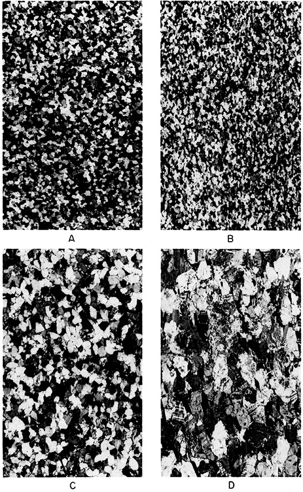
Plate 5--Rocks deformed during regional metamorphism, in thin section (all x34, crossed nicols). A. Muscovite quartzite. Quartz exhibits undulatory extinction, curved fracture, and lines of inclusions. Grains break across, and where not separated by muscovite, form interlocking mosaic. Flakes of muscovite arranged along margins of some quartz grains. Jumbled appearance of muscovite, and factors mentioned above, suggest that quartz grains have been reaccommodated under metamorphic pressure. Russell County (26-15S-13W). B, Cataclasis in "earlier" granitic gneiss. Mineral components have undergone considerable fragmentation. Same rock as Plate 4D, where its crude foliation is seen. Negative representation. Wabaunsee County (5-11S-10E). C. Exsolution phenomena in another section of rock shown in B. Subspherical quartz grains in deformed microcline.
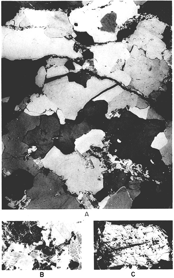
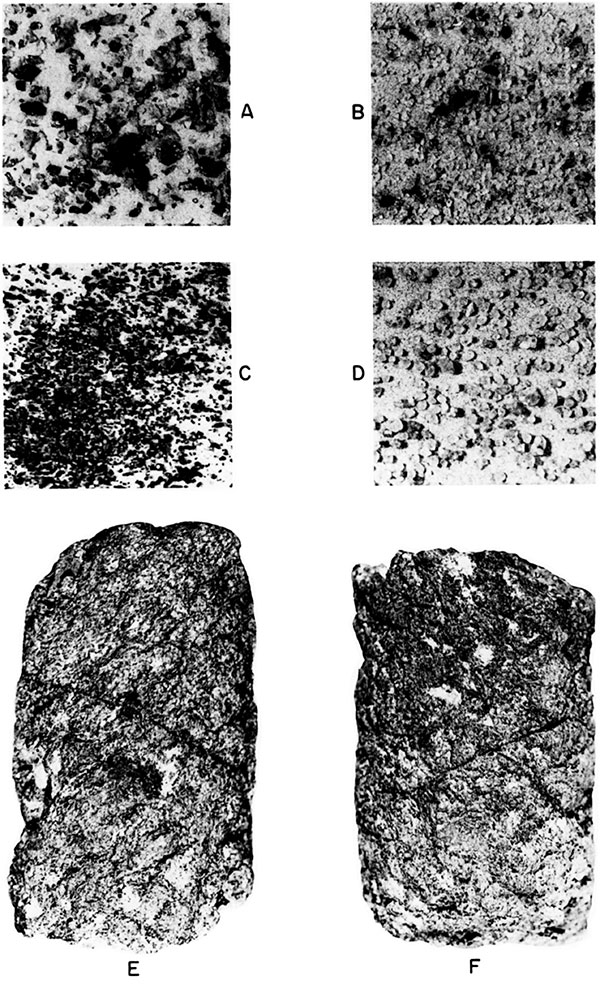
Plate 6--Granite and quartzite compared, in thin section and well cuttings (A-F x19, crossed nicols, G-H x27). A. Typical "later" intrusive granite, non-gneissic. Chief minerals microcline (cross-hatched), quartz (black, gray, and white, according to orientation), and oligoclase feldspar (one direction of twin lamellae, as near lower right corner); some mica, including both chloritized biotite and muscovite; accessory magnetite and apatite not visible in this view. One slide cut from material in same township shows euhedral sphene. General texture of "later" intrusive granite in Kansas is hypidiomorphic and granular. B. Muscovite quartzite. Muscovite appears speckled, has good cleavage, and somewhat ragged terminations. Very little feldspathic material. Quartz grains are pushed together with interlocking boundaries. Grain size is variable. This rock, in general texture and composition, is not unlike granite in A; in small cuttings granite and quartzite cannot always be distinguished without microscopic examination. Russell County (36-14S-14W). C. Granite, similar to A, but much finer grained. Norton County (25-5S-21W). D, E, and F. Granite. Three sections from same well. Feldspars are much decomposed; only in F are they clearly recognizable because of pronounced lamellar twinning. Russell County (6-14S-15W). G. Granite fragments, finer fraction from typical cable-tool cuttings. Pieces are angular and of different sizes. Larger chips, about 4 to 8 mm, provide material for thin sections. H. Quartz grains in size-sorted sample from Reagan (Lamotte) sandstone. Material in this Upper Cambrian sediment probably was derived from Precambrian rocks and partly rounded during transportation.
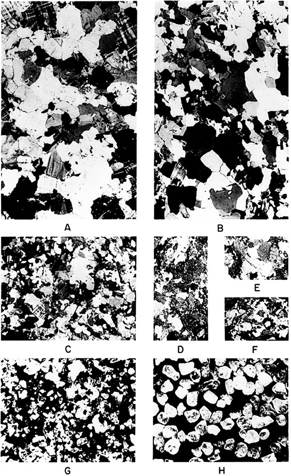
Plate 7--Cores of microgranite and "earlier" granitic gneiss. Same 3 1/2-inch cores in side view (above) and end view (below). Both have nearly vertical joint pattern, which appears in lower photographs as lines of fracture. A and C. Microgranite from 18-inch dike that cuts rock seen in B and D. B and D. Granitic gneiss; largest crystals white orthoclase feldspar, dull gray material quartz, and black streaks mainly biotite mica. Rock is regarded as "earlier" granitic gneiss rather than later intrusive granite because coarsely foliated. Both specimens from same well in Ellsworth County (8-14S-10W).
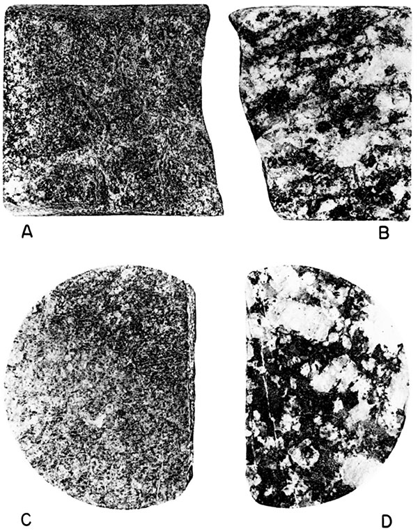
Plate 8--Intrusive and extrusive rocks of Precambrian age or later, in thin section (all x19 except E and F, x12, crossed nicols). A. Gabbro (same magnification as diabase, B). Mineral assemblage of A and B almost identical, labradorite ophitically included in augite; trace of olivine. Barton County (13-16S-12W). B. Diabase. Labradorite laths arranged at random in base chiefly augite but containing minor proportions of olivine (large fractured crystal just left of and below center). In composition and texture indistinguishable from extrusive basalt. Clay County (1-3S-7E). C. Syenite. Radially divergent grouping of orthoclase feldspar tablets is most notable feature of this dark brick-red rock. Other minerals, in order of abundance, are plagioclase, myrmekite, free quartz, hornblende, biotite, and magnetite. Rock may be classed as a quartz microsyenite. Barton County (24-16S-12W). D. Syenite. Mineralogically and texturally similar to rock in C, and in thin section resembles syenites from Custer County, Colorado. Russell County (24-14S-14W). E. Andesitic breccia (?), Brecciated and altered feldspar-bearing rock, unevenly cemented by quartz, which fills all voids. Corroded biotite, oxyhornblende, and shattered magnetite suggest an intermediate extrusive rock, such as andesite. Craig County, Oklahoma (19-28N-19E). F. Porphyritic felsite, an intrusive hypabyssal rock. In center is twinned crystal of orthoclase, surrounded by fine-grained matrix of quartz and feldspars. Stafford County (27-24S-13W).
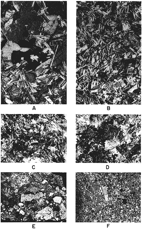
Plate 9--Typical Precambrian samples from Kansas wells (A-D, x2.7). A. Granite. Quartz and feldspar, and a few grains of mica. Fresh material generally salmon pink to pale buff. This is chief rock type in Kansas Precambrian. B. Muscovite quartzite. In addition to muscovite and quartz, small quantity of dark biotite is present. Russell County (27-14S-14W). C. Magnetite, from iron-rich band in quartzite. Russell County (24-15S- 14W). D. Hand-sorted quartz grains, from granular quartzite containing partly feldspathic cement. Barton County (25-16S-12W). E and F. Core of weathered "earlier" granitic gneiss. Opposite sides of 2 1/2-inch core cut in strongly foliated granitic gneiss. Lenticular masses are fairly fresh crystals of pink feldspar; other minerals much decomposed. Rock may be grouped with "earlier" granitic gneiss, this sample being from weathered zone near top. Faults and pockets of white kaolin are notable features. Cored 6 feet; 3 feet recovered. Russell County (31-13S-15W).
This investigation was undertaken in an attempt to interpret the geology of the oldest rocks in Kansas. These rocks are Precambrian in age and form a basement overlain by later sediments. Some of the state's oil fields are located above significant structures in the basement. The mineralogical composition of the Precambrian rocks is also examined. In the absence of surface exposures, the evidence comes entirely from boreholes.
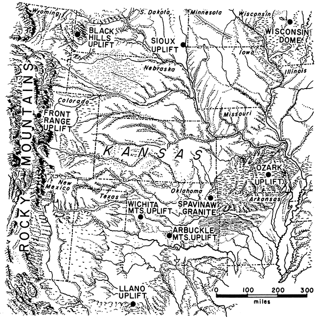
Kansas lies near the center of a wide section of the Midcontinent in which there are only a few areas of exposed Precambrian rocks. All these areas have undergone tectonic movement and regional uplift. They include the Rocky Mountains, Black Hills, Sioux uplift, Wichita and Arbuckle Mountains, and Spavinaw granite area (Fig. 1).
Figure 1--Precambrian rocks exposed in Midcontinent.
The Precambrian rocks of Kansas are not exposed, but crystalline rocks of this age extend everywhere beneath the later sedimentary formations and are encountered by any well drilled to sufficient depth. The Precambrian rocks form a basement complex, on which all the succeeding stratified rocks have been deposited. Most of the rocks described, therefore, are known to be older than the earliest of the Paleozoic sediments. The Precambrian subsurface of Kansas has been discussed briefly in a preliminary report (Farquhar, 1956),
Although the Precambrian surface was presumably a peneplain before the next series of rocks was laid down, it no longer has this attitude. Instead, it consists of buried ridges and basins developed during later periods of tectonic deformation. The Precambrian surface underwent the same changes in configuration as other deformed surfaces, and its present uneven nature is the result of at least four major contrasting structural movements.
Bedded rocks ranging in age from Cambrian to Pennsylvanian overlie and are in contact with the Precambrian. The Reagan (Lamotte) sandstone and the Bonneterre dolomite, both Upper Cambrian, are the most extensive and cover much of the Precambrian.
More than 1,600 wells have penetrated the Precambrian basement complex, and particularly in such producing areas as Norton, Russell, and Wabaunsee Counties, there are sufficient data to show the present attitude of the Precambrian surface and, in many places, the rocks of which it is composed. In other oil-producing areas, such as the developing Cunningham pool in the Sedgwick basin of south-central Kansas, knowledge of the Precambrian is gradually increasing. Occasionally information regarding the basement complex may come from sources other than the petroleum industry. One large metal-mining company, whose property extends from Oklahoma into southwestern Missouri and the extreme southeast corner of Kansas, includes drilling to the Precambrian surface in its exploration plans. Geophysical surveys also provide basement data.
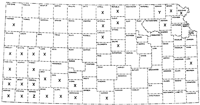
The shallowest depth from which rocks of Precambrian age have been recorded is 586 feet (588 feet above sea level) on the Nemaha anticline. (Fig. 2). The Precambrian surface slopes away from the granite core of this and other up arched areas, reaching depths of several thousand feet below the surface in the intervening structural basins. A few miles east of the Nemaha anticline the Precambrian surface is more than 3,000 feet below sea level, but rises again farther east across the Forest City basin.
Figure 2--Kansas county records of buried Precambrian rocks. Wells have reached Precambrian in about three-quarters of Kansas counties (all except those marked X). Shallowest record of Precambrian surface is in Nemaha County (Y). Greatest recorded depth is in Seward County (Z). Maximum thickness of sediments overlying Precambrian basement complex in southwestern Kansas probably exceeds 9,500 feet.
One of the deepest wells to reach the Precambrian surface was drilled to 4,645 feet below sea level in Barber County in the Sedgwick basin. In the deepest part of the Hugoton embayment of the Anadarko basin in southwestern Kansas, the depth to the Precambrian surface is estimated at about 9,500 feet. One well in Seward County reached crystalline rocks at 5,440 feet below sea level from an altitude of 2,823 feet, though this is believed not to be the deepest part of the embayment. The deepest part may be across the Kansas border in Oklahoma.
A map showing the distribution of wells reaching the Precambrian surface is included at the end of this account (Plate 1B). About 14 percent of all such wells have been drilled on the Central Kansas uplift in only ten townships, which together occupy no more than 0.4 percent of the state. The most detailed report on the Precambrian rocks of Kansas concerns part of this area (Walters, 1946). Across wide areas of the state, however, there are no wells reaching the Precambrian surface, and the configuration of this surface can be calculated only from records of overlying strata.
The subsurface samples of Precambrian rocks from wells in Kansas resemble crystalline rocks exposed in neighboring states, especially those in the Ozark Mountains of Missouri and the Rocky Mountains of Colorado. The Kansas rocks also may be correlated with subsurface Precambrian material of less distant areas.
The most comprehensive survey of the Precambrian surface in the continental United States appeared more than twenty years ago and recorded the major structural features then recognizable (Moss, 1936). Now, no doubt, the maps with the 1936 account would have to be modified as a result of further drilling. Bass (1956) is beginning a new petrographic examination of concealed basement in the area between the Appalachians and the Rocky Mountains.
In Nebraska, the Precambrian, known only from wells, has beep decribed by Lugn (1934). A map of the Precambrian surface has been prepared by E. C. Reed (unpublished).In Oklahoma, the Spavinaw granite, which crops out in the northeastern part of the state, is believed by Ham and Dott (1943) to be Precambrian in age, probably a relic of a Precambrian hill that rose above the level of Bonneterre deposition. The geology at Spavinaw also has been discussed by Strachan (1949), but the main point has been reiterated by Ham (personal communication, January 4, 1957) that "the evidence concerning Precambrian age for the granite at Spavinaw is just as clear as it is in the Arbuckle Mountains (Oklahoma), where granite hills 1,000 feet high are covered by arkosic dolomite of the Arbuckle group".
Recent work by Ireland (1955) includes a map of the Precambrian surface in northeastern Oklahoma and part of adjacent states.
Mention of the concealed Precambrian basement is made in certain publications dealing with eastern Colorado. Maher (1953) has discussed the structural development and Paleozoic history of southeastern Colorado. McCoy (1953) has described the Precambrian rocks of the Denver basin as a series of gneisses, schists, and other metamorphic rocks containing numerous igneous intrusions. The tectonic history of Precambrian rocks in Kansas may follow the general pattern of those in eastern Colorado.
Greene (1945) has reported on wells in northwestern Missouri. At the time of his account, drilling had not reached the Precambrian in this area, but on the basis of thickness of overlying sediments he calculated that the Precambrian surface in northwestern Missouri lies lower than that in the adjacent part of Nebraska. This agrees with knowledge of the shape of the Forest City basin in the northeastern corner of Kansas.
Two test wells in Vernon County, Missouri, adjacent to Linn County, Kansas, have penetrated 1,245 feet of pre-Upper Cambrian sediments, the lithology of which has been described by Skillman (1948). Eight major units of quartzite, siltstone, and shale have been distinguished, together with subordinate dolomite. Mineralogically there are certain similarities between these Missouri rocks and Precambrian metasediments in Kansas.
W. C. Hayes has initiated a study of the buried basement of Missouri.
In Texas and southeast New Mexico together, more than 800 wells penetrate rocks of the basement complex, described in a detailed account by Flawn (1956), who had written a progress report two years before (1954). Age determinations have been made for mineral samples obtained from certain rocks in Texas, and the age of lithologically similar parts of the basement complex in Kansas may be comparable. A chart of suggested correlations is included in this report (Fig. 4).
Totten (1956) has compiled a map showing the top of the Precambrian in the Texas and Oklahoma Panhandle areas.
A map of the Precambrian surface in South Dakota has been prepared by Petsch (1953). Investigation of rocks forming the basement complex is being undertaken by R. E. Stephenson.
Figure 3--Classification of Precambrian rocks of Kansas. (Numbers in A refer to lithologic groups in B.) A. Structural diagram, not to scale nor oriented, showing mutual relationships of typical Precambrian rocks. Basin in center (X) may be regarded as illustrating any large area that has been extensively downwarped compared with adjacent uplift (Y). B. Schematic arrangement.
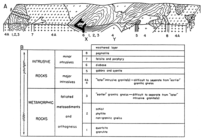
Figure 4--Suggested age correlations of Precambrian rocks in Midcontinent.
| Basement Complex of Some Areas in the Midcontinent | Basement Complex of Kansas | ||
|---|---|---|---|
| metamorphic and igneous rocks | age in million years |
relative age |
metamorphic and igneous rocks |
| pegmatite from Wichita Mountains, Oklahoma (Larsen, Waring, and Berman, 1953, p. 1121 ) | 635 | pegmatite | |
| intrusive granite from Wichita Mountains, Oklahoma (Larsen and others, 1949, p. 27) | 670 | "LATER" | intrusive granite(s) |
| intrusive granite from Llano uplift, Texas (Hutchinson, 1956, p. 792), ascribed to "middle" Precambrian age (Flown, 1956, p. 69) | 815 | "MIDDLE" | not represented, unless by some of the "toter" intrusive granite(s) |
| intrusive granites from Arbuckle Mountains, Oklahoma (Hamilton, 1956, p. 1328) | 900 | ||
| 980 | |||
| regional metomorphism of present "core" rocks, Black Hills, S. Dakota and Wyoming (Kulp, 1955, p. 627) | 1,500 | "EARLIER" | regional metamorphism of sediments and "earlier" granite, both now foliated |
Of the 105 counties in Kansas about three-quarters have at least one well reaching the Precambrian surface (Fig. 2). Granite and quartzite are the two chief varieties logged in oil wells, but several other types of rocks have been recorded, such as schist, gneiss, and pegmatite. A diagrammatic sketch showing structural relationships is given (Fig. 3A), and all the rocks are classified (Fig. 3B).
The Precambrian rocks of Kansas include a metamorphic group composed of quartzite, granulite, schist, phyllite, and gneiss (some granitic). This group has been intruded by a suite of igneous rocks consisting not only of granite, but also of some darker magmatic rocks. The intrusive granite is of batholithic dimensions and, like the metamorphic rocks it intrudes, is overlain by Upper Cambrian and later sediments.
The term "basement complex" is used in this report to refer both to the metamorphic group and the intrusive rocks, although their emplacement was probably separated by a long interval of time.
The metamorphic group consists not only of foliated metasediments but also includes seemingly interbanded granitic gneiss. The granitic gneiss, identified in microscopic section, is evidence that one period of granitic intrusion occurred prior to or during regional metamorphism. Thus the sandstones and shales, which were transformed into quartzites and schists, were intruded by an "earlier" granite, and both types of rock assumed the same pattern of foliation. This "earlier" granite is to be distinguished from the "later" granites, intrusion of which followed the regional metamorphism.
The interbanding of the "earlier" granite and metasediments is on a small and intimate scale. This suggests that, locally at least, the metamorphic rocks are "injection gneisses", comparable with those recognized in some of the world's great Precambrian shields. During regional metamorphism, pre-existing sediments were partly fused and injected to varying extent by magmatic material. Thus pre-existing sediment and original magma were brought into close relationship in a metamorphic environment when both were in the silicate-melt phase. Inevitably some degree of mixing took place, and the resultant rocks approach those known as migmatites (mixture rocks).
After regional metamorphism, the metamorphic group was intruded by granite that shows no foliation and clearly cuts across the older series. This is referred to here as "later" granite. It is unreasonable to suppose that all of this granite, of batholithic proportions, was intruded in a single pulse. The time interval between regional metamorphism and the end of the Precambrian was of immeasurably great duration. The vast quantities of granite intruded during this long interval may represent a succession of several phases of igneous activity.
Other major intrusive rocks that intersect the Precambrian basement complex are gabbro and syenite, plutonic rocks that have been detected in samples from a few wells in Barton and Russell Counties on the flanks of the Central Kansas uplift. In mode of occurrence and texture they are comparable with the more widespread granite, though having different compositions and mineral assemblages. Both the gabbro and the syenite. are presumed to be of Precambrian age.
There is a wide variety of minor intrusives belonging to the closing stages of igneous activity. One of these is a diabase, which in composition resembles the gabbro mentioned above. Diabase has been noted in only three widely separated localities, and its relationship with other rocks of the basement complex is uncertain. Dikes and sills, however, are presumed to be its chief forms, because it seems to cut both metasediments and intrusive granite. The possibility that in one place this rock represents a lava flow is discussed in the light of geophysical knowledge.
Minor acid intrusive rocks include felsite, porphyry, and pegmatite, the last being about as common as in any comparable exposed area, for example, the Colorado Rockies. Both the porphyry and the pegmatite are difficult to detect in rotary well cuttings, but in some of the bigger fragments from cable-tool samples their large grain size may be seen.
Considerable areas of Precambrian rocks are covered by a weathered top layer, the chief material being partly decomposed granite. The material of this weathered layer is Precambrian in age. The Precambrian surface is defined as the contact of the weathered layer with overlying sediments deposited in Late Cambrian and subsequent geologic time. The weathering is considered to have taken place in the Precambrian-Late Cambrian interval.
Basement samples,-Cores and cuttings from wells reaching the Precambrian surface were examined with the aid of the binocular microscope. Thin sections of certain cores and larger fragments were studied with the petrographic microscope. Representative photomicrographs made from these thin sections are reproduced.
Information available to the State Geological Survey of Kansas to the end of 1955 has been used.
Location of wells--In the text of this report well locations are given within a section (unit of one square mile), viz., Clay County (1-7S-3E). The numbers following the county name refer to section 1, township 7 south, range 3 east.
Continuation of present work--Current and planned extensions of the study include the following projects:
Receipt is gratefully acknowledged of a grant from the American Association of Petroleum Geologists to cover the clerical cost of preparing this list of wells.
R. C. Moore, whose writings have included consideration of the Nemaha anticline and other "basement" features in Kansas (1920, 1927), proposed this study of the Precambrian rocks on a state-wide basis. Robert F. Walters donated samples from Russell County and northeastern Barton County, which now are in the collections of the State Geological Survey of Kansas. He also read the manuscript. Sample logs prepared by the Kansas Sample Log Service were used to some extent, and Log No. 4860, by J, D. Davies, is quoted in part. Parts of the unlettered version of Erwin Raisz' "Landform Outline Map of the United States" form the background of Fig. 1: reproduction is by permission. Wendell Johns of Wichita loaned the cores illustrated in Plate 7. G. F. Jenks made the mileage computations (Plate 1D).
The older rocks of the Precambrian throughout the central United States, including Kansas, were subjected to pronounced regional metamorphism, which converted them from sandstone and shale into quartzite, schist, and gneiss. Before or during the regional metamorphism that transformed them into these types of foliated metasediments, the sandstone and shale were intruded by igneous material primarily of granitic character. These intrusive rocks received the same metamorphic impress as the sediments and thus appear as "earlier" granitic gneiss, both types being closely associated. In fact, quartzite and schist of sedimentary origin and granitic material of igneous origin are found banded and folded together. For convenience in this account they are referred to respectively as foliated metasediments and orthogneiss. All these metamorphic rocks were intruded by another suite of igneous rocks, again including granite ("later" granite). Together the metamorphic and igneous rocks may be grouped as the basement complex.
The "earlier" granitic gneiss thus antedates the postmetamorphic "later" intrusive granite, which is of batholithic dimensions. Wherever possible in sample examination, distinction has been made between these two types, which are of different age and texture but of the same mineral composition.
Material similar to this "later" intrusive granite is exposed in the core of the Wichita Mountains of Oklahoma. Its age has been determined as 670 million years by use of the zircon method (Larsen, Keevil, and Harrison, 1949, p. 27). As a hypothesis, the same age may be assigned to the "later" intrusive granite of Kansas. This age contrasts markedly with the period of regional metamorphism calculated for the Black Hills of South Dakota and Wyoming. Here regional metamorphism took place about 1,500 million years ago (Kulp, 1955, p. 627), and the date of regional metamorphism in the basement complex of Kansas may be closely comparable. Respectively, the two events, granitic intrusion and regional metamorphism, may be regarded as "later" and "earlier".
Flawn (1956, p. 69) gives a "middle" Precambrian age to the granites that form the core of the Llano uplift in central Texas. Hutchinson (1956, p, 792), in a detailed description of the Llano granites, gives an average age determination of 815 million years, Larsen's zircon method again being used. The Llano granites are petrographically unlike the "later" granites of Kansas. Zircon from porphyritic granite of the Arbuckle Mountains gives age determinations of 980 and 900 million years (Hamilton, 1956, p. 1328). This information is presented below in a more concise form, together with a suggested age correlation for Kansas pegmatite (Fig. 4).
In the absence of any definite chronological data from rocks of the Kansas basement, it is impossible to go beyond the mere suggestion of a formal time scale. There can be no advantage at present in attempted correlation with such Precambrian regions as the Lake Superior district, where a detailed succession has been made out, as summarized by Leith (1933). It is noted, however, that the figures given above may prove, as a result of further research, to be underestimates for a variety of reasons. Not least among these reasons is the recent increase in the minimum estimate of the age of the earth, stated by Holmes (1956) to be 4,500 million years, the most ancient crustal rocks to be dated approaching 3,500 million years old (Kulp, 1955).
Distribution--Quartzite, with which less common granulite may be included, occurs in bands and lenses interbedded with pelitic schists. In the Kansas metasedimentary sequence, quartzite is less abundant but more conspicuous than schist in typical well samples, much of the schist being disintegrated. Quartzite is encountered principally east of the Nemaha anticline and in the areas of the Central Kansas uplift and the Cambridge arch.
On the Central Kansas uplift the Precambrian surface has a relief of 200 to 250 feet. In general, the quartzite forms hills, masses of granite occupying the lower ground between. The quartzite hills seem to be isolated remnants standing above the otherwise almost level plain on which the extensive Bonneterre dolomite (Upper Cambrian) was deposited. Cross sections showing the relationship of quartzite and granite have been published by Walters (1946, 1953). The part of the Central Kansas uplift covered in the first of his reports is shown in Plate 1C.
Occasional cores have been cut in drilling through quartzite of the Kansas Precambrian, and one from Rice County (33-18S-10W) is illustrated in an addendum to the second report by Walters (1953, p. 313). Most of the well samples, however, consist of small chips obtained by drilling with cable tools.
The schistose quartzite of Kansas seems to be unlike the granulitic Sioux quartzite of eastern South Dakota and adjacent areas, with which the Precambrian quartzite of Nebraska has been compared by Condra and Reed (1943, p. 74). It is of course widely known that boulders of Sioux quartzite are found in Pleistocene drift spread over parts of the glaciated surface in both Nebraska and Kansas.
Petrography of quartzite--The chief mineral in Kansas quartzite is quartz, but almost all the samples contain some white mica, mostly muscovite. The proportion of muscovite averages between 4 and 8 percent by volume and is locally as much as 12 percent. Feldspar, epidote, chloritised biotite, magnetite, and graphite are present in small quantities, the dark minerals giving the rocks a slightly speckled appearance.
Texturally the quartzite is a granoblastic aggregate of quartz in recrystallized form. All traces of the clastic character of the original grains have been obliterated. Fragments have a vitreous luster.
Examples containing conspicuous magnetite are found in Barton (17-16S-12W) and Russell (31-14S-13W and 24-15S-14W) counties. A typical well sample from the last of these is illustrated by photomicrographs (Plate 9C). Quartzite speckled by magnetite and chlorite occurs with schist bands in Russell County (36-14S-14W).
Petrography of granulite--Compared with the muscovite-bearing quartzite, the granulite, which is much less common, contains very little mica. Generally it has no obvious schistosity and is more even grained and massive than the quartzite. Although both quartzite and granulite are very siliceous, the typical granulite contains more feldspar, its foliation being due to the approximate parallelism of flat lenses composed of quartz and feldspar.
Granulite may indicate a local increase in metamorphic grade above the average for the Kansas basement complex. A schistose variety from Barton County (24-16S-12W) has fragments of quartz unevenly distributed in certain bands (Plate 3A).
Discussion--Quartz-bearing rocks, both with and without feldspar, have been described above. Either type may be so schistose that it grades into quartz-muscovite schist. In this most of the mica flakes are of the fine variety known as sericite. In Russell County (34-15S-12W) one well was drilled 142 feet into a basement complex of banded quartzite and sericite schist. Near the base there is 7 feet of granitic material, which may be interpreted as a pegmatite or dike. Such penetrations into quartzite as 23 feet, 198 feet, and 683 feet in Russell (17-14S-14W, 27-148-14W, and 2-15S-14W) and 84 feet in Rice (21-18S-10W). Counties have provided adequate material for the study of this rock type.
Parts of a 29-foot section in Barton County (11-17S-11W) show quartz grains held together by a seemingly calcareous cement, possibly secondary. Evidence of calcareous material is rare, though one sample has been recorded in Nemaha County (33-2S-12E) of crystalline limestone at the Precambrian surface. This is discussed more fully in the description of that type. Some quartzite in Barton County (33-18S-15W) contains rare graphite flakes, indicating probable derivation from a carbonaceous sandstone.
Rutile needles are found as minute inclusions in quartz grains in a Russell County (36-14S-14W) quartzite. Because of these inclusions, it may be assumed that the quartz grains here have not recrystallized completely. More probably they have been derived from a pre-existing rock without much chemical change. Rutile needles are known to occur in the quartz of certain granites, though none have been noted specifically in Kansas granites. It is believed that the quartz grains containing rutile needles have been deposited after mechanical weathering from a rock of granitic type. In the samples examined, the quartz grains seem to be set in a partly recrystallized groundmass; i.e., metamorphism has affected the rock only to a slight extent. The comparative rarity of minerals indicative of the higher temperature ranges, such as garnet or sillimanite, in both pelitic quartzite and schist, indicates a generally moderate degree of regional metamorphism.
Other examples of quartzite containing sand-size fragments have been observed in samples from Ellis (21-14S-20W), (Plate 4C), Barton (25-16S-12W), (Plate 9D), and Pottawatomie (16-9S-9E) counties. Microslides show various degrees of rounding of the quartz grains, From their texture, as well as their mineral content, these rocks seem to have undergone metamorphism of medium intensity. In the Pottawatomie County locality noted above, the Precambrian is overlain by St. Peter sandstone (Ordovician), and the level of the unconformity is determined only with difficulty, the fragments in the metaquartzite below somewhat resembling the grains of coarse sandstone above. These quartzites fracture partly through and partly around single grains. In certain rocks individual sand-size fragments can be isolated by simple hand sorting (Plate 9D). Such a low degree of regional metamorphism is not common in the state as a whole, and quartzite in which adjacent grains are decidedly interlocked is more representative of the Kansas basement rocks.
Nearly all the quartzite samples examined, and particularly those containing muscovite, show signs of deformation. Several wells in Russell County (26-15S-13W) reached quartzite in which the edges of quartz grains are abraded on a microscopic scale. These examples of cataclastic texture result from mechanical deformation in response to pressure applied during metamorphism or at the time of subsequent tectonic events. In the same samples and others in Barton County (30-16S-11W) individual grains of quartz exhibit fractures and curved lines of cavities and inclusions, together with strain shadows, seen under crossed nicols as undulatory extinction. Where alignment of grains is prominent, as in the more schistose examples, contortion of the bands is proof of the stress to which the rock has been subjected. Small faults and mylonitised zones are further indications of the same phenomenon. Many of these microscopic features in deformed quartzite are illustrated in Plates 2 and 5A. The fractures are closed and do not necessarily increase porosity.
The fact that the muscovite-bearing quartzites tend to be schistose has already been mentioned. Most of the muscovite flakes are included, or partly embedded, in grains of quartz, despite which they display a marked alignment. In fact the schistose character of these rocks is due entirely to the muscovite. The alignment of muscovite while "fixed" in another mineral can be explained only by complete recrystallization of the other mineral, quartz, in one of two ways. One suggestion is that the muscovite flakes already may have been oriented before the surrounding silica became cool enough to crystallize in the form of enclosing quartz grains. They may be compared with torpedoes all steering about the same course and suddenly held in suspension when the medium became frozen. Many retain the same linear direction. More likely, development of quartz took place in a state of solid diffusion, the early-formed muscovite flakes being held in alignment by isostatic pressure, applied evenly along their length. Slight variations of this texture are seen in Plates 2A and 2B. In either case the rock has been severely deformed.
Though unusual, this microstructure of aligned muscovite flakes within crystalline quartz is not confined to the Precambrian quartzite of Kansas. Lahee (1952, p. 274), for example, figures a similar rock, presumably not from Kansas, in which biotite is oriented inside quartz, a development he attributes to "rock flowage". The same relationship between muscovite and quartz has been noted in a quartz-diorite gneiss from the Royal Gorge of Colorado, but unlike the Kansas quartzite, this originally igneous rock probably has not been entirely recrystallized.
Quartzite containing notable quantities of muscovite is found in several wells reaching the Precambrian rocks of the Central Kansas uplift. In Barton (20- and 21-16S-11W, 8-16S-12W, and 10-17S-13W), Ellsworth (7-17S-10W), and Rice (22-18S-10W) counties, there is quartzite in which most muscovite flakes are aligned within and around the quartz grains. When the rock is crushed by cable tools, the quartz grains tend to separate if muscovite is present between them.
Paleozoic rocks lie directly upon the Precambrian surface, which, as described more fully in another section, is weathered at the top in some districts. For example, there is 120 feet of this weathered material in one Norton County well. Although weathering has affected granite more deeply than quartzite, four wells in Rice County (33- and 35-18S-10W) record "eroded quartzite" at the Precambrian surface. Also in Rice County (26- 18S-10W) the top of a 44-foot section shows quartzite that is stained brownish-pink either by contemporaneous ground water or by material derived from the overlying formations and deposited from percolating solutions. Samples of one well in Russell County (16-14S-15W), reported merely as "Precambrian wash" in drillers logs, prove on further examination to be quartzite containing gneissic layers.
Quartzite (? ) weLL in Hodgeman County--One well in Hodgeman County (3-24S-24W), completed in 1952, after passing through only 8 feet of Arbuckle sediments, allegedly reached Precambrian rocks at a depth 300 to 500 feet higher than anticipated. On a map of the Precambrian surface this well might be thought to mark an upstanding volcanic plug or local horst. The well cuttings below the "Precambrian" contact resemble neither rhyolite nor granite wash, however. At first they were identified as quartzite, though somewhat doubtfully. The material consists of angular fragments of red, orange, yellow, and purple chert to which are added greenish and reddish pieces of crumbly shale. Most of the shale is washed out of the lower samples by longer water circulation.
Samples from this well have been described by Lang and Ver Wiebe (1954), who report approximately 80 percent chert and 20 percent detrital grains of quartz, plagioclase (mostly oligoclase), microline, and accessory minerals, all cemented by chert. The upper 4 feet is bluish-gray, and the lower part is reddish, the color being attributable to hematite staining. Unless this material is to be regarded as an integral part of he Arbuckle formation, the next matter to be considered should be the possible assignment of some other age.
There seems no reason to regard the chert as Precambrian. No similar material known to be Precambrian in age has been noted in Kansas. Monadnocks on the Precambrian surface in Barton County and in the southern part of Russell County are composed either of quartzite or granite.
Lang and Ver Wiebe consider the possibility that the chert is a residual deposit derived from part of the Arbuckle dolomite. They report, however, that in three wells within a radius of 15 miles there is no indication that the Arbuckle dolomite includes any chert.
The chert encountered may represent the filling of a sinkhole by material derived from rocks of the Osagian Series (Mississippian). The porous, white, chunky chert that these rocks contain, however, quite apart from the differences in color, does not altogether resemble the chert from the base of the Hodgeman County well.
Work by Redman (1947) in Rush and Pawnee Counties may help to explain the circumstances in which these chert fragments occur. Redman describes Simpson (Middle Ordovician) shale associated with angular chert fragments in sinkholes along the southwestern flank of the Central Kansas uplift. Sandstone and green shale of Simpson age certainly occur in the Hodgeman County well, though there is no record of them containing chert. The chance remains, however, that rolled chert from the existing land surface was dropped into a sinkhole about the end of Simpson time.
The chert fragments and crumbly shale in the Hodgeman County well match the description of the nonmarine conglomerate mentioned by Walters (1946, p. 697) as one of the sediments associated with the early Pennsylvanian surface on the Central Kansas uplift.
The main conclusion, stated briefly, is that the well in Hodgeman County (3-24S-24W) did not reach the Precambrian surface.
Distribution--Schist and phyllite have been recorded from several Precambrian wells in the eastern two-thirds of Kansas, schist being the more abundant. Both are products of metamorphic action on pelitic sediments, principally shales, mudstones, and clays.
Petrography of schist--The typical Kansas schist is composed principally of quartz but contains lesser amounts of feldspar, both biotite and muscovite micas, and such accessory constituents as hornblende, chlorite, epidote, tourmaline, garnet, sillimanite, graphite, and magnetite. Some of these minerals are flaky or tabular, especially the micas, hornblende, and chlorite. They are arranged in more or less parallel layers, thus emphasizing the schistose texture.
Several wells reveal good sections through schist (Plate 3B, C). The first of these is composed of quartz grains and aligned flakes of mica in continuous layers. In the second example the mica layers are not quite continuous, and the rock tends to be divided into lenticles, as in a gneiss.
Hornblende as an accessory is seen in a hornblende-chlorite schist lying below a hornblendite in the Beattie well of Marshall County (29-2S-9E), which penetrated no less than 1,580 feet of various Precambrian rocks. The lowermost 260 feet in the Milne No. 1 well in the southeastern part of Marion County (7-22S-4E) is believed to have been drilled in a hornblende schist. A thin section of a typical hornblende schist from Russell County (21-14S-14W) is illustrated in Plate 3F. A chlorite-schist core from Barton County (24-16S-12W) contains garnet porphyroblasts (Plate 3D, E). Another garnet-schist locality is in Barton County (13-17S-11 W-2 wells). The chlorite that colors some schists green is mostly secondary after biotite and hornblende. Sillimanite is rarely found and, because of its fibrous habit, is imperfectly preserved in well cuttings.
Two sections of quartz schist in which there are only minor amounts of feldspar, strongly decomposed, and some muscovite mica are illustrated in Plate 4A, B. This rock has about the same grain size as a coarse siltstone, and when the rock is cut parallel with the foliation the mineral constituents are seen to be strongly aligned.
Graphite has been found in a finely divided form in a few Precambrian schist samples from Barton County, and its significance may be briefly reviewed. Geologic evidence as to the chemical composition of the Precambrian atmosphere recently has been discussed by Rankama (1955); free carbon in the form of graphite and, by analogy, other carbonaceous materials in rocks of Precambrian terranes is explained by absence of atmospheric oxygen. This explanation applies as much to the Kansas basement complex as to the earth's great Precambrian shields.
Petrography of phyllite--Phyllite is rare in Kansas, but occurs, for instance, in Barton County (13-17S-11W). This rock is coarser than slate but finer than schist. Slender flakes of sericite mica are arranged along the foliation planes, giving broken surfaces a lustrous sheen. From its composition the rock may be allied with coarser-grained, less foliated, sericite-bearing quartzites like those of Russell County (34-15S-12W). The phyllite, however, has more mica and consequently better planar structure. Because fine-grained rock such as phyllite tends to be pulverized by the rotary drills, it may not be as uncommon as records indicate.
Discussion--In many wells schist is interbanded with quartzite and gneiss, and cut by later intrusives that may be Precambrian, such as pegmatite, Records of these wells show the compound character of the metamorphic group.
In Russell County (24-14S-14W) one well penetrated 170 feet of granite before reaching the metamorphic rocks, which are made up of schist and quartzite in disordered sequence. The sample of a well in Rice County (14-18S-8W) shows a similar interbanded arrangement of various metasediments, which include nongranitic gneiss. Quartzite and schist occur together in other widely separated localities, among them Phillips (31-5S-20W), Thomas (30-7S-32W), Russell (24-14S-15W), Barton (20- 16S-11W and 13-16S-12W), and Ellis (31-14S-19W) counties. Quartzite and schist also occur together in Pottawatomie County (33-6S-9E), but owing to looseness of the well wall and consequent mixing of samples, it is not possible to judge which of these rocks makes up the major portion of the basement complex at this point.
In Rice County (6-18S-10W) several wells cut a considerable thickness of schist over quartzite. Some of the schist wells are used for the disposal of salt water.
A 1,200-foot section of the Precambrian in Barton County (17-19S-11W), in a well evidently continued in error beyond the intended horizon, shows that the basement complex there is made up of dark, probably graphitic schists, some fine slaty bands, and ribs of quartzite. This well, completed in 1927, has been mentioned by previous writers, and samples taken at irregular intervals are available at Lawrence for examination. Several wells in Barton County penetrated alternating schist and gneiss.
Another locality indicating positively the relationship of schist and quartzite in the metamorphic series is in northern Greenwood County (4-24S-10E). Samples from the boring here, mentioned by Landes (1927, p. 822), show at least 650 feet of schist logged as shale. The last 30 feet was drilled in unmistakable quartzite, which no doubt convinced the drillers of the formation's age.
The log of a well drilled in Allen County (26-24S-18E) records 1,280 feet of metamorphic rocks. Quartz schist and quartzite were drilled in Phillips (33-1S-19W and 36-2S-19W) County, whereas in Rush (30-16S-18W) County such rocks are interbanded with foliated biotite granite. This well provides evidence of an "earlier" granitic intrusion before or during regional metamorphism. The granitic rocks are in the form of injection gneisses.
Nongranitic gneiss, like the schist and phyllite described above, owes its origin to the regional metamorphism of pelitic sediments such as shales, mudstones, and clays. The term "nongranitic gneiss" is used for gneissic material that has no evident igneous character and is therefore distinguishable from granitic gneiss.
The nongranitic gneiss is a coarse-grained but foliated rock. The banding is not precise as in a typical schist, mostly because quartz and feldspar predominate over the micaceous minerals. The quartz and feldspar form disconnected lenses separated only by undulating schistose layers of mica. The whole rock is grayish or brownish, in contrast to the usual salmon pink or red of the Kansas granitic gneiss.
Grayish biotite gneiss forms narrow stringers in the Precambrian section in Barton County (20-16S-11W and other points), but there is no definite evidence as to its derivation. The mineral assemblage, which includes quartz, two or three types of feldspar (micro cline or othoclase or both, and plagioclase), and two micas (biotite and muscovite), is similar to that of a granite; but the position of this rock seemingly as a member of the banded metasedimentary series leaves considerable doubt as to an igneous origin. Although some of the gneiss may represent an extreme case of lit-par-lit intrusion of magmatic material, a metasedimentary origin for part of it is considered likely. In either case this rock belongs to the metamorphic division of the basement complex rather than to the "later" intrusive suite of rocks.
Certain foliated rocks in parts of Russell County are pink or red, and especially where they dominate the rock series, they are regarded as "earlier" granitic gneiss and are discussed under that heading.
The sample log of a well in Rice County (14-18S-8W) shows 500 feet of Precambrian materials comprising quartzite and schist in addition to nongranitic gneiss. Examples of non granitic gneiss also occur in Rooks (27-6S-19W and 24-6S-20W) and Russell (31-13S-15W and 21-14S-14W) Counties. In the last-mentioned well the micas are heavily stained and chloritized.
Several well sections provide evidence that the metasediments are cut by postmetamorphic pegmatite, to be described later. Schist and gneiss in Russell County (35-14S-14W) are ribbed by quartz, which may be vein material. This becomes more abundant with depth. In Phillips County (1- and 20-4S-19W) there is white quartz that may be either new vein material or merely a recrystallized product of metamorphic segregation, possibly forming a coarse siliceous gneiss. There is no definite evidence as to the origin of this rock, but its derivation from a sediment seems more probable.
Crystalline limestone, if present at all, is not common in the Kansas basement, but has been noted in drillers logs for wells in Nemaha (33-2S-12E) and Marshall (Frankfort well) Counties. Samples are not available for examination, but the material may have been impure marble. There is not sufficient information to establish crystalline limestone as a Precambrian constituent in Kansas.
Calcareous fragments from the bottom of a well in Rush County (21-17S-16W) may be from the Precambrian but are not large enough for the preparation of thin sections. Calcareous cementing material has been noted in one or two quartzite specimens, but this does not necessarily indicate the composition of the original sediment. The calcium carbonate may be later in some samples, though in others the clastic texture of the grains indicates that they are original.
The presence of quartzite with calcite suggests that the sediments laid down in Precambrian time were not entirely without lime, at the same time recalling the suggestion half a century ago that the ocean waters themselves may have been limeless (Daly, 1907). Daly's explanation for the absence of lime in solution was its precipitation by ammonium derived from decaying organisms. When scavengers appeared, geologically late, they retarded putrefaction of organic matter on the ocean bottom. As precipitation was slowed up, calcium salts became more concentrated, and shelled invertebrates were enabled to flourish.
Introduction--Granite is by far the most common rock in the basement complex of Kansas, occurring in two entirely different ways. In the metasedimentary series of quartzite and schist, granite forms bands and masses injected shortly before or during regional metamorphism. This granite is markedly gneissic in texture. Granite also appears as large-scale intrusions postdating the regional metamorphism, showing a predominantly hypidiomorphic texture, which is typical of plutonic rocks. The first type is in the form of lit-par-lit injections, whereas the second type occurs as major batholiths cutting the first. They may be summarized as follows:
Petrography--The chief minerals in the "earlier" granitic gneiss, as well as in the "later" intrusive granite, are quartz, orthoclase, microcline, plagioclase, muscovite, biotite, and a variety of accessories. A microline-bearing granite from Wabaunsee County (5-11S-10E) is distinctly gneissic (Plate 4D). Locally this rock, an "earlier" granitic gneiss, shows a cataclastic, or shattered, texture, possibly brought about by postmetamorphic intrusions or other disturbance (Plate 5B). Exsolution phenomena in another section of this rock may be attributed to the same causes (Plate 5C). Here subspherical quartz grains are held in deformed microcline.
The gneissic texture of the metamorphosed "eanlier" granite may not be visible in small well cuttings; hence positive distinction in some samples is extremely difficult, but in other samples the granite has an unmistakable foliated appearance. Quartz and feldspar form undulating bands, locally divided into separate lenses and parted by micaceous layers. Typical examples are seen in Plate 9E, F. Other examples of "earlier" granitic gneiss, also distinctly foliated, are shown in Plate 7B, D. Fresh material is red or brown.
Discussion--In attempting to distinguish the "earlier" granitic gneiss from the nongneissic "later" granite, factors other than foliation have been taken into account wherever the degree of foliation has proved inconclusive. Interbanding with metasediments generally indicates that the granite is metamorphic and "earlier", though such metasediments in places also are cut by granite dikes. These dikes have the same mineral composition as the "later" granite and are notable for an absence of foliation. The dikes probably are direct offshoots of the "later" granite.
The most distinct area in which orthogneiss occurs is Russell County, where several wells have been drilled through quartzite, schist, and pinkish-red granitic gneiss, all inter banded and making up a single foliated series. It is this rock especially that is assigned to the category of "earlier" granitic gneiss.
In a detailed consideration of Precambrian rocks in central Kansas, Walters (1953, fig. 4B, 5B) shows cross sections in which schist is locally overlain by granite. The two wells concerned, both in Russell County, are located in 24-14S-14W and 4-14S-15W, and respectively they drilled through 170 feet and 26 feet of fresh biotite-hearing granite before reaching schist. These thicknesses are too great to be interpreted as sills in either case, and from the evidence of adjacent wells there seems no reason here to postulate reversed faults in the basement.
The explanation offered is that the granite is part of the interbanded metamorphic series and represents the "earlier" granitic gneiss. The well cuttings. though only small chips. show some evidence of foliation. In the second well another band of seemingly foliated granite was penetrated beneath the upper part of the schistose metasediments. Also, there are other wells in Russell County in which the metasediments and "earlier" granitic gneiss are interbanded.
"Later" intrusive granite is the most widespread rock in the Kansas Precambrian, occurring in almost all areas except those occupied by rocks of the metamorphic series.
Petrography--Generally the "later" granite can be distinguished by its nonfoliate texture from the "earlier" granitic gneiss, which is interbanded with the metasediments of the basement .complex. The main characters of the two granites are contrasted in the previous section of this report. Because of the small size of the well cuttings, it is not possible to recognize the distinction in every sample, although the textures in suitable material are seen to be markedly different.
The texture of the "later" granite is essentially hypidiomorphic and granular, though the grain size varies considerably. In Norton County (27-2S-23W) one sample showed great disparity, the orthoclase feldspar being almost porphyritic and the micas tending to form aggregates. By way of contrast, in a Russell County well (7-12S-15W), a 58-foot penetration of the Precambrian yielded granite that was both equigranular and mineralogically uniform throughout.
Excellent, fresh samples of granite may be obtained either from the Precambrian surface or below the weathered top. Much of the rock is salmon pink. There is a characteristic suite of minerals. An average mode is given below:
| Mineral | Percent |
|---|---|
| Quartz | 25-30 |
| Orthoclase and microcline | 40-50 |
| Plagioclase (c. Ab75An25) | 20-25 |
| Muscovite | 2-3 |
| Biotite | 1-2 |
| Magnetite and other accessories, including zircon, sphene, hornblende, tourmaline, apatite |
1 |
Photomicrographs of rocks of this type are shown in Plate 6A, C-F.
Discussion--The texture and mineral composition described above are typical of granites that form plutonic intrusions of batholithic dimensions. Cable-tool samples consist of angular mineral fragments, the feldspar breaking for the most part along recognizable cleavage planes and the quartz into subconchoidal pieces. By contrast, quartz grains from the Reagan sandstone (Cambrian) are subangular, probably being derived from Precambrian granite or quartzite. Fragments of Precambrian granite and Cambrian quartz grains are compared in Plate 6G, H.
Much but not all of the granite on the Central Kansas uplift seems to be postmetamorphic and therefore "later". For instance, one well in Russell County (19-14S-13W) penetrated 114 feet into granite that shows no foliation. Similarly on the Nemaha anticline, as in Nemaha County (16-2S-13E), most granite in wells is normal plutonic type.
One of the deepest wells to enter the Precambrian rocks was drilled in Barber County (19-33S-12W). This struck "later" nonfoliated granite at a depth of 4,645 feet below sea level. In Montgomery County (7-32S-16E) "later" granite has been recorded at 2-foot intervals for more than 100 feet. The rock is pink and is composed of feldspar (about 70 percent), quartz (about 25 percent), and micas (about 5 percent).
Along the axis of the Nemaha anticline a Woodson County well (29-25S-16E) intersects granite composed of reddish orthoclase, quartz, and chloritized biotite. The replacement of biotite by chlorite is more noticeable in samples from the surface than in those from below, although not confined to the zone of weathering. The same process of chloritization has affected granite below the Precambrian surface at other places, as seen in samples from Norton (12-3S-23W) and Decatur (3-4S-27W) counties.
The highest elevation of the Precambrian surface is in Nemaha County (33-2S-12E), where granite lies only 586 feet beneath the present land surface and 588 feet above sea level. The top of the granite on the Nemaha anticline shows mainly fresh rock, but a moderate thickness of residual weathered material is found in a few wells.
Drillers logs of certain wells state only "Precambrian", whereas the samples examined clearly consist of a definite lithologic type. Thus, in Phillips (29-4S-20W) and Russell (25- and 29-14S-14W) counties, "granite" can be established as the variety present, though the individual character of Precambrian rock is not mentioned in the log. On the other hand, in nearby wells in Norton County (19-4S-22W and 26-5S-22W), where granite is positively recorded, the samples show only an indeterminate clayey material. The logs for two other wells in Norton County (25- and 36-5S-21 W) specify "quartzite", though the available samples have apparent granite. The second well reveals a bleached granite sand capping a fresh pink microcline-bearing, unfoliated "later" granite. Granite, rather than the quartzite logged, appears also in samples from Barton (5-16S-13W and 29- 19S-14W) County.
In fragmentary well samples of both granite and quartzite, quartz is much the most common constituent--in a Norton County well (23-4S-23W), for example, the "granite" is almost all pinkish quartz. But for comparison with samples from adjacent wells that show granite composed of pink quartz, some feldspar, and micas, this material might be identified as a pink quartzite. Feldspar, the other common mineral of the granite, also is mostly pink or buff, and if the sample is ground to angular fragments during drilling, diagnosis may be difficult. Again, in northeastern Kansas, both granite and quartzite may be pink or red.
In some granite areas the feldspar near the Precambrian surface has been chemically decomposed, and the action of drilling is sufficient to disperse it mechanically. In this event the sample collected may contain little mineral material except quartz and muscovite, the latter being more stable than the other common mica, biotite. Thus the chief constituents in some samples from wells cut through granite are the same two minerals, quartz and muscovite, that occur in the most notable metasediment of the Kansas Precambrian, a muscovite-bearing quartzite. The distinction between main rock types, far from always being clear, sometimes is made more difficult by the small number of determinative constituents. Typical specimens are compared in Plate 6A, B and in Plate 9A, B.
Samples obtained under the drilling conditions just described for partly weathered rocks may be unfavorable for microscopic examination. Even some fresh mineral materials may be reduced almost to rock flour by use of the churn drill on hard Precambrian rocks. The proportion of quartz examined therefore may be higher than in the actual rock drilled, and all microstructures may be entirely destroyed. In these circumstances granite and quartzite are not easily distinguished from each other or even from sandstone. Passing through the base of the Paleozoic column across the Precambrian-Paleozoic unconformity, one may experience difficulty in assigning a lithologic title to amplify the identification "Precambrian". Gneiss and schist, unless thoroughly disintegrated, are easier to distinguish.
In many granite samples, such as those from a group of Russell County wells (25-14S-14W), albite twinning in the plagioclase feldspar can be seen with the binocular microscope, the hand lens, or even the unaided eye. Both micas may be present in significant amounts, as in Barton County (10-18S-14W), but granite containing only biotite and no muscovite was found in another sample from Barton County (11-16S-15W).
An extreme case of biotite enrichment in the Precambrian basement was revealed by the Frankfort No. 1 Kuck well in Ellsworth County (8-14S-10W), granite being penetrated for several hundred feet. Samples, which start at a depth of 3,300 feet below a collar 1,803 feet above sea level, were examined by the Kansas Sample Log Service (Log. No. 4860). In the Precambrian "granite wash", beginning at a depth of 3,990 feet, there are "deeply weathered granite fragments, quartz grains and pebbles, biotite mica books and fragments of partially kaolinized pink feldspar." The fresh biotite granite begins at 4,071 feet and is "very coarse-grained … composed of fresh-looking biotite (35 percent average), pink and white feldspar, some magnetite and traces of hornblende and tourmaline." The quartz is a clear variety.
The well was cored for 21 feet (from 4,295 feet), mainly through biotite granite, which seems to be coarsely foliated and probably belongs to the "earlier" phase of pre metamorphic granitic gneiss. The largest crystals are whitish orthoclase feldspar. An 18-inch streak of pinkish-gray micro granite starts 5 feet below the top of the core, and near the bottom there is a white vein of clear quartz and feldspar. The cores show a nearly vertical fracture, as seen in illustrations of both microgranite and "earlier" granitic gneiss (Plate 7).
Various suggestions for the unusually large proportion of biotite are made. First, there may be a nearly vertical pegmatite, in which the books of mica are associated with an otherwise normal assemblage of granite minerals. Second, the percentage of biotite in the washed sample may not be properly representative of the rock type, perhaps as a result of greater feldspar disintegration than is customary. The fast drilling to some extent suggests lack of coherence, and yet the samples do contain some fresh feldspar, which would act as a binding factor in unaltered rock. Third, the granite in this section of Ellsworth County may be so juxtaposed to a pre-existing rock that the biotite-rich fraction is in the nature of a contact or skarn deposit. Last, this fraction may represent simply local concentrations or schlieren of biotite in granite, as found in exposed granite areas such as the Colorado Rockies.
Dark minerals, mostly tourmaline, hornblende, and magnetite, are conspicuous in granite samples from Decatur (28-2S-28W), Norton (22-3S-23W), and Rawlins (32-4S-35W) counties.
One of the most recent wells to hit granite (February 1956) is in Kingman County (30-27S-10W). Skelly Oil Company deepened the No. 1 "A" F. C. Miles well, which previously had been stopped at the Lansing group (Pennsylvanian) and was the discovery well of the Cunningham pool. Granite was reached at a depth of 4,936 feet (surface altitude 1,675 feet). The Precambrian surface at this point in the Sedgwick basin therefore lies 3,261 feet below sea level.
As a rock type in the Precambrian of Kansas, granite has received more attention than any other. Periodic reports of wells reaching granite have included short descriptions and theories as to origin. For example, Powers (1917) listed 12 wells drilled into granite to the year of his account. All were along or near the Nemaha anticline, upon which many other wells have since reached granite. On the basis of some of these wells, Wright (1917) discussed the nature of the granite and favored a "mountain" hypothesis. All the Kansas wells that had reached granite by the end of the next 5 years were listed by Powers (1922), who also discussed the importance of reflected buried hills in petroleum geology. A further account was given in the following year of all the granite wells in Kansas to that date (Gould, 1923). The total then numbered 30.
Considering the vast extent of granitic rocks in the basement complex of Kansas, assigned to periods both before and after regional metamorphism, it seems that intrusion was of multiple character. The "earlier" granitic gneiss and the "later" intrusive granite provide the most conclusive evidence of igneous activity at more than one period. But the "later" granite, which forms the great bulk of the basement complex, may also represent successive igneous pulses rather than a single phase of intrusion.
Concerning the earth as a whole, Daly (1951, p. 36) has made an interesting comment, which has a bearing on the profusion of granite in such sections of the basement as Kansas: "Since the late Archean the eruption of granite on a large scale has been confined to the narrow belts of mountain-building; but granitic eruption affected every part of the Basement Complex …" Various theoretical inferences may be drawn from this contrast between the behavior of the lithosphere in Precambrian time and in post-Precambrian time, the latter constituting less than one-sixth of the geological record. The fact remains, however, that granite forms by far the larger part of the Precambrian basement under the Kansas segment of the Midcontinent.
Closely associated in composition with the "later" intrusive granite (s) is syenite, to be described in a later section.
Gabbro is found in Barton County (13-16S-12W); a photomicrograph shows the appearance of this rock in thin section (Plate 8A). Its texture is hypidiomorphic and granular. Plagioclase feldspar (labradorite) and augite are present in almost equal amounts. There is very little olivine, and magnetite is the chief accessory constituent.
Only one well is known to penetrate this type of rock, although material in Precambrian wells in Rice County (33- and 34-19S-10W) may be similar, having been reported as black. Nevertheless, the gabbroic rock of Kansas may belong to a plutonic mass of considerable proportions, sufficient to be classed as one of three distinct postmetamorphic major intrusives.
Gabbroic rocks both in the Wichita Mountains of Oklahoma and in the buried Swisher terrane of New Mexico and Texas are given a Precambrian age by Flawn (1956, p. 46). Although the Kansas well is several hundred miles fror.i these occurrences, some genetic relationship is possible. At least there are close mineralogical similarities, and it is suggested that rocks from the three areas all belong to the same petrographic province. Even so, it would be unwise to make a definite assumption of any subcontinental connection without proof of the same age.
Distribution--Syenite has been recognized in several wells of northeastern Barton County. Its nonfoliate texture indicates that it undoubtedly belongs to a suite of postmetamorphic intrusive rocks. Walters (1946, p. 674), referring to syenite from this area, described the upper few feet as a "clayey, structureless red rock." Below this weathered top, probably representing an old land surface, there is fresh syenite.
Petrography--Although the rock contains a small amount of quartz, it is classified as syenite. An average mode of mineral constituents is given below:
| Mineral | Percent |
|---|---|
| Quartz 1-8 | |
| Orthoclase | 45-55 |
| Plagioclase | 30-35 |
| Hornblende | 5-15 |
| Mica/chlorite | 1-2 |
| Magnetite and others | 1-2 |
The quartz differs considerably in proportion and occurs both free and in myrmekitic intergrowth with plagioclase feldspar. In some examples orthoclase, twinned according to the Carlsbad law, is arranged in a crudely radiating pattern. Hornblende and mica, present in minor amounts, are altered to some extent, and the hornblende may show peripheral corrosion. In some of the finer-grained samples quartz forms a larger part of the rock, which may then be called a "quartz microsyenite".
The grain size of the syenite is medium to fine, and the rock has the typical hypidiomorphic texture of a plutonic intrusive. Porphyritic crystals have not been observed. Microscopically, the most distinctive textural feature of the Kansas syenite is the radially divergent grouping of orthoclase feldspar tablets. Cuttings of the rock are grayish red. Thin sections illustrating some of these features appear in Plate 8C, D.
Origin--Three possibilities are suggested in regard to the origin of the syenite.
Age--It is difficult to ascribe a definite geological age to the syenite or to any of the igneous rocks intruded after the regional metamorphism of the Precambrian sedimentary series, except for the intrusive granite of batholithic dimensions. This is clearly Precambrian, being capped over large areas by unmetamorphosed younger sediments. Most of the granite pegmatites bear such close mineral affinities with the batholithic granites underlying Cambro-Ordovician sediments that they also may be included as Precambrian.
In regard to other rocks, such as syenite and diabase, recognized at the approximate level of the Precambrian surface, there is little evidence against their belonging to a Paleozoic or later suite of intrusive rocks. All of them are narrow, cross-cutting bodies, which seem to be confined to the Precambrian but possibly may extend through some of the later strata.
Unless all the evidence is considered, the syenite under discussion might be linked with certain post-Precambrian rocks. There are several post-Precambrian igneous rocks in Kansas to which the syenite could be related genetically, if not temporally. These include the granite of the Rose Dome in Wilson County (Hambleton and Merriam, 1955) and a sill-like peridotite mass that cuts Pennsylvanian sediments in Woodson County, described by Knight and Landes (1932) and Wagner (1954). Also, there are five peridotite plugs in Riley County, the features of which have been summarized by Byrne, Parish, and Crumpton (1956), after earlier descriptions of some of the same rocks by Moore and Haynes (1920) and Jewett (1941).
It is therefore necessary to examine in detail any information bearing on the relative time of syenite intrusion. In Barton County (23- and 24-16S-12W) there are wells in which syenite is much weathered at the Precambrian surface. The overlying sediments are Pennsylvanian in age, thus fixing the syenite as pre-Pennsylvanian. Further evidence is provided by a well in Russell County (24-15S-14W), mentioned by Walters (1953, p. 309), in which syenite underlies schist. The schist in turn is overlain by Cambrian sandstone and is therefore Precambrian. The syenite intrusive into the schist probably is Precambrian, but from the evidence of this well a later age is not excluded. The syenite is not weathered at the top, and it may be a stringer that cuts later rocks as well as Precambrian material.
Most of the wells that encounter syenite at the level of the Precambrian surface show this rock to be deeply weathered. The extent of weathering is at least as great as in other rocks encountered on the Central Kansas uplift and regarded with certainty as Precambrian. The characteristic deep weathering may be an indication that the syenite formed part of a surface that was exposed to leaching and alteration after Precambrian time as well as during the Mississippian-Pennsylvanian interval. This fact is used in support of the view that a Precambrian age for the syenite is more than probable.
Syenite closely resembling the samples examined from Barton County, Kansas, cuts steeply across upturned gneiss and schist in the Wet Mountains and adjacent areas of Colorado. An example was described many years ago from Custer County (Diller, 1898, p. 183-186), but its age cannot be fixed with greater accuracy than pre-Tertiary.
Distribution--Diabase occurs in at least one Kansas county and possibly in two others. In Clay County this rock has been verified by microscopic examination; it will be considered at some length in the discussion that follows. Diabase (or diorite?) also is mentioned as lying below the granite surface in Chase County (34-19S-7E) (Taylor, 1917). The 60-foot section probably cuts through a dike. A whitish rock in Phillips County (28-5S-20W) may be a weathered diabase sill; the samples are much decomposed.
Petrography--The diabase mineralogically is similar to the gabbro already described from Barton County, containing almost equal amounts of plagioclase feldspar (labradorite) and augite. There is some olivine, and iron oxide in the form of magnetite is the principal accessory.
In texture the diabase is much finer than gabbro. It displays an ophitic relationship between the plagioclase laths, which are arranged at random, and the crystals of augite, which partly surround them.
It is likely that the diabase and gabbro are derived from the same magmatic source and, though not intruded at precisely the same time, have a close genetic affinity. Both are comparative rarities in the Kansas basement. A thin section of diabase appears in Plate 8B, the rock being described in the caption.
Discussion--Members of the gabbro-diabase group in the Kansas basement merit special attention. For instance, in Clay County (1-7S-3E), Precambrian material, reported only as "quartzite", is interbanded with a rock that may be either diabase or basalt. This basic rock may represent either a subconcordant diabase sill or, more likely, a series of basaltic lava flows overlying other Precambrian materials. Recent geophysical investigations may have a bearing on the Clay County "basalt" and will now be considered.
The surface of Precambrian rocks is about 2,000 feet lower in this area than over the Nemaha anticline about 50 miles farther east. Measurements of the gravitational and magnetic anomalies along this profile made at intervals of approximately 7 miles during a coast-to-coast survey were reported by Woollard (1943). From the uneven nature of the Precambrian surface as recorded from deep borings, geophysical studies might have been expected to show corresponding anomalies of some magnitude. Over the Nemaha anticline, however, the total observed effect was no more than a small percentage of the calculated anomaly, which Woollard explains by lack of contrast between the density of the granite and the density of the overlying sediments.
There are naturally many corrections for compaction, polarity swing, and other factors, which can be applied to the gravity calculations, but there may be some fundamental cause for this lack of contrast. Perhaps it is due to the presence of unusual and hitherto unrecognized rocks in the basement rather than solely to configuration effects. Woollard's cross sections convincingly demonstrate an appreciable difference, however, between the area near Clay Center in Clay County and the Nemaha anticline. The former stands out as an unmistakable high in clear gravitational and magnetic profiles. Woollard (1943, p. 783) notes that the high at this point "appears to be related to a very large subsurface mass that is probably gabbro", that is, a rock having a composition almost the equivalent of basalt.
A few years after the results of Woollard's transcontinental traverse were published, an airborne magnetometer survey was made along the 40th parallel (the Kansas-Nebraska line) and reported by Jensen (1949). The route flown passes about 45 miles north of the basalt observed in the Clay County Precambrian. The Nemaha anticline, mostly of granite, has approximately the same cross section at the 40th parallel as at the latitude of Clay County. The profile obtained by the continuous magnetometer survey shows a magnetic low across the Nemaha anticline, which perhaps results from changes in the earth's magnetic field. It also shows a conspicuous positive anomaly north-northeast of the Clay County diabase. Minor ripples in this profile may be related to such post-Precambrian features as the Abilene anticline or the Barneston anticline, described by Jewett (1951), or they may be attributed to certain Mesozoic ultrabasic rocks such as the intrusives in Riley County, between Clay County and the Nemaha anticline.
The positive anomaly north-northeast of Clay County may have some significance in relation to the Precambrian lithology of Kansas, just as Woollard has speculated concerning the area near Clay Center. In both areas there may be basalt. So far as the Clay County well (1-7S-3E) is concerned, this interpretation simply attributes the dark igneous rock to a basaltic lava flow instead of a diabase sill, rocks which are often indistinguishable in the laboratory. Woollard's "gabbro", although having a different texture, may be expected to give a similar magnetic response.
Some additional evidence has a bearing on this question. A recent map of regional gravity in the United States has as one of its outstanding features a "high" extending from northern Michigan across the intervening states into that part of northeastern Kansas where Clay County is situated. This map (contour interval 10 milligals) was assembled by Lyons (1950), and certain portions have been discussed by Logue (1954) and others. Some of the early work that led to this map was carried out in areas of Wisconsin adjacent to northern Michigan by Aldrich (1923).
There seems little doubt that the high in northern Michigan is caused by Precambrian lavas that crop out there. In northeastern Kansas, at the other end of the line, basic rocks, again Precambrian though here subsurface, may be responsible for similar anomalies. In between, there are other examples of basic igneous rocks in the basement complex. Precambrian material in a well just east of Lincoln, Nebraska, "seems to be quartzite with some intruded basic igneous rocks" (Condra and Reed, 1943, p. 74).
Reference has been made to anomalies in Kansas observed by both Woollard and Jensen, in traverses respectively across or near the Clay County "lava". There is some evidence that basic, more magnetic, basaltic rock in the low area of Clay County makes a more positive element, geophysically, than siliceous, less magnetic, granitic rock on the ridgelike Nemaha anticline. Parenthetically, it may be noted that in geophysical profiles farther south across the Nemaha anticline, a similar "low" anomaly has been observed. Also, the presence of a high over a basic igneous rock is not unusual.
In conclusion:
Hornblendite has been reported from Marshall County (29- 2S-9E). Nothing further is known except that a hornblende schist lies below the supposed hornblendite. This rock series may be in the form of a hornblende-bearing dike, though the name hornblendite normally would indicate an ultramafic variety of deep-seated intrusive.
A much altered rock resembling a hornblende andesite occurs in the Precambrian subsurface of Craig County, Oklahoma, only a few miles south of the Kansas line. This may represent a local extrusive flow, but the evidence is confined to samples from a single well. A slide of this material (Plate 8E) shows a brecciated rock containing a much-corroded dark mineral, probably hornblende, and andesine feldspar. The brecciation may have been caused by explosive activity during the crystallization stage. Former voids in the rock are filled with quartz, mosaically arranged.
As a group, the minor acid intrusives make up a very small proportion of the basement rocks. They are somewhat diverse in character and include felsite, porphyry, and pegmatite, any of which may occur as subconcordant sill-like masses or crosscutting dikes. Quartz, orthoclase, and muscovite are the chief constituents. The grain size of the porphyries and pegmatites considerably exceeds that of normal granites.
Felsite--Felsite is recorded from Stafford, County (27-24S- 13W). This variety is porphyritic (Plate 8F). Another variety of felsite, which is nonporphyritic and may equally well be described as a microgranite, occurs in Ellsworth County (8-14S-1{)W). A core of this material is illustrated in Plate 7A,C, together with the "earlier" granitic gneiss that it intrudes.
Porphyry--Porphyry occurs in Chase County (2-20S-7E), according to drillers logs. It is not known whether this rock resembles the porphyritic felsite described above. No descriptive data are available, but the so-called porphyry may represent an extrusive lava flow, possibly rhyolitic; rhyolite and tuff are found in the Precambrian of Texas and at Pilot Knob in Missouri.
Pegmatite--There are many undoubted pegmatites, but they bear such a close resemblance to granite that the two rocks cannot be distinguished readily. In one Norton County well (23-3S-24W) the grain size of the granite varies to such an extent that some parts may be classed either as pegmatitic or as coarse fractions of granitic dikes. In a nearby well (35-3S-24W), schist is cut by granite pegmatite containing large pink feldspar crystals. There is no sign of directional texture in this material. In fact, many of the cuttings are composed of single grains or cleavage pieces, and although their individual shape is evident, the fabric of the whole rock is rarely discernible. Large flakes of mica are more notable in the pegmatites than in the granitic dikes. Some of these flakes have pleochroic haloes around mineral material that is presumably radioactive and would be suitable for age determinations in a study of the geologic time scale.
Several holes in Rooks County (e.g., 20-6S-19W) pass through distinct pegmatites, and in Phillips County (2- and 8-4S-19W) coarse fractions of the normal intrusive granite make up part of the Precambrian column. Pegmatites intersect schist and gneiss in Barton County (20-16S-11W and 1-16S-12W). In samples from the second location, muscovite may be observed in addition to quartz and microcline.
In Chase County (24-19S-9E) samples from one well contain abundant large flakes of muscovite and quartz but little feldspar. Pegmatite may form part of the basement complex at this point. In the west-central part of the county (29-20S-7E), by way of contrast, samples contain pinkish feldspar to the virtual exclusion of other minerals. Here, evidently, another type of pegmatite appears within the oldest rocks.
In Russell County (28-13S-14W) one test well penetrated 105 feet of granite pegmatite, but schist in a nearby boring (25-14S-14W) is cut by granite, probably in the form of a dike. In the same county (27-15S-12W) granitic material overlies quartzite; the granite seems fresh and was sampled by cable tools. Probably this represents a dike or similar minor intrusion, but possibly is granitic detritus washed over the quartzite from adjacent areas exposed during the pre-Late Cambrian period of erosion. Again, in 34-15S-12W, 7 feet of granitic material occurs near the base of a 142-foot section through quartzite and quartz schist. This is interpreted as a dike. There is not so much mica and the rock is not so coarse grained as the usual pegmatite.
A conspicuous pink rock, identified as granite, cuts quartzite 15 feet beneath its top in Barton County (14-19S-15W). The sample is not foliated like the "earlier" granitic gneisses of the basement complex and is so narrow that it can be grouped only with the minor intrusives.
In Clay County (28-6S-4E) granite is reported covered by 45 feet of schist. If the drillers log is correct, the granite may be a sill, but in the absence of samples an alternative view may be more likely. Possibly the "schist" represents weathered granite, which averages 50 feet in thickness over adjacent parts of the Precambrian surface.
The Precambrian surface in the Midcontinent had a low relief when parts became covered by Upper Cambrian deposits. Large areas of the surface rocks, both metasedimentary and igneous, are entirely unaltered. Over other areas, however, the Precambrian rocks are blanketed by "residual granite", "weathered granite", "granite wash", and other miscellaneous material. "Granite wash" is the term most frequently used in scout reports.
Although partly decomposed granite is the principal constituent of the weathered layer, detritus of mixed composition is locally present. In many places this material includes residual quartz grains, which have remained after the other, more rapidly decomposed minerals were carried away.
The thickest layers of weathered rock are in northwestern, north-central, and northeastern Kansas; the southern part of the state includes some uniformly fresh Precambrian surfaces, such as the granite of much of Chase County.
Comparison of residual material at the Precambrian surface with the underlying rock leads to one general conclusion. Over large areas decomposition has occurred without mechanical removal of the material produced; transport has been a minor factor in the accumulation of the weathered rock, which in many places is found capping rock of the type from which it was derived.
Rocks that have been weathered in situ by physical and chemical processes may be expected to show their original textures, unless mechanically pulverized on sampling. Examination of cores from the Precambrian surface does show that weathering has occurred in situ over a wide area.
Generally the weathered layer is loosely compacted, and there is little or no secondary cementation. In one Montgomery County well (4-35S-15E), however, some cement may have been supplied by leaching of the overlying Paleozoic dolomite. In Montgomery (18-32S-16E) and Labette (1-35S-19E) Counties, weathered granite fragments constitute arkose. If the fragments adhere, the material may be described as "arkosic rock" or "lithified arkose".
Many samples show anhedral quartz and subhedral muscovite, typical of granite. If fragments of altered feldspar, indeterminate clays, and chloritized biotite are present, the distinction between fresh and weathered material is easy to recognize. But in one well along the Cambridge arch in Norton County (20-4S-22W), for instance, there is no lithologic change between "granite" and "wash". Both were logged, and no doubt a contact was recorded correctly, possibly based on such criteria as differences in drilling speed.
A core through the Precambrian surface from a well in Russell County (31-13S-15W) shows weathered granite rather than granite wash. Both these descriptions are applied frequently, and perhaps interchangeably, to the uppermost Precambrian rocks, but this core shows conclusively the nature of the rock at one particular point. The textural characteristics are retained, and weathering has merely taken place in situ. The rock is strongly foliated and contains reddish feldspars in small lenses, typical of gneiss. From its composition the rock seems to belong to the "earlier" granitic gneiss group. Two views of the core are shown in Plate 9 and described more fully in the caption.
There can be no doubt that the material in this core is Precambrian in age, and it would be inappropriate to regard the weathered layer as representing any post-Precambrian transitional stage before the Upper Cambrian deposits were laid down. The age of the decomposition is another matter. It might be thought that such soft, loose material would be removed by the agents of peneplanation, and that the decomposition occurred under the cover of later sediments. The view preferred, however, is that the uppermost Precambrian rocks became weathered after being peneplaned but before being buried.
Along the Nemaha anticline in Morris County (30-17S-7E) there is a 120-foot column of weathered granite over solid granite. Also, in Harvey County (18-22S-3W), 100 feet of "granite wash" overlies the solid granite, the two being grouped together as Precambrian in age. A thickness of 100 feet is exceptional, and the average depth of weathering on the whole Precambrian surface in Kansas is perhaps only one-quarter of that amount. In Decatur and Norton Counties, however, the solid rock has a fairly consistent cover of about 65 feet of weathered material, mostly granite.
Quartzite is fresh in most of the wells in which it occurs, but a thin mantle of stained quartzite fragments rests upon compact, clear quartzite in certain localities, such as: 16 feet in Rice (21-18S-10W), 7 feet in Russell (18-14S-14W), and 5 feet in Barton (23-16S-12W) Counties. In another Barton County well (33-16S-11W), basement quartzite is overlain by 40 feet of granite sand, which may represent a weathered granite dike or a local channel of transported detritus.
Where quartzite has been eroded the top layer may be partly disintegrated and looser to drill than the unaffected material below, but differences between fresh and "eroded" samples are extremely slight. There is no chemical decomposition unless feldspar is present as an additional constituent of the quartzite.
Two wells drilled in 1955 logged "detrital zinc" lying upon the Precambrian surface. In Barton County (30-18S-15W) "detrital zinc" is reported at 1,615 feet below sea level, and in Norton County (22-5S-21W) at 1,424 feet below sea level in Precambrian wash, the solid granite being 65 feet beneath. Whether the mineral is present in the form of sphalerite has not yet been ascertained. At least there is a suggestion of Precambrian igneous pipes or veins to account for this material in the Precambrian detritus of Kansas as reported from two localities widely spaced along the Central Kansas uplift and the Cambridge arch. It is more likely, however, that the material reported as "detrital zinc" is tool steel stripped off during drilling operations and carried to the bottom of the wells.
It is normally considered that the Precambrian surface marks the lower limit of oil and gas occurrence. Yet in Rice, Barton, and Russell counties, oil has been found in stratigraphic and structural traps in Precambrian metamorphic rocks. Fractures in Precambrian rocks have been noted in certain core samples (Plate 7). A dense quartzite from Rice County showing oil-stained vertical fractures was described by Walters (1953, p. 312) in an account of more than 50 wells producing from fractured quartzite overlain by Pennsylvanian sediments.
The manner in which oil has accumulated in certain "granite ridge" pools in Kansas and Oklahoma was considered by Rich (1931). Ver Wiebe (1940) has also discussed oil production from Precambrian basement rocks. Reservoir space is provided by fractures in brittle Precambrian materials generally located up-dip from overlapping or buttressing sediments from which the petroleum is thought to have migrated. In Riley County (21-8S-6E) weathered Precambrian rocks are found stained with asphaltic oil.
In Phillips County the Precambrian rocks seem to be somewhat fractured, possibly according to a definite joint pattern. The joints are presumed to have originated before the Precambrian surface was eroded, in which case the same joint system may have taken up the strains resulting from up arching and downwarping in later geologic periods. Thus the Precambrian rocks may be crossed by the same joint system as all sediments deposited up to the post-Arbuckle interval or later. Alternatively, if there were no joints before the erosion of he Precambrian surface, joints developed later in both Precambrian and younger rocks may follow the same general pattern.
Where movement follows the joint planes, faulting may occur. The major faults in the rocks of the Precambrian basement complex are thought to be parallel to the principal axes of uplift. Minor faults and joints probably are perpendicular to these directions. On the Central Kansas uplift the main trend may be northwestward and the minor trend northeastward; on the Nemaha anticline the main trend may be northeastward and there is believed to be a minor northwestward trend.
Fracturing (and also weathering) of Precambrian rocks has provided a favorable environment for petroleum accumulation in certain areas outside Kansas. For example, gas production from some wells in the Texas and Oklahoma Panhandles is regarded as coming from "interconnecting granite-wash reservoirs" (Totten, 1956, p. 1951).
Apart from yielding material described above by such terms as "granite wash" (regarded as Precambrian in age), the Precambrian rocks also contributed to younger deposits laid down on their eroded surface. For example, the quartz grains of the Reagan (Lamotte) sandstone (Upper Cambrian) were derived from Precambrian quartzite and granite exposed at the time of deposition.
Since Late Cambrian time, however, the Precambrian surface has remained buried, except for small areas on the Central Kansas uplift, the Cambridge arch, and the northern end of the Nemaha anticline. These were exposed several times. before the end of the Mississippian and briefly exposed in post-Mississippian time. In Kansas generally, certain Ordovician rocks at least and probably some of other ages contain reworked Precambrian material, though most of their content undoubtedly was brought in from exposed areas beyond the state boundaries.
The Precambrian rocks of Kansas have been described above as a basement complex consisting of a metamorphosed series cut by igneous intrusions. Some cores of the metasediments reveal steep dips, and several samples of these rocks, particularly quartzite, show microscopic deformation, evidence that they have yielded to tectonic strain. These two facts suggest lateral compression and isoclinal folding. Isoclinal folding in a similarly deformed series of quartzite and schist in Scotland has been described and illustrated by Read and Farquhar (1956).
Over considerable areas the upper portion of the Kansas basement is composed of weathered material, regarded, like the rock from which it is derived, as Precambrian in age. The Precambrian rocks were eroded in such a way that their surface became a peneplain with a few low hills. It is this unconformable surface, whether weathered or not, that forms the floor on which Paleozoic and later deposits were laid down.
At different times after the surface of the Precambrian rocks became essentially level, conflicting tectonic strains resulted in crustal deformation. Each succeeding pattern of deformation modified the previous attitude of the Precambrian surface to produce a new configuration.
Major structural movements warped the Precambrian surface on at least four occasions (Lee, 1953). Uplift had its chief effect when there was emergence of the Precambrian surface. When emergence was prolonged, erosion resulted in peneplanation. The principal periods of warping were:
Associated with the main structural features brought about by these crustal movements are various minor and secondary elements. Thus, contouring of the Precambrian surface may suggest that local faults traverse the broad Central Kansas uplift. Structural units are discussed later.
The Precambrian rocks have remained buried beneath younger strata since Pennsylvanian time because the last cycle of elevation and erosion, although considerable, has been insufficient to reveal them. Structural events in Kansas probably were broader and less localized than in the Black Hills and other areas of regional uplift where Precambrian rocks appear at the surface (Fig. 1). The contrast is between an essentially epeirogenic development in Kansas and a predominantly orogenic history in such areas as the Black Hills.
There is some reason to suppose on the scanty borehole evidence in the deep basins of Kansas that metasedimentary materials are the chief rocks of the basement complex in those areas. Where more drilling has taken place along the axes of regional uplift, granite is by far the most common rock type in the basement. These two facts together have led to the suggestion that the structural configuration of the Precambrian surface can be related in some way to the lithology of the rocks concerned. In a report on Nebraska, this suggestion has been summarized in the following statement: "All information to date seems to indicate that granitic rocks generally underlie the structurally higher areas and that metamorphic rocks occur in the structurally lower areas" (Condra and Reed, 1943, p. 74).
The view taken in this report is that any connection between structural configuration and basement lithology is for the most part coincidental (except for scattered quartzite hills remaining after erosion of the Precambrian surface). Because of the successive tectonic movements along conflicting lines of deformation to which the Precambrian rocks have been subjected during their long history, it seems improbable that the establishment of any such connection should be postponed until the effects of the latest tectonic activity became apparent. There were at least three earlier periods when movement of a different pattern took place.
If the effects of all post-Precambrian movements were annulled, the Precambrian surface would be restored to the almost level attitude that characterized it in late Precambrian and most of Cambrian time. This is indicated by the wide distribution of the Bonneterre dolomite (Upper Cambrian) except on local hills. In enumerating the vertical movements experienced by one small area in northeastern Barton County, Walters (1946, p. 708) refers to the Precambrian surface as a "peneplain eroded across a varied terrane of igneous and metamorphic rocks."
Subsurface studies can reveal both the attitude of the Precambrian surface at the present time and its former configuration prior to warping, according to the type of map presentation. The areal geology of pre-Mississippian rocks of Kansas and Oklahoma is shown in a map by McClellan (1930). All the sediments down to the base of the Mississippian are omitted. From a series of such maps in which the rocks of each formation in turn are removed, the former attitude of the Precambrian surface may be restored with reasonable accuracy. Maps of this type have been used to demonstrate the structural development of western Kansas (Merriam, 1955) and the Salina basin of Kansas (Lee, 1956).
Another method of illustrating the structural arrangement of Precambrian rocks, by cross section, has been utilized by Kellett (1951) to show beds of all ages from western Missouri across Kansas to the Colorado line, and by Lee (1953, 1956) for certain tectonic provinces of Kansas.
Special points about the maps included with this report may be stated briefly. Plate 1A marks the position of broad regional structures apparent on the Precambrian surface, which is contoured at an interval of 500 feet. Many of the smaller structures are not definable at this large contour interval. The wells used in compiling the maps are only those that have actually reached the Precambrian surface; from a calculation of thickness of the Arbuckle rocks or some other group additional points on this surface could be plotted, but they would be somewhat conjectural.
Plate 1B gives the number of wells reaching the Precambrian surface in each township of the state and thus reveals the control available in preparing the other maps. Plate 1C outlines the areas covered by earlier maps of the Precambrian surface. It also shows the lines of section used in preparing Plate 1D, a block diagram that illustrates the present attitude of Precambrian rocks in the subsurface of Kasas. In this isometric view, sections are cut out in such a way that Kansas resembles a floating dock-the Precambrian is represented by the base, the later sediments by the superstructure, and the land surface by the upper deck.
Terms such as "Central Kansas uplift" and "Sedgwick basin" refer to uparched and downwarped structures indicated by contouring the Precambrian surface. Names for many of these have been published in geologic reports on Kansas over the last 75 years, nearly every account of the state's regional geology including a few remarks on the Precambrian floor. Recommended use of the various structural terms is summarized by Jewett (1951). The principal features are named in Plate 1A and discussed below. The frontispiece shows those in the eastern one-third of the state.
The Nemaha anticline, which crosses eastern Kansas and adjacent parts of Nebraska and Oklahoma, is a major structural feature upwarping the Precambrian surface for several hundred miles. The Precambrian rocks form a long arch, above the beveled crest of which the important EI Dorado oil pool was discovered more than 40 years ago. Certain other oil reservoirs, outlined by drilling, bear a similar relationship to the buried Precambrian surface. Where the basement is anticlinal in form, conditions for oil accumulation within superincumbent strata, which conform to the basement, are potentially favorable.
At one time the anticlinal form of the Precambrian surface along the Nemaha axis was attributed to the presence of buried mountains. The structure was referred to as the "Nemaha mountains" or the "Nemaha ridge". This mountain hypothesis has long been abandoned in favor of the deformation theory in which upwarping accounts for the arch. "Nemaha anticline" is the term that most correctly describes this structure.
Although the Precambrian rocks across the Nemaha anticline have a structural relief of about 3,000 feet, the largest reported closure reflected in surface structures is no more than about 150 feet. The immensity of this buried arch therefore cannot be deduced from surface indications alone.
On the Nemaha anticline the Precambrian rocks and overlying sediments were uplifted, exposed, and eroded at the end of Mississippian time. The surface that resulted was marked by knobs and saddles. Parts remained covered by Mississippian or earlier sediments, and the whole surface eventually was concealed by Pennsylvanian and later rocks. The anticline is still tectonically active, and uplift evidently has not been completed.
Recent movement has been discussed by several authors; earthquakes indicate that structural activity along the axis continues to the present time, minor adjustments of stress taking place in deep-seated rocks. Writing of an earthquake in April 1952, Lee (1954) indicated a striking relationship between the surface shock waves and the axis of the buried Nemaha anticline. From a correlation of earthquakes with structural features in Kansas, Merriam (1956) concludes that the Nemaha anticline is still subject to periodic elevation.
The same kind of arching movements may occur along the Pratt anticline in Barber County, nearly parallel with and about 100 miles west of the Nemaha anticline. The Pratt structure is recognizable as an anticline from thickness variations in strata overlying the Precambrian. Dellwig (1956) has described the most recent earthquake to affect this part of Kansas. The focus is calculated to have been so deep that the resultant shock did no more than transmit vibratory waves through strata overlying the Precambrian on the Pratt anticlinal structure. The evidence does not rule out the possibility, however, that earthquakes of shallower focus may occur in the same part of the earth's crust and materially disturb the column of rocks above the Precambrian.
The question of faulting along the east side of the Nemaha anticline may now be considered. In part of northeastern Kansas the structural relief of the Precambrian surface is greater than anywhere else in the state. The attitude on the east side of the Nemaha anticline changes rapidly across Nemaha County, where the surface drops about 3,000 feet in 12 miles, at an angle of about 2% degrees. On a diagrammatic cross section of exaggerated vertical scale this may seem to warrant interpretation as a fault. Apart from minor displacements, however, this 12-mile stretch of the Precambrian surface probably represents no more than the common limb between anticlinal arch and synclinal basin.
In one part of Wabaunsee County the structural relief on the Precambrian surface is more than 1,000 feet in less than a mile, making a slope of about 11 degrees. This is in the Davis Ranch oil pool, which is developed on an anticline 9 miles east of the crest of the main Nemaha anticline. On the east flank of the local Davis Ranch structure reversed faulting has taken place, and there may be similar faults on other local highs (Smith and Anders, 1951).
An account of faulting in Pottawatomie County on the east flank of the Nemaha anticline is in preparation (Ratcliff, 1957).
Where the Nemaha anticline runs into adjacent states, some degree of faulting has been noted. In Nebraska the Humboldt fault along the east side has a displacement of about 1,000 feet (Condra and Reed, 1943, p. 1). A fault in Precambrian rocks passes near Miami in northeastern Oklahoma and is parallel to the trend of the Nemaha anticline (Ireland, 1955).
Where displacements occur along the main or subsidiary parts of the Nemaha anticline in Kansas and adjacent states, they may be compared with the longitudinal crest-faults of certain oilfields in Texas, California, and Venezuela, as summarized by De Sitter (1956, p. 201-206). In Kansas, however, there is less evidence of cross-faulting and downward convergence. Here the Nemaha anticline faults probably originated in the basement rather than in overlying rocks. As stated above, the Nemaha anticline faults continue to be tectonically active, suggesting that the fracture planes are subparallel and not necessarily merging. Merging faults would have a tendency to interlock, cancel out, and become inactive.
Not all the Precambrian rocks of the Nemaha anticline are granite, as intimated by the alternative term "granite ridge" for this linear arch. In Pottawatomie County, for example, schist, gneiss, and quartzite are found along the anticline as well as in the trough to the east, which is the southward extension of the Brownville syncline of Nebraska.
A suggestion of alignment of schist and quartzite belts southeast of the Nemaha anticline is notable. Similarly there may be an orientation of such metasedimentary belts along a north-north-eastward trend, parallel with the Nemaha axis, on the anticline itself. In fact, there seems to be a general parallelism of anticlinal structures in eastern Kansas with the Nemaha anticline. Such folding may have been caused by tangential compression as suggested by Powers (1922, p. 256-258).
One special point is of interest in regard to the distribution of helium. It has been noted that "the gas of higher helium content is found in fields that lie over buried granite ridges, such as the deeply buried Amarillo Mountain of the Texas Panhandle and the Nemaha Ridge of Kansas, and in fields closely associated with igneous intrusions" (Wheeler, 1956, p. 352).
Over the Central Kansas uplift the surface of the Precambrian rocks is a broad arch with a number of subsidiary features. Some of these have been given separate names such as the Russell rib, the Rush rib, and the Pawnee rib. The Rush rib, as outlined on the Precambrian surface, may be upfaulted on both sides parallel with the axis of the Central Kansas uplift, on which it probably stands as a horst structure (Virgil B. Cole, personal communication). Much of the rock is granite, but there are metasediments in some parts, particularly in northeastern Barton County. Here monadnocks of resistant quartzite remained about 225 feet above the average surface of the peneplain to which the Precambrian rocks were eroded before deposition of the earliest Paleozoic strata. The later history of the Central Kansas uplift is summarized by Walters (1946, p. 708).
Sedimentation continued intermittently until Late Mississippian time. Major uplift and erosion then took place with the result that hills of Precambrian rocks again rose above the depositional surface. The pre-Pennsylvanian topographic relief of this re-exposed Precambrian surface may have had some effect on the development of local structures. This surface was once more covered by transgressing seas and is now buried under a total sedimentary section approximately 3,300 feet thick.
The northwestward trend of folds parallel to the Central Kansas uplift and the northeastward trend of the Nemaha anticline, with its complementary structures, are almost at right angles. Thus, two of the strongest directions of the structural grain of the Midcontinent intersect in Kansas. As Lee and Merriam (1954, p. 20) have pointed out, "Movements conforming to both trends of deformation were initiated before the end of Mississippian time but the major development of both occurred between the end of Mississippian time and the initial deposits of the Pennsylvanian rocks in eastern Kansas."
The Geneseo is an eastward extension of the Central Kansas uplift, a relatively low part of the Precambrian surface lying between. The Geneseo uplift, like the Rush rib of the Central Kansas uplift, may be faulted on both its northeast and southwest sides, the faults trending parallel with the main structural axes.
Northwestward along the axis of the Central Karisas uplift is another uparched feature recognizable in the Precambrian surface. This is called the Cambridge arch, and it has been described by Merriam and Atkinson (1955). Lithologically the Precambrian rock here is mainly granite but includes a roof pendant of mica schist. The Cambridge arch is separated from the Central Kansas uplift by a saddle (Merriam and Goebel, 1954, p. 140).
The Jennings anticline, in Decatur and Sheridan Counties, is a reflection of the Precambrian surface. Wells drilled on this fold indicate a maximum structural relief of about 350 feet. The structure has been described by Merriam and Atkinson (1955, p. 15).
The Chautauqua arch, in the southeastern quarter of the state, was mainly an east-west feature and was probably a continuation of the Central Kansas uplift. It was raised after Simpson time (Middle Ordovician) and virtually replaced by part of the Cherokee basin before Pennsylvanian time. Thus the main arch itself is no longer recognizable from the configuration of the Precambrian surface, but isolated "highs" may exist within the Cherokee depositional basin as erosional remnants of the arch.
Mettner (1936) proposed the name "Hutchinson saddle" for the low area that separated the Central Kansas uplift from the former Chautauqua arch.
A generally high part of the Precambrian surface in McPherson County may correspond to the Wilson-Burns element, as recognized by Koester (1935), who regarded it as separate from the Central Kansas uplift. To the south lies the Voshell anticline and to the northeast the Abilene anticline.
The Pratt anticline shows on the Precambrian surface as a southwestward-plunging structure extending to the Oklahoma line. The Cunningham dome and other domes en echelon to the north and east are not definable by 500-foot contours on the Precambrian surface. (Further reference is made above to the Pratt anticline, in discussion of the Nemaha anticline, to which it is compared.)
The name Brownville has been given in Nebraska to the syncline that lies east of the Nemaha anticline. The same syncline evidently extends south into Kansas, not only forming the deepest part of the Forest City basin but continuing across the state in a southwestward direction almost parallel with the Nemaha axis. The name Brownville syncline may be employed usefully to describe this Kansas structure.
Both the down warped areas and the arches that separate them from each other have been interpreted from records of deep wells. The total thickness of sedimentary rocks overlying the Precambrian in the structural basins and synclines is greater than in adjacent areas. The down warped areas are elements that have subsided by gradual stages though not all of them contemporaneously. Some, if not all, occupy regions that were formerly elevated. The southeastern corner of Kansas, for instance, has been a depositional area only since the Cherokee basin obliterated the Chautauqua arch, an event traceable to pre-Pennsylvanian time. Similar structural adjustments occurred, though in reverse order, where the Nemaha anticline has been raised across the former north Kansas basin. The Nemaha anticline now divides the Salina basin from the Forest City basin (Plate 1A).
The Midcontinent therefore has developed as the result of successive warpings. The configuration of the Precambrian surface is affected by all the movements that have occurred in its geologic history. The detail of these movements can be interpreted only with reference to thicknesses of strata overlying the Precambrian basement.
Aldrich, H. R. (1923) Magnetic surveying on the copper-bearing rocks of Wisconsin: Econ. Geology, v. 18, p. 562-574.
Bass, M. N. (1956) Geol. Soc. America, Int. Proc. pt. 2, p. 6 (notice of research grant).
Byrne, F. E., Parish, K. L., and Crumpton, C. F. (1956) Igneous intrusions in Riley County, Kansas: Am. Assoc. Petroleum Geologists, Bull., vol. 40, p.377-380.
Condra, G. E. and Reed, E. C. (1943) The geological section of Nebraska: Nebraska Geol. Survey, Bull. 14, p. 1-!l2.
Daly, R. A. (1907) The limeless ocean of Precambrian time: Am. Jour. Sci., 4th ser., v. 23, p. 93-115.
Daly, R. A. (1951) Relevant facts and inferences from field geology, p. 23-49, in Internal constitution of the earth: ed. Gutenberg, Dover Publications, Inc., New York, 2nd edition (1st, 1939).
Dellwig, L. F. (1956) The Barber County earthquake of January 6, 1956: Kansas Geol. Survey, Bull. 119, pt. 5, p. 175-185. [available online]
De Sitter, L. U. (1956) Structural geology: McGraw-Hill Book Company, Inc., New York, 552 p.
Diller, J. S. (1898) The educational series of rock specimens: U. S. Geol. Survey, Bull. 150, 400 p. [available online]
Farquhar, O. C. (1953) From dolerite to diorite: older granite activity near Ellon, Aberdeenshire: Geol. Mag., v. 90, no. 6, p. 393-403.
Farquhar, O. C. (1956) Precambrian subsurface of Kansas: Geol. Soc. America, Bull., vol. 67, p. 1694 (abstract).
Flawn, P. T. (1954) Texas basement rocks--a progress report: Am. Assoc. Petroleum Geologists, Bull., vol. 38, p. 900-912.
Flawn, P. T. (1956) Basement rocks of Texas and southeast New Mexico: Texas Univ. Bull. 5605, 261 p. [available online]
Gould, C. N. (1923) Crystalline rocks of the Plains: Geol. Soc. America, Bull., vol. 34, p. 541-560.
Greene, F. C. (1945) Recent drilling in northwest Missouri: Missouri Geol. Survey, Rep. Inv. 1, 153 p.
Ham, W. E., and Dott, R. T. (1943) New evidence concerning age of Spavinaw granite, Oklahoma: Am. Assoc. Petroleum Geologists, Bull., v, 27, p. 1626-1631.
Hambleton, W. W., and Merriam, D. F. (1955) Magnetic anomalies in Wilson and Woodson Counties, Kansas: Kansas Geol. Survey, Bull. 114, pt. 3, p. 113-128. [available online]
Hamilton, W. B. (1956) Precambrian rocks of Wichita and Arbuckle Mountains, Oklahoma: Geol. Soc. America, Bull., vol. 67, p. 1319-1330.
Holmes, A. (1956) In reply to citation on receiving the Wollaston Medal: Geol. Soc. London Proc., June 8, 1956, no. 1539, p. 98.
Hutchinson, R. M. (1956) Structure and petrology of Enchanted Rock batholith, Llano and Gillespie Counties, Texas: Geol. Soc. America, Bull., vol. 67, p. 763-806.
Ireland, H. A. (1955) Precambrian surface in northeastern Oklahoma and parts of adjacent states: Am. Assoc. Petroleum Geologists, Bull., vol. 39, p. 468-483.
Jensen, Homer (1949) Airborne magnetic profile above 40th parallel, eastern Colorado to western Indiana: Geophysics, v. 14, no. 1, p. 57.
Jewett, J. M. (1941) The geology of Riley and Geary Counties, Kansas: Kansas Geol. Survey, Bull. 39, 164 p. [available online]
Jewett, J. M. (1951) Geologic structures in Kansas: Kansas Geol. Survey, Bull. 90, pt. 6, p. 105-172. [available online]
Jewett, J. M. (1954) Oil and gas in eastern Kansas: Kansas Geol. Survey, Bull. 104, 397 p.
Kellett, Betty (1951) Geologic cross section from western Missouri to western Kansas: Kansas Geol. Soc. Guidebook 6th Ann. Field Conf. First ed. 1932, cross section revised 1951.
Knight, G. L., and Landes, K. K. (1932) Kansas laccoliths: Jour. Geology, V. 40, p. 1-15.
Koester, E. A. (1935) Geology of Central Kansas uplift: Am. Assoc. Petroleum Geologists, Bull., vol. 19, p. 1405-1426.
Kulp, J. L. (1955) Isotopic dating and the geologic time scale: Geol. Soc. America, Spec. Paper 62, p. 609-630.
Lahee, F. H. (1952) Field geology: McGraw-Hill Book Company, Inc., New York, 5th ed., 883 p.
Landes, K. K. (1927) A petrographic study of the Precambrian of Kansas: Am. Assoc. Petroleum Geologists, Bull., vol. 11, p. 821-824.
Landes, K. K. (1939) Oil production from Precambrian rocks in Kansas: Oil Weekly, V. 93, no. 3, p. 74, March 27, 1939 (abstract).
Lang, A. J., and Ver Wiebe, W. A. (1954) Unusual rock in Hodgeman County, Kansas: Wichita Univ. Bull., Univ. Stud. 30, V. 29, no. 4, 4 p.
Larsen, E. S., Keevil, N. B., and Harrison, H. C. (1949) Preliminary report on determining the age of rocks by the lead-uranium ratio of zircon, apatite, and sphene from the rocks using alpha counting and spectrographic methods: Nat. Research Council, Div. Geol. and Geog., Rept. Comm. on Measurement of Geologic Time, 1947-48, Exhibit E, p. 27-28.
Larsen, E. S., Waring, C. L., and Berman, J. (1953) Zoned zircon from Oklahoma: Am. Mineralogist, V. 38, p. 1118-1125.
Lee, Wallace (1953) Subsurface geologic cross section from Meade County to Smith County, Kansas: Kansas Geol. Survey, Oil and Gas Invest. 9, p. 1-23.
Lee, Wallace (1954) Earthquake and Nemaha anticline: Am. Assoc. Petroleum Geologists, Bull., vol. 38, p. 338-340.
Lee, Wallace (1956) Stratigraphy and structural development of the Salina basin area: Kansas Geol. Survey, Bull. 121, 167 p. [available online]
Lee, Wallace, and Merriam, D. F. (1954) Preliminary study of the structure of western Kansas: Kansas Geol. Survey, Oil and Gas Invest. 11, 23 p.
Leith, C. K. (1933) The Precambrian: Geol. Soc. America Proc., p. 151-180. [1934]
Logue, L. L. (1954) Gravity anomalies of Texas, Oklahoma, and the United States: Oil and Gas Jour., V. 52, no. 50, April 19, 1954.
Lugn, A. L. (1934) Pre-Pennsylvanian stratigraphy of Nebraska: Am. Assoc. Petroleum Geologists, Bull., v . 18, p. 1597-1631.
Lyons, P. L. (1950) A gravity map of the United States: Tulsa Geol. Soc. Digest, V. 18, p. 33-43.
Maher, J. C. (1953) Paleozoic history of southeastern Colorado: Am. Assoc. Petroleum Geologists, Bull., vol. 37, p. 2475-2489.
McClellan, H. W. (1930) Subsurface distribution of pre-Mississippian rocks of Kansas and Oklahoma: Am. Assoc. Petroleum Geologists, Bull., vol. 14, p. 1535-1556.
McCoy, A. W. (1953) Tectonic history of Denver basin: Am. Assoc. Petroleum Geologists, Bull., vol. 37, p. 1873-1893.
Merriam, D. F. (1955) Structural development of the Hugoton embayment: Oklahoma Univ., Proc. Fourth Symposium on Subsurface Geol., p. 81-97.
Merriam, D. F. (1956) History of earthquakes in Kansas: Seismol. Soc. America Bull., vol. 46, no. 2, p. 87-96.
Merriam, D. F., and Atkinson, W. R. (1955) Tectonic history of the Cambridge arch in Kansas: Kansas Geol. Survey, Oil and Gas Invest. 13, 28 p. [available online]
Merriam, D. F., and Goebel, E. D. (1954) The geology of the Norton oil field, Norton County, Kansas: Kansas Geol. Survey, Bull. 109, pt. 9, p. 125-152.
Merriam, D. F., and Hambleton, W. W. (1956) Relation of an airborne magnetic profile to the geology along the Kansas-Nebraska border: Kansas Geol. Survey, Bull. 119, pt. 7, p. 252-266. [available online]
Mettner, F. E. (1935) Contour map showing topography of the Precambrian surface underlying eastern two-thirds of Kansas: Kansas Geol. Survey, map.
Mettner, F. E. (1936) The Precambrian basement complex of Kansas: Kansas Univ. thesis, 59 p.
Moore, R. C. (1920) The relation of the buried granite in Kansas to oil production: Am. Assoc. Petroleum Geologists, Bull., vol. 4, p. 255-261.
Moore, R. C., and Haynes, W. P. (1920) An outcrop of basic igneous rock in Kansas: Am. Assoc. Petroleum Geologists, Bull., vol. 4, p. 183-187.
Moore, R. C., and Landes, K. K. (1927) Underground resources of Kansas: Kansas Geol. Survey, Bull. 13, 154 p. [available online]
Moss, R. G. (1936) Buried Precambrian surface in the United States: Geol. Soc. America, Bull., vol. 47, p. 935-966.
Petsch, B. C. (1953) Precambrian surface, South Dakota: South Dakota Geol. Survey, map.
Powers, Sydney (1917) Granite in Kansas: Am. Jour. Sci., 4th ser., v. 44, p. 146-150.
Powers, Sydney (1922) Reflected buried hills and their importance in petroleum geology: Econ. Geology, v. 17, p. 233-259.
Rankama, Kalervo (1955) Geologic evidence of chemical composition of the Precambrian atmosphere: Geol. Soc. America, Spec. Paper 62, p. 651-664.
Ratcliff, G. A. (1957) Faulting on east flank of the Nemaha anticline, Pottawatomie County, Kansas: Kans. Acad. Sci., Manhattan meeting, May 3,1957 (title only).
Read, H. H., and Farquhar, O. C. (1956) The Buchan anticline of the Banff nappe of Dalradian rocks in north-east Scotland: Quart. Journ. Geol. Soc. London, v. 112, pt. 2, no. 446, p. 131-156.
Redman, K. G. (1947) The Ryan oil and gas pool of Rush and Pawnee Counties, west-central Kansas: Kansas Univ. thesis, 47 p.
Rich, J. L. (1931) Source and date of accumulation of oil in Granite Ridge pools of Kansas and Oklahoma: Am. Assoc. Petroleum Geologists, Bull., vol. 15, p. 1431-1452.
Skillman, Margaret W. (1948) Pre-Upper Cambrian sediments of Vernon County, Missouri: Missouri Geol. Survey, Rep. Inv. 7, 18 p.
Smith, R. K., and Anders, E. L. (1951) The geology of the Davis Ranch oil pool, Wabaunsee County, Kansas: Kansas Geol. Survey, Bull. 90, pt. 2, p.13-52. [available online]
Strachan, C. G. (1949) The geology at Spavinaw: Tulsa Geol. Soc. Digest, v. 17, p. 126-127.
Taylor, C. H. (1917) The granites of Kansas: Southwestern Assoc. Petroleum Geologists, Bull., vol. 1, p. 111-126.
Totten, R. B. (1956) General geology and historical development, Texas and Oklahoma Panhandles: Am. Assoc. Petroleum Geologists, Bull., vol. 40, p. 1945-1967.
Ver Wiebe, W. A. (1940) Exploration for oil and gas in western Kansas during 1939: Kansas Geol. Survey, Bull. 28, 106 p.
Wagner, H. C. (1954) Geology of the Fredonia quadrangle, Kansas: U. S. Geol. Survey, Map GQ 49.
Walters, R. F. (1946) Buried Precambrian hills in northeastern Barton County, central Kansas: Am. Assoc. Petroleum Geologists, Bull., vol. 30, p.660-710.
Walters, R. F. (1953) Oil production from fractured Precambrian basement rocks in central Kansas: Am. Assoc. Petroleum Geologists Bull., v. 37, p. 300-313.
Wheeler, H. P. (1956) Helium in Mineral facts and problems: U. S. Bureau Mines Bull. 556, p. 347-358.
Woollard, G. P. (1943) Transcontinental gravitational and magnetic profile of North America and its relation to geologic structure: GeoL Soc. America Bull., vol. 54, p. 747-789.
Wright, Park (1917) Granite in Kansas wells: Am. Inst. Mining Eng. Bull. 128, p. 1113-1120.
Zietz, Isidore, and Henderson, J. R. (1956) Map of the Precambrian basement of Indiana derived from aeromagnetic data: Geol. Soc. America Bull., v, 67, p. 1747 (abstract).
Kansas Geological Survey, The Precambrian Rocks of Kansas
Placed on web March 10, 2016; originally published Nov. 1, 1957.
Comments to webadmin@kgs.ku.edu
The URL for this page is http://www.kgs.ku.edu/Publications/Bulletins/127_3/index.html