![]()
Prev Page--Introduction || Next Page--Stratigraphy--Ordovician to Silurian
Stratigraphy
The exposed rocks in the Salina basin and those that have been penetrated in wells range in age from Precambrian to Quaternary. The sequence of the pre-Pennsylvanian rocks in the Salina basin is shown in Table 1. This table also shows the range of thickness of the pre-Pennsylvanian rocks, and the characteristics by which the several formations are recognized in well cuttings. Everyone of the pre-Pennsylvanian formations is absent in some part of the area. Most of the formations were deposited originally throughout the area, but many of them were later removed in whole or in part from certain areas during recurrent periods of emergence and erosion. Some of the formations, however, were deposited only locally and never extended across the area. In consequence the complete columnar section is not represented at any point in the Salina basin area or even at any place in Kansas.
The sequence of formations of Pennsylvanian, Permian, and Cretaceous age is given in the chapters dealing with stratigraphy of these systems. The age classification and nomenclature used in the report accord with the usage of the State Geological Survey of Kansas.
The accompanying thickness maps show the approximate present distribution and thickness of formations and groups of formations that were affected by similar structural development. The maps show, also, the areas from which various formations that were once present have been eroded. The cross section accompanying each map is designed to show the relation of each formation or sequence to the overlying and underlying rocks.
Precambrian Rocks
The oldest rocks known in the Middle West consist of various types of igneous and volcanic rocks and altered sedimentary rocks that are generally classified collectively as Precambrian. They are nearly everywhere covered by younger deposits but come to the surface in the Arbuckle and Wichita Mountains of Oklahoma, in the St. Francois Mountains of southeastern Missouri, in southeastern South Dakota and adjoining parts of Iowa and Minnesota, in the Black Hills of South Dakota and Wyoming, and in Colorado. In the Salina basin, which is roughly central to these outcrops, the Precambrian rocks lie deep beneath sedimentary rocks that include representatives of nearly all ages from Cambrian to Recent.
The Precambrian rocks of the subsurface in Kansas resemble more closely those exposed in Oklahoma and Missouri than those in the other areas mentioned. Landes (1927), who studied the samples of Precambrian rocks from deep wells in Kansas and adjoining states, found that these rocks consist mainly of granite or granite gneiss and schist, although other intrusive igneous rocks and metamorphosed sediments have been penetrated in some wells.
The surface of the Precambrian rocks dips away from the granitic cores of the mountain areas, and reaches a depth of several thousand feet below the surface in the adjoining structural basins. In some areas, the sedimentary rocks deposited on the Precambrian surface were later elevated above sea level, and their removal by erosion laid bare areas of ancient crystalline rocks. Such a series of events occurred in Kansas at the end of Mississippian time on parts of the Nemaha anticline and in places on the Central Kansas uplift. These areas, however, later sank below sea level and were buried by Pennsylvanian sediments. Although the Kansas region has since been re-elevated, the Precambrian rocks have not been raised high enough nor has erosion cut deep enough to bring them to the surface again.
Rocks of Late Cambrian and Early Ordovician Age
The Arbuckle Group
The thick sequence of dolomites of Late Cambrian and Early Ordovician age that lies between Precambrian and Simpson rocks in southeastern Oklahoma was named the Arbuckle limestone by Taff in 1902 (U. S. Geol. Survey Folio 79) from exposures in the Arbuckle Mountains. The corresponding sequence in the Ozark region of southern Missouri was long known as the "Cambro-Ordovician". In 1932, Ulrich restricted the Arbuckle limestone as a formation by excluding from it the basal Honey Creek limestone, which he correlated with the Davis formation of southeastern Missouri, thus excluding also the older Bonneterre dolomite. The original Arbuckle limestone of Oklahoma and the corresponding "Cambro-Ordovician" rocks of Missouri have been divided into mappable formations, and it is now convenient to regard them collectively as the Arbuckle group. The Honey Creek limestone as a part of the original Arbuckle as well as its correlative, the Davis formation of Missouri, and the underlying Bonneterre are currently regarded as formations included in the Arbuckle group.
The outcropping formations into which the "Cambro-Ordovician" or Arbuckle group has been divided in Missouri were differentiated in the subsurface by McQueen ( 1931) in his pioneer work on insoluble residues. By the criteria thus established, McQueen traced the Arbuckle formations from the outcrops in Missouri to the border of Kansas.
The correlation of the formations in Kansas with those in Missouri is complicated by the fact that some of the formations in Missouri wedge out toward the west as shown in the cross section B-B' of Figure 3, the Missouri part of which is based on the work of McQueen. Owing to facies changes, some of the criteria are less distinctive in Kansas than in type areas in Missouri. Although many of the deep wells in eastern Kansas have been drilled with cable tools, the samples and the insoluble residues do not uniformly .reveal satisfactory criteria for correlation because many of the samples were drilled to dust. Samples from wells drilled with rotary tools are generally contaminated by recirculated cuttings, which reduce the reliability of the insoluble residues, on which McQueen's correlations are based. Although the approach is somewhat tedious, and not particularly accurate as to depth, the writer has found that insoluble residues of selected particles from rotary samples reveal the first appearances of such distinctive features as embedded sand, spongy and drusy quartz, chalcedony and tripoli, flocculent silica, and dolomolds in chert and tripoli, which are not directly perceived in untreated specimens.
Figure 3--Stratigraphic cross section on line B-B' of inset and Plate 1 showing relation of Roubidoux formation to older rocks in southern Missouri (after McQueen, 1931) and in southern Kansas. Wells 3 and 4 are on flank of as yet undeveloped Salina basin. [Larger version available as an Acrobat PDF file.]
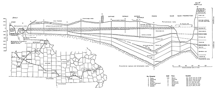
Table 2 shows in descending sequence the Arbuckle formations represented in Missouri, after McCracken (1955), and in eastern Kansas.
Table 2--Formations of Arbuckle age in Missouri and in eastern Kansas
| Missouri* | Eastern Kansas |
|---|---|
| St. Peter sandstone | Rocks of Simpson age |
| Arbuckle group | |
| Early Ordovician | |
| Smithville formation* | Absent |
| Powell dolomite | Absent |
| Cotter dolomite | Undifferentiated Cotter and Jefferson City dolomites |
| Jefferson City dolomite | |
| Roubidoux formation | Roubidoux dolomite |
| Gasconade dolomite | Gasconade dolomite† |
| Late Cambrian | |
| Eminence dolomite | Eminence dolomite† |
| Potosi dolomite | Absent‡ |
| Derby and Doe Run dolomites | Absent‡ |
| Davis formation | Absent‡ |
| Bonneterre dolomite | Bonneterre dolomite |
| Pre-Arbuckle | |
| Lamotte sandstone | Lamotte (Reagan) sandstone |
| * McQueen, 1931, pl. 12. † Present in eastern counties of Kansas but absent in the Salina basin area. ‡ May be present in eastern Kansas (oral communication from Earl McCracken). Absent in the Salina basin area. |
|
Rocks of Late Cambrian Age
Reagan (Lamotte) Sandstone
The Reagan sandstone overlies the Precambrian rocks of Oklahoma and in this respect corresponds to the Lamotte sandstone of Missouri. Both represent a clastic sandy deposit at the base of the Arbuckle group but are not necessarily correlative inasmuch as, in the outcrops, the Reagan underlies the Honey Creek, correlated by Ulrich with the Davis formation of Missouri, and the Lamotte underlies the older Bonneterre dolomite. .Both are basal Upper Cambrian clastic deposits. The basal sandstone of the Central Kansas uplift underlies the Bonneterre dolomite but is commonly called Reagan. Like the Lamotte sandstone of Missouri the basal sediments are generally arkose and grade upward through angular and subangular sandstone into sandy dolomite in the base of the Bonneterre. In central Kansas the arkose is generally referred to as "granite wash," and in some wells its contact with weathered granite in place is obscure. The top of "granite wash" at its contact with the relatively pure overlying sandstone is a more satisfactory datum than the top of the unaltered Precambrian igneous rocks. The contact of the Lamotte or Reagan with the Bonneterre. is placed at the point where dolomite predominates over sand.
In southeastern Missouri the Lamotte has a maximum thickness of 350 feet and thins westward to about 100 feet as the Kansas border is approached. In eastern Kansas it becomes irregularly thinner and in some places is only a few feet thick. It is absent from areas that were topographically high at the time of its deposition. It is also absent from the crest of the Southeast Nebraska arch (from which it was eroded preceding the deposition of the Simpson in that area) and also from parts of the Central Kansas uplift (from which it was removed by pre-Pennsylvanian erosion).
Bonneterre Dolomite
The Bonneterre dolomites of Missouri are typically dark and noncherty, in part interbedded with green shale. The insoluble residues of samples from the top of the formation are generally darkgray or chocolate-colored dolomoldic clay sponge. They grade downward through spongy aggregates of silt and fine sand into angular and sub angular coarse sand at the bottom. Dolomolds in green shale are common in eastern Missouri but not in western Missouri. Glauconite, which is characteristic of the Bonneterre, occurs as fine to coarse granules in the dolomite and in the spongy insoluble residues.
The Bonneterre and the underlying Reagan were widely distributed upon the Precambrian plain except in areas where hills rose above the level of Bonneterre deposition. Such hills are distributed erratically in northeastern Oklahoma, in southeastern Kansas, and on the Central Kansas uplift, where Precambrian quartzite hills in the Kraft-Prusa and adjacent fields in Barton and Ellsworth counties were studied by Walters (1946). Walters effectively described the Precambrian surface, the quartzite hills that rose 225 feet above the plain, and the Arbuckle rocks that overlapped upon their flanks. These hills were originally covered by upper Arbuckle rocks and a long sequence of still younger formations, but after the arching of the Central Kansas uplift that preceded Pennsylvanian deposition, the covering rocks were worn away by erosion and the crests of some of the hills were reexposed.
Among other Precambrian hills capped by Pennsylvanian rocks is one reached by a well in sec. 1, T. 21 S., R. 15 W., reported by the Kansas Sample Log Service. The log of this well reports Pennsylvanian rocks overlying arkose or weathered granite although a nearby well in sec. 31, T. 20 S., R. 14 W., less than a mile distant encountered a normal sequence of Viola, Simpson, and Arbuckle rocks. The Arbuckle in a well about 6 miles west is about 500 feet thick. If the samples from the well in sec. 1 are reliable they indicate that a hill at least 500 feet high rose above the Precambrian plain at this point.
Another Precambrian hill composed of red granite was penetrated by a well in sec. 1, T. 24 S., R. 16 W. Both Lamotte and Bonneterre are missing, but a minimum of 330 feet of younger Arbuckle rocks was eventually deposited across its crest.
The Missouri characteristics of the Bonneterre prevail in southeastern Kansas. Toward the northwest as the areas of the Salina basin and Central Kansas uplift (neither as yet a structural feature) are approached, the fine argillaceous impurities of the lower part give way to fine to medium angular and subangular embedded sand, in some samples amounting to only 1 to 5 percent. Embedded glauconite, especially in Phillips, Rooks, Osborne, and Mitchell counties, identifies these rocks as Bonneterre. Glauconitic dolomite occurs also on the western flank of the Southeast Nebraska arch.
Glauconitic sandy Arbuckle dolomite is preserved in synclinal areas on the Central Kansas uplift notably in sec. 12, T. 11 S., R. 18 W.; sec. 29, T. 11 S., R 17 W.; sec. 5, T. 12 S., R. 17 W.; sec. 32, T. 16 S., R. 14 W.; and sec. 34, T. 16 S., R. 13 W., not far from the Precambrian quartzite hills of the Kraft-Prusa fields. Although not everywhere conspicuously glauconitic, these slightly sandy dolomites at the base of the Arbuckle group seem to be a lateral facies of the more finely clastic (argillaceous and silty) Bonneterre of southeastern Kansas.
The Texas Company No.4 Dees well, in the SE SE NW sec. 23, T. 17 S., R. 9 W., for example, penetrated the Jefferson City-Cotter sequence at a depth of 3200 feet and was drilling in sandy dolomite of probably Roubidoux age at 3435 feet. The actual top of the Roubidoux established by McCracken (1955, p. 53) is slightly higher. Insoluble residues reveal sandy chert at 3455 feet. The Roubidoux continues from this point to 3595 feet, for the insoluble residues of the finely drilled samples consist of 6 to 10 percent mixed chert and sand. The insoluble residues of samples below this point to 3682 feet consist of 2 to 8 percent sand with no chert. Although not seen in the residues, traces of embedded fine particles of glauconite are included in all the untreated dolomite samples from 3610 to 3680 feet. The noncherty beds from 3595 feet to the top of the Lamotte sandstone at 3733 feet are therefore correlated with the similar, more obviously glauconitic Bonneterre dolomites of other wells in the vicinity of the Kraft-Prusa field.
The distinguishing characteristics of rocks that are believed to represent the Bonneterre, in and adjacent to what is now the Salina basin, are absence of chert and presence of minor amounts of medium to fine embedded sand and embedded glauconite, which in some wells occurs in very fine particles very thinly disseminated. Insoluble residues from the Continental No. 1 Boland well in sec. 13, T. 25 S., R. 13 W., farther south include relatively abundant glauconite accompanying and embedded in material that seems to be silicified gray shale.
The Bonneterre, like the Lamotte, was originally deposited on the crest of the Southeast Nebraska arch, from which it was eroded before the deposition of the St. Peter sandstone, and over the Central Kansas uplift, from parts of which it was removed before the deposition of the Pennsylvanian rocks.
McQueen (1931, pl. 1) reports a thickness of 440 feet of Bonneterre in southeastern Missouri. It thins gradually westward, and along the southwestern border of Missouri it is less than 200 feet thick. It continues westward into the Salina basin, where its thickness is 135 to 150 feet. Figure 3 shows gradual convergence, in Missouri, of the Bonneterre and Roubidoux formations, which continues into the Salina basin, where the two formations seem to be in contact. Westward from the central Ozarks the Bonneterre is successively unconformable beneath the Eminence, the Gasconade, and the Roubidoux. In the Salina basin the thickness of the Bonneterre is ordinarily about 150 feet, but in some places pre-Roubidoux erosion reduced the thickness to less than 100 feet. In the Sinclair No.8 Moorehouse well (sec. 4; T. 21 S., R. 3 W.), after correction for about 300 feet of duplication by reverse faulting, the Bonneterre, which is repeated, has a thickness of about 155 feet. Its contact with the Roubidoux in this well is obscure, partly on account of faulting and partly because of the fineness of the samples.
Eminence Dolomite
In central Missouri, the insoluble residues of the Eminence dolomite consist mainly of abundant chert with lacelike dolomolds and thin drusy walls. In eastern Kansas near the Missouri border, very little chert (rarely more than a trace) occurs in the Eminence. The interlocking dolomite crystals are separated by white interstitial films of tripoli. This material is conspicuous in samples but yields only traces of tripolitic flakes and flocculent silica in the insoluble residues. Some of the firmer siliceous flakes reveal fine drusy faces or pittings but form no coherent residues. Both of these types of residue seem to represent the fading out of the very siliceous material characterizing residues from the type locality.
McQueen reports more than 320 feet of Eminence in well 12 (Fig. 3) in south-central Missouri. In well 8 near Carthage, Missouri, he reports 200 feet of Eminence overlying Bonneterre. In well 7, rocks assigned to the Eminence are 160 feet thick and, in the absence of the Potosi, unconformably overlie the Bonneterre and unconformably underlie the Gunter sandstone at the base of the Gasconade formation. In well 6 the Eminence is missing.
McCracken (1955, p. 48) notes that the unconformity previously postulated at the base of the Potosi cannot be supported. From the data now available, it seems possible, as shown in the cross section (Fig. 3), that the Potosi is conformable on the DerbyDoe Run in the subsiding basin in southern Missouri but that the overlying Eminence may overlap unconformably on the underlying Bonneterre toward the west. Current studies of the preRoubidoux formations in Missouri by McCracken may result in revision of the published data and modification of the relations suggested by the cross section.
Prev Page--Introduction || Next Page--Stratigraphy--Ordovician to Silurian
Kansas Geological Survey, Geology
Placed on web Jan. 5, 2017; originally published Dec. 1956.
Comments to webadmin@kgs.ku.edu
The URL for this page is http://www.kgs.ku.edu/Publications/Bulletins/121/03_strat.html