![]()
Prev Page--Structure || Next Page--Bibliography
Oil and Gas
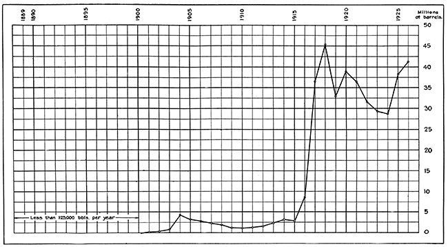
The discovery of oil and gas in Cowley County antedates the advent of Kansas among the leading oil and gas producing states. Kansas has produced oil since shortly after the Civil War, and yet its annual production had never exceeded 5,000,000 barrels until 1916. In that year and the next two, owing to the flush production of the El Dorado, Towanda, and Augusta pools, of Butler County, the output increased with rapid strides. The total in 1918 exceeded 45,000,000 barrels, which constitutes the peak of production to date. Although Cowley County contributed but little to this rapid rise, interest, and activity in the search for oil in the county were coincident with it. A little gas had been found near Winfield as early as 1902, and gas had been discovered at Dexter in 1905. The Dexter gas had attracted wide attention, because it was the first natural gas in which helium had been discovered. A little oil was found near Dexter in 1914; the Peacock oil field, near Winfield, was opened in 1916, and the Clarke pool in 1917. The Winfield district became a large oil producer in 1922, after having been a productive gas field for several years. The Eastman, Rainbow Bend, and Rock Fields, opened in 1923, swelled the county's production in 1924 and really marked the entrance of Cowley County into the group of leading oil-producing counties of the state. Rainbow Bend reached its peak in the summer of 1925, when it produced a daily average of 22,000 barrels for a short time and completed the year with a production of nearly 4,000,000 barrels. The Slick-Carson and Graham fields were opened in 1924 and added nearly 1,500,000 barrels of oil to the county's production in 1925 and nearly 1,000,000 barrels in 1926. The Winfield district had maintained an annual output of about 750,000 barrels for several years prior to the discovery of the State School pool, which added materially to the district's production in 1926 and 1927, bringing the total to nearly 1,250,000 barrels in 1927.
Figure 8--Annual oil production in Kansas, 1889 to 1927.
The annual oil production, in barrels of 42 gallons, of Cowley County compared with the total production of the entire state for the years 1924 to 1927 is given in the following table (data from Oil and Gas Journal). The production of gas has been important for 10 years, but no data are available as to the amounts produced.
| Year | Cowley County | Kansas |
|---|---|---|
| 1924 | 2,266,340 | 29,671,551 |
| 1925 | 7,038,874 | 38,151,622 |
| 1926 | 3,943,061 | 41,346,511 |
| 1927 | 3,303,691 | 41,943,577 |
The place that Cowley County has in the state's oil industry is shown by the drilling activity in the county in the last several years. Largely owing to the impetus furnished by the Rainbow Bend pool, the county was surpassed only by Greenwood County in the number of wells completed and was the leading county in the state in new oil production in 1925; in 1926 Cowley County stood fourth in number of wells completed and fifth in new production; in 1927 Cowley County was third in number of wells completed and fourth in, amount of new production (data from Oil and Gas Journal).
The oil from different parts of the county and different horizons in anyone field varies somewhat in quality, but the bulk of the oil produced is of good grade, ranging in gravity between 37° and 42° Baumé.
A part of Cowley County's oil is refined within her own borders, at refineries in Arkansas City. Refineries at Wichita and Ponca City, Okla., receive a part of the oil. Gasoline is extracted from the gas produced in the Rainbow Bend and Winfield fields. The gas produced in the county is used in part for domestic purposes within the county, but most of it enters the trunk pipe lines. Winfield has recently installed a municipal gas plant in place of one operated for years by the Cities Service Company and is getting its gas supply from wells east of the town.
Oil and Gas Fields
Winfield District
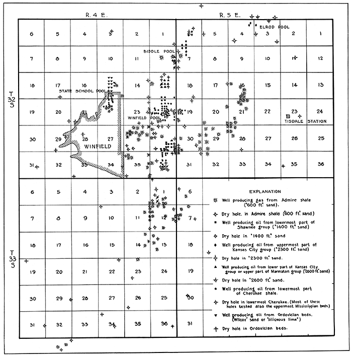
Location--The oil and gas fields here included in the Winfield district are near the town of Winfield, in the west-central part of Cowley County. The district embraces Tps. 32 and 33 S., Rs. 4 and 5 E., and includes the Winfield field proper, the State School, Peacock, Biddle, and Elrod pools, and a number of gas-producing areas east and south of these.
History--Gas was discovered about a quarter of a mile east of Winfield, in the southwest corner of the NW, sec. 26, T. 32 S., R. 4 E., as early as 1902 at a depth of 460 feet, constituting the first discovery of gas west of the Flint Hills (Haworth, 1903, p. 37-88). The cost of the drilling was assumed by the city of Winfield through a bond issue of $15,000 voted for this purpose. The well was reported to yield 125,000 cubic feet of gas. It was not regarded as a commercial producer, and after being drilled to a depth of 1,400 feet it was abandoned. Two other wells, also yielding encouraging shows of gas, were drilled by the city near by (information supplied largely by John H. O'Connor, postmaster of Winfield).
Little information concerning subsequent drilling is available. Meager items, such as dates on log records, indicate that many of the gas wells in the northeastern part of T. 33 S., R. 4 E., were drilled in 1915 and 1916; those in the southeastern part of T. 32 S., R. 4 E., in 1916 and 1917; and those between Tisdale and Winfield several years later. The first commercial oil well was drilled on the George Lierman farm, in the NE, NW, NE, sec. 25, T. 32 S., R. 4 E., where oil was found at a depth of 2,300 feet. The Minnehoma Oil and Gas Company then drilled the McFadden No. 1 well, in the NE, NE, SE, sec. 25, T. 32 S., R. 4 E., but found no oil in the 2,300-foot sand. It was drilled deeper and found oil in the uppermost few feet of the "Mississippi lime (these data furnished by Everett Carpenter, of Bartlesville, Okla.). The exact date of this drilling was not learned, but it was probably about 1915. In 1916 the Peacock field was opened in section 36, with oil at a depth of 1,400 feet (these data furnished by Everett Carpenter, of Bartlesville, Okla.). Dates of later development are mostly unavailable. Some time later the Emerald Oil Company deepened its Kukuk No. 7 well and found oil in the Bartlesville sand, near the base of the Pennsylvanian series (these data furnished by Everett Carpenter, of Bartlesville, Okla.). Still later wells drilled a mile or more to the north found oil at depths of about 2,600 feet in the lower part of the Kansas City group. Oil was being produced in the Biddle pool early in 1922 and in the Elrod pool in 1923. Some of the wells near the center of sec. 6, T. 32 S., R. 5 E., were drilled in 1923, and the State School pool was opened in 1926. Development of parts of the Winfield district is still in progress.
Most of the wells drilled in the Winfield district and their approximate depth are shown by symbols on Figure 9. Although not so indicated on the map, many of the shallow gas wells are now abandoned. Recently a number of additional shallow wells (not shown in Fig. 9) have been drilled to furnish an additional supply to the municipal gas plant. In the heart of the Winfield pool proper from two to four wells are drilled on each location, each well tapping a separate producing sand, but the scale of the map would not permit showing them. Therefore, this part of the map shows many less wells than are actually on the ground.
Figure 9--Oil and gas wells in the Winfield district. [A larger PDF version of this figure is available.]
Stratigraphy--Stratified rocks consisting of interbedded red and gray shale and light-gray limestone of Permian age occupy the surface of the district. Only the limestone beds form conspicuous exposures throughout most of the district; the shale beds, because of their softness, readily weather into soil-covered slopes. The Permian rocks extend beneath the surface for 350 to 450 feet. Interbedded shale and limestone with minor amounts of sandstone of Pennsylvanian age underlie the Permian rocks and constitute a total thickness of about 2,750 feet, although they are thinned somewhat over the crest of the Winfield anticline. The Mississippian limestone ranges in thickness from 225 to 400 feet, and this formation also is thinnest over the crest of the Winfield anticline. Except for a few thin lenses of sandstone and limy shale, it consists entirely of limestone. Beneath the Mississippian limestone is 60 to 70 feet of black Chattanooga shale, underlain by a thick series of Ordovician strata composed of thick beds of siliceous limestone and some shale. One well in this district drilled on the county poor farm in the northeast corner of SE, sec. 34, T. 32 S., R. 4 E., has penetrated the uppermost 700 feet of the Ordovician strata, reaching a total depth of 4,140 feet. Throughout this thickness the strata consist of alternating thick beds of limestone, sandy limestone, and sandstone.
Structure--The accumulation of oil and gas in the Winfield district is in the main controlled by the structural attitude of the stratified rocks, shown in a general way by the contour map (Pl. XI), although the lensing out of the producing sand bodies is in parts of the district equally effective. The oil and gas deposits have accumulated in the higher parts of the anticlinal folds, in porous beds that are extremely lenticular in their occurrence. The most prominent structural feature in the district is the Winfield anticline, which trends slightly east of north through the northeastern part of T. 33 S., R. 4 E., and the southeastern part of T. 32 S., R. 4 E., and thence swings more strongly to the northeast and extends across the northwestern part of T. 32 S., R. 5 E. The Peacock, Winfield, Biddle, and Elrod pools, in T. 32 S., Rs. 4 and 5 E., and the gas pool in the northeastern part of T. 33 S., R. 4 E., are on this fold. A rather pronounced syncline in which there are no oil or gas wells parallels this anticline on the east, and a less pronounced one, separating the Winfield and State School pools, parallels it on the west. The State School pool lies on a gently dipping anticlinal nose in the surface rocks that trends approximately parallel with the Winfield fold. Eastward from the trough of the syncline that borders the Winfield anticline on the east the rocks rise at a fairly uniform rate for several miles to the central part of T. 32 S., R. 5 E., in the area of the gas pools in secs. 16, 21, and 28, where this uniform attitude is slightly interrupted by a gently dipping fold trending southwestward. No doubt many more structural irregularities in this district would be shown by detailed maps of the rock layers that crop out at the surface, but such data are not available for publication at this time.
Peacock pool--Oil and gas have been produced since 1916 in sec. 36, T. 32 S.; R. 4 E., 1 1/2 miles southeast of Winfield, in the area known as the Peacock field. This area is largely depleted, however, as only two or three wells are still producing. Production has been extended northward into the S2, mainly the SE, of sec. 25. Oil is produced chiefly from the "1,400-foot" or Peacock sand, which is a zone in the lower part of the Shawnee group, about 150 feet above the Oread limestone, that contains several relatively thin beds of sandstone with interbedded shale and limestone. Gas was found in no fewer than three sands in the Admire shale at depths ranging between 450 and 700 feet, and wells producing as much as 3,000,000 cubic feet of gas daily were drilled to these shallow sands. Beneath these is a thick water-bearing sand near the base of the Admire. A sandy zone near the middle of the Shawnee group, above the Peacock sand, also yields water. Several sandstone zones beneath the Peacock sand have been penetrated by deep holes at the edge of the producing area. Shows of oil have been found in sands in the Douglas, Lansing, and Kansas City groups. Oil is produced in the northwest corner of the NE SE, sec. 25, from sand near the Kansas City-Marmaton contact, probably in the uppermost part of the Marmaton, struck at a depth of 2,675 feet. A number of deep wells drilled in the edge of the field report thick beds of sandy shale in the Cherokee shale with no indication of oil production from them. One well had a good show of oil from the uppermost part of the Mississippian limestone. The Ordovician rocks yielded water in these deep wells, but as none of them were drilled on the highest part of the fold they do not prove conclusively that the Ordovician beds contain no oil here.
An analysis of oil from the Peacock sand of this field by the United States Bureau of Mines is given below:
| Sample No. 584, Peacock field, Cowley County, Kansas Specific gravity, 0.853; Baumé gravity, 34.1°; sulphur, 0.23 per cent; water, 0.1 per cent; Saybolt Universal viscosity at 70° F., 65.0; at 100° F., 49.2; pour test, 14° F. |
|||||||
|---|---|---|---|---|---|---|---|
| Distillation, Bureau of mines Hempel Method Air distillation; barometer, 738 millimeters. [First drop at 85° C. (185° F.)] |
|||||||
| Temperature | Cut, per cent |
Sum, per cent |
Gravity | Viscosity | Cloud test; deg. F |
||
| Deg. C | Deg. F | Specific | Deg. B | ||||
| 75-100 | 167-212 | 1.0 | 1.0 | 0.737 | 60.0 | ||
| 100-125 | 212-257 | 5.7 | 6.7 | ||||
| 125-150 | 257-302 | 6.0 | 12.7 | .753 | 55.9 | ||
| 150-175 | 302-347 | 6.7 | 10.4 | .773 | 51.1 | ||
| 175-200 | 347-392 | 6.5 | 25.9 | .790 | 47.2 | ||
| 200-225 | 392-437 | 6.7 | 32.6 | .808 | 43.3 | ||
| 225-250 | 437-482 | 6.4 | 39.0 | .820 | 40.7 | ||
| 250-275 | 482-527 | 7.1 | 46.1 | .834 | 37.9 | ||
| Vacuum distillation at 40 millimeters | |||||||
| Up to 200 | Up to 392 | 5.1 | 5.1 | .855 | 33.7 | 41 | 9 |
| 200-225 | 392-437 | 6.1 | 11.2 | .865 | 31.9 | 48 | 32 |
| 225-250 | 437-482 | 6.6 | 17.8 | .874 | 30.2 | 64 | 52 |
| 250-275 | 482-527 | 5.1 | 22.9 | .883 | 28.6 | 94 | 68 |
| 275-300 | 527-572 | 6.3 | 29.2 | .896 | 26.3 | 154 | 86 |
| Carbon residue of residuum, 8.68 per cent. | |||||||
| Approximate summary | |||||||
| Per cent |
Gravity | ||||||
| Specific | Deg. B | ||||||
| Gasoline and naphtha | 25.9 | 0.763 | 53.5 | ||||
| Kerosene | 20.2 | 0.821 | 40.5 | ||||
| Gas oil | 11.2 | 0.860 | 32.8 | ||||
| Light lubricating distillate | 11.7 | 0.878 | 29.5 | ||||
| Medium lubricating diatillate | 6.3 | 0.896 | 26.3 | ||||
Winfield pool--In the Winfield pool proper, centering in the central part of sec. 24, T. 32 S., R. 4 E., gas has been produced from the "600-foot" sand, in the Admire shale; oil and gas from the Peacock or "1,400-foot" sand, in the lower part of the Shawnee group, at depths ranging between 1,400 and 1,500 feet; oil with gas from the "2,300-foot" or Layton sand, in the uppermost part of the Kansas City group, at depths of about 2,300 feet; and much oil with gas from a thick sand in the lowermost part of the Cherokee shale, correlated with the Bartlesville sand of Oklahoma. Ordovician beds have not been tested on the highest part of the fold containing the Winfield pool, but a number of wells drilled in the near vicinity, on the flank of the main anticlinal fold, have found water in the uppermost beds of the Ordovician.
The largest initial production of oil per well was found in the Bartlesville sand, a few wells producing more than 750 barrels a day, and most of them about 200 barrels a day. Initial oil production per well from the "2,300-foot" sand was comparatively small, and that from the "1,400-foot" sand was around 200 to 300 barrels a day. The initial daily production in the shallow gas wells was relatively small, rarely exceeding 2,000,000 cubic feet.
Sands other than those described above as producing bodies have yielded shows of oil or gas in the Winfield pool. In some wells as many as three sands in the Admire shale have yielded gas flows. A thin sand that is present in only a few wells about 150 feet above the horizon of the "1,400-foot" oil sand has produced shows of gas, and a lower sand in about the middle of Douglas group has yielded shows of oil in a few wells. A thick sand that occurs in the uppermost part of the Lansing group as here correlated is widespread in Cowley County and yielded shows of oil in a few wells drilled in the Winfield pool.
There is a gasoline absorption plant in this field. Gasoline is extracted from gas produced with the oil from three sands--the "1,400-foot," the "2,300-foot," and the Bartlesville sand. About one-third to one-half gallon of gasoline is recovered per 1,000 cubic feet of gas handled, and the plant has an average daily run of about 4,000 gallons.
Rockwell pool--Several wells near the center of sec. 13, T. 32 S., R. 4 E., have produced oil from a relatively thin sandstone that occurs a little more than 200 feet beneath the top of the Kansas City group. Throughout most of the productive area, which is small, the producing sand is only about 5 feet thick; nevertheless, the wells have yielded initially a fair amount of oil. The producing wells are listed below:
| Farm | Well No. |
Operating company | Location in sec. 13, T. 32 S., R. 4 E. |
Initial daily production (bbls.) |
|---|---|---|---|---|
| Rockwell | 4 | Marland Oil Co. | Northeast corner SW NE | 595 |
| Rockwell | 3 | Marland & Neely | Northwest corner SW NE | 150 |
| Rockwell | 1 | W. M. Neely Oil Co. | Southwest corner SW NE | 225 |
| Rockwell | 2 | Marland & Neely | Southeast corner SW NE | 130 |
| Spengle | 1 | Sinclair Oil & Gas Co. | Southwest corner SE NW | 625 |
| Newman | 1 | J. A. Hull Co. | Northeast corner NE SW | 260 |
| Cook | 1 | Gypsy Oil Co. | Northwest corner NW SE | 200 |
| Total | 2,185 |
Dry holes have been drilled north, northwest, and southeast of the producers. Most of these dry holes penetrated a thin sand at the horizon of the producing sand, but it failed to yield oil.
Only three of the wells drilled around the center of section 13 produced shows of gas in the Admire shale, although sand bodies in this formation ("600-foot" sand) yield gas abundantly throughout an extensive area in this general region. Very little sand capable of serving as a gas reservoir is recorded in the formation in section 13, which is probably the reason for the absence of gas accumulation. A dry hole near the east edge of section 14, half a mile west of the oil pool and far down the west flank of the fold, shows two thick beds of sand carrying water in the lower part of the Admire shale, and a well near the west quarter corner of section 13 is reported to have yielded a small amount of gas from one of these sands.
Beds of sandstone about 150 feet above the base of the Shawnee group are present throughout the field but yield water; a show of oil is reported from one well. A sandstone bed that ranges between 50 and 160 feet in thickness in the uppermost part of the Lansing group, and throughout the area occurs at a depth of about 1,900 feet, produced a show of oil in three wells and an abundance of water in all wells. The uppermost beds of the Kansas City group, struck at about 2,300 feet, are sandy throughout much of the field and consist of limestone in other parts; several wells reported shows of oil from this horizon but none sufficient for commercial production. These beds produce oil, however, in the central part of section 24, a mile south of this field. The chief producing sand of the field lies a little more than 200 feet beneath the top of the Kansas City group. Four wells in the field have been drilled through the lower beds of the Pennsylvanian and through the Mississippian limestone and Chattanooga shale into the uppermost few feet of the Ordovician rocks. The logs of these wells show, aside from the porous layers described above, a thick bed of water-bearing sandstone near the contact of the Kansas City and Marmaton groups, probably in the upper part of the Marmaton, and sandstone in the lower part of the Cherokee shale; a show of oil from this lower sand was reported in only one well, although oil is obtained from sands at this horizon in the north end of the Winfield pool, less than half a mile south of this field. Porous lenses containing water were reported in the Mississippian limestone. The uppermost few feet of the Ordovician beds, which were encountered at a little less than 3,500 feet beneath the surface, are reported as water-bearing sandstone.
Biddle pool and northeast extension. Somewhat spotted and scattered oil production has been obtained from parts of secs. 6 and 7, T. 32 S., R. 5 E. and the eastern part of sec. 12, T. 32 S., R. 4 E. Several wells have produced a small amount of gas from sands in the Admire shale, struck at depths of about 600 feet. The "2,300-foot" sand, which is a sandy zone near the top of the Kansas City group, yields small amounts of oil in several wells in secs. 6 and 7, T. 32 S., R. 5 E. The "2,600-foot" sand, which occurs near the Kansas City-Marmaton contact, supplies the oil for a few wells of small yield in the eastern part of sec. 12, T. 32 S., R. 4 E. According to the log, one well, in the southwest corner of the NE NW, sec. 7, produces oil from sand struck at a depth of 1,900 feet. Three wells just outside the producing area have been drilled entirely through the Pennsylvanian, Mississippian, and Chattanooga beds into the uppermost Ordovician rocks. According to the logs of these deep wells the lower part of the Cherokee shale contains a large amount of "red rock" in this locality at the general horizon of thick oil-bearing sands of the Winfield pool, 2 miles to the south. The Mississippian and Ordovician rocks that have been penetrated yielded only water in two of these wells, but gave good shows of oil in the Arkansas Fuel Oil Company's Crotsley No. 3 well, in the northwest corner of SW, sec. 7, T. 32 S., R 5 E. The wells drilled in this field are shown on Figure 9.
Elrod pool--A few wells in the northern parts of secs. 3 and 4, T. 32 S., R 5. E., have produced a small amount of oil from the uppermost beds of the Kansas City group. The producing beds are correlated with the "2,300-foot" sand of the Winfield pool but are encountered here at a depth of nearly 2,400 feet. The producing area is small. Several dry holes have been drilled through the "2,300-foot" sand and a little more than 300 feet of beds that lie beneath it. Two dry holes were drilled about a quarter of a mile north of the producers, one half a mile south, one half a mile east, and one a mile southeast. One hole, in the northeast corner of the SW SW, sec. 4, was drilled into the uppermost beds of the Mississippian limestone, which yielded a show of oil. The lower part of the Cherokee shale, which contains oil-bearing sandstone beds in the Winfield pool, consists largely of "red rock" here, according to the log of this well. Another hole was drilled into the uppermost Mississippian rocks in the SE, sec. 34, T. 31 S., R. 5 E., about three-quarters of a mile northeast of the producing wells. The log records a show of oil about the middle of the Kansas City group, no sand in the Cherokee shale, and no shows of oil or gas in the Mississippian limestone.
A sample of the oil from the Elrod pool has been analyzed by the United States Bureau of Mines, with the results shown below.
| Sample No. 585, Elrod field, Cowley County, Kansas Specific gravity, 0.853; Baumé gravity, 34.1°; sulphur, 0.20 per cent; water, none; Saybolt Universal viscosity at 70° F., 65.6; at 100° F., 49.8; pour test, 5° F. |
|||||||
|---|---|---|---|---|---|---|---|
| Distillation, Bureau of mines Hempel Method Air distillation; barometer, 737 mm. [First drop, 54° C. (129° F.)] |
|||||||
| Temperature | Cut, per cent |
Sum, per cent |
Gravity | Viscosity | Cloud test; deg. F |
||
| Deg. C | Deg. F | Specific | Deg. B | ||||
| 75-100 | 167-212 | 4.1 | 4.1 | 0.701 | 69.7 | ||
| 100-125 | 212-257 | 5.5 | 9.6 | .734 | 60.7 | ||
| 125-150 | 257-302 | 5.2 | 14.8 | .754 | 55.7 | ||
| 150-175 | 302-347 | 5.8 | 20.6 | .773 | 51.1 | ||
| 175-200 | 347-392 | 5.3 | 25.9 | .790 | 47.2 | ||
| 200-225 | 392-437 | 5.9 | 31.8 | .806 | 43.7 | ||
| 225-250 | 437-482 | 6.2 | 38.0 | .820 | 40.7 | ||
| 250-275 | 482-527 | 6.5 | 44.5 | .834 | 37.9 | ||
| Vacuum distillation at .10 mm | |||||||
| Up to 200 | Up to 392 | 5.3 | 5.3 | 0.855 | 33.7 | 40 | 16 |
| 200-225 | 392-437 | 5.9 | 11.2 | .861 | 32.6 | 47 | 30 |
| 225-250 | 437-482 | 5.7 | 16.9 | .873 | 30.4 | 62 | 48 |
| 250-275 | 482-527 | 5.2 | 22.1 | .884 | 28.4 | 93 | 61 |
| 275-300 | 527-572 | 6.7 | 28.8 | .897 | 26.1 | 160 | 79 |
| Carbon residue of residuum, 7.4 per cent | |||||||
| Approximate summary | |||||||
| Per cent |
Gravity | ||||||
| Specific | Deg. B | ||||||
| Gasoline and naphtha | 25.9 | 0.753 | 55.9 | ||||
| Kerosene distillate | 18.6 | 0.820 | 40.7 | ||||
| Gas oil | 11.2 | 0.858 | 33.2 | ||||
| Light lubricating distillate | 10.9 | 0.878 | 29.5 | ||||
| Medium lubricating distillate | 6.7 | 0.897 | 26.1 | ||||
Shallow gas fields--Relatively thin lenticular sands in the Admire shale of the Wabaunsee group yield gas throughout an extensive area in the Winfield district. Because these sand lenses occur about 600 feet beneath the surface throughout much of the district this gas-producing zone is known as the "600-foot" sand. Parts of the area were drilled as early as 1906, and the gas from this horizon supplied much of the gas used for domestic purposes in this region for many years. Much of the gas of the drilled area is now depleted, but other parts are still producing, and additional wells are being drilled.
The wells in the south-central part of section 16 and north-central part of sec. 21, T. 32 S., R. 5 E., about 2 miles northwest of Tisdale, yielded initial gas flows ranging from 1,000,000 to 3,250,000 cubic feet a day, with rock pressures of 170 to 250 pounds to the square inch. The initial daily production of the wells surrounding the corner common to secs. 20,21, 28, and 29, T. 32 S., R. 5 E., ranged from a little less than 1,000,000 to 3,000,000 cubic feet, with rock pressures of 250 to 280 pounds to the square inch. The wells in the western part of section 29 and eastern part of sec. 30, T. 32 S., R. 5 E., yielded from 250,000 to 2,000,000 cubic feet of gas each, under a rock pressure of about 260 pounds to the square inch. The wells in the southwestern part of section 30 yielded as much as 3,250,000 cubic feet a day. Little information is available concerning the gas wells immediately east of Winfield. The meager data at hand indicate that several wells had an initial daily gas production of about 2,250,000 cubic feet. Many of the wells drilled in the area surrounding the corner common to secs. 1, 2, 11, and 12, T. 33 S., R. 4 E., yielded less than 1,000,000 cubic feet of gas daily, but a few wells are reported to have exceeded this amount. Initial production of less than 500,000 cubic feet each was obtained from the wells in secs. 13 and 14, T. 33 S., R. 4 E. The rock pressures reached 265 pounds to the square inch. The wells in the eastern part of section 12 yielded less than 1,000,000 cubic feet each. Other localities in this region, a few of which are the Winfield pool, the Biddle pool, and sec. 5, T. 34 S., R. 4 E., have furnished gas from the "600-foot" sand in amounts comparable to those from the wells above mentioned.
The gas from the Winfield district contains helium in greater amount than the average content of natural gas. An analysis of a pipe-line sample taken in 1918 showed a helium content of 0.38 per cent, gas from a well 5 miles northeast of Winfield contained 0.813 per cent, and gas from a well 3 miles east of Winfield contained 0.34 per cent, according to analyses made by Dr. H. P. Cady, of the State University (Rogers, 1921, p. 100, 101).
In a general way the gas accumulation of this district is controlled by the structural attitude of the strata. The largest yields are found in the highest parts of the folds; some gas in sands found at shallow depths extends far out on the flanks--in fact, much farther than the oil and gas of the deeper-lying producing sands; no gas is found in the lowest parts of the broad synclines that lie between the anticlinal folds. The gas wells in secs. 16, 21, 28 and 29, T. 32 S., R. 5 E., are on a broad, gently flexed fold that trends southwestward. The gas and oil fields that lie near the line between R. 4 E. and R. 5 E. are on an extensive fold that trends slightly east of north throughout much of the region and swings northeastward across the northwestern part of T. 32 S., R. 5 E. This anticlinal fold broadens out in sec. 26, T. 32 S., R. 4 E., a fact which may account for the extreme width of the gas-producing area there. If the axial line of the southwestward-trending fold that extends through the central part of T. 32 S., R. 5 E., and contains the gas pools of secs. 16, 21, 28 and 29 is projected it will intersect the fold containing the Winfield pool at the locality of the gas wells in the northeastern part of T. 38 S., R. 4 E. It may be that the coalescing of these two gently dipping folds has formed a broad dome-shaped flexure in this locality, thus accounting for the wide distribution of the gas production there.
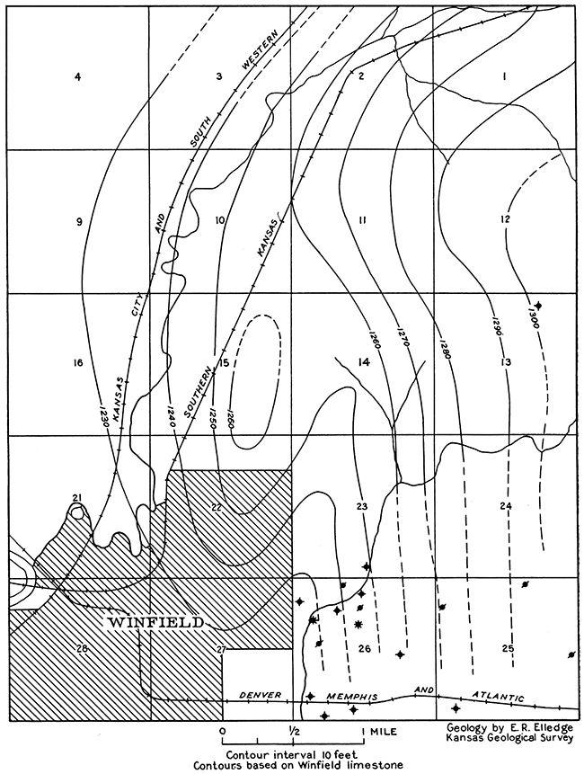
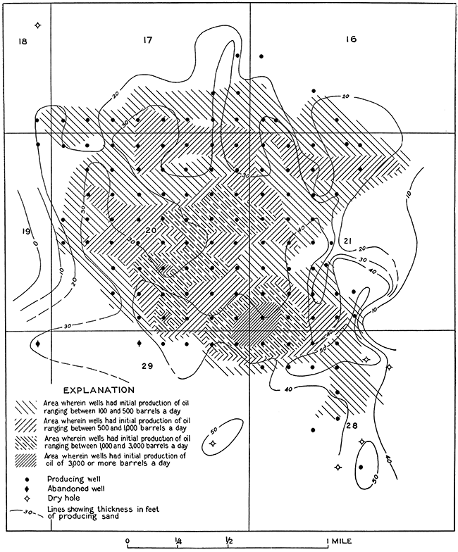
State School pool--The most recently opened pool in the vicinity of Winfield is the State School pool, in part within and in part just north of the northeastern part of the town. . Most of the oil is produced from the uppermost Ordovician beds, from wells surrounding the center of sec. 15, T. 32 S., R. 4 E. The discovery well, on state land in the northwest corner of the SE, sec. 15, located by the State Geological Survey of Kansas and drilled by the J. A. Hull Oil Company, had an initial production from this horizon of nearly 12,000 barrels of oil a day. Most of the wells producing oil from this horizon quickly settle from an early flush production to a relatively small daily yield of oil and considerable water. The settled production of the west offset to the discovery well was 160 barrels a day; that of the north offset about 400 barrels; and the east offset, although having a initial production of 600 barrels, soon settled to a production of 30 barrels of oil and 60 barrels of water. Wells farther north of the discovery well have maintained a higher settled yield, however. The wells are pumped by means of gas forced into the oil sand under pressure, the gas being obtained in the field from shallower sands. Production from the Ordovician beds has not extended far south of the discovery well, but sands found at shallower depth have proved productive there. The chief production from shallow beds is obtained from a sandstone in the uppermost part of the Kansas City group, struck at a depth of about 2,300 feet. It yields gas and oil. It is production from this sand that has extended the field southward within the city limits of Winfield. A few wells obtain oil and gas at a depth of about 2,500 to 2,600 feet from a sandy zone that is near the contact of the Kansas City and Marmaton groups.
The attitude of the surface rocks in the State School field is shown in Figure 10, made by E. R. Elledge for the Kansas Geological Survey. Structure contours were drawn on a single layer or bed of rock, the Winfield limestone, on the basis of a detailed plane-table survey of the area. The rocks have a regional dip to the west, with a local southwestward nosing.
Figure 10--Structure contour map of the surface beds in the State School field, mapped by E. R. Elledge in August, 1920.
Rainbow Bend Field
Location--The Rainbow Bend field is in the extreme western part of Cowley County, in the western part of T. 33 S. R. 3 E., and the western extension of the field extends across the county boundary into Sumner County. The main part of the field lies within a great bend of Arkansas river, from which the name of the field is derived.
History of development and production--On November 28, 1923, a well being drilled in the northwest corner of the SE, sec. 20, T. 33 S., R. 3 E., on the Johnson farm, came in as a flowing oil well with an initial daily production of 337 barrels from sand struck at a depth of 3,198 feet. It is of interest that the original contract for drilling this well specified a total depth of 3,000 feet; an additional 198 feet discovered Cowley County's richest oil pool. The acreage block for the test had been assembled and a favorable report based on a geologic survey of the surface had been made by M. W. Baden, of Winfield, prior to the drilling of the well.
This field has been systematically developed because it is owned jointly by only three operating oil companies. The Independent Oil and Gas Company and the Waite-Phillips Company originally owned the entire field. Later the Marland Oil Company purchased one-half of the Independent's half interest and the Waite-Phillips Company was purchased by the Barnsdall Oil Company. At present the field is owned by the Barnsdall Oil Company, one-half interest; the Independent Oil and Gas Company, one-fourth; and the Marland Oil Company, one-fourth. The discovery well came in late in 1923; 18 wells were drilled in 1924, about 100 in 1925, and 10 in 1926.
The wells drilled in 1924 had an average initial production of 995 barrels of oil a day; those drilled in 1925 averaged 700 barrels, and those in 1926 less than 100 barrels. Practically all the wells drilled in 1926 were near the edge of the pool, as were also many of those drilled in 1925, although in 1925 the bringing in of a number of wells with initial yields greater than 2,000 barrels it day largely offset the adverse effect of small edge wells on the average. The initial daily production of the wells has been as high as 3,624 barrels, this amount being obtained by the T. Snyder No. 2 well, in the northwest corner of the SW SW, sec. 21. Although the discovery well is near the center of the producing area, each offset to it had a much greater initial production than it, the amounts ranging from 637 barrels, made by the Charles Glasgow No. 1, the west offset, to 3,000 barrels, made by the L. Johnson No. 3, the south offset. The north offset made 1,906 barrels, and the east offset 900 barrels. The peak production of the field was reached in the summer of 1925, a year and a half after the bringing in of the discovery well, when a little more than 20,000 barrels of oil a day was produced. In June, 1927, the field was making a little less than 2,000 barrels of oil a day from 125 producing wells. It was also producing 4,000,000 cubic feet of gas a day, from which 8,500 gallons of casing-head gasoline was extracted. None of the gas was being returned to the oil sand, and it was stated by representatives of the operating companies that they felt confident the oil production could be more than doubled by returning gas to the sand, thus restoring in part the original rock pressure. The field has produced to date (June, 1927) a total of more than 8,500,000 barrels of 410 oil. The total production of gas and casing-head gasoline was not learned.
The peak of gas production was reached in June or July, 1925, when a daily production of 112,000,000 cubic feet was maintained. The gasoline content at that time was 1.5 to 1.6 gallons per 1,000 cubic feet of gas. [Production figures supplied by R. B. Rutledge, of Barnsdall Oil Company.]
Surface rocks--As shown on the county geologic map (Pl. I), most of the surface of the Rainbow Bend field is occupied by alluvium of the Arkansas river valley. The remainder of the field and an extensive surrounding region is underlain at the surface by the lower part of the Wellington formation, which is composed of soft shale and contains, except in small areas, scarcely any hard beds that crop out in sufficient prominence to serve as key beds for structural mapping. Throughout most of the area of outcrop of the Wellington formation the surface is a gently undulating soil-covered plain containing few bedrock outcrops. A bed of cavernous limestone about 3 feet thick crops out in secs. 7, 17 and 20, T. 33 S., R. 3. E. The exact stratigraphic position of this bed is not known, but it may be a bed of limestone and gypsum that is recorded in numerous core-drill logs in the vicinity, occurring about 50 feet above the base of the Wellington. On the basis of well-log correlations it appears probable that the Herington limestone and perhaps even the uppermost part of the Enterprise shale have been removed by erosion from the structurally highest areas in parts of section 17.
Buried rocks--Most of the formations that crop out in Cowley County eastward from the Rainbow Bend field can be recognized in the logs of wells drilled in the field. The log of the Waite Phillips-H. Thurlow No. 7 well, in the SE, sec. 17, T. 33 S., R. 3 E., records the following formations, which crop out within Cowley County:
The alluvium of Arkansas river valley is reported as being 53 feet thick, which is a representative thickness for much of the bottom land bordering the river. The Winfield limestone is believed to have been encountered at a depth of 100 feet, the Fort Riley limestone at 200 feet, the Wreford limestone at 245 feet, the Crouse limestone at 345 feet, the Cottonwood limestone at 515 feet, the Neva limestone at 565 feet, the Red Eagle limestone at 618 feet, the Foraker limestone at 655 to 705 feet. The Admire shale, Emporia (?) limestone, and Willard (?) shale extend to a depth of 1,015 feet, where two thin beds of limestone that may be the Burlingame limestone were struck. The sandstone between depths of 980 and 1,000 feet appears to be at the horizon of the sandstone in the Willard shale that is so well exposed in the town of Cedarvale, a few miles east of Cowley County.
Several thin beds of sandstone were encountered in the wells of the Rainbow Bend field above a depth of 2,000 feet, but none produced even shows of oil or gas. The sand in the uppermost part of the Lansing group, which is so productive a few miles north of the field, in the Churchill pool of Sumner County, and in and directly south of the town of Oxford, was encountered at depths of about 2,200 feet in the Rainbow Bend field, but produced only water. The uppermost part of the Kansas City group lies about 2,600 feet beneath the surface in the Rainbow Bend field and gave very good shows of oil--as much as 25 barrels. No commercial production is obtained from this sand, however, in the Rainbow Bend pool, although it produces about a mile to the northeast, in the Graham pool, and elsewhere in Cowley County. Snow and Dean have correlated this sand with the Layton sand of Oklahoma and the Stokes sand of the El Dorado field (Snow and Dean, 1925, p. 974-982). The only sand that produces oil or gas in the Rainbow Bend field is found near the base of the Pennsylvanian series lying directly upon the Mississippian limestone or separated from it by a relatively thin veneer of chert derived from the limestone by erosion in early Pennsylvanian time. This sandstone appears to be a sand lens of more or less circular shape, thinning and disappearing toward the west, north and east and having a lobe-like projection toward the southeast. The sand has been called the Rainbow Bend sand and has been correlated by Snow and Dean with the Burbank sand of the Burbank field of Oklahoma (Snow and Dean, 1925, p. 980). These authors state that a cross section from Burbank to Rainbow Bend shows that this sand in the Oklahoma field is separated from the Mississippian limestone by an appreciable thickness of shale. The shale body thins northward to entire disappearance, and so in Kansas the sand lies directly upon the Mississippi limestone. According to Rutledge both the Rainbow Bend sand and the Burbank sand are now commonly assigned by geologists of this region to "the Bartlesville sand horizon" (R. B. Rutledge, personal communication). It is recognized that the name Bartlesville as applied here and in numerous other localities in Kansas does not imply that the sand is continuous or necessarily contemporaneous in deposition with the Bartlesville sand at the type locality, Bartlesville, Okla. The name is applied to a zone in the lower part of the Cherokee shale that contains lenticular sand bodies in many localities throughout eastern Kansas and northern Oklahoma. In many places the sands are separated from the "Mississippi lime" by a shale unit that reaches a thickness of 200 feet but is commonly less than 100 feet thick. In several localities, however, the sand lies directly upon the Mississippian surface, as it does in the Rainbow Bend field. The sand body in the Rainbow Bend field is composed largely of angular to subrounded quartz grains, in general rather poorly sorted, and contains, at least in parts of the field, a considerable percentage of clay. The sand grains are held together by clay and calcareous cement and in part by siliceous cement. The log of the Phillips well, on the east bank of Arkansas river in the NE, sec. 28, reports coal in the upper half of the sand body. Throughout the entire field, except in the extreme southeastern part, the sand body is devoid of any appreciable amount of water. Wells are usually drilled entirely through the sand and a few feet into the underlying "chat," or into the Mississippian limestone if "chat" is not present. Water is encountered only a few feet beneath the upper surface of the limestone.
Structure--The contour map (Fig. 11) shows the attitude of the upper surface of the "Mississippi lime" in the Rainbow Bend field. The producing wells are on the southeast flank of a "high" whose crest must lie at some point northwest of the pool. The producing sand body thins northwestward and is probably absent in the higher parts of the fold. Recently oil has been found in Pre-Mississippian beds that lie structurally high near the east quarter corner of section 7, about 1 1/2 miles northwest of the Rainbow Bend field, but the detailed structural relationship between the two areas is not yet known.
Figure 11--Contour map showing altitude of the top of the "Mississippian lime" in the Rainbow Bend field, T. 33 S., R. 3 E. [A larger PDF version of this figure is available.]
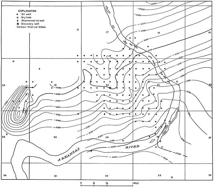
Occurrence of the oil and gas--The largest yields are obtained well down on the southeast flank of the dome, some in an area surrounding the corner common to sections 20, 21, 28 and 29 and others in the south-central part of section 20. Figure 12 was prepared in an effort to determine if there is a definite relation between amounts of oil production and the total thickness of the sand body. It appears from this study that the total thickness of the sand does not absolutely control the initial production of the wells. The thickest part of the sand body occurs in the north-central part of section 28 and extends into section 21, where it is a little more than 50 feet thick, but the initial production of the wells in this area ranged from less than 100 barrels to 500 barrels, whereas the producing sand body of a 3,000-barrel well in NW SE, sec. 20, is only 23 feet thick. The wells near the corner common to sections 20, 21, 28 and 29 had initial production above 3,000 barrels, but sand thicknesses averaging about 43 feet. However, the total thickness of the sand cannot be said to have no effect upon the initial production of the wells, because none of the very large producers occur where the sand is excessively thin, but all occur where the sand body has an appreciable thickness, and some small wells occur where the sand is comparatively thick. Rutledge and Snow, who have followed closely the development in this field, state that the controlling factors in amount of production are the porosity and thickness of the producing part of the sand (R. B. Rutledge and D. R. Snow, personal communication). They state that wells such as those in the NE of section 29, which show a large total thickness of the sand body but had a very small initial production, were drilled into a very hard sand that is extremely "tight"--that is, very closely cemented. According to these geologists it is only in the southeastern part of the field that edge water controls production; elsewhere toward the edge of the pool either the thinning of the sand practically to disappearance or increased cementation of the sand bringing about a low porosity, determine the limits of the producing area.
Figure 12--Relation between initial production and thickness of producing sand in the Rainbow Bend field, T. 33 S., R. 3 E.
Graham Field
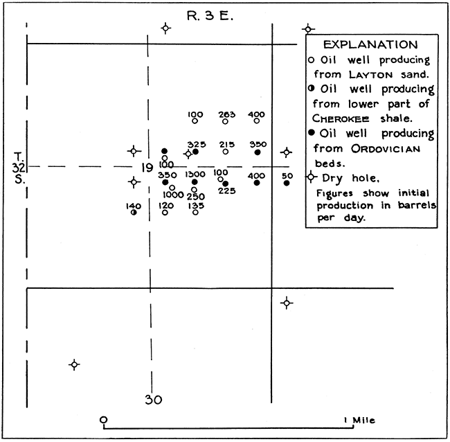
Location--The Graham field is in the western part of Cowley County about a mile northeast of the Rainbow Bend field, in secs. 3, 9 and 10, T. 33 S., R. 3 E.
History of development and production--The Graham pool was discovered by the Marland Oil Company on August 1, 1924, when that company drilled W. Graham well No. 1, in the northeast corner of section 9, into Ordovician (?) beds, which were struck at a depth of 3,518 feet. The well had an initial daily production of 1,000 barrels. The location was staked on the basis of the presence of a dome-shaped uplift in the near-surface rocks disclosed by core drilling. The largest well in this field was the Marland Oil Company's J. A. Bower No. 4, on the crest of the dome, which had an initial production of 3,600 barrels of oil a day from depths of 3,484 to 3,492 feet. Only oil is produced in the field, although good shows of gas were encountered in many wells. Thirty-eight wells have been drilled in the field. Three were drilled in 1924, and the remainder in 1925. Four of them are twin wells drilled only to the shallow sand and located directly beside wells to the deep "pay." In all, 21 wells were completed as producers from Ordovician (?) beds and 12 were completed as producers from the shallower Layton sand. Four wells were completed as dry holes after testing the shallow and deep horizons. One well, the G. T. Wright No. 4, near the center of the pool, was completed as a dry hole after testing only the shallow horizon.
The field was defined and drilled by the end of 1925. There are at present 32 producing wells in the field. The greatest amount of oil has come from the Ordovician (?) beds, the production from the Layton sand amounting to only a small percentage of the total. The oil has a gravity of 42° Baumé, The total production of the pool to June 1, 1927, was about 1,500,000 barrels of oil, and the daily production at that time about 600 barrels (Estimated from known total for 20 wells).
Stratigraphy--The surface of the Graham field is occupied by wind-blown sand and soil concealing the lowermost beds of the Wellington formation. The correlation of well logs leads to the belief that the Herington limestone is but a few feet beneath the surface over the crest of the dome, near the center of the field. Wells drilled in this field accordingly start near the top of the vertical section of rocks given on Plate I and penetrate the entire series in the first 1,000 feet of depth. These rocks, which crop out farther east in Cowley County, are for the most part readily recognizable in the logs of the wells drilled in the Graham pool. For example, in the log of the J. A. Bower No. 4 well, in the NW, sec. 10, on the crest of the dome, the "sandstone" reported at depths of 35 to 40 feet is believed to be the Herington limestone; the Winfield limestone is thought to have been struck at 95 feet, the Fort Riley limestone at 200 feet, the Wreford limestone, reported as sandstone, at 365 feet, the Cottonwood limestone at 500 feet, the Foraker limestone at 640 to 695 feet, and the Burlingame limestone at a little beneath 1,000 feet. Wells near the crest of the dome penetrated the lowermost 500 feet of the Permian rocks, 2,700 feet of Pennsylvanian beds, about 240 feet of "Mississippi lime," about 80 feet of Chattanooga shale, and from 2 to 10 feet of limestone of Ordovician (?) age. A regional correlation of these rocks is shown in the correlation table (Pl. II).
Oil-producing rocks--Beds at two widely separated horizons yield oil in the Graham field, the more productive zone being the uppermost few feet of limestone of Ordovician (?) age, encountered at depths averaging about 3,500 feet. Some oil is produced also from a sandy zone in the uppermost part of the Kansas City group, of Pennsylvanian age, encountered at depths averaging about 2,550 feet. This upper zone has been correlated by Snow and Dean with the Layton sand of Oklahoma and the Stokes sand of the El Dorado field (Snow and Dean, 1925, p. 978). The production from the shallow sand has been relatively slight, although 13 wells are producing oil from this sand. According to the logs, the Rainbow Bend sand, which lies at the base of the Pennsylvanian series and is so productive of oil a mile to the southwest, in the Rainbow Bend field, is present with a wide range in thickness and irregular distribution in the Graham field. A number of wells in the SE and the N2 NE, sec. 9, and the N2 SW and the N2 NW, sec. 10, record sand at this horizon, but logs of wells near the center of sec. 10 and some of the wells in the NW, sec. 10, and the NE, sec. 9, show no sand (R. B. Rutledge, personal communication). Most wells found good shows of gas at this horizon, one well reporting 5,000,000 cubic feet; others had a show of oil, but no commercial production of either oil or gas is obtained. [According to Rutledge, the material reported as sand is in most places "chat" lying on the "Mississippi lime" and does not represent the Rainbow Bend sand.] A show of gas was found in a thin sand near the middle of the Shawnee group in one well, the Bower No. 3 of the Marland Oil Company, in the southeast corner of the SE NW, sec. 10. A sand body of irregular thickness, the maximum being 150 feet, occurring in the lower part of the Shawnee group, produced a "hole full of water" in most wells. Sand in the upper part of the Lansing group is also as much as 150 feet thick in the Graham field and yielded similar results.
Structure--The attitude of the rocks in the Graham field and the surrounding area cannot be determined from observation of the surface beds, because of the absence of outcrops of beds that can be traced throughout any appreciable area. The bedrock is concealed beneath a mantle of wind-blown sand and soil. The domed attitude of the beds was discovered by the sinking of systematically spaced core-drill holes to a sufficient depth to penetrate a recognizable layer of rock, usually referred to as a key bed, which in this region is the Herington limestone. On the basis of data thus procured a definite domed structure was outlined on the Herington limestone, although the amount of dip away from the crest of the dome as reflected by this formation is less than that of deeper strata determined by later deep drilling when the field was developed for oil. The upper surface of the Mississippian limestone is shown in Figure 13 by contour lines, drawn by geologists of the Marland Oil Company on the basis of data obtained from wells drilled in the field. This map does not represent the true attitude of the Mississippian beds, however, because a considerable thickness of its uppermost part was eroded prior to its burial by the present overlying beds. The contour lines of Figure 13 then actually represent the present configuration of this old erosion surface in the Mississippian limestone.
Figure 13--Contour map of the top of the "Mississippi lime" in the Graham field, T. 33 S., R. 3 E.
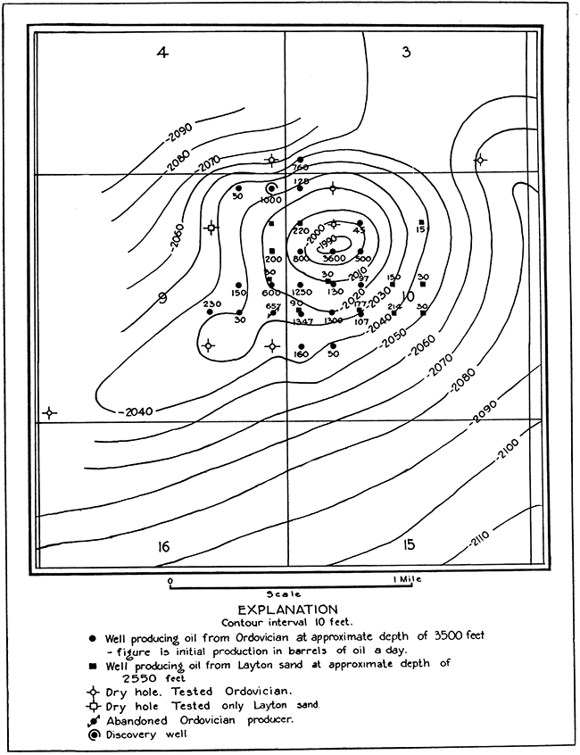
The limestone unit is thinner over the crest of the fold than low on the flank, varying in thickness as much as 90 feet in three-quarters of a mile. If a uniform thickness were assumed for the Mississippian limestone the structure would accordingly show steeper dips than those shown in Figure 13. A structure map similar to Figure 13 but drawn on the top of the Ordovician strata, which lie about 350 feet below the top of the Mississippian limestone, shows very much steeper dips in these beds on the north and northwest flanks of the dome but conforms closely to the attitude of the Mississippian surface on the south flank.
Slick-Carson Field
Location--The Slick-Carson field is near the center of the west side of Cowley County, about 3 miles southeast of Oxford, in sees, 19 and 20, T. 32 S., R. 3 E. The field is small, occupying only a small part of section 19 and a few acres in section 20.
History and production--Oil was discovered in sec. 19, T. 32 S., R. 3 E., in the Carson No. 1 well, drilled by T. B. Slick, in October, 1924. Most of the other wells of the field were drilled in 1925 and 1926. The oil is produced chiefly from beds at two horizons separated by 800 feet of strata, and so twin wells have been drilled throughout the main part of the pool, one set of wells being drilled to depths of 2,600 to 2,700 feet and the other to about 3,450 feet. Eight producers and seven dry holes have been drilled to the deeper sand in and near the field, and ten producers have been drilled to the shallow sand. According to information obtained from well logs, the initial daily production of wells producing from the deeper sand has been as much as 1,300 barrels of oil, but averaged about 400 barrels; that of wells producing from the shallow sand has been as much as 1,000 barrels and averaged about 275 barrels. One well produced oil from sand in the lowermost part of the Cherokee shale, about midway in depth between the deep and shallow sands. Its initial production was 140 barrels of oil a day. The wells of the field are shown in Figure 14.
Figure 14--Map of Slick-Carson field, T. 32 S., R. 3 E.
Surface rocks--The surface of the Slick-Carson field is occupied by Recent alluvium of the Arkansas river valley, which completely mantles the bedded Permian rocks that lie 40 feet, more or less, beneath the surface. It is impossible to determine the attitude of the bedded rocks that are involved in the folding of the region from a study of the surface, because the alluvium is of Recent age and was spread over the area long after the Permian and deeper-lying rocks were folded. In such an area the attitude of the buried rocks is determined by core drilling through the alluvium to a definitely recognizable key bed in the underlying rocks.
Buried rocks--Few of the individual limestone beds and formations seen at their outcrops farther east in Cowley County can be recognized in the logs of wells drilled in this field, but the several groups of strata can be fairly satisfactorily determined by well-log correlation. The lowermost part of the Wellington formation immediately underlies the alluvium, which is 30 to 40 feet thick in this area. The Herington limestone is believed to be a little less than 100 feet beneath the surface. The red bed encountered at depths of about 100 to 110 feet is believed to be in the upper part of the Doyle shale, and the limestone above it to be the Winfield limestone and the Luta limestone. The red beds reported at depths of about 350 feet are thought to be in the Matfield shale, and the limestone beds above them to be the uppermost part of the Matfield, the Florence flint, and the Fort Riley limestone. The persistent red bed struck at 400 to 420 feet is probably in the uppermost part of the Garrison shale, and the limestone above it is the Wreford limestone. The Neva limestone is encountered beneath a red shale at a depth of about 600 feet. The upper half of the Wabaunsee group is reported in most logs as chiefly limestone with thin beds of shale. The lower half is largely shale. Thin sandstone lenses occur in the lower part of the group, and limestone beds are reported near what is assumed to be the base, at a depth of about 1,000 feet. The Shawnee group extends from this depth to about 1,800 feet and consists of alternately bedded limestone and shale. Water-bearing sandy zones occur near the top and near the base. The Douglas and Lansing groups combined extend to a depth of a little greater than 2,500 feet and are made up chiefly of shale; thin beds of limestone are prevalent in the uppermost part, and a thick water-bearing sandstone occurs near the middle, probably near the contact of the two groups. The Kansas City and Marmaton groups, composed largely of limestone, occupy the underlying interval to a depth of about 3,000 feet. The upper part of the Kansas City group contains thick beds of sandstone that constitute one of the two chief oil-producing zones of the field. The Cherokee shale, with a thickness of 115 to 120 feet, underlies the Marmaton group and is composed almost entirely of shale. A thin bed of sandstone occurs near the base of the Cherokee in wells surrounding the center of section 19. The Mississippian limestone is logged in most wells as a solid unit of limestone averaging about 230 feet in thickness; it is thinnest in the central part of the field. Beneath it is 75 feet, more or less, of black shale called the Chattanooga shale. A thin sandstone is present in most wells beneath the Chattanooga shale. Where this sandstone is absent the drill goes directly into limestone, at a depth of a little more than 3,400 feet. One well was drilled 400 feet below the base of the Chattanooga shale, penetrating alternately bedded sandy limestone and limestone beds with two beds of sandstone in the uppermost 100 feet.
Possible oil-producing rocks--Thin sandstone beds in the lower half of the Wabaunsee group have yielded gas in parts of Cowley County, These beds were reported in about half of the wells in this field, but only one well yielded a show of gas. Water was reported in the remaining wells. Nearly all wells reported sandstone in the upper part. of the Shawnee group and another sandy zone in the lower part. The upper zone yielded a show of oil in one well, a show of gas in two wells, and water. in almost all others-many of them a "hole full of water." The lower zone produced only water. A thick sandstone unit that occurs near the Douglas-Lansing contact, herein correlated with the uppermost part of the Lansing group, yielded an abundance of water in practically all wells except one, which had a show of oil with water at this horizon.
A zone a few feet below the top of the Kansas City group, about 2,600 feet beneath the surface, is recorded in most well logs as sandstone, in others as limestone and sandstone or sandy shale, and in a few as sandy limestone. It carries oil throughout most of the field and is the chief shallow producer. In part of the area a sandy zone is present about 75 feet beneath this one. It produced oil in one well, gave shows of oil and gas in others, and yielded water in most wells. No sands occur in the Marmaton group, and no shows of oil or gas were reported from it. Shows of oil were reported from sand near the base of the Cherokee shale in three wells near the center of section 19, and oil is produced from this sand in one of these wells in the southeast corner of NE SW. Southwest of the field, just west of the county boundary, in the northeast corner of the SE SE, sec. 24, T. 32 S., R. 2 E., Sumner County, a small oil production is obtained from this sand. No sands or shows of oil or gas were reported from the Mississippian limestone. One well reported a thin layer of "chat" on top of the limestone, which yielded a small show of oil. A thin sand lying immediately beneath the Chattanooga shale produces oil throughout most of the field; some wells produce oil from porous limestone found at this horizon where the sand is absent. It is not known whether the sand is the Misener, the "Wilcox," or some other part of the Ordovician, or whether the porous limestone is part of the Simpson or the Arbuckle limestone.
Structure--In the Slick-Carson field the bedded rocks that lie beneath the alluvium of the Arkansas river valley have a domed attitude. A study of well records indicates that the departure from horizontality is only slight, however, in the near-surface beds but becomes greater with depth. The oil production is confined to the higher parts of the dome. Structure-contour maps of several horizons in the field are shown in Figure 7.
Smith-Shafer Pool
Location--The Smith-Shafer pool is about 2 miles southeast of Udall, in the northwestern part of the county. The producing wells are confined to the E2, sec. 10, T. 31 S., R. 3 E.; two dry holes immediately east of the producers have been drilled in section 11.
History and production--Oil was discovered in this field in 1917. Thirteen wells have been drilled; all but three were completed as oil producers, one of which has since been abandoned. The oil is produced from the Bartlesville sand, which lies at a depth of about 3,050 feet. No appreciable amount of gas was found, and the daily oil production is relatively small, but the wells are comparatively long-lived. In June, 1927, the field was making about 200 barrels of oil a day from nine wells.
Surface and buried rocks--The greater part of the surface of the Smith-Shafer field is occupied by the lower part of the Wellington formation; the Herington limestone and Enterprise shale occupy the northeastern part of the field. The rocks of Permian age extend to a depth a little greater than 400 feet; next below are the Pennsylvanian beds, with an aggregate thickness of about 2,660 feet, consisting of alternate layers of limestone and shale with a relatively few beds of sandstone. Unlike the strata of the gas-producing region near Winfield, these beds contain no sandstone in the uppermost few hundred feet; the Admire shale, which contains numerous gas-producing sandstone beds near Winfield, Arkansas City and Dexter" is composed here of alternately bedded shale and limestone. A thin bed of sandstone containing water is present in part of the field at a depth of about 1,700 feet, in the lower part of the Shawnee group. A thick water-bearing sandstone that occurs in the uppermost part of the Lansing group and is widespread in the county is present here at depths of about 2,100 to 2,200 feet. The uppermost part of the Kansas City group, which is sandy and productive of oil in several pools in the county, is here composed of light-gray limestone. The middle part of this group is sandy, but yields only water in this field. The producing sand, struck at depths of about 3,050 feet, is in the lower part of the Cherokee shale and ranges in thickness from less than a foot to 23 feet. It is thickest near the crest of the structural nose that lies near the center of the producing area and thins in all directions away from it. The well drilled in the northwest corner of the SW, sec. 11, had no sand at this horizon, and the one drilled in the northwest corner of the NW, sec. 11, had only 5 feet of sand. The three wells drilled in the SE NE, sec. 10, had sand from 20 to 23 feet thick, but the north offset, in the southwest corner of the NE NE, sec. 10, had only 5 feet of sand, and the west offset, in the southeast corner of the SW NE, sec. 10, only 10 feet. The sand body diminishes in thickness southwestward, also, but not so abruptly, being 14 to 16 feet thick in the southernmost wells drilled.
The Mississippian limestone underlies the Pennsylvanian beds with a varying thickness, ranging from 200 to 260 feet. It has been penetrated by only three wells in the field and is reported as being composed entirely of limestone. The great variation in thickness of the Mississippian limestone is due to the fact that its upper part was removed by erosion prior to the deposition of the overlying Pennsylvanian and Permian beds. The three deep wells also penetrated the Chattanooga shale, of early Mississippian age, and the uppermost 200 feet of Ordovician (?) rocks. The Chattanooga shale is composed of black shale about 80 feet thick. The Ordovician (?) rocks are reported in the well records as siliceous limestone and sandstone carrying water.
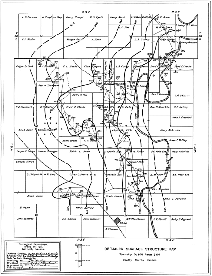
Structure--The oil of this field occurs in a lenticular sand body which, along with other beds, has been folded into a southwestward-trending nose. As shown on Figure 15, kindly supplied by the Trees Oil Company, the dips in the surface rocks are very slight. However, no hard beds that can be mapped throughout. any appreciable area crop out in the producing part of the field, and the surface nosing is projected from the data concerning the attitude of the Herington limestone obtained in sections 11, 2 and 3. Well records indicate that the buried rocks are more steeply folded. Structure contours (with 10-foot interval) drawn on the top of the Kansas City group show a pronounced nose trending southwestward, with perhaps a slight doming centering in the southwestern part of the SE NE, sec. 10. Several horizons were contoured, and at each the beds logged in the well drilled in the northwest corner of section 11 are higher than corresponding beds in the producing part of the field. The top of the Ordovician beds in the northwest corner of section 11 is 85 feet higher than in the northwest corner of the SE NE, sec. 10, and 107 feet higher than in the northwest corner of the SW, sec. 11. The Mississippian limestone is thinnest in the well drilled in the northwest corner of section 11. If it is assumed that the "Mississippi lime" had originally an equal thickness throughout the locality of all three wells, the dips in its upper surface thus restored closely parallels that of the Ordovician beds.
The accumulation of oil on what is structurally not the highest part of the fold may be accounted for by the pinching out of the producing sand body in the direction of the well in the northwest corner of section 11. Also, the pitch of the fold appears to flatten, and there may be in reality a structural depression, or saddle, between the northwest corner of section 11 and the producing wells in section 10.
Future drilling--The subsurface data show that the highest part of this fold lies northeast of the producing wells, as all beds have a higher altitude in the well drilled in the northwest corner of section 11 than in the wells drilled in section 10, and they may be still higher to the northeast, in the southern part of section 2. The surface structure map made by the Trees Oil Company (Fig. 15) shows it pronounced nose centering about the center of the south line of the SE SW, sec. 2. On the basis of these data it would appear that the well in the northwest corner of section 11 that obtained water in the Ordovician beds did not test the highest part of the fold, and that a well located about the middle of the south line or the center of the SE SW, sec. 2, might yield oil. The possibility that productive sand lenses in the Cherokee shale and higher beds may occur here is also not to be denied, but any well drilled should be continued 200 feet or more into the Ordovician beds. If shallow holes were core drilled in the S2, sec. 2, and N2, sec. 11, the information thus obtained should disclose the highest part of the fold more closely than can be done from present knowledge.
Figure 15--Detailed surface structure map of Tps. 30 and 31 S., Rs. 3 and 4 E. [A larger PDF version of this figure is available.]
Rock Field
Location--The Rock pool is in the northwestern part of the county, about 1 1/2 miles northeast of the town of Rock, in secs. 10, 11, 14 and 15, T. 30 S., R. 4 E. All but three of the producing oil wells are in the NW, sec. 14, and the NE, sec. 15.
History of development and production--Oil has been produced in the Rock pool for the last five years, the discovery well, in the northeast corner of section 15, on the Newton farm, having been brought in on January 13, 1923, with an initial production of 125 barrels of oil a day. [These data were supplied by T. R. Ermey, of the White Eagle Oil and Refining Company.] The peak production of the field was reached in October, 1923, when an average daily production of 763 barrels was made; the greatest yearly yield was made in 1924, when 226,000 barrels of oil was produced; and the greatest initial production for a single well was 150 barrels a day. [Figures obtained by calculations made from table of average daily production.] In October, 1927, the entire pool was producing 240 barrels of oil a day from 19 wells, and the total production of the field to that date was about 800,000 barrels. Only a very little gas, occurring with the oil, has been produced.
The following table, supplied by the White Eagle Oil and Refining Company, shows the average daily production of oil by months, in barrels, from the time of opening of the field through October, 1927.
| 1923 | 1924 | 1925 | 1926 | 1927 | |
|---|---|---|---|---|---|
| January | 67 | 542 | 548 | 422 | 298 |
| February | 118 | 592 | 486 | 368 | 285 |
| March | 110 | 588 | 485 | 858 | 281 |
| April | 234 | 665 | 436 | 373 | 278 |
| May | 650 | 657 | 511 | 351 | 272 |
| June | 661 | 673 | 512 | 333 | 271 |
| July | 579 | 696 | 482 | 363 | 254 |
| August | 592 | 700 | 517 | 361 | 260 |
| September | 726 | 606 | 482 | 324 | 289 |
| October | 763 | 686 | 480 | 335 | 241 |
| November | 657 | 628 | 443 | 314 | |
| December | 559 | 573 | 421 | 318 |
The total yearly production calculated from this table is as follows:
| Barrels | |
|---|---|
| 1923 | 173,610 |
| 1924 | 225,930 |
| 1925 | 176,487 |
| 1926 | 128,394 |
| 1927 (first 10 months only) | 81,912 |
| 786,333 |
The royalty fees derived from 11 of the 19 producing wells of the pool (those on the Newton farms) are received by the city of Winfield and applied toward the operation of a city hospital.
Properties of the oil--The following summarized analysis of the oil produced in the Rock pool was kindly supplied by the White Eagle Oil and Refining Company:
| Per cent | Gravity, deg. B. | Remarks. | |
|---|---|---|---|
| Gasoline | 35.87 | 120° initial, 431° end point. | |
| Kerosene | 9.37 | 42.0 | 140° flash point, (Foster cup). |
| Fuel oil | 59.43 | 24.9 | 240° flash point, 260° fire (Cleveland cup). |
| Loss | .33 | ||
| Color of oil, black. Gravity, 38.4° Baumé | |||
Surface and buried rocks--Most of the area of the Rock pool is underlain at the surface by the lower part of the Doyle shale, which is composed largely of thick beds of gray shale but contains a few thin beds of limestone that crop out and are mappable throughout part of the field. Beds of limestone in the upper part of the Fort Riley limestone crop out on the north, west and south sides of the field. Permian strata extend beneath the surface to a depth of about 300 feet, and the Pennsylvanian beds extend thence to a depth of about 2,850 feet. These series maintain in general the characteristics exhibited throughout the county, described under "Stratigraphy"; total thickness here is notably less than in the southern part of the county, however, and certain parts of the series, such as the Kansas City group, contain much greater percentage of limestone than farther south. The Mississippian limestone is about 350 feet thick and is reported in the logs of the one well in the field and others near by to consist of white and brown limestone--probably chert, inasmuch as one log reports it as sandy limestone--with "breaks" of shale in the lower part. The few wells in the vicinity of the Rock pool that have penetrated the Chattanooga shale beneath the Mississippian limestone report it as being about 40 feet thick; the next underlying strata have been penetrated for 100 feet and were reported to consist of shale, sandy shale, and thin beds of limestone that may belong to the Simpson formation or to other parts of the Ordovician system.
Figure 16--Map of the Rock pool, T. 30 S., R. 4 E., Cowley County.
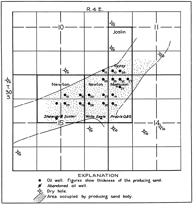
The producing sand lies at a depth of about 2,750 feet, in the lower part of the Cherokee shale and is separated from the "Mississippi lime" by about 50 feet of shale. Like sand bodies at this approximate stratigraphic position in other fields of this region, it is commonly known as the Bartlesville sand. As indicated in Figure 16, the sand is an elongate body, being about a half mile wide and more than a mile long; its longer dimension extends northeast. In the logs of all the dry holes . north of the producers and the two in section 15, south of them, no sand was reported at the horizon of the producing bed, although a few logs reported sandy shale; those drilled in the south one-half of section 14 found a thin sand carrying water. The sand body appears to be of the type which is so common in Greenwood County, northeast of this region, and which, because of the elongated shape, is frequently referred to as a "shoestring" sand (Cadman, 1927, p. 1151-1172).
| Locality | Farm name | Operating company |
|---|---|---|
| W2, SW sec 11 | Joslin | Gypsy Oil Co. |
| W2, NW sec. 14 | Magnuson | Prairie Oil and Gas Co. |
| E2, NE sec. 15 | Newton | White Eagle Oil and Refining Co. |
| W2, NE sec. 15 | Newton | Shawver & Sutter. |
| E2 NW sec. 15 | Newton | Shawver & Sutter. |
It is not known whether there is a definite relation between the attitude of the strata and the accumulation of oil here, as no detailed maps showing the structure of the surface beds in the Rock pool are available, but data supplied by the drilled wells indicate that the occurrence of oil is controlled in the main by the lensing out of the reservoir bed rather than by the structure. Altitudes on the top of a limestone unit in the lower half of the Shawnee group, which was encountered at depths of about 1,150 feet, show the beds to dip northwestward across the field at a comparatively uniform rate of about 50 feet to the mile. Data from the two wells near the center of section 15, southeast of the pool, indicate a slight reversal of dip toward the southeast, suggesting that the failure of these wells to produce oil may be attributed to their structural location. The map showing the regional attitude of the Mississippian limestone (Pl. XI) indicates that the producing sand body trends diagonally across the northwest flank of a broad southwestward-trending nose. The presence of this structural nose suggests that the attitude of the strata may have played a part in the accumulation of oil at this locality, although the lensing out of the reservoir bed is probably the more potent factor. However, Cadman states that the presence of oil in the "shoestring" sands in Greenwood County in general bears no relation to the attitude of the beds in the underlying Mississippian limestone nor to the local flexures in the overlying rocks (Cadman, 1927, p. 1170).
It appears probable that the productive area will be extended southwestward in the W2, sec. 15, and northeastward in the SW, sec. 11.
Eastman Field
Location--The Eastman pool is 4 miles east of Wilmot, in the northern part of Cowley County, in the extreme southwestern part of T. 30 S., R. 6 E., and northwestern part of T. 31 S., R. 6 E. It has a north-south elongation, and the length is several times the width.
History and production--The field was opened early in 1924 and by the end of that year had produced a little more than 200,000 barrels of oil. It produced 440,000 barrels of oil in 1925 and 315,000 barrels in 1926. In the spring of 1927, 37 wells were producing a total of about 800 barrels a month. Nineteen wells have produced large amounts of gas with the oil, but no data as to the total amount of gas produced are available. The aggregate initial daily production of the gas is 250,000,000 cubic feet. One well had an initial gas production of 35,000,000 cubic feet, five wells produced initially about 20,000,000 cubic feet each, and four wells averaged a little less than 15,000,000 cubic feet. The other gassers ranged from 3,000,000 to 10,000,000 cubic feet each. Oil was produced by 50 wells, of which 19 produced gas also. The oil producers had an average initial daily production of 180 barrels, and the gas wells averaged 13,000,000 cubic feet. There were no exceptionally. large producing oil wells in the field. Three wells had an initial daily production of a little more than 700 barrels, 27 had less than 100 barrels, and the others ranged between these limits. The wells in the Eastman pool are shown on Plates X and XI.
Quality of the oil--The crude oil from this pool is a paraffin-base oil with a greenish-brown color ranging in gravity from 340 to a little more than 36° Baumé. Two analyses typical of the oil from the Eastman pool, furnished by the Empire Gas and Fuel Company, are given below.
| Eastman No. 1, sec. 7, T. 31 S., R. 6 E. Empire laboratory No. A 564. Sample taken from flow while tools were in hole, December 13, 1921. Bartlesville sand; gravity, 34.1° Baumé: viscosity, thin liquid; color, reddish brown; water, 0.1 per cent; B. S., 0.9 per cent. Overpoint, 164° F. Time, 12 minutes. |
||||||
|---|---|---|---|---|---|---|
| Distillation: Engler method--1,000 cubic centimeters. | ||||||
| Per cent by volume |
Temperature, deg. F. |
Gravity, deg. B. |
Per cent by volume |
Temperature, deg. F. |
Gravity, deg. B. |
|
| 5 | 242 | 62.7 | 45 | 542 | 37.1 | |
| 10 | 300 | 55.2 | 50 | 560 | 35.7 | |
| 15 | 332 | 52.2 | 55 | 586 | 34.2 | |
| 20 | 390 | 48.6 | 60 | 610 | 33.6 | |
| 25 | 426 | 46.3 | 65 | 630 | 32.4 | |
| 80 | 460 | 43.0 | 70 | 648 | 31.3 | |
| 35 | 488 | 40.7 | 75 | 666 | 30.6 | |
| 40 | 520 | 38.9 | ||||
| Approximate summary. | ||||
|---|---|---|---|---|
| Per cent | Gravity, deg. B. |
Initial point, deg. F. |
End point, deg. F. |
|
| Gasoline | 9.0 | 58.6 | ||
| Naphtha | 11.5 | 50.5 | 188 | 480 |
| Kerosene | 17.5 | 42.6 | 292 | 600 |
| Gas oil | 36.1 | 33.6 | ||
| Residuum | 24.6 | 18.9 | ||
| Water | .6 | |||
| Loss | .7 | |||
| Martin & Wilson's Eastman No. 1, southwest corner sec. 5, T. 31 S., R. 6 E. Empire laboratory No. 2090. Production, 290 barrels of oil, 8,500,000 cubic feet of gas with the oil. Sampled February 8, 1924. Bartlesville sand, depth 2,850 feet. Viscosity, medium thin liquid; gravity, 36.3° Baumé: color, greenish brown; water, none; sulphur, 0.17 per cent; B. S., trace. Overpoint, 116° F. Time, 16 minutes. |
||||||
|---|---|---|---|---|---|---|
| Distillation: Engler method--1,000 cubic centimeters. | ||||||
| Per cent by volume |
Temperature, deg. F. |
Gravity, deg. B. |
Per cent by volume |
Temperature, deg. F. |
Gravity, deg. B. |
|
| 5 | 269 | 65.7 | 40 | 504 | 41.2 | |
| 10 | 302 | 58.7 | 45 | 547 | 38.9 | |
| 15 | 329 | 55.7 | 50 | 584 | 36.8 | |
| 20 | 364 | 52.3 | 55 | 620 | 35.4 | |
| 25 | 391 | 49.3 | 60 | 659 | 33.7 | |
| 30 | 426 | 46.6 | 65 | 694 | 32.1 | |
| 35 | 468 | 43.8 | 70 | 712 | 31.9 | |
| Approximate summary. | ||||
|---|---|---|---|---|
| Per cent | Gravity, deg. B. |
Initial point, deg. F. |
End point, deg. F. |
|
| Gasoline | 18.6 | 58.5 | 152 | 425 |
| Naphtha | 8.2 | 50.5 | ||
| Kerosene | 26.4 | 42.5 | 327 | 620 |
| Gas oil | 21.2 | 31.1 | ||
| Residuum | 20.0 | 22.5 | ||
| Water | .0 | |||
| Loss | .6 | |||
Surface and buried rocks--The surface in the Eastman field is occupied by rocks that belong to the Chase group, of Permian age. The rocks consist of alternately bedded shale and limestone, and the limestone contains an abundance of chert in the Florence flint, a formation of the Chase group. Outcropping ledges of limestone are fairly well exposed throughout much of the field and the surrounding-area. Most of the wells start in the Fort Riley limestone and penetrate underlying Pennsylvanian rocks to a depth of about 2,850 feet, where the producing sand body lies. Well-log correlation indicates that in the Eastman field the Permian rocks, including the Chase and Council Grove groups, extend to a depth of about 300 feet; the Wabaunsee group of Pennsylvanian rocks from that depth to a little more than 800 feet; the Shawnee group to a depth of about 1,550 feet, where the Oread limestone is struck; the Douglas and Lansing groups, consisting largely of shale, with some sandstone and limestone, from 1,550 to about 2,250 feet; the Kansas City and Marmaton groups, composed largely of limestone, with considerable shale in the Marmaton, from 2,250 to 2,700 feet; the Cherokee shale, consisting of shale and sandstone, to a little below 2,900 feet; the Mississippian limestone, consisting almost entirely of limestone, to about 3,300 feet, and beneath it less than 100 feet of black shale believed to be the Chattanooga shale underlain by the Ordovician strata. A thin sandstone underlain by limestone is recorded in the uppermost Ordovician beds.
The producing sand is correlated with the Bartlesville sand and lies in the lower part of the Cherokee shale. Drilling has shown it to be a lenticular sand body elongated in a north-south direction and being probably less than 2 miles wide from east to west. It ranges from a featheredge to 100 feet in thickness. Two thick sands were penetrated at shallower depths but yielded water-one in the lower part of the Shawnee, about 60 feet above the Oread limestone, struck at a depth of about 1,500 feet, and the other consisting of a series of sand in the lower part of the Douglas group and upper part of the Lansing group. More than 15 wells were drilled through the Bartlesville sands into the uppermost part of the Mississippian limestone; two wells were driven through the Mississippian into the Ordovician rocks, but these lower rocks yielded no oil or gas. One of these deep wells is the Crouch No. 4, in the southwest corner of the NE SE, sec. 31, T. 30 S., R. 6 E., drilled by C. W. Titus to a depth of 3,399 feet, and the other is the L. H. Spahr No. 1, in the southwest corner of the SE SW, sec. 5, T. 31 S., R. 6 E., drilled by the Southwestern Petroleum Company to a depth of 3,291 feet. The top of the Ordovician lies about 40 feet higher in the Spahr well than in the Crouch No. 4.
Structure--But little information concerning the attitude of the beds in the Eastman field was made available. The generalized structure map of this area is shown on the county map (Pl. XI), based on altitudes and logs of a part of the drilled wells. As shown on this map, the field appears to lie in an area that is slightly higher structurally than the region immediately surrounding it, but all wells drilled on this "high" do not produce oil or gas, and others situated off the highest part are producers. The data at hand do not furnish a satisfactory explanation as to the causes for production in some wells and the lack of it in others. Near the central part of section 6 production appears to be limited westward by the thinning of the producing sand body in that direction. However, a well drilled by the Lewis Oil Company in the southeast corner of the NW NE, sec. 31, T. 30 S., R. 6 E., appears to be located on the higher part of the structural flexure and to contain a thick body of sand at the Bartlesville sand horizon, but failed to produce. A similar situation exists for wells in the E2, sec. 7, T. 31 S., R. 6 E. No information as to the porosity of the sand body is available, but the lack of production under these conditions suggests that the sand may be not sufficiently porous here to serve as a reservoir for oil. East and west of the field wells have encountered no sand at the Bartlesville horizon. It can be said that in a broad way the lensing out of the sand body limits the productive area, but other factors must locally control the occurrence of oil and gas.
Dexter-Otto District
Location--The most pronounced structural feature in Cowley County is an extensive anticlinal fold that passes northward near Otto and Dexter, in the southeastern part of the county, and thence trends northeastward, passing near Grand Summit. (See Pl. XI and Fig. 18.) Small amounts of oil and gas have been produced on parts of this fold, the principal areas being a relatively small tract about a mile northwest of Otto, a larger area near Dexter, and a third about 3 miles northeast of Dexter. These three areas are designated herein respectively the Otto, Dexter, and Countryman fields.
Figure 17--Sketch showing wells in Dexter field.
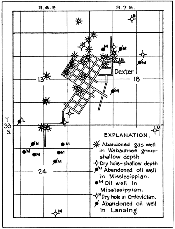
Figure 18--Map of the Dexter anticline. [A larger PDF version of this figure is available.]
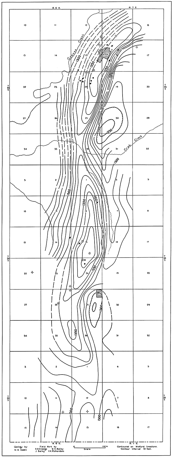
History and production--The Dexter field proper was one of the early gas pools of this part of the state and one which attracted wide interest because of the discovery by Cady and McFarland of helium in the gas from the discovery well, this being the first helium found in natural gas (Cady and McFarland, 1908, p. 228-302). Gas was discovered at Dexter early in 1903 at a depth of 325 feet, and by the end of 1908, 22 producing wells had been drilled (Haworth and McFarland, 1904, p. 191; Rogers, 1921, p. 76-77). Later drilling discovered more gas at depths near 1,000 feet, and oil was found at about 2,750 feet. Subsequent to the discovery of gas at Dexter wells were drilled a short distance northwest of Otto. Gas was found in fair abundance at a depth of about 1,100 feet and small amounts of oil near a depth of 3,000 feet. In recent years oil has been produced about 3 miles northeast of Dexter, in the Countryman field.
The shallow wells near Dexter had an average open-flow capacity of about 3,000,000 cubic feet of gas with an initial rock pressure of no pounds to the square inch (Rogers, 1921, p. 76). The discovery well had an initial open flow of 6,000,000 cubic feet of gas, and a few other wells had an open-flow capacity of 5,000,000 cubic feet. The wells near Otto that found gas at depths averaging about 1,100 feet had an initial production of less than 2,000,000 cubic feet each, with rock pressures of about 250 pounds to the square inch. The original wells near Dexter were abandoned years ago, but recently additional wells have been drilled to furnish gas to a plant erected to extract helium. The deep wells drilled for oil near Dexter and Otto have met with only slight success. The daily yield is extremely small, and several wells have been abandoned because the small production did not pay for the cost of operation. It is reported that the wells 3 miles northeast of Dexter, in the Countryman field, yield paying quantities of oil.
Helium content of gas--The gas of this district is noteworthy for its high content of helium. Commonly natural gas contains less than 0.3 per cent of helium, but the helium content of the gas from the Dexter-Otto district ranges from 1 to 2.1 per cent. Recently interest has been revived in the Dexter gas as a source of helium as a commercial product, and a number of samples of the gas have been analyzed by Dr. H. P. Cady at the State University. The following data are quoted from Rogers' report on the investigation of helium-bearing natural gas, carried on during the war in search for a supply of helium for inflating dirigibles (Rogers, 1921, p. 100, 101):
| Helium content | ||||||
|---|---|---|---|---|---|---|
| Rogers' report | ||||||
| Field | Name of well | Locality | Depth, feet |
Helium, per cent |
||
| Sec. | T. S. | R. E. | ||||
| Dexter | Discovery | 18 | 33 | 7 | 310 | 1.84 |
| Dexter | Greenwell | 18 | 33 | 7 | 310 | 1.64 |
| Dexter | (?) | 18 | 33 | 7 | 700 | .955 |
| Dexter | Hale | 13 | 33 | 7 | 350 | 1.83 |
| Dexter | Bolton | 13 | 33 | 7 | 350 | 1.68 |
| Otto | Day No. 1. | 24 | 34 | 6 | 1,145 | 1.90 |
| Otto | Melick | 13 | 34 | 6 | 1,150 | 0.50 |
| Results of analyses by Prof. H. P. Cady | ||||||
| Dexter | Olsen No. 1 | 1 | 33 | 7 | 0.78 | |
| 5 mi. southwest of Dexter | Esch No. 1 | 33 | 33 | 6 | 540 | 2.11 |
Surface rocks--Aside from the alluvium that occupies the bottoms along Grouse creek, rocks belonging to the Wabaunsee, Council Grove, and Chase groups crop out in the Dexter-Otto district. Near Dexter the valley of Grouse creek parallels in general the crest of the anticlinal fold and has been cut into the soft Eskridge shale, producing a broad valley with steep walls formed by the resistant limestone beds of the Cottonwood limestone, Garrison shale, and Wreford limestone. Throughout the rugged part of the district the Wreford limestone is the dominant rock at the surface and because of its superior hardness controls to a large extent the surface features of the district. The Eskridge shale occupies a part of the flat region immediately south of Dexter and because it consists of soft material is rarely exposed. The Cottonwood limestone exhibits its usual characteristics in a few exposures about a mile south of Dexter, in a road cut on the highway 4 1/2 miles south of Dexter, and capping the creek bank south of the producing oil wells 3 miles northeast of Dexter. The Garrison shale consists of gray, maroon, and green shale with several beds of hard gray limestone that form ledges in the slopes beneath the capping ledge made by the Wreford limestone. The Wreford limestone consists of beds of gray limestone and chert, exposed almost continuously on both sides of Grouse creek. The Matfield shale is not exposed, but its lowermost part is believed to form the rolling upland plains that slope gently downward to the rim rock or ledge formed by the Wreford limestone.
Buried rooks--Wells drilled in this district have penetrated the strata to a maximum depth of 4,010 feet, and a well about 5 miles southwest of Otto, a short distance west of the district, was drilled to a depth of 4,545 feet. Inasmuch as these deep wells were reported by the drillers to have struck granite, their logs furnish a complete section of the sedimentary rocks of the district. The Permian and Pennsylvanian rocks in this district consist of a series of interbedded limestone, shale, and sandstone similar to that found in other fields in this part of the state. The Pennsylvanian beds have a total thickness of a little less than 2,900 feet and exhibit in general the characteristics common to the remainder of the county. A few exceptions may be noted: The Cherokee shale is notably lacking in beds of sandstone except in one or two wells near Otto, a character that is fairly typical of the eastern part of the county, The Mississippian limestone as reported in well records in the district ranges in thickness from 300 to 390 feet, thinning over the crest of the Dexter-Otto fold. It is composed of limestone, sandy limestone, and thin beds of sandstone, logged as sandstone "breaks." It is from these sandstone "breaks" that most of the producing oil wells of the district derive their oil.
Some logs record about 50 feet of black shale immediately beneath the Mississippian limestone; this is believed to be the Chattanooga shale. Logs of other wells in the vicinity do not show shale at this horizon but report limestone, sandy limestone, or sandstone and limestone, of probable Ordovician age. Three wells on the western flank of the Dexter-Otto anticline record the Chattanooga shale--the Phillips Petroleum Company's Eckhart No. 1, in sec. 9, T. 35 S., R. 6 E., records the Chattanooga as 25 feet thick; the Mississippi Valley Oil Company's Spear No. 1, in sec. 21, T. 33 S., R. 6 W., records 50 feet of Chattanooga shale; and the Plateau Oil Company's Elliott No. 1, in sec. 16, T. 33 S., R. 6 E., records 52 feet. Only one deep well, the Phillips Petroleum Company's Julia McGill No. 1, in the NW, sec. 21, T. 34 S., R. 7 E., has been drilled in the syncline that parallels the Dexter-Otto fold on the east; 50 feet of Chattanooga shale was recorded in this well. Four wells, one in sec. 26, one in sec. 24, and one in sec. 12, T. 34 S., R. 6 E., and one in sec. 13, T. 33 S., R. 6 E., drilled near the crest of the fold, record no Chattanooga shale. Two other holes near the crest of the fold, in the vicinity of Dexter, record normal thicknesses of the shale, however--the Doric Oil Company's Smith No. 1, in sec. 18, and the Brown Bros. Riding No. 1, in sec. 7, T. 33 S., R. 7 E. If the well records cited above truly record the facts, they show that the Chattanooga shale is present low on the east and west flanks of the Dexter-Otto anticlinal fold and that it is present over parts but absent over other parts of the crest of the fold. These data may indicate that some folding took place after the deposition of the Chattanooga shale but before the deposition of the Mississippi limestone, and that the low structural ridge then formed was in part stripped of its covering of Chattanooga shale and later submerged and covered by Mississippian limestone. If it were not for the presence of the Chattanooga shale with normal thickness in the Smith and Riding wells it might be assumed that the Chattanooga shale was never deposited over the crest of the fold and that its absence is due to the overlapping of the Chattanooga sediments upon the flanks of a previously formed anticlinal ridge in the Ordovician rocks, the crest of which was not submerged in the Chattanooga sea. The presence of the shale in these two wells, however, indicates that the deposition of the Chattanooga shale extended across the site of the fold. The absence of Chattanooga shale in some wells and its presence in others might be explained by processes other than sedimentation. Faulting in the buried rocks might have brought the Mississippian beds into juxtaposition with Ordovician beds or other parts of the Mississippian rocks, so that some wells would pass from Mississippian rocks directly into Ordovician, or parts of the Mississippian might be repeated in a vertical hole, thus giving an abnormal thickness. Inasmuch as the rocks of each of these series are reported by the driller to be very similar, it would be impossible to tell by the logs alone whether the deeper rocks penetrated belonged to the Ordovician or Mississippian.
The few wells that have penetrated the rocks beneath the Chattanooga shale report a thick series of hard siliceous limestone interbedded with sandstone and relatively few thin beds of shale, the limestone beds comprising about two-thirds of the total thickness; and it appears probable that the beds reported as sandstone are also siliceous limestone. Little work to determine the age of these rocks has been done, and they are commonly grouped together as being Ordovician and Cambrian. The log of the Eckhart No. 1 well of the Phillips Petroleum Company, in the SW, sec. 9, T. 35 S., R. 6 E., reported a total thickness of 1,050 feet of beds referred to the Ordovician and Cambrian, overlying granite encountered at 4,545 feet. The Smith No. 1 well of the Doric Oil Company, in the northwest corner of the SE NW, sec. 18, T. 33 S., R. 7 E., penetrated a total thickness of 900 feet of sandy limestone and struck granite at a depth of 4,005 feet.
Rocks productive of oil and gas--The discovery gas well, drilled in 1905, and the wells drilled immediately afterward produced gas from a sandstone in the Admire shale at a depth of about 325 feet. Beds at this general horizon, although probably not the same beds, have produced gas elsewhere in Cowley County, particularly near Winfield and Arkansas City. Fairly strong flows of gas were struck at this horizon in the wells drilled in the Countryman field, 3 miles northeast of Dexter. It was in the gas from this sand that Cady and McFarland discovered helium gas, and so large a percentage of the gas produced from this sand at Dexter is noninflammable that users found it difficult to ignite. A series of sands in the lower part of the Shawnee group, about 150 feet above the Oread limestone, yielded appreciable flows of gas near Dexter and near Otto. These beds lie at a depth of about 1,000 feet near Dexter and a little more than 1,100 feet near Otto. Shows of gas were encountered at this horizon in the wells drilled in the Countryman field. Gas shows were found in sandstone beds in the Douglas group in wells drilled in the Countryman and Dexter fields. Sandy zones in the Lansing group produced shows of gas and oil in several wells near Dexter and in the Countryman field. The sandy upper part of the Kansas City group has produced oil in one well in the Countryman pool and supplied good shows of oil in other wells. Shows have been reported from this horizon in the Dexter pool. Shows of oil and gas have been reported from the lower part of the Marmaton group in the Countryman and Dexter pools, and a small production of oil was obtained from a bed at this horizon in one well near Otto. Another well near Otto had a show of oil in a sandstone in the lowermost part of the Cherokee shale; but no sand occurs at this horizon throughout most of the Dexter-Otto district.
The upper part of the Mississippian limestone is the chief oil-producing zone in the district. Sandy streaks in the limestone yield oil in the Dexter and the Countryman fields, and shows, together with some small production, are obtained from these beds near Otto. The production is so small, however, that it has never been of great importance. A few wells started off with a fair yield but quickly dropped to a very low daily production.
Several wells near the crest of the anticline in the Otto field are believed to have reached the upper part of the Ordovician strata; and three wells near Dexter have penetrated some distance into the Ordovician rocks, but yielded only disappointment. These beds have not been tested in the Countryman pool.
Structure--The Dexter-Otto anticline is the most extensive pronounced fold to be seen expressed in the surface rocks in Cowley County. A structure-contour map of the surface beds in the southern and central parts of the district was kindly supplied by M. W. Baden, of the Trees Oil Company, and is reproduced in Figure 18. The anticline trends nearly due northward from the state line, in sec. 13, T. 35 S., R. 6 E., to a point near Dexter and thence northeastward into secs. 33 and 27, T. 32 S., R. 7 E. Although farther northeast it is less distinctly reflected in the surface rocks, the fold is believed to continue beyond the county boundary, passing a little more than half a mile west of Grand Summit. According to Clark and Cooper (1927, p. 24) the trend of the Dexter-Otto fold continues southwestward in Oklahoma, where the Mervine and Ponca anticlines are on this trend and exhibit many features similar to the Dexter-Otto fold. Dome-shaped folds superposed on the major anticline and constituting only local features of it are shown on the structure map of the surface rocks of the southern part of the district (Fig. 18). The principal domes are one about a mile north of Otto, one near Dexter, and a third, not shown in Figure 18 but shown on Plate XI, about 3 miles northeast of Dexter. It seems probable that similar features may be present farther northeast, but detailed surface maps of this region were not available for use in this report, and so it is not known by the writer whether such features are actually present. The anticlinal fold is asymmetric in cross section, dips on the east side being greater than those on the west. According to Baden's map (Fig. 18), the surface rocks have a maximum dip eastward of about 100 feet in half a mile and a maximum dip westward of about 50 feet in half a mile. The average rate of dip is slightly less steep than the maximum, but throughout is steeper on the east side of the fold than on the west side. Wells that penetrate the Mississippian limestone are not so distributed as to afford much information for a comparison of the amount of dip in the surface beds with that of the buried Mississippian rocks, but such information as is disclosed by two wells southeast of Dexter, the Sinclair Oil and Gas Company's J. W. Searle well No. 1, in the SW, sec. 18 (see Pl. XI), and the Devonian Oil Co.'s Radcliff well No. 1, in the NE, sec. 19, T. 33 S., R. 7 E., show the surface rocks to dip about 80 feet southeastward in two-thirds of a mile and the upper surface of the Mississippian limestone to decline 155 feet in the same distance. To ascertain the true amount of dip in the Mississippian beds the amount of erosion of the uppermost Mississippian rocks should be known. On the basis of logs of wells drilled in this general region that show the Mississippian limestone thinner over the crest of the Dexter-Otto anticline than it is east and west of the crest, a conservative assumption of thinning by erosion between these two wells would be 25 feet, making the true dip of the Mississippian beds about 180 feet in two-thirds of a mile. Similar study of wells south of Dexter on the west flank of the fold indicates that the slope of the Mississippian surface adheres closely to the dip of the surface beds; but if a thinning of the Mississippian series by erosion is assumed to have taken place toward the crest of the fold the actual dip of the Mississippian rocks is slightly greater than that of the surface beds. Because no deep wells have been drilled far down the west flank, however, few definite data relative to the dip of the Mississippian rocks there are available.
Oil and gas possibilities--Although several wells in the vicinity of Dexter and Otto have been drilled into the Ordovician rocks and found them water bearing, not all the possible oil-bearing beds have been tested in all the structurally favorable areas on this fold. No deep wells have been drilled in the Countryman pool, and none have gone more than a few feet into Ordovician beds near Otto. The productive possibilities of stratigraphically higher beds have been determined in the principal parts of the district.
Falls City Field
Location--The Falls City field is in the southeastern part of Cowley County, in secs. 8, 9, 16 and 17, T. 35 S., R. 7 E. It extends southward across the state line into Oklahoma, but it is principally the Kansas part that is considered herein.
History, production, and character of gas and oil--The Falls City field was opened in 1916 by the discovery of an initial production of 7,000,000 cubic feet of gas at a depth of 1,480 feet in the Falls City Land and Cattle Company's well No. 1, in the center of the north line of the NE, sec. 17, T. 35 S., R. 7 E. Well No. 2, near the center of the NE, sec. 17, followed in the same year with an initial production of 6,000,000 cubic feet of gas having a rock pressure of 500 pounds to the square inch, derived from the same sand as that producing in well No. 1 (Roundy, P. V.; Unpublished manuscript in U. S. Geological Survey files). The field was later taken over and developed by the Phillips Petroleum Company. Beds deeper than the gas sand were found to contain oil, one producing bed occurring at a depth of 2,000 feet and a second at a depth of 2,700 feet. A total of 33 wells have been drilled in the Kansas part of the field, 7 of which have been dry holes. Eight producers and 3 dry holes have been drilled in the Oklahoma part of the field. The total oil production of the field to June 1, 1927, was 780,000 barrels; the total gas production to the same date is estimated by the Phillips Petroleum Company as a little more than 15,000,000,000 cubic feet. In June, 1927, the field was producing 10 barrels of oil a day from 21 wells. The oil has a gravity of 41.2° Baumé. [Most of these data supplied by Phillips Petroleum Company.] A chemical analysis of the oil, made in the laboratories of the Phillips Petroleum Company in January, 1927, is given below.
| Analysis of sample from Falls City field. Gravity, 42.3° A. T. I. @ t. 60° F.; B. S. and water, none; initial boiling point of crude, 77° F. |
||||
|---|---|---|---|---|
| Air distillation: Straight run, 300 cc. charge. | ||||
| Temperature Degree F | Volume, cubic cm |
Per cent | Gravity, deg. A. P. I. |
|
| Cut | Total | |||
| Up to 122 | 9.6 | 3.20 | 3.20 | 85.7 |
| 122-167 | 7.3 | 2.43 | 5.63 | 80.8 |
| 167-212 | 14.9 | 4.97 | 10.60 | 70.3 |
| 212-257 | 21.6 | 7.70 | 17.80 | 61.9 |
| 257-302 | 16.7 | 5.57 | 23.37 | 56.8 |
| 302-347 | 16.7 | 5.57 | 28.94 | 52.4 |
| 347-392 | 14.3 | 4.77 | 33.71 | 48.1 |
| 392-437 | 15.8 | 3.27 | 38.98 | 46.3 |
| 437-482 | 16.1 | 5.37 | 44.35 | 43.0 |
| 482-527 | 19.7 | 6.57 | 50.92 | 38.6 |
| Vacuum distillation at 40 mm | ||||
| Up to 392 | 11.8 | 3.93 | 3.93 | 36.4 |
| 392-437 | 18.6 | 6.20 | 10.13 | 35.0 |
| 437-482 | 16.1 | 5.37 | 15.50 | 32.2 |
| 482-527 | 16.3 | 5.43 | 20.93 | 30.0 |
| 527-572 | 11.1 | 3.70 | 24.63 | 28.9 |
| Distillation summary | ||||
| Per cent | Gravity at temperature 60 deg. F |
Gallons per barrel |
||
| Gasoline and naphtha | 33.71 | 61.9 | 14.15 | |
| Kerosene | 17.21 | 43.4 | 7.23 | |
| Gas oil | 10.13 | 35.6 | 4.25 | |
| Light lubricants | 10.80 | 4.53 | ||
| Medium lubricants | 3.70 | 1.55 | ||
| Viscous lubricants | 24.45 | 10.28 | ||
| Distillation loss | 10.00 | |||
The gas in this field has a high content of helium, according to the analyses of samples of gas from two wells in section 17, producing from a depth of 1,475 feet. The gas from one well contained 1.047 per cent of helium, and that from the other contained 0.94 per cent (Rogers, 1921, p. 101).
Surface rocks--The rocks exposed at the surface in the Falls City field belong to the upper part of the Wabaunsee group and to the Council Grove group. Named from the base upward, they are the Eskridge shale, Cottonwood limestone, and Garrison shale. The Cottonwood limestone is the most prominent formation cropping out in the region. It forms a sinuous ledge of hard, blue-gray limestone on both sides of Beaver creek and is particularly conspicuous on the east side. The limy shale that constitutes the uppermost part of the Eskridge shale is clearly exposed beneath the Cottonwood ledge and contains an abundance of fossils at many places in the vicinity of the field. Two thin beds of limestone that occur in the lowermost 50 feet of the Garrison shale, overlying the Cottonwood, crop out almost continuously throughout the district and with the Cottonwood limestone afford excellent key beds for structural mapping.
Buried rocks--The drill has penetrated the buried sedimentary rocks to a depth of about 3,200 feet. Major units within this interval can be correlated by means of well records with rocks that crop out in the eastern part of the state, but it is impossible to determine definite group boundaries or individual formations within the groups. Well-log correlation indicates that in the E. C. Lemaster well No. 1, in the southwest corner of the SE, sec. 8, T. 35 S., R. 7 E., beds of Pennsylvanian age extend from a few feet beneath the surface to a depth of 2,875 feet; the Wabaunsee group occupying the uppermost part and extending downward to a depth of about 550 feet, the Shawnee group from that depth to about 1,240 feet, the Douglas and Lansing groups from 1,240 to 1,980 feet, the Kansas City and Marmaton groups from 1,980 to 2,655 feet; and the Cherokee shale from 2,655 to 2,875 feet. The Mississippian limestone was encountered at a depth of 2,875 feet and extends nearly to the bottom of the hole, 3,212 feet, but this entire interval is reported as sandstone, and it is impossible to determine from the log whether rocks older than the Mississippian were penetrated.
Productive beds--Beds of economic importance because of their yield of oil and gas occur near the top of the Kansas City group, in the upper part of the Cherokee shale, and in the Lansing group. Most of the oil wells obtain their oil from sandstone in the upper part of the Kansas City group, encountered at a depth of about 2,000 feet. Wells Nos. 1, 3, 6, 13, 12, 9, 5, 4, 10 and 14, in the NE, sec. 17 (see Fig. 20), Nos. 26, 21 and 24, in the SE, sec. 17, and Nos. 16 and 19, in the W2, sec. 16, have produced oil from this horizon; their aggregate initial production was about 1,000 barrels of oil a day. A few wells have produced oil from a lenticular sandstone, which is not present in all wells. This sandstone occurs in the upper part of the Cherokee shale and was encountered at a depth of about 2,700 feet. It has yielded oil in well No. 7, near the center of the E2, sec. 17; a show of oil in well No. 1, in the northeast corner of the SW, sec. 17; and gas in wells Nos. 20A and 29A, in the SE, sec. 17. Two gassers--well No. 17, near the southwest corner of sec. 16, and well No. 6, in the NE, sec. 17--derive their gas from a sandstone in the lower part of the Lansing group lying a little more than 1,800 feet beneath the surface. The sand body is extremely lenticular in habit. No sand is recorded at this horizon in wells Nos. 10 and 12, on the crest of the fold. Other wells encountered a considerable thickness of sand that contained water. Gas is produced from a sandstone that is about 350 feet above the bed just described and is believed to be near. the contact of the Lansing and Douglas groups. It was the discovery of gas in this sand that opened the field. The sand body is lenticular. In the NE, sec. 17, well No. 1 had an initial production of 7,000,000 cubic feet of gas from this sand, and wells Nos. 2, 4 and 7 each had an initial production of 5,000,000 cubic feet. A number of shows of gas and oil were reported from the uppermost part of the Lawrence shale, a sandy zone close beneath the Oread limestone, in many wells drilled in the NE, sec. 17, the SE, sec. 8, and at scattered localities elsewhere in the field.
Structure--According to the surface structure map shown in Figure 19, supplied by the Phillips Petroleum Company, the Falls City field is developed on an anticlinal nose trending southwestward through the NE, sec. 17.
Figure 19--Map showing attitude of surface beds in Falls City field and vicinity.
Production from the principal producing zone (the uppermost part of the Kansas City group) appears to be controlled by the attitude of the rocks, inasmuch as it is confined to the higher parts of the fold. The lenticular shape of the sand bodies, coupled with the structure, appears to be the factor that controls production in the other producing beds. Possible producing zones beneath the upper part of the Cherokee shale have not been tested with the drill on the higher part of the fold. Three holes--the E. C. Lemaster No. 1, in the SW SE, sec. 8; the Easly No. 1, in the northeast corner of the SW, sec. 17, and the Falls City No. 16, in the SW NW, sec. 16, have been drilled into rocks that lie beneath the Pennsylvania beds. The Lemaster and Easly holes are far down the west flank of the fold and so do not constitute adequate tests of the lowermost Pennsylvanian nor of the Mississippian and Ordovician rocks, all of which produce oil elsewhere in the Midcontinent region. The Falls City No. 16 well is on the east flank of the fold, as shown by the subsurface map, and it was not drilled to a sufficient depth to test the Ordovician rocks, but it did penetrate the lowermost Pennsylvanian and the uppermost 100 feet of the Mississippian beds. In this well a sand body only 5 feet thick was logged at the base of the Cherokee shale, and one 15 feet thick was logged 140 feet above the base. The Cherokee shale was reported to contain no beds of sandstone in the Lemaster and Easly wells mentioned above. Consequently it appears unlikely that reservoir beds are present in the lower part of the Cherokee shale on the highest part of the fold. The "2,700-foot" producing sand, which is a sandstone in the upper part of the Cherokee shale, has been shown to be present and contain oil in a few wells in the northeast one-fourth and southeast one-fourth of section 17 and is probably present on the highest part of the fold. The Mississippian rocks are not known to contain oil in close proximity to this field, but commonly produce at a number of localities in this general region of Kansas and Oklahoma. Beds of Ordovician age yield an abundance of oil in fields not remote from the Falls City field. Should these lower beds be tested with the drill here the test well should be located on the highest part of the dome, which is near the site of well No. 1; in the northeast one-fourth of section 17, according to the subsurface map shown in Figure 20, and drilling should continue through a thickness of at least 150 to 200 feet beneath the base of the Chattanooga shale. A total depth of 3,500 feet should be ample. Production from the lowermost Cherokee or the Mississippian beds appears. unlikely, but the possibility of obtaining oil in the Ordovician rocks cannot be positively eliminated until such a test is made. A dome with a small closure on the east is shown in the northeast one-fourth of section 17 by the subsurface structure map, supplied by the same company (Fig. 20).
Figure 20--Subsurface structure-contour map of Falls City field.
Other Fields in the County
Clarke pool--Three producing oil wells surrounded by dry holes have been drilled in sec. 6, T. 31 S., R. 4 E., on Walnut river. Alluvium of the Walnut river valley occupies the surface. The wells produce oil from a lenticular body of sand occurring at a depth of 2,840 feet, in the lowermost part of the Cherokee shale. No sand occurs at this horizon in most of the wells surrounding the producers. Two wells, one drilled in the northeast corner of the southwest one-fourth of section 6 and the other in the northwest corner of the southwest one-fourth of northeast one-fourth of section 6 penetrated a thin bed of sand, but these wells are far down the flank of the fold on which the field is situated. Inasmuch as the oil of this region commonly occurs in the highest part of the folds, the absence of oil in appreciable amounts in these two wells may be explained on the assumption that they were unfavorably located structurally. One well, the Donovan No. 1 of the Benedum and Trees Company, has been drilled to the Ordovician beds. It showed the Mississippian limestone to be thick and found no oil in the Ordovician rocks. The crude oil from the Clarke No. 1 well has a specific gravity of 0.8271 at a temperature of 15° C., a Baumé gravity of 39.2°, and a viscosity of 1.31 at 20° C (Whitaker, Campbell, and Estes, 1917, p. 181).
Udall pool--Oil was discovered 2 miles north of Udall in 1926 on a dome-shaped uplift alined with the axis of the buried "granite ridge" that extends across Kansas into Oklahoma. Oil was found at a depth of 1,850 feet in sands in the upper part of the Douglas group, close beneath the Oread limestone. One well was drilled deeper, and more oil was found at 2,050 feet in a sandstone, called the Stalnaker sand, that occurs about at the contact of the Douglas and Lansing groups, and is herein placed in the uppermost part of the Lansing. (See Pl. II.) This sand produces oil in the Churchill and Oxford pools, a few miles to the southwest, in eastern Sumner County. Some oil was found in sand near the base of the Cherokee shale, and a show of oil was obtained from chert a few feet below it. The drill penetrated about 50 feet into the Mississippian limestone, and the well was plugged back to the Stalnaker sand. Four wells, three of which produce oil from the "1,850-foot" sand and one from the Stalnaker sand, have been drilled about the corner common to sections 20, 21 28 and 29. The field is being extended by wells drilled to the shallower sand. The possibility of production from the Cherokee sand has not been entirely eliminated by the one deep well, and the Ordovician beds remain yet untested.
Redbud dome--Another dome-shaped fold occurs about 3 miles northeast of the Udall pool, in sec. 10, T. 30, R. 3 E., in line with the "granite ridge." The Permian rocks that occupy the surface are well exposed, so that their attitude is readily determined by a surface examination of the area. The Winfield limestone dips westward beneath overlying beds in the east half of section 14 but again rises to the surface in the north-central part of section 10, near the crest of the dome. Two holes have been drilled in the area; one near the crest of the dome was stopped in the upper Mississippian limestone beds, or possibly the Ordovician beds if the "Mississippi lime" is absent, and the other, far down the west flank of the dome, was drilled into the Ordovician beds. Neither well obtained oil in commercial quantity, although shows of oil were obtained from beds at two horizons in the Shawnee group, from the upper part of the Douglas, from the uppermost part of the Stalnaker sand, from sand in the lower part of the Lansing, and, in the well drilled near the crest of the dome, from sandy shale containing coal in the lowermost part of the Cherokee shale. If the Ordovician beds have not yet been tested on the higher part of the fold they remain as a possible source of oil.
Sec. 30, T. 30 S., R. 4 E.--Oil was discovered early in 1927 in sand in the lower part of the Cherokee shale in sec. 30, T. 30 S., R. 4 E., about 2 miles southwest of Rock. The settled production of the well was relatively small. The site for the well was chosen on the basis of structural data disclosed by core drilling. The sand body found here may be the southwestward continuation of the producing sand of the Rock field.
Sec. 28, T. 31 S., R. 4 E.--Oil was found in 1926 in a well drilled about 2 miles southeast of Akron, in the northwest corner of the NE, sec. 28, T. 31 S., R. 4 E., at a depth of about 2,400 feet, in sandstone and sandy limestone in the upper part of the Kansas City group. Dry holes have been drilled northwest and south of the discovery well, but drilling in 1927 has extended the known productive area eastward to the southeastern part of section 21 and northeastern part of section 28. The wells produced initially between 75 and 125 barrels of oil a day. One hole has been drilled to the top of the Mississippian limestone-the Lewis No. 2 well, in the southwest corner of the NW NE, sec. 28. It found no sand in the Cherokee shale. A structure-contour map of the surface beds, supplied by the Trees Oil Company, is shown in Figure 21.
Figure 21--Map showing attitude of surface beds in parts of Tps. 31 and 32 S., R. 4 E.
Wilmot gas field--Twenty or more shallow wells have produced gas in a rather wide area between Wilmot and Floral. The gas occurs in thin beds of sandstone in the upper part of the Admire shale, at depths of about 600 feet. Several holes in the general area have been drilled to the Mississippian limestone, and others have tested also the Ordovician beds. A well drilled in the northwest corner of sec. 9, T. 31 S., R. 5 E., found a show of oil in sandstone near the middle of the Shawnee group, another in the upper part of the Douglas group, and another in the Lansing; a thick sandstone near the Lansing-Douglas contact yielded water, the upper part of the Mississippian limestone furnished a show of oil, and the Ordovician beds produced water. No sand was found in the Cherokee shale nor in the upper part of the Kansas City group, though oil is obtained at these two horizons elsewhere in the county. Few altitudes of the drilled wells are available for use in a structural study of the. area, and so only a regional structural picture is shown on Plate XI. The general attitude of the buried Mississippian beds appears to be that of a gently dipping broad anticlinal nose trending southwestward through the gas field, in approximate alinement with the State School pool, near Winfield.
Floral gas field--Several gas wells that. have produced as much as 8,000,000 cubic feet of gas a day have been drilled about a mile south of Floral. The gas occurs in sandstone beds in the upper part of the Douglas group, a short distance beneath the Oread limestone. Sands at this horizon produce oil in the Udall pool, about 12 miles northwest of this area. The gas wells are on a northeastward-trending fold that may be the continuation of the fold in the Wilmot gas field or may lie en echelon with it. The general attitude of the buried rocks is shown on the county map (Pl. XI).
Sec. 6, T. 30 S., R. 6 E.--One well produces oil from sand near the base of the Cherokee shale in the northwest corner of sec. 6, T. 30 S., R. 6 E., a short distance south of the Fox-Bush pool, of Butler County. Dry holes have been drilled at the east and west offset locations, and another was drilled about half. a mile southeast of the well.
Mahannah pool--Three or four small oil producers have been drilled in the western part of sec. 6, T. 30 S., R. 8 E., in the northeastern part of the county. The oil is derived from a sandy zone near the top of the Mississippian limestone. One well was drilled to a depth of 3,130 feet and found a show of oil in the upper part of the Mississippian limestone and water in the uppermost Ordovician beds.
Roth-Faurot pool--The south end of a small oil pool known as the Roth-Faurot pool extends into the extreme northeastern part of Cowley County, in the north-central part of sec. 4, T. 30 S., R. 8 E. The oil is produced from sandstone in the lower part of the Kansas City group, which was encountered at depths of about 2,150 feet. Some gas and oil were found at several horizons in the Kansas City group above the chief producing bed. Few structural data concerning this area are available. The information disclosed by the few altitudes of wells that are at hand indicates that the oil has accumulated in the higher part of a southwestward-trending anticline or nose.
Grand Summit pool--Three wells, two of which are just west and the third immediately east of the county boundary about 11/2 miles northeast of Grand Summit siding, in secs. 3 and 4, T. 31 S., R. 8 E., were drilled in the winter of 1926-'27 by the Minnehoma Oil and Gas Company. From 5,000,000 to 8,000,000 cubic feet of gas was struck in each well at a depth of about 1,800 feet, in sandstone in the uppermost part of the Kansas City group. More gas and sufficient oil for a daily production of about 25 barrels per well was found in porous limestone about 200 feet lower in the Kansas City group.
Sec. 18, T. 32 S., R. 6 E.--A well drilled in the southeast corner of the SW NE, sec. 18, T. 32 S., R. 6 E., produced a small amount of oil from a sandy zone about 100 feet beneath the top of the Mississippian limestone. Five shows of gas and five shows of oil were encountered in the well, which was drilled to a depth of 3,472 feet.
Empire-McCormick pool--Four wells surrounding the center of sec. 13, T. 31 S., R. 7 E., were drilled in 1922-'23. The area is known as the Empire-McCormick pool. The McCormick No. 1 well, in the northwest corner of the SE, sec. 13, produced initially 4 1/2 barrels of oil a day from sand a little way below the middle of the Cherokee shale. It had a good flow of gas from a thick sandstone (Layton sand) in the uppermost part of the Kansas City group, struck at 2,040 feet, more gas at 2,240 feet, 500,000 cubic feet of gas at 2,320 feet, and a show of oil in the Fort Scott limestone at 2,532 feet. The well was abandoned, but the Brown No. 1, drilled as the north offset to it, produced oil from the sand in the Cherokee. The log of the Brown No. 2 well, in the southeast corner of the NW, sec. 13, records a bed of "red rock" showing no oil at the horizon of the producing Cherokee sand. This well was drilled into beds near the base of the Mississippian limestone and then plugged back to the gas sand (Layton sand) in the uppermost part of the Kansas City group, which yielded 2,500,000 cubic feet of gas a day under a rock pressure of 325 pounds to the square inch. The Keilhorn No. 1 well, in the northwest corner of the SW, sec. 13, showed a very thin bed of dry sand in the Cherokee shale and after testing the uppermost few feet of the Mississippian limestone was plugged back to the Layton sand, from which 5,500,000 cubic feet of gas was produced daily under a rock pressure of 460 pounds to the square inch. Two of these wells produced shows of gas from sandstone in the Admire- shale, encountered at a depth of 500 feet, and one well yielded a show of gas from sandstone in the upper part of the Douglas group, immediately beneath the Oread limestone. A thick bed of sandstone capable of serving as a gas and oil reservoir, in the lower part of the Shawnee group, less than 100 feet above the Oread, produced a "hole full of water" in these wells. A well was drilled in 1925 in the northeast corner of the SW NE, sec. 13, northeast of the producers, to a depth of 3,345 feet, penetrating all beds to the upper part of the Ordovician rocks. The Chattanooga shale appears to be absent in this part of the county, and so the Mississippian and Ordovician beds, which are both reported as being mostly limestone, cannot be distinguished by the well logs. The lowermost 510 feet penetrated is reported as limestone with a few beds of sandstone; the lowermost 150 feet, more or less, may be of Ordovician age and the remaining upper part of the 510 feet Mississippian. This well passed through 35 feet of sand between beds of "red rock" in the Cherokee shale, but it failed to produce oil. Shows of oil and gas were obtained at several horizons in the Kansas City and Marmaton groups.
Little information concerning the attitude of the strata in the field is available. The regional structural study shown on Plate XI indicates that the oil and gas occur on a structurally "high" area, but drilled wells in this part of the county are so widely spaced that no details of the fold could be learned from the well records.
Olsen pool--Oil was found by drilling carried on about 1922-'23 7 miles south of Hooser, on the Olsen farm, in sec. 1, T. 35 S., R. 7 E. Eight or more oil wells and two gas wells have been drilled here. The yield of the wells has been small, commonly ranging between 50 and 75 barrels a day initially for each well, but production is still maintained. The oil is found at a depth of about 2,375 feet, in sandstone that occurs in about the middle of the Marmaton group. Good shows of oil and gas were encountered at several horizons in the Kansas City group, which is here composed chiefly of sandstone and shale. From 11,000,000 to 18,000,000 cubic feet of gas Was found in a sandstone in the middle part of the Lansing group, struck at about 1,700 feet. Thick beds of sandstone occur near the contact of the Douglas and Lansing groups and in the lower part of the Shawnee group but contain water. A well in the SE, sec. 1, southeast of the pool, was drilled through the Pennsylvanian and Mississippian beds into the Ordovician rocks. It found no sands in the Cherokee shale, and aside from a small show of oil in the uppermost beds of the Mississippian limestone it, gave no encouragement for oil or gas production from the beds beneath the sand that produces oil in the Olsen pool. The well is far down the flank of the fold, however, and does not constitute a conclusive test of the deeper-lying beds of the Olsen field.
The attitude of the surface rocks, which consist of limestone and shale beds in the upper part of the Wabaunsee group, can be readily determined by a detailed surface survey, inasmuch as outcrops of mappable rock layers are comparatively numerous and widely distributed in the vicinity of the field. According to a structural map of the area (Fig. 22), kindly furnished by the Phillips Petroleum Company, the surface rocks dip in general westward at the rate of about 40 feet to the mile, with a nosing that trends westward and passes just north of the center of section 1.
Figure 22--Map showing attitude of surface beds in Olsen field.
Arkansas City district--A large amount of gas and some oil have been produced near Arkansas City, in southern Cowley County. The principal development took place about 1916, but many of the wells were abandoned a few years later, and even records of their locations and logs of the wells are now difficult to obtain. The principal gas-producing districts, shown in Figure 23, were in an area centering about 2 miles north of Arkansas City, in secs. 18 and 7, T. 34 S., R. 4 E.; a small area 2 miles farther northeast, in the N2, sec. 5, T. 34 S., R. 4 E.; a small area about 2 miles northeast of Arkansas City, surrounding the south quarter corner of sec. 17, T. 34 S., R. 4 E.; and a small area about 3 miles southeast of Arkansas City, in the NE, sec. 4, T. 35 S., R. 4 E.
Figure 23--Plat showing wells in Arkansas City district.
In the comparatively large area centering in sections 7 and 18 the. gas was produced chiefly from a sandstone in the upper part of the Admire shale that appears to be continuous throughout much of the field and was encountered at depths ranging from 650 to 850 feet. Very little information about the yield of the wells is available, but the logs of several wells record yields between 1,000,000 and 2,000,000 cubic feet a day. Several other beds stratigraphically higher than the chief gas-producing sand (up to a level within 200 feet of the surface) yielded shows of gas. One well in the northwest quarter of section 8 was drilled to a depth of 3,510 feet, but lower beds that yield oil and gas elsewhere in the county failed to produce here. This well, however was drilled in an area that fails to produce even from the shallow gas sand, and so it may not constitute a conclusive test.
A few wells in the N2, sec. 5, T. 34 S., R. 4 E., have produced gas from the sandstone in the upper part of the Admire shale. Yields ranging between 200,000 and 5,000,000 cubic feet a day were reported for the wells. Two wells were drilled to a depth a little greater than 2,500 feet and penetrated a number of water-bearing sands in the Shawnee, Douglas, and Lansing groups, stopping in the lower part of the Lansing.
The wells surrounding the south quarter corner of section 17 yielded as much as 8,000,000 cubic feet of gas each from sands in the upper part of the Admire shale, which was struck at depths between 650 and 750 feet. A well in the northwest corner of the NE, sec. 20, near the center of the field, was drilled to a depth of 3,740 feet and thus tested the uppermost Ordovician beds and all beds above them. According to the record of this well thick beds of sandstone capable of serving as reservoir beds for oil and gas are fairly abundant in the lower part of the Shawnee group. Others occur in the Douglas group, and a sandstone unit more than 150 feet thick occurs near the Douglas-Lansing contact. More sand was struck lower in the Lansing, and the upper half of the Kansas City group is sandstone instead of being composed of limestone, as it is farther north in the county. A thin sandstone occurs in the lower part of the Cherokee shale. All these beds, as well as sandstone in the uppermost part of the Ordovician beds, failed to yield oil or gas.
Gas is produced from the upper part of the sand that occurs near the contact of the Douglas and Lansing groups, which were struck at about 1,930 feet in sec. 4, T. 35 S., R. 4 E. Sands in the Shawnee group, which was struck at depths between 1,400 and 1,500 feet, also yielded some gas. One well near the gas well was drilled to a depth of 3,645 feet, testing all beds to the uppermost few feet of the Pre-Chattanooga beds, possibly Ordovician (?). Shows of oil and gas were found in the Marmaton group at 2,850 feet and in sands in the Cherokee shale at 3,100 and 3,250 feet. The uppermost beds in the Mississippian and also the Pre-Chattanooga beds yielded water.
An initial daily production of 8,000,000 cubic feet of gas was found in sandstone in the upper part of the Lansing group, which was . struck at a depth of 1,900 feet in a well 4 miles northeast of Arkansas City, in the northwest corner of the SE, sec. 14, T. 34 S., R. 4 E. A well half a mile farther east, in section 13, also produced some gas, but it is not known from what depth or at what stratigraphic horizon. These two wells are on the general trend of the Beaumont arch, a long structural fold that extends through Greenwood County and southeastern Butler County and enters Cowley County near its northeast corner, extending thence southwestward nearly across the county, as shown on Plate XI.
T. 34 S., R. 3 E.--Several more or less widely separated wells in T. 34 S., R. 3 E., have produced oil or gas and some of them may prove to have been openers of pools. Two wells drilled by the Roxana Petroleum Corporation in section 16, on the Chaplin farm, have produced gas from sands in the upper part of the Shawnee group, which was struck at depths of a little more than 1,400 feet; one well yielded initially 1,500,000 cubic feet and the other 2,500,000 cubic feet of gas a day. This sand produced initially 24,000,000 cubic feet of gas in the Mullet No. 1 well of the Marland Oil Company in the southwest corner of the SE, sec. 31, completed in the middle in November, 1926.
Oil has recently been produced from sand in the lower part of the Cherokee shale in wells drilled about the corner common to sections 16, 17, 20 and 21. The well in the southeast corner of section 17 had an initial production of 100 barrels of oil a day; the well in the northeast corner of section 20 yielded 25 barrels a day; the one in the northwest corner of section 21 is a dry hole. These wells are in the area occupied at the surface by the Wellington formation, which is composed chiefly of soft beds of shale. No reliable key beds for structural mapping crop out in much of the area, and the attitude of the strata must be determined by data disclosed by the drilling of shallow holes from which cores of the beds are taken.
A well that produced initially 60 barrels of oil a day was drilled in 1926 by the Gypsy Oil Company in the southeast corner of the NW, sec. 5, on the Martin farm. The oil was found in "chat" that lies upon the "Mississippi lime." Gas is reported to have been produced in one well in the S2, sec. 11, but no data are at hand as to the depth of the producing bed or the yield of gas.
Sec. 33, T. 33 S., R. 3 E.--Gas is reported to have been produced from sand in the Admire shale at a depth a little greater than 900 feet in a well in the NE, sec. 33, T. 33 S., R. 3 E., a short distance southeast of the Rainbow Bend field.
Industries Related to the Exploitation of Oil and Gas
Refineries
A part of Cowley County's oil is refined within her borders. The largest refinery is that of the Roxana Petroleum Corporation, at Arkansas City. It has a daily capacity of 20,000 barrels and operates at more than three-fourths capacity much of the time. The Arkansas City Refining Company's plant, with a daily capacity of 8,000 barrels, and the Kanotex Refining Company's plant, with a daily capacity of 10,000 barrels, are also at Arkansas City. Some oil from Cowley County goes to the plants of the Barnsdall Refineries (Inc.), and Derby Oil Company, in Wichita, and a part goes to refineries at Ponca City, Okla.
Gasoline-Extraction Plants
There are in Cowley County several plants that extract gasoline from the gas produced. A large plant of the absorption type in the Rainbow Bend field was extracting about 8,500 gallons of 85-degree gasoline from 4,000,000 cubic feet of gas a day at the time of the field examination. A greater production was made when the field was producing more gas. The peak gas production of the field occurred in the summer of 1925, when 112,000,000 cubic feet of gas a day was produced, averaging in gasoline content between 1.5 and 1.6 gallons per 1,000 cubic feet.ll9 The capacity of the plant, however, was not sufficient to permit handling all the gas during the peak-production year. The present gasoline content of the gas produced at Rainbow Bend averages about 2.2 gallons per 1,000 cubic feet (R. B. Rutledge, personal communication).
A plant of similar type in the Winfield field treats gas from three sands-the "1,400-foot," "2,300-foot" and "3,000-foot Bartlesville." The gas from the last-named sand is the richest in gasoline. About 4,000 gallons of 85-degree gasoline was being produced daily at the time of the field examination. The gas treated averages about one-half to one-third gallon of gasoline per 1,000 cubic feet. There is another plant at Arkansas City and another in the Eastman field, but no data as to their production were obtained.
The general process followed in these plants is to pass the gas through a specially prepared oil, which absorbs the gasoline. The saturated oil is then heated under pressure. The gases given off are passed through cooling coils, where they condense to liquid. The product is a gasoline of very high gravity that is used to blend with low-grade gasoline. It is not blended at the plant, however, but is marketed to refiners. Considerable loss occurs in loading the gasoline because of its highly volatile character. To minimize the loss it is common practice to load at night and take other precautions to diminish evaporation.
Compression Plants
One large gas "booster station" has been built in the county. This is one of numerous plants where the gas of the trunk lines is compressed and returned to the lines under pressure. Gas has recently been employed in the county to increase the production of oil wells. Oil wells in the State School pool are made to flow by using gas that is produced in the field. The gas is first compressed and then forced into the well through casing surrounding the tubing; it returns through the tubing and lifts the oil with it.
Helium Plant
One of the most interesting industries to enter the county is that engaged in the commercial extraction of helium. The discovery of helium in natural gas was made in Cowley County more than 20 years ago, and the county now possesses at Dexter the only plant in the country engaged in extracting helium for commercial use. The story of helium gas at Dexter is told in a most interesting article by J. L. Dwyer, in the Oil and Gas Journal for March 1, 1928, quoted in entirety below:
The only plant in the world devoted to the commercial production of helium is owned by the Helium Company, and is located at Dexter, Cowley County, Kansas, in the southeastern part of the state. There is one other plant which makes helium, located at Fort Worth, Tex., and owned by the federal government and operated by the helium division of the United States Bureau of Mines. The combined output of these two plants constitutes the total production of this valuable gas, upon which the future expansion of airship construction and progress so greatly depends. The two plants are strictly competitive because, under a ruling of congress, the government plant may operate and produce helium only when it can do so at a figure which compares favorably with the cost of the product of commercial plants. The federal plant is supported by congressional appropriation.
The Helium Company (which is a subsidiary of the Kentucky Oxygen and Hydrogen Company, of Louisville, Ky.) was attracted by the possibilities of extracting helium from natural gas. Plans and contracts for a supply of suitable natural gas were made, and ground for the plant was broken on May 1, 1927. The plant was in operation, and the first cylinder of helium was shipped on September 1, 1927, and since that time, the plant has been in active operation.
According to the statement of R. R. Bottoms, general manager of the company, the natural gas which is produced in this part of Kansas abounds in traces of helium, but the majority of gases do not contain sufficient quantities to warrant processing. The history of helium discovery in Kansas is interesting and might be related.
In 1906 a wildcat well drilled on the edge of the town of Dexter found natural gas at a depth of 500 feet. This well apparently meant a great deal to the community and created much interest in a spot which had been confined to agriculture. There was unlimited publicity attendant upon this gas well, and the town fathers decided to make a gala day of the occasion. A band was hired, speakers were obtained, and a holiday proclaimed.
Everything Went Well, Except
The program was to have been an introductory speech by the mayor, who would then touch a torch to the well and allow the gas to shoot many feet into the air. After this spectacular performance the various speakers were to have been introduced, and their chief mission was to dwell upon the boon which the gas would prove to the growth of the town. Industries were assumed to be anxious to locate at Dexter on account of the cheap fuel which would be provided, and all was rosy.
The first part of the program was perfect. Lines were laid from the well to the speakers' stand, and the mayor made his introductory remarks, and then the gas was turned on, and the torch held by the mayor was lighted and applied to the end of the pipe. To the amazement of all, the torch was blown out by the gas. It was concluded that the pressure of the gas was too great, and accordingly, the output was pinched in, and a second torch applied. It suffered a fate similar to the first. The town dads were good and mad by this time, and a decidedly damp blanket was thrown over the celebration, but in an effort to snatch victory from defeat a huge bonfire was built near the end of the pipe, and when it was going good the gas was turned into the bonfire. The bonfire went out like the torches.
The celebration was completely blown up, and the town authorities sent for Dr. H. P. Cady, a professor of Kansas University. After examining the gas, Doctor Cady found that it contained a good percentage of helium. The helium was never put to use until the Dexter plant was started.
Opposite of Refinery
There are innumerable features about a helium plant, and probably the most terse manner of describing it is to state that it is exactly the opposite of an oil refinery. The refinery takes liquids and, after vaporizing them, separates the vapors, various products being derived from these vapors. A helium plant does exactly opposite. It takes natural gas and liquefies the various elements found in it. After liquefaction takes place, the helium, which is the least liquefiable of the elements in the natural gas, is left in gas form and is placed in cylinders similar to oxygen cylinders.
In oil refining the temperatures of the liquids are raised, in order to vaporize the contents, the lighter hydrocarbons being driven off first. In helium extraction the temperatures of the gases are decreased until the liquefaction temperatures are reached, and since helium has a much lower liquefaction temperature than any of the other elements in natural gas, it remains after the methane, butane, nitrogen,. and hydrogen are removed. The liquefaction temperature of nitrogen is 1950 below zero Centigrade. That of hydrogen is 2540 below zero Centigrade, and that of helium is 2680 below zero Centigrade. The zero used is the absolute zero. By converting this scale into Fahrenheit, it is found that helium has a liquefaction temperature of 4620 below zero.
Better Gas Found Deep
Practical operation in helium production has necessarily taught many lessons and exploded some theories which had previously been held. The most important is that the deeper the sand which contained the gas the poorer helium contents would be found. The first helium gas in this area of Kansas was found at a depth of 500 feet, and the gas contained 1.7 per cent helium. The next sand to be used was found at a depth of 1,050 feet, and this gas contained 1.8 per cent helium. A sand at a depth of 1,100 feet contained 2 per cent helium, and the recent well of the Blaudell Oil Company, near Moline, in Elk County, found gas with a helium content of 3.4 per cent at a depth of 2,000 feet. This well, it is said, contains the highest percentage of helium in any gas which has been found. It is not believed that the area in general will develop wells having a content which shows this yield, as many other wells around the Blaudell well have been tested and their helium content found to be less than 1 per cent.
The work of extracting helium from natural gas is unusually interesting. A novel sidelight is that gasoline, which occurs in the gas, constitutes a very objectionable feature. The extremely low temperatures used cause the gasoline to freeze and impede the process. The gasoline piles up like ice cream, and after the officials of the plant had tried to eliminate this difficulty, a Southwestern Engineering Company portable gasoline plant was built and is used to remove the gasoline from the gas.
At present the plant is taking natural gas from two different fields-one a mile from Dexter and the other 5 miles. At this time a third gas field is being connected to the plant, and it is also 5 miles distant. The gas is taken from the wells and by ordinary gas-booster stations is sent through 4-inch lines to the plant. A pressure of 50 pounds is used for transmission. The gas is received and sent through scrubbers, which remove all traces of carbon dioxide. The carbon dioxide is another unfavorable compound which must be taken out, as it has a tendency to clog the small tubes used in the process. After the carbon dioxide is removed the gas is sent through the gasoline plant, where the gasoline content is eliminated. The gas is then sent into the plant proper, where it is compressed to 350 pounds pressure.
The main equipment in the plant consists of two 185-horsepower Cooper gas engines direct-connected to two-stage compressors, and one small 50- horsepower Cooper unit. The actual processing apparatus consists of a separating column with a large number of small copper tubes of 1/8-inch diameter, and a series of heat exchangers.
Method of Operation
The gas is taken to the compressors and raised to 350 pounds pressure. Before it is sent into the separating column this pressure is increased to 2,000 pounds. By decreasing the pressure from 2,000 pounds to atmospheric there is a gradual change in the temperature of the gases, and the work of the heat exchangers functions to decrease the temperature of the various elements in the gases to the liquefaction point. Any methane, nitrogen, and hydrogen are driven off in liquid form, and the decrease in temperature is continued until only the helium is left. The average helium manufactured at this plant is 96.5 per cent pure.
The gas left after the helium is extracted is allowed to blow into the air. It is not salable gas, for on account of its 98 1/2 per cent nitrogen content, it is noninflammable. The gas at the government plant at Fort Worth contains only 50 per cent nitrogen and is therefore a combustible gas and sold for heating purposes.
Formerly it was thought helium was found only in noncombustible gas, but in the Petrolia and Nocona fields of north Texas helium occurs in combustible gas.
When the helium process is completed, the product is immediately placed in cylinders, which have a normal capacity of Ph cubic feet. When compressed to 2,000 pounds pressure, these cylinders contain 175 cubic feet of helium, and they are shipped 600 cylinders in a carload. The Dexter plant has an annual capacity of 8,000,000 cubic feet of helium, and the government plant at Fort Worth is said to have an annual capacity of 6,000,000 cubic feet. The combined output of these plants hardly suffices to fill the government's requirements at this time.
The use of helium gas up to the present has been confined to filling the bags of dirigible airships. It replaced hydrogen gas and was far more desirable on account of its noncombustible quality. At the outbreak of the war helium commanded a price of $1,500 per cubic foot, and since an airship requires some 2,000,000 cubic feet to fill the bag, it would have cost $3,000,000,000 to fill the Los Angeles. Through industrial research great reductions in cost were made, and in a plant which was operated during the war helium cost $500 per cubic foot to produce. Progress resulted in the reduction of this cost to $75 per foot, and at the present time helium is sold to the government at $34.70 per 1,000 feet.
Helium for Radios
Experiments in the use of helium for radio tubes has revealed some startling Iacts.vand it is now believed that radio tubes filled with helium are far more efficient than vacuum tubes. The helium-filled tubes are said to give a clearer sound and have been declared a decided improvement on the older types of tubes. In this use there seems to be a much larger potential output for helium, and owing to the fact that radio tubes require helium which is 100 per cent pure, the cost of processing is greatly increased. According to reports, helium 100 per cent pure sold for radio tubes will command a price of $400 per cubic foot, and this figure will probably permit greater latitude in experimental work in the processing of helium.
Like many other products, we still have new markets to find for helium.
Economic Products Other than Oil and Gas
Gravel Mining
The chief gravel deposit near Silverdale was being actively exploited in 1926 by the Arkansas City Sand and Gravel Company, of Arkansas City. The gravel was being recovered with a small steam shovel (shown in PI. VIII) that was operating at the time of the examination in the NW, sec. 21, T. 34 S., R. 5 E. The shovel loads dump cars each holding from 12 to 15 cubic yards of gravel. The cars are hauled by a donkey engine about a mile southwest to a washing plant in the NE, sec. 29. The deposit being worked averages about 10 feet thick and has a maximum thickness of 19 feet. The thin covering of soil that occupies the uppermost foot or more is mined with the gravel. (See PI. VIII.) No shooting is necessary. At the washer the gravel is dumped onto an inclined platform; a stream of water from a hose is played upon it, forcing it forward into two elongated vats, each containing two revolving drums 32 feet long and set with numerous short blades that stir the gravel and force it forward in the vats; the bottoms of the vats are perforated to allow passage of dirty water and mud; streams of water are played on the gravel in the vats in addition to the water coming from the dumping platform. The gravel, after taking about one minute to pass through the vats, discharges from the far end onto a coarse screen plate that allows everything except the large particles to pass through it to an endless apron that transports the material to the tipple, where it is run through revolving screens for sizing and dumped into the appropriate compartments in the storage bins. The separations commonly made are, chat (particles below 1/4 inch diameter), gravel of size 1/4 to 1/2 inches, and gravel of size 1/2 inch to 2 1/4 inches. Small streams of water are played upon the gravel as it passes over the screens. The very coarse particles that are separated as the gravel falls from the washer vats are passed through a crusher before being discharged onto the endless apron. The water is pumped from Grouse creek and is used at the rate of 400 gallons a minute. When operating the plant produces about one carload (55 tons) an hour.
The resultant products are marketed largely in three grades, most of the material falling in the grade containing gravel 1/4 inch to 1 1/2 inches in diameter. This grade is known in the trade as "Silverdale washed and graded flint gravel 1/4 inch to 1 1/2 inches" and is sold at $1.35 a ton f. o. b. plant; another grade measures 1/4 inch to 2 1/2 inches and is sold at $1.25 a ton. About 20 per cent of the washed product is fine material below 1/4 inch in diameter and is marketed as "flint chats" at 60 cents a ton. The landowner receives 5 cents a ton royalty for gravel removed from his land. The gravel is used chiefly for road construction. The unwashed material is used for road surfacing where no cement or other binder is added, and the washed gravel is used with a binder. The road-building program in progress in northern Oklahoma and eastern Kansas during the last few years has greatly enlarged the market for these gravel products.
A steam shovel, dump cars, and washer were standing idle at a gravel pit a little less than half a mile northeast of Silverdale at the time of the field examination, but is reported to have resumed operation later. A small plant about 3 miles northwest of Winfield, near the center of the W2, sec. 18, T. 32 S., R. 4 E., was being operated part time in 1926. It consisted of a tractor engine, a large worm screw and water pipe for cleaning the gravel, a bucket chain for hoisting, and a bin for storage. The gravel is mined with slip scrapers. Gravel for surfacing the Winfield-Arkansas City highway a few years ago was mined in the NE, sec. 4, T. 33 S., R. 4 E., about a mile south of Winfield.
One of the largest gravel-mining operations in southern Kansas was taking gravel in 1926 from pits a few hundred yards north of the Cowley County line, 3 miles north of Rock. The plant is owned by the Peerless Flint Gravel Company, of Wichita, Kan., and the process used is essentially similar to that used at the Silverdale plant described above. A part of the gravel deposit extends southward from the plant into Cowley County, but thins in that direction.
Sand Mining
Sand is dredged with a suction dredge from the bed of Arkansas river immediately west of Arkansas City by the Arkansas City Sand and Gravel Company. The product is marketed as "Arkansas river washed and graded sand" at 70 cents a ton f. o. b. plant. The state of Kansas is paid a royalty of 2 cent a ton for all sand extracted.
Stone Quarrying
The Fort Riley limestone has been quarried for building stone for many years near Silverdale. The product, commonly called "Silverdale stone," is widely known by builders throughout northern Oklahoma and southern Kansas. Large shipments of building ,stone have been sent as far away as Topeka, Kan. The Silverdale quarry, shown in Plate IX, is near the gravel washer in the NE, sec. 29, T. 34 S., R. 5 E., about 1 1/2 miles northeast of Silverdale, and is owned and operated by the Arkansas City Sand and Gravel Company. The product is marketed as (a) Silverdale stone, surfaced on two sides, at 40 cents a cubic foot; (b) rough blocks, at 40 cents a cubic foot; and (c) riprap (broken stone) at $1 a ton.
Quarries at other localities in the county have been operated intermittently in years past. Building stone for several buildings in Winfield has recently been quarried from the Fort Riley limestone about a mile east of Winfield. Considerable stone has been quarried from the same formation in the northeastern part of Winfield. The Fort Riley limestone supplied the stone for the courthouse in Wichita, quarried near the east quarter corner of sec. 1, T. 35 S., R. 4 E., 6 miles southeast of Arkansas City. A partly constructed cement plant has stood near this locality for several years. It was planned to use stone from the Fort Riley formation, but the plant has never been in operation.
Water Supply
The municipal water supplies for the two largest towns in the county are derived from relatively shallow wells in the Arkansas river bottoms. The six wells that furnish water for Winfield are in sec. 17, T. 32 S., R. 3 E., about 6 miles northwest of the town; four wells in the southwestern part of the town supply Arkansas City.
The Arkansas City wells have a diameter of 25 inches inside the screen and are drilled to depths of about 50 feet through alluvium composed largely of quartz sand ranging from very fine grains up to those about the size of a pea, with lesser amounts of clay. The wells are equipped with concrete screens that extend from about 15 feet beneath the surface to the bottom. They furnish a minimum of 2,000;000 gallons of water a day and have supplied as much as 5,000,000 gallons. Only one or two wells are pumped at a time, and the city's demand has never approached their capacity.
The Winfield city wells are a little more than 50 feet in depth and are reported to penetrate sand and gravel; the lower 30 feet is water-bearing. The individual well capacities average about 3,000,000 gallons a day. The city's demands range between 1,000,000 and 3,000,000 gallons a day.
The quality of the water used in Winfield and Arkansas City is shown by the analyses quoted below. [Chemical analyses furnished by J. L. Barron, State Board of Health, Lawrence, Kan.] The water is of about the average hardness for the state and the general surrounding region. The Arkansas City water contains also a high content of chlorine.
| Analyses of Water from Public Supplies in Cowley County [Analyzed by Kansas State Board of Health.] Parts per million |
||
|---|---|---|
| Arkansas City | Winfield | |
| Date of collection | July 23, 1927 | Mar. 22, 1927 |
| Silica (SiO2) | 12 | 15 |
| Iron and aluminum oxides (Fe2O3+Al2O3) | 2.8 | 2.0 |
| Calcium (Ca) | 96 | 86 |
| Magnesium (Mg) | 21 | 18 |
| Sodium and potassium (Na+K) | 141 | 43 |
| Bicarbonate radicle (HCO3) | 252 | 349 |
| Sulphate radicle (SO4) | 83 | 64 |
| Chloride radicle (Cl) | 229 | 19 |
| Nitrate radicle (NO3) | 18 | 1.8 |
| Total dissolved solids | 795 | 411 |
| Total hardness as CaCO3 (calculated) | 326 | 289 |
The alluvium bordering all the principal streams of the county yields water to wells in sufficient quantities to supply small towns and farmsteads, but the potential well-water supply of the Arkansas river bottoms is greater than that of any other stream valley in the county, not only because the water-bearing alluvium occupies a greater area, but because the material that composes it is more porous and therefore more readily yields a large flow of water than the finer, compact material that makes up so large a proportion of the alluvium bordering other streams in the county. The city of Winfield sunk wells into the alluvium bordering Walnut river and failed to obtain sufficient water for the city's needs. Shallow surface exposures of the alluvium of Walnut valley show it to be composed largely of clay, whereas exposures of the same type in the Arkansas bottoms reveal mostly quartz sand. Moreover, core-drill holes near Rock have shown the alluvium of Walnut valley to consist largely of compact clay. The difference in types of alluvial material in the Arkansas valley and in other valleys in the county is due to difference in the types of rocks traversed by the streams farther up their courses.
Farms on the uplands are commonly supplied with water from drilled wells between 50 and 300 feet deep. Salt water is frequently encountered at depths of about 300 feet and in some localities as shallow as 100 feet. A water well drilled on the Elliot farm, 1 mile south and Ph miles east from Winfield, is reported to have struck salt water at a depth of 100 feet; and a well 7 or 8 miles south of Winfield found salt water at a depth of 135 feet. Numerous wells, however, have found fresh water to depths of 250 to 300 feet. There are many prolific aquifers in the stratigraphic succession, notably the Florence flint and the Wreford limestone, and in most localities where these beds are not more than 250 feet deep they yield abundant supplies of potable water. Many large springs issue from the Florence flint and the Wreford limestone along their outcrops. In the eastern slope of the Flint Hills many stock pastures are abundantly supplied with water from springs that issue from the Garrison shale. Numerous springs issue just above the Crouse limestone member, others from the Foraker limestone, and there are many springs that flow from beds in the Admire shale, notably from a limestone and sandstone zone about 75 feet below the top of the formation.
Prev Page--Structure || Next Page--Bibliography
Kansas Geological Survey, Geology
Placed on web Jan. 5, 2016; originally published May 15, 1929.
Comments to webadmin@kgs.ku.edu
The URL for this page is http://www.kgs.ku.edu/Publications/Bulletins/12/06_oil.html