![]()
Prev Page--Introduction || Next Page--Stratigraphy
Geography
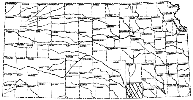
Cowley County is one of the southernmost tier of counties of the state of Kansas. (See Fig. 1.) It is one of the larger counties, being 35 miles from north to south by 34 1/2 miles from east to west. It is traversed by several railroad lines--two branch lines of the Atchison, Topeka & Santa Fe Railway, the St. Louis-San Francisco Railway, the Midland Valley Railroad, and the Missouri Pacific Railroad. The county is crossed by a number of well-graded dirt roads, which are shown on Plate I. A paved highway extends northward through Arkansas City from the state line to a point several miles beyond the city limits. The two largest towns are Arkansas City, which has a population of 12,000 and ranks fifteenth among the cities of the state, and Winfield, which has a population of 10,000 and ranks nineteenth (Mohler, 1923). The total population of the county is 37,000. The chief occupation is agriculture. Dairy products, alfalfa hay, live stock, winter wheat, corn, oats and kafir are the principal farm products. The operation of stone quarries and gravel pits and the oil industry, including refineries and gasoline absorption plants, furnish employment for an appreciable proportion of the inhabitants.
Figure 1--Index map of Kansas, showing the location of Cowley County.
Most of the surface of Cowley County is covered by a good stand of native grasses and is used for the grazing of stock, principally cattle. The eastern part of the county, particularly the Flint Hills region, is used almost entirely for grazing. The broad bottom lands of Arkansas and Walnut rivers and the narrower stretches along Dutch, Timber, Silver and Grouse creeks are used for cultivated farm crops, such as alfalfa, corn, sorghums, wheat and truck. Extensive areas of the uplands in the central part of the county are farmed, but the crops sometimes fail, particularly in tracts where the soil directly overlies limestone. Back from the rocky edges of the uplands, where the soil overlies shale of the next higher formation, crops withstand a summer drought more successfully. The degrees of success attained in raising cultivated crops on various types of soil in the county exhibit a remarkable parallelism with the geology. The later part of the summer of 1926 was exceedingly dry in Cowley County, and it was possible to outline the general areas of crop failures from the geologic map. For instance, in the east-central part of the county there is a wide strip of upland near the outcropping edge of the Wreford limestone where erosion has stripped most of the overlying Matfield shale from the limestone beds and only a thin soil covers the rocks. Throughout this strip the growing crops were the first to suffer from the lack of rainfall. The upland bordering this area on the west is underlain by the lower part of the Matfield shale, and the growing crops there withstood remarkably well the long period of drought. Crops that were growing on the bottom lands along the streams, of course, withstood the dry weather much longer than those on either of these types of upland.
General Surface Features of Kansas
The surface of Kansas is characterized by broad expanses of almost level uplands that trend slightly east of north and west of south across the state, and rise in steplike succession progressively westward. The extreme southeastern part of the state has a nearly level lowland surface; from this lowland westward to the western part of Cowley County the surface consists of a series of benches like great steps with abrupt slopes facing eastward, each bench surface tilted gently westward to the foot of the steep slope of the succeeding step. West of this area is an extensive plain occupying western Cowley County, Sumner and Sedgwick counties, western Butler and Harvey counties and some adjacent areas, and thence becoming narrower toward the north. An area about 100 miles wide from east to west having a surface similar to the benched area of eastern Kansas borders this plain on the west; still farther west, and extending for long distances into Colorado, Nebraska, Oklahoma and Texas is a broad, practically level area known as the High Plains. In a relatively small area in the south-central part of the state the surface is deeply dissected.
Probably the most rugged surface feature of Kansas is a range of hills that trends a little west of south across the state and into the northern part of Oklahoma, situated near the western edge of the benched area of eastern Kansas. Early writers in Kansas referred to these hills as the Kansas Mountains, but they later became known as the Flint Hills. They cross the easternmost part of Cowley County. Their existence is due to the abundant occurrence of chert (often called flint) in some of the limestone beds that crop out at the surface. The chert is much more resistant than the limestone and shale beds that make up the other strata of the region; consequently erosion destroys the limestone and shale more rapidly than the chert beds. The inevitable result is the formation of broad benches or uplands floored by the resistant rock and bordered by steep slopes of the softer beds. The upland surfaces slope gently westward, because the rock layers that form their floors are tilted slightly to the west. This same process has produced the steplike surface that characterizes so much of the state; in the Flint Hills region the addition of chert to the limestone has merely accentuated the resistance of the hard layers and likewise magnified the results. The Flint Hills present an eastward-facing steep slope 200 feet or more high, capped by the chert-bearing layers. The slope is not everywhere one great step, but more commonly two to three closely spaced steps or shoulders, the intervening slopes rising with steep gradients to the highest bench, which everywhere forms a broad upland. As a traveler approaches from the west the ascent toward the east is so gradual that it is not perceptible, and he comes abruptly and without warning upon the eastern edge of the upland. To the traveler approaching from the east, however, the Flint Hills stand out prominently, and he is struck by their pronounced relief. The upland surface is not everywhere floored by the same formation. In the central Kansas Flint Hills region the Florence flint provides the capping rock layers, as is finely exhibited on the Eureka-El Dorado highway a few miles east of Rosalia in eastern Butler County; farther south, throughout much of Cowley County, even the Florence flint has been removed by erosion, and the Wreford limestone, which also contains much chert and lies 60 feet beneath the Florence flint, remains to form the principal upland and rim of the Flint Hills; still farther south in Cowley County, near the Kansas-Oklahoma boundary, the chief bench has dropped down to the Foraker limestone, which lies about 300 feet beneath the Wreford.
Surface Features of Cowley County
Cowley County is so situated that it embraces parts of several of the state's physiographic divisions. The eastern part of the county includes a portion of the Flint Hills; the central part is occupied by the typical step like surface; and the westernmost sixth embraces the eastern part of the central Kansas plains.
The surface features of Cowley County are directly and almost entirely attributable to the variations in types of rock that crop out. The entire county except the extreme western tier of townships is occupied by outcropping layers of alternating limestone and shale. The limestone beds, which are more resistant to erosion than the shale beds, form the benches, and the shale beds, which are relatively soft and are readily disintegrated, form the steep eastward-facing slopes between the limestone ledges. The western sixth of the county is underlain by soft clay shale, which is readily broken down by the agencies of weathering and forms an almost level surface.
Reference to the columnar section and geologic map, both on Plate I, will show the close relationship between the surface features of the county and the outcropping strata. The Emporia limestone and the sandstone beneath it form a rock terrace along the highway near Cedarvale, Chautauqua County, about two miles east of the eastern boundary of Cowley County, and extend westward nearly to the county boundary in T. 34 S., R 8 E. In the southeastern-most part of the county the Admire shale, composed of relatively soft rocks, forms the steep eastward-facing slope of the Flint Hills, which are capped by the resistant cherty Foraker limestone, and the alternately hard and soft beds above the Foraker form low rock terraces ascending westward. In the northeastern part of the county the rim of the Flint Hills is formed by the Wreford limestone, and the several limestone units in the shale beds below form shoulders in the eastward-facing slope. The Foraker is the most prominent of these limestones and constitutes a definite subsidiary step in the Flint Hills throughout much of the region. Westward from the Flint Hills are the several step like terraces or benches formed by the beds of limestone succeeding the Wreford, of which the Herington limestone forms the topmost step. The intervening slopes are made by the softer shale formations. The area west of the crop line of the Herington is a nearly level plain carved in the soft shale beds of the Wellington formation.
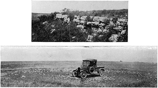
Although not so intricately dissected as the Wreford upland (see Pl. I) the area floored by the Florence flint and Fort Riley limestone is the widest in the county, occupying most of the central part. On the surface of the eastern part of this upland are abundant fragments of residual chert derived from the Florence flint. Very shallow circular basins or filled sink holes 30 feet, more or less, in diameter are noteworthy features in the northern part of the upland floored by the uppermost beds of the Fort Riley limestone. Many of the basins are rimmed by weathered fragments of the uppermost limestone beds of the Fort Riley, and their surface contains scarcely any vegetation. Plate III is a view of one of these basins in sec. 4, T. 30 S., R. 5 E., near the northern line of the county. The Winfield limestone forms a relatively narrow bench west of Walnut river, but the flat-topped buttes capped by this formation east of the Walnut bear witness to a former much more extensive table-land. The bench formed by the Herington limestone is much less pronounced than that of the Winfield throughout most of the county; it is most prominent in the vicinity of Arkansas City.
Plate III--Upper: A part of the Foraker limestone, showing beds 15 to 20 feet above the Americus (?) member, in the NW, sec. 7, T. 34 S., R. 8 E. Lower: Upland floored by Fort Riley limestone, containing sunken basin near north quarter, comer of sec. 4, T. 30 S., R. 5 E.
The surface of Cowley County ranges in altitude above sea level from 900 feet near the southeast corner of the county, where Rock creek crosses the county boundary, to a little above 1,500 feet in the northeastern part. Much of the county has an altitude ranging between 1,150 and 1,350 feet. The most abrupt differences in altitude occur in the eastern part of the county in the Flint Hills region, where the relief is commonly as great as 300 to 350 feet in a mile.
The stream valleys vary in shape and depth with their location in the county. The streams in the Flint Hills have deep, precipitous channels lined with outcropping rock ledges, and their beds are strewn with angular fragments of limestone. The valley bottoms widen at the eastern edge of the Flint Hills, however, but are bordered by steep-sided divides that rise 300 feet above the valley floors. The channels of the small intermittent streams flowing southeastward from the vicinity of Hooser illustrate the characteristics common to the stream channels in this part of the county. There stream beds are incised in narrow boxlike channels in the upper reaches, but at the points where the streams have cut through the Foraker limestone and entered the Admire shale the valleys immediately open out, and a little farther east they widen even more and have gently sloping sides. The streams in the central part of the county have widened their valley floors somewhat, but the valley walls, although receding to a considerable distance from the stream beds, are still steep and lined with ledges of limestone and rise to heights of 50 to 150 feet. The major streams in the western part of the county flow sluggishly within broad flood plains spread upon wide, shallow valleys.
The Arkansas and the Walnut, which joins the Arkansas near Arkansas City, are the only two large streams in the county, and they are both in the western part and drain the western third. The Arkansas flows southeastward across the southwest corner of the county, and the Walnut flows almost due south. Timber creek, a tributary of the Walnut, drains much of the north-central part of the county. Grouse creek and its principal tributary, Silver creek, drain the central part and discharge into the Arkansas near the state line. The extreme eastern part of the county is drained by eastward-flowing tributaries of Caney river.
Origin of the Asymmetrical Stream Valleys
It has long been noted by many observers that streams in Kansas that flow from west to east are eroding their south banks, that the northward-facing slopes are relatively much steeper than the southward-facing slopes, and that the profiles of the interstream areas are decidedly asymmetrical, the northern slope being the shorter. These facts were observed by early workers in Kansas (Haworth, Erasmus: Kansas Univ. Geol. Survey.) and have been mentioned also in more recent state reports (Rubey and Bass, 1925, p. 10; Bass, N. W., 1926, p. 18); they were called to the writer's attention and discussed at length by W. W. Rubey while working in western Kansas in 1924. In the course of reconnaissance trips about the state; which have included parts of all counties except four or five in: the extreme northeastern part, the writer has observed this phenomenon of asymmetrical stream valleys and interstream areas. It appears to prevail so generally in eastward-flowing streams in this region that stretches in any stream course that fail to exhibit this feature are believed to be merely exceptions constituting a small percentage of the total course of the stream.
The Kansas river valley has a steep, in places precipitous, south slope and a relatively gentle north slope throughout its course eastward across Riley, Wabaunsee, Shawnee, Douglas and Johnson counties. Other streams that show this same phenomenon are Republican river between the 100th and 98th meridians in southern Nebraska; White Rock river across Jewell county; Saline river across Trego, Ellis and Russell counties; Smoky Hill river across Russell county and parts of Ellis and Ellsworth counties; Walnut creek across most of Ness and Rush counties; Arkansas river throughout parts of its course in western Kansas, but with notable exceptions through extensive parts; Medicine Lodge river in western Barber county; Fall river in Greenwood county; Cottonwood river in most of its course across Chase County; Neosho river in Coffey county; Dragoon creek, Salt creek and Osage river in Osage county; and Wakarusa creek across Douglas county. The valleys of these streams constitute simply examples of this phenomenon, which is believed to be the prevailing characteristic of practically all similarly directed streams in the region.
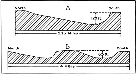
Figure 2--North-south profile of an eastward-trending stream valley near Pomona, Franklin county (above), and westward-trending valleys near Leon, Butler County (below).
The rocks in which the stream valleys are cut throughout much of the state consist of interbedded shale and limestone. A relatively small area in west-central Kansas is occupied by the Dakota sandstone, and the western third of the state is largely mantled by gravel, sand and clay beds cemented with lime carbonate. Asymmetry of cross sections prevails in valleys cut in all these rock types.
Further observations relative to stream-valley cross sections were made in the course of field work in Cowley County. Inasmuch as most of the major streams in Kansas flow eastward, most of the observations in the state have been made on eastward-flowing streams. However, Walnut river flows nearly due south, and some of its tributaries flow westward in Cowley County, thus offering new fields for observation.
Application of Ferrel's law
The fact that the right banks of the eastward-flowing streams are the steeper is in accord with Ferrel's law that all streams in the Northern Hemisphere, independent of their direction of flow, will by the influence of the rotation of the earth exert pressure on their right banks. Many of the streams on which this phenomenon was observed are small, and others intermittent and only a few miles in length--conditions under which, one would think, the influence of the rotation of the earth would be practically negligible. However, if Ferrel's law is applicable to the streams of this region, the right banks of southward- and westward-flowing streams should be steeper than the left banks. Study of Blue river, in northeastern Kansas, and of Walnut and Verdigris rivers and the lower part of the Neosho, in the southeastern part of the state, as shown on the topographic maps of the United States Geological Survey, shows that in general the east (left) slope is as steep as the west (right) slope. Westward-flowing tributaries of Walnut river were observed in Cowley County and southern Butler County in the field and on the topographic maps. The south (left) slope of these tributaries is as markedly steep and the north (right) slope as contrastingly gentle as in the eastward-flowing streams. Timber creek in north-central Cowley County is an example. It flows slightly south of west for 12 to 15 miles, passing near Floral, and practically throughout its course bluffs of Fort Riley limestone and Florence flint border its valley on the south, and relatively gentle slopes rise northward from the valley floor. Numerous short westward-flowing tributaries of Grouse creek in northeastern Cowley County exhibit like conditions, notably Cedar creek, south and southeast of Cambridge. Rock creek flows nearly due west throughout a distance of 5 miles in T. 29 S., R. 5 E., just north of the Cowley County boundary, and has produced the same result. Other tributaries of Walnut river farther north in Butler County have asymmetrical valleys similar to those just described. A noteworthy example is Hickory creek, a tributary of Little Walnut creek. It flows nearly due west for more than 15 miles in southern Butler County, about 10 miles north of the northern boundary of Cowley County, and maintains a steep northward-facing slope and more gentle southward-facing slope throughout most of its course. It appears, then, that the slope on the south side is the steeper in eastward-flowing and westward-flowing streams; in one group it is the right bank and in the other the left bank; in southward-flowing streams no marked difference in degree of slope exists. In the light of these data the conclusion that the principle of Ferrel's law is inapplicable to the stream valleys of this region is inevitable.
Migration of streams down the dip
In regions of steeply tilted strata streams often migrate down the dip, and in consequence gentle slopes prevail on the up-dip side, but in this region the departure of the strata from horizontality is extremely slight, rarely exceeding 100 feet in a mile and commonly being much less, and it is thought that this factor probably exerts but little effect upon the stream's action. Moreover, in western Kansas the rocks dip at a low angle northward, but the streams are crowding southward; in eastern Kansas the regional dip of the strata is westward, and the stream channels are migrating southward. In parts of western Kansas there are streams with channels cut wholly in flat-lying rocks of Tertiary age, and yet they exhibit asymmetrical valley cross sections similar to those of the stream valleys cut in the older stratified rocks. In places the contact of an eastward- or westward-flowing stream with tilted hard layers may have modified somewhat its course and tended to push the stream to the north rather than the south side of its valley. A case in point is Cottonwood river where it crosses an anticlinal fold near Cottonwood Falls and Strong City, in Chase County. In other localities, however, the streams follow their normal habit irrespective of minor folds in the strata. Polecat creek, in northwestern Cowley County, flows southeastward across the axis of the granite ridge over which the beds are greatly folded, but the southwest slope of the stream valley is markedly steeper than the northeast slope. A similar condition is present along Slate creek in southwestern Sumner County. However, the surface rocks of the two are as just mentioned are softer and their dips probably more gentle than in the Cottonwood Falls region. In summary, it appears that any influence that the dip of the surface strata has upon the habit of the streams is only local, and that the prevailing characteristics of the stream valleys are independent of this factor.
Southward tilting
A regional southward tilting subsequent to the time of formation of the present drainage system might tend to shift the streams southward and create the asymmetrical conditions that now exist in the channels of eastward- and westward-flowing streams. If southward tilting has occurred, streams that flow southward should show an increase in gradient and in downward cutting. These items have been given but little study. Very small gulches in Cowley County, that must be relatively young and that contain water only at times of rainfall, exhibit a marked contrast in steepness between north and south slopes, a fact that is difficult to explain by regional tilting, because of the extreme youth of the valleys. Although the little information at hand is insufficient to prove or disprove whether the region has been subjected to southward tilting, the meager facts cited contribute some evidence against the effects to be expected if such tilting had occurred.
Climatic factors
Certain climatic factors, not confined to Kansas but operating throughout this general region, appear to be ample to bring about the results observed. It is a well-known fact that in the Northern Hemisphere the southward-facing slopes are struck more directly by the sun's rays and consequently receive an appreciably greater amount of heat than the northward-facing slopes. The prevailing winds throughout the warm months are southerly in this region, and so strike the southward-facing slopes more directly than the northward-facing slopes. According to the state meteorologist's records (Flora, 1917), these winds are commonly hot and dry, often "like the wind from a furnace, in extreme cases having been known to kill the bark and foliage on the south side of trees." Both of these factors--heat from the sun's rays and heat and absorption of moisture by the winds--tend to dry out the surface material of the southward-facing slopes more than that of the northward-facing slopes. In dry-farming areas, where the precipitation is so small that success or failure in the raising of crops depends almost wholly on the degree of success in retaining the little moisture received, experienced farmers have long known that the raising of successful crops is more certain on the northward-facing slopes.
Chemical action is accelerated by an increase of heat and retarded by decrease of moisture. The heating effect of the sun's rays during the warm months would operate to hasten the chemical processes that tend to destroy the rocks, but the drying of the surface materials would retard them. Both of these factors are accentuated on the southward-facing slopes. Inasmuch as the northward-facing slopes remain relatively moist, chemical action should be almost continuous there throughout the warm period of each year. During the winter the material on the northward-facing slopes remains frozen for months at a time, while that of the opposite slope is subjected to daily thaws throughout much of the period. Accordingly, chemical action would be greater on the southward-facing slopes during the cold season. No data as to the relative effects of chemical activity are available, and it is not known whether the total effect is more destructive on the north or the south slopes.
The more direct rays of the sun on the southward-facing slopes, however, bring about a notable physical effect. The daily range of temperature is much greater on the southward-facing slopes than on the opposite slopes. The physical disintegration of the rocks due to the repeated expansion and contraction resulting from cooling and heating, freezing and thawing, would consequently be more manifest on the southward facing slopes. Moreover, the high southerly winds of the summer not only raise the temperature and dry out the surface, but as they are often laden with sand and silt, they constitute an erosional agent that accomplishes more rock destruction on the southward-facing slopes, against which they blow directly, than on the northward-facing slopes, which are comparatively protected. Relatively strong northerly winds occur during the winter throughout much of the state, but at that time the surface material is frozen and but little abrasive material can be gathered.
The season in which most of the rainfall comes may be of some importance. This region receives its maximum precipitation, approximately three-fourths of the year's total, between April and September, which is the hot portion of the year. The rain falls on south and north slopes alike, and in itself may not have a direct effect in producing asymmetrical valleys, but its maximum fall during the time of the year when the surface materials are so frequently dried by the sun's heat and loosened by the high winds is thought to be significant, inasmuch as the run-off resulting from the rainfall removes the loosened material, thus exposing new rock surfaces to the destructive elements. Moreover, the relative sparseness of vegetation on the southward-facing slopes contrasted with that on the northward-facing slopes is of no little importance, inasmuch as plant roots serve to hold the soils, and the foliage forms a protective covering. The erosional effect of the surface run-off resulting from rainfall is therefore greater on the southward-facing than on the northward-facing slopes.
To summarize, it appears that the combined effect of the several climatic factors described may produce the asymmetrical cross sections in eastward or westward trending valleys and in valleys that have a pronounced east or west component in their trends. On eastward- or westward-facing slopes the combined effect of these several climatic factors should be more or less equalized, so that no pronounced difference in degree of slope of the valley walls should result.
It may be assumed that the beds of eastward- or westward-flowing streams, except for vertical cutting, remain fixed, and that the asymmetrical slope of their valleys is produced solely by the more rapid disintegration and removal of the material extending a considerable distance back on the north side of the stream. Probably this explanation accounts for the greater part of the operating process, but it is believed also that the streams actually migrate southward. It seems that this migration should result from the accumulation and consequent building out that should take place on the gently sloping north banks, over which move greater amounts of sediment than that of the south banks. It is true that the streams will carry away much of the material that is received by tributary streams and rivulets, but in times of moderate precipitation much of the incoming sediment would be temporarily deposited near shore upon entering the quieter water of the larger streams. Inasmuch as more material is brought in from the north sides than the south, the north banks would be built out into the stream, thus forcing the currents southward, resulting in greater erosion by undercutting on the south banks, which in turn would aid in maintaining steep slopes on the south sides.
Summary
Eastward- and westward-flowing streams in Kansas have asymmetrical valley cross sections, steep on the northward-facing and gentle on the southward-facing slopes. Northward- and southward-flowing streams have symmetrical valley cross sections. The evidence observed indicates that the influence of the rotation of the earth, a possible regional tilting, or the influence of the attitude of the strata fails to account fully for the phenomenon. A combination of climatic factors with the nature of the surface strata is believed to account for the more rapid tearing down and removal of material from the southward-facing slopes than from the northward-facing slopes, which in turn results in the deposition of more material on the north than the south banks, thus forcing the currents southward.
Prev Page--Introduction || Next Page--Stratigraphy
Kansas Geological Survey, Geology
Placed on web Jan. 5, 2016; originally published May 15, 1929.
Comments to webadmin@kgs.ku.edu
The URL for this page is http://www.kgs.ku.edu/Publications/Bulletins/12/03_geog.html