Kansas Geological Survey, Open-file Report 2017-49
KGS Open File Report 2017-49
October 9, 2017
Funded by the U.S. Geological Survey, Grant G16AC00363, 10/01/2016 to 09/30/2017
The National Ground-water Monitoring Network (NGWMN) is an effort lead by the U.S. Geological Survey (USGS) to establish a network of selected monitoring wells across the country to facilitate the planning and management of groundwater resources. The NGWMN serves as a single data portal that retrieves, in real time, construction, lithology, depth-to-water measurements, and water-quality data that are maintained and served to the portal from a variety of participating local, state, and federal sources. The NGWMN can be accessed at the following URL: http://cida.usgs.gov/ngwmn/.
In 2016, the USGS provided funding support through Cooperative Agreement G16AC00017 to the Kansas Geological Survey (KGS) to become a data provider to the NGWMN. Under this agreement, the KGS evaluated monitoring sites for inclusion in the NGWMN, worked with USGS staff to populate the data portal with monitoring well sites that met a set of minimum data standards, and then developed a series of web services that allowed the NGWMN real-time data access to the state's well construction, lithology, and depth-to-water measurements records.
In 2017, the USGS continued funding support to the KGS through Cooperative Agreement G16AC00363 to maintain persistent data services to the NGWMN. This includes preserving existing web services and applying routine updates to existing network sites, which includes removing well sites that are no longer viable and uploading replacement and new well site locations.
The project period covered the 2017 federal fiscal year.
OFR 2017-49 (Adobe Acrobat, 1.4 MB)
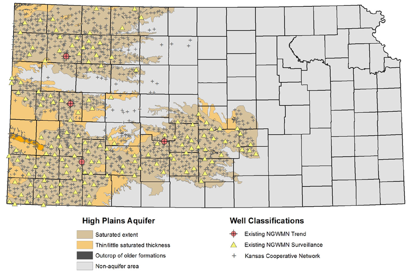
The NGWMN started serving Kansas-based groundwater data in September 2016 from 133 surveillance wells, those that are typically measured annually during the winter months, and 4 trend wells, which are true observation wells that record water levels in real time throughout the year and across seasons (fig. 1). All of these well sites are part of the larger Kansas Cooperative Water-Level Network, a collection of approximately 1,400 wells measured annually by the KGS in cooperation with the Kansas Department of Agriculture, Division of Water Resources (Miller et al., 1998).
The vast majority of measurements take place in the month of January, typically in irrigation wells using steel or electric tapes, which have precisions down to hundredths of a foot. Customized software developed by the KGS and global positioning systems are used to ensure the same wells are measured each year and to conduct on-site data validations of depth-to- water measurements. Additional statistical and GIS reviews are conducted later to identify abnormal or anomalous measurements. If necessary, well sites are re-measured the same day or within a month, depending on the circumstances.
Figure 1—Kansas cooperative network and participating 2016 High Plains Aquifer NGWMN sites.
The Kansas Cooperative Network also consists of a growing collection of continuously monitored wells. Referred to as "index wells," these sites are equipped with pressure transducers that record water levels every hour and, through the use of telemetry systems, provide real-time access to water-level data throughout the year (Butler et al., 2017). Index wells are also manually measured throughout the calendar year, typically every three to four months.
Depth-to-water measurements are stored in an Oracle-based enterprise-level relational database (RDMS) called the Water Information Storage and Retrieval Database (WIZARD). WIZARD evolved from the U.S. Geological Survey's Ground Water Site Inventory in the mid- 1990s (Hausberger et al., 1998) and today represents the largest repository of depth-to-water measurements in Kansas. Measured well sites are used to track temporal changes in water table elevations and estimates of water availability. WIZARD currently consists of more than 57,000 well sites with more than 600,000 water-level measurements. Data can be accessed at the following URL:
http://www.kgs.ku.edu/Magellan/WaterLevels/index.html
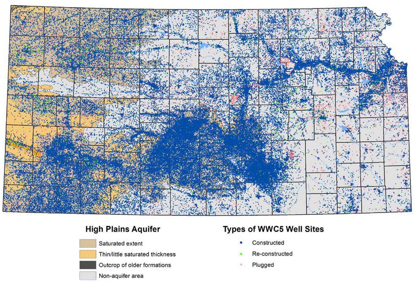
A key feature to the NGWMN data framework is that participating wells must have associated construction and lithology descriptions. In Kansas, this information can be obtained from the Water Well Completion Records Database (WWC5). Since the mid-1970s, water well drilling companies have been required to provide location, type, use, casing, lithology, and other information to the Kansas Department of Health and Environment any time a well is constructed, re-constructed, or plugged. The KGS stores more than 276,000 WWC5 records (fig. 2) in an Oracle RDMS and serves these data to the public through the following URL:
http://www.kgs.ku.edu/Magellan/WaterWell/index.html
Figure 2—WWC5 well sites.
Data are streamed to the NGWMN through a series of web services, standardized protocols by which data are transmitted and shared across the internet. The Kansas web services were developed as a single Adobe ColdFusion component, stored on a replicated computer cluster that distributes workloads between two Apache web servers. The ColdFusion component has four methods, one representing each service (e.g., water levels, lithology, screens, and casings), supports REST protocol, and returns XML-formatted web documents.
Each of the four methods provided under the Kansas web service is called using a URL-based variable along with a list of one or more site IDs for NGWMN wells. A list of the methods for an example well is shown below, and more descriptions of each process can be found in the report "Establishing Kansas as a Data Provider to the National Groundwater Monitoring Network" (Wilson, 2016).
Existing Kansas NGWMN well sites were reviewed to make any necessary changes to a site's participation status with the program. The KGS checked results from the 2017 water-level measurement campaign for the NGWMN wells to make sure the sites were still measurable and to determine whether the annual change in the water table was representative of aquifer conditions for given areas. In addition, the KGS conducted a more detailed review of the WWC5 classifications to look for cases of missing/incomplete lithology descriptions or situations in which the well record was listed as a constructed well when the submitted form was actually a plugging report. Table 1 lists wells that were dropped from the NGWMN data portal in 2017, the reason for removal, and whether the well was replaced.
Table 1—Kansas Wells Removed in 2017 From the NGWMN Data Portal
| Site Number | Legal Description | Reason for Removal |
|---|---|---|
| 380135100081001 | 23S 26W 26AAD | Pump re-worked, no access. |
| 374143098124601 | 27S 08W 17DAB | Well plugged. Replaced with 374143098124602 |
| 370014101211601 | 35S 37W 16BCC | Well plugged. Replaced with 370014101211602 |
| 374951101144601 | 25S 36W 35CCA | Well modified and measuring point is blocked. |
| 391824101383601 | 09S 39W 02BAB | Only down-hole access is the actual pump column. |
| 390336100330001 | 11S 29W 33BBA | Incomplete or missing lithology. |
| 393127100490701 | 06S 31W 19ABA | Incomplete or missing lithology. |
| 380036098355801 | 23S 12W 36BBC | Incomplete or missing lithology. |
Additional wells from the Kansas Cooperative Network were reviewed for inclusion in the NGWMN to enhance distribution and increase the number of wells involved in the program. Sites were selected based on their spatial distribution relative to current participating wells along with the minimum data standards of an established annual measurement history of at least five years and the availability of WWC5 driller logs containing construction, screening, and lithology information.
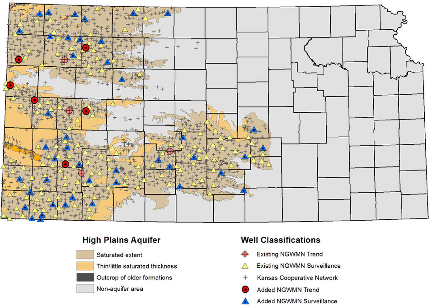
The Kansas Index Well Program was expanded in 2016 with the construction of four new observation wells across west-central and northwest Kansas and outfitting of, two existing wells of the necessary equipment to provide continuous, real-time water-level data. These six sites were selected and classified as trend wells in the NGWMN system. An additional 44 wells were selected and identified as surveillance wells based on their annual measurement frequencies for a total of 50 additional NGWMN Kansas sites added in 2017. All of these sites are located in areas that have active groundwater pumping (Fross et al., 2012; Whittemore et al., 2016) and therefore have been designated as part of the "Documented Changes" subnetwork of the NGWMN.
As of the date of this report, a total of 191 wells are served from the KGS to the NGWMN system; of those, 181 are surveillance wells and 10 are trend wells (fig. 3).
Figure 3—Participating KGS-based NGWMN wells in 2017.
The additional 2017 well sites were further used to help test a beta version of a bulk well site loader for the NGWMN Well Registry. In previous versions of the NGWMN data portal, wells had to be loaded manually, attribute by attribute, which could be a time-intensive process depending on the number of records involved. The new bulk load function allows well records to be listed first in a standardized spreadsheet, which is then uploaded to the NGWMN Well Registry. This greatly increases the efficiency by which wells can be registered in the system.
Finally, the "WaterLevels" method providing data to the Kansas NGWMN web service was modified to account for the six new trend wells added in 2017. Every Kansas index well has a unique setup in terms of casing height, down-hole depth of the pressure transducer, and the process by which data are remotely transmitted. Consequently, data are stored in a variety of internal tables within the KGS database. The web service was updated accordingly to retrieve correct information for the new wells.
The KGS has entered into a third grant and cooperative agreement with the USGS. This project will work to continue to maintain the Kansas-based web services to the NGWMN, making any needed changes and well additions after the Kansas Cooperative Network measurements are made in the winter of 2018. In addition, this new project funds the installation of five trend wells in the Kansas River alluvial aquifer, a stream valley in Kansas with major population growth and economic activity that lacks an active water-level observation network at the state level.
The author acknowledges and is grateful for the funding and project support of the USGS, specifically Daryll Pope and Jessica Lucido for their assistance, counsel, and review of this project; Keith Hunsinger for his guidance on web service development; Dana Adkins-Heljeson for all his data efforts, especially taking WWC5 forms from images to database-accessible records; and Julie Tollefson, KGS editor, and Geoff Bohling, KGS Geohydrology Section, who reviewed this final report.
The Kansas Geological Survey does not guarantee this document to be free from errors or inaccuracies and disclaims any responsibility or liability for interpretations based on data used in the production of this document or decisions based thereon. The views and conclusions contained in this document are those of the authors and should not be interpreted as representing the opinions or policies of the U.S. Geological Survey. Mention of trade names or commercial products does not constitute their endorsement by the U.S. Geological Survey.
Butler, J. J., Jr., Whittemore, D. O., Reboulet, E., Knobbe, S., Wilson, B. B., and Bohling, G. C., 2017, High Plains Aquifer Index Well Program: 2016 Annual Report: Kansas Geological Survey, Open-file Report 2017-10, 156 p. [available online]
Fross, D., Sophocleous, M., Wilson, B. B., and Butler, J. J., Jr., 2012, Kansas High Plains Aquifer Atlas: Kansas Geological Survey, http://www.kgs.ku.edu/HighPlains/HPA_Atlas/index.html (accessed October 20, 2016).
Hausberger, G., Davis, J., Miller R., Look, K., Adkins-Heljeson, D., Ross, G., Bennet, B., Schloss, J., and Bohling, G., 1998, WISARD: Water Information Storage and Retrieval Database: Kansas Geological Survey, Open-file Report 1998-13, 42 p.
Miller, R. D., Buchanan, R. C., and Brosius, L., 1998, Measuring water levels in Kansas: Kansas Geological Survey, Public Information Circular 12, 4 p. [available online]
Whittemore, D. O, Butler, J. J., Jr., and Wilson, B. B., 2016, Assessing the major drivers of water level declines: New insights into the future of heavily stressed aquifers: Hydrological Science Journal, v. 61, no. 1, p. 134-145, doi: 10.1080/02626667.2014.959958.
Wilson, B. B., 2016, Establishing Kansas as a Data Provider to the National Ground-water Monitoring Network: Kansas Geological Survey, Open-file Report 2016-28, 12 p. [available online]
Kansas Geological Survey, Geohydrology
Placed online Dec. 13, 2017
Comments to webadmin@kgs.ku.edu
The URL for this page is http://www.kgs.ku.edu/Hydro/Publications/2017/OFR17_49/index.html