Kansas Geological Survey, Open-file Report 2016-28
KGS Open File Report 2016-28
November 8, 2016
Funded by the U.S. Geological Survey, Grant G16AC00017, 01/01/2016 to 12/31/2016
The National Ground-water Monitoring Network (NGWMN) is an effort lead by the U.S. Geological Survey (USGS) to establish a network of selected monitoring wells across the country to facilitate the planning and management of groundwater resources. The NGWMN serves as a single data portal that retrieves, in real time, construction, lithology, depth-to-water measurements, and water-quality data that are maintained and served to the portal from a variety of participating local, state, and federal sources. The NGWMN can be accessed at the following URL: http://cida.usgs.gov/ngwmn/.
In 2016, the USGS provided funding support through Cooperative Agreement G16AC00017 to the Kansas Geological Survey (KGS) to become a data provider to the NGWMN. Under this agreement, the KGS evaluated monitoring sites for inclusion in the NGWMN, worked with USGS staff to populate the data portal with monitoring well sites that met a set of minimum data standards, and then developed a series of web services that allowed the NGWMN real-time data access to the state's well construction, lithology, and depth-to-water measurements records.
The project period covered the 2016 calendar year. The NGWMN started serving Kansas-based groundwater data in September 2016. This final report was written in November 2016.
OFR 2016-28 (Adobe Acrobat, 1 MB)
The KGS administers two principle groundwater well inventories used in this project that address water levels and well construction: the Water Information Storage and Retrieval Database (WIZARD) and the Water Well Completion Records Database (WWC5). Both datasets are stored natively in Oracle, an enterprise-level relational database management system.
WIZARD evolved from the U.S. Geological Survey's Ground Water Site Inventory in the mid- 1990s (Hausberger et al., 1998) and today represents the largest repository of depth-to-water measurements in Kansas. Well sites are used to track temporal changes in water table elevations and estimates of water availability. The KGS works in cooperation with the Kansas Department of Agriculture, Division of Water Resources (KDA-DWR) to annually measure approximately 1,400 wells as part of the Kansas Cooperative Water-Level Network (Miller et al., 1998). The majority of sites are production wells, typically irrigation wells. Additional water levels, measured semi-annually and quarterly, are routinely submitted to WIZARD from other state and local groundwater management district networks.
Most of the Kansas Cooperative Network sites are located in the High Plains aquifer region of Kansas, the western third and portions of south-central of the state (fig. 1), and are measured primarily in the month of January. Customized software developed by the KGS, coupled with global positioning systems, is used to make sure the same wells are visited each year. Wells are measured manually using steel or electric tapes, both having precisions down to the hundredth of a foot. Measurements are field checked on site at the time of the visit to insure locational accuracy and that the current measurement is within the historical trend of past measurements. Additional statistical and GIS reviews are conducted later to identify abnormal or anomalous measurements, which are flagged in the database accordingly. If deemed necessary, well sites will be re-measured the same day or within a month, depending on the circumstances.
Figure 1--Map of the High Plains aquifer extent in Kansas and WIZARD well sites.
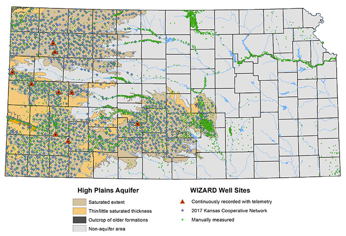
In addition to manual water-level measurement, the WIZARD database incorporates a collection of continuously monitored wells (water levels recorded every hour) equipped with telemetry systems that provide real-time access to water-level data throughout the year. In Kansas, these continuously measured wells are referred to as "Index Wells" (Butler et al., 2016).
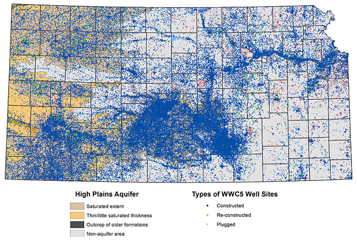
The WWC5 database is the state's most comprehensive, single collection of groundwater well records across the entire state containing information submitted by water well drillers to the Kansas Department of Health and Environment. Starting in the mid-1970s, drilling companies were mandated by state legislation to provide information about the location, type, use, casing, lithology, and other specifications for every well that is constructed, re-constructed, or plugged in Kansas (fig. 2). The KGS is charged by statute to store and serve these data to the public. Data are used to track groundwater development and categorize the lithologic descriptions into common groups from which aquifer properties such as hydraulic conductivities and specific yields can be better estimated.Figure 2--WWC5 well sites.
WIZARD and WWC5 are maintained independently of each other, and each has its own web-based data portal (http://www.kgs.ku.edu/Magellan/WaterLevels/index.html and http://www.kgs.ku.edu/Magellan/WaterWell/index.html. respectively). Through an effort funded by the Kansas Water Plan, referred to as the Kansas Master Well Inventory, the data sets have been cross-referenced with each other (along with other groundwater inventories) to allow seamless data integration between the data sets. In terms of water quality, Kansas does not have an active groundwater quality network or a developed database schema.
The goal of the NGWMN is not to replace local groundwater monitoring networks but rather to look at long-term trends across regional or national scales from a selected set of wells. The data providers select which wells from their own data inventories should participate in the NGWMN. The USGS has established minimum data requirements for well sites selected to participate in the program and provides recommended characteristics by which wells are categorized as "trend" or "surveillance" wells.
Trend wells are true observation wells. They are typically fewer in number within a network but collect data at more frequent intervals to track water levels through the year and across seasons. Well sites in the Kansas Index Well Program meet these requirements as each is equipped with a down-hole sensor to continuously record hourly water levels and telemetry systems that provide near real-time access (within four hours). At the start of this project, Kansas had four operational index wells sites that were selected to be trend wells in the NGWMN (fig. 3). Over the summer months of 2016, three additional index well sites were drilled and another two existing observation wells were equipped with pressure transducers and telemetry units. These additional index well sites will be included in the NGWMN in calendar year 2017.
Figure 3--WIZARD/WWC5 well sites selected for the NGWMN.

Surveillance wells, by NGWMN definition, measure the water table less frequently than trend wells, but they are found in greater numbers within a network. The Kansas Cooperative Network is composed primarily of surveillance wells in that measurements are taken annually, primarily in the winter month of January, and the wells are spatially distributed across the entire extent of the Kansas High Plains aquifer region. The same set of wells is targeted to be measured to track long-term changes in the water table. Numerous sites have measurement histories going back to the 1960s and earlier. Invariably, some wells are unable to be measured and wells are added and dropped from the network each year. The Kansas Cooperative Network typically contains about 1,400 wells.
Kansas Cooperative Network wells were reviewed for sites that were 1) measured in the winter months every year since 2012 and 2) had matching WWC5 well records, indicating the availability of construction and lithologic data for the site. The wells were further selected subjectively to provide a uniform distribution across the Kansas High Plains aquifer region. A total of 133 Kansas Cooperative Network wells were selected as surveillance wells and linked to the NGWMN (fig. 3).
The NGWMN further classifies participating monitoring wells into the following subnetworks: Background (little or no documented anthropogenic effect), Suspected (suspected or anticipated anthropogenic effects), or Documented (known anthropogenic effects). Groundwater development and water-level changes in Kansas have been well documented over time (Fross et al., 2012; Whittemore et al., 2016), so all of the 137 Kansas wells (surveillance and trend) were designated as being in the "Documented Changes" subnetwork for the NGWMN.
Data are streamed to the NGWMN by the cooperating agencies through web services, a standardized protocol by which data are transmitted and shared across the internet. For this project, a web service is queried by submitting a URL-based request for a given ID number of a well already selected to participate in the NGWMN. The web service, in turn, queries the KGS-based databases in real time and returns water-level measurements, lithology, construction data, and screening intervals data records as an XML-formatted document. Because all the XML streams follow the same minimum data standards and structure, the NGWMN is able to merge information from multiple sources and return the information to its users as a single data set.
The Kansas web services were developed as a single Adobe Coldfusion component, stored on a replicated computer cluster that distributes workloads between two Apache web servers. The Coldfusion component has four methods, one representing each service (e.g., water levels, lithology, screens, and casings), supports REST protocol, and returns XML-formatted web documents.
The different methods for the Kansas web services are specified using URL-based variables along with a list of one or more site IDs for the designated NGWMN wells. The IDs of multiple wells should be separated by commas.
Water levels for a particular site can be retrieved from the Kansas web service by specifying the "WaterLevels" method. For example:
http://maps.kgs.ku.edu/geohydro/wizard/services/data.cfc?method=WaterLevels&sites=371237100455301
In the above example, for site ID 371237100455301, the web service returns an XML-formatted document listing the site ID, the site name (composed of the Public Land Survey System township, range, section, and qualifiers in which the well is located), all the depth-to-water measurements on record, the measurement date (and time, if available), the measuring agency, and how the well was measured. When a trend well is queried, the web service returns the daily average water level. Given several of the KGS index wells have records going back to 2007, only the last month of data, starting with the current day of the query, is returned.
Specifying the "Lithology" method from the Kansas web service returns all the listed lithologic material associated with the well site.
http://maps.kgs.ku.edu/geohydro/wizard/services/data.cfc?method=Lithology&sites=371237100455301
The web service provides the same site ID and site name as the "WaterLevels" method along with a unique ID number to specify the lithology interval, the observation method, the footage distance below land surface of the interval (specified as a distance "from" and "to"), and the description of the material in the interval. At the time of this report, all lithologic observations are based on WWC5 forms submitted by drilling companies.
The "Casing" method returns information about the well's casing, also referred to as the borehole.
https://maps.kgs.ku.edu/geohydro/wizard/services/data.cfc?method=Casing&sites=371237100455301
In addition to the site ID and name, this web service method returns the completion date of the well site, the footage distance below the land surface of the casing interval (specified as a distance "from" and "to"), and the material the casing is made from (steel or PVC). At the time of this report, all casing observations are based on WWC5 forms submitted by drilling companies.
The "Screens" method returns information about the well's screening interval, which is the portion of the well exposed to the aquifer that allows water to enter the well.
https://maps.kgs.ku.edu/geohydro/wizard/services/data.cfc?method=Screens&sites=371237100455301
This method returns the ID, site name, completion date, the footage distance below the land surface of the screening interval (specified as a distance "from" and "to"), and the material from which the screens are made. At the time of this report, all screen observations are based on WWC5 forms submitted by drilling companies.
The KGS has entered into a second grant and cooperative agreement with the USGS to maintain the Kansas-based web services to the NGWMN. Each year, in the month of March, a significant number of updates are made related to well locations and water-level measurements in the Kansas Cooperative Network. This new agreement will ensure those changes are reflected in the current list of sites in the NGWMN in 2017. In addition, the registry will be populated with new selected site locations that meet the minimum data requirements, specifically the new index wells that went online in the summer of 2016.
The author acknowledges and is grateful to the funding and project support of the USGS, specifically Daryll Pope and Jessica Lucido for their assistance, counsel, and review of this project; Keith Hunsinger for his guidance on web service development; Dana Adkins-Heljeson for all his data efforts, especially taking WWC5 forms from images to database-accessible records; and Julie Tollefson, KGS editor, who reviewed this final report.
The Kansas Geological Survey does not guarantee this document to be free from errors or inaccuracies and disclaims any responsibility or liability for interpretations based on data used in the production of this document or decisions based thereon. The views and conclusions contained in this document are those of the authors and should not be interpreted as representing the opinions or policies of the U.S. Geological Survey. Mention of trade names or commercial products does not constitute their endorsement by the U.S. Geological Survey.
Butler, J. J., Jr., Whittemore, D.O., Reboulet, E., Knobbe, S., Wilson, B. B., Stotler, R. L., and Bohling, G. C., 2016, High Plains Aquifer Index Well Program: 2015 Annual Report: Kansas Geological Survey, Open-file Report 2015-3, 179 p. [available online]
Fross, D., Sophocleous, M., Wilson, B. B., and Butler, J. J., Jr., 2012, Kansas High Plains Aquifer Atlas: Kansas Geological Survey, http://www.kgs.ku.edu/HighPlains/HPA_Atlas/index.html (accessed October 20, 2016).
Hausberger, G., Davis, J., Miller R., Look, K., Adkins-Heljeson, D., Ross, G., Bennet, B., Schloss, J., and Bohling, G., 1998, WIZARD: Water Information Storage and Retrieval Database: Kansas Geological Survey, Open-file Report 1998-13, 42 p.
Miller, R. D., Buchanan, R. C., and Brosius, L., 1998, Measuring water levels in Kansas: Kansas Geological Survey, Public Information Circular 12, 4 p. [available online]
Whittemore, D. O., Butler, J. J., Jr., and Wilson, B. B., 2016, Assessing the major drivers of water level declines: New insights into the future of heavily stressed aquifers: Hydrological Sciences Journal, v. 61, no. 1, p. 134-145, doi: 10.1080/02626667.2014.959958.
Kansas Geological Survey, Geohydrology
Placed online Dec. 13, 2016
Comments to webadmin@kgs.ku.edu
The URL for this page is http://www.kgs.ku.edu/Hydro/Publications/2016/OFR16_28/index.html