Kansas Geological Survey, Open-file Report 2000-60
Part of the Equus Beds Mineral Intrusion Project
Kansas Geological Survey, University of Kansas
KGS Open File Report 2000-60 (Version 2.0)
March 2001
Contents:
This report summarizes the outcomes of studies by the Kansas Geological Survey (KGS) during the last decade with regard to mineral intrusion into the aquifers of south-central Kansas, in Groundwater Management Districts (GMDs) 2 and 5.
In the western part of south-central Kansas, west of US Highway 281, deep, relatively permeable layers of Permian-age bedrock saturated with groundwater of high salinity are separated from the overlying freshwater aquifers by thick Cretaceous aquicludes. East of US Highway 281, no definite separation exists between the Permian formations and the freshwater aquifers. There, groundwater resources are threatened by mineral intrusion from the Permian bedrock into the freshwater aquifers. The aquifer system in most of the area is called the Great Bend Prairie aquifer; in the east this aquifer is continuous with the Equus Beds aquifer. Specific local areas of significance within GMD2 and GMD5 are discussed in this report:
Studies have indicated that a major potential threat to the quality of groundwater resources in the Hutchinson-Nickerson area (also known as the Equus Beds Mineral Intrusion, or EBMI, study area) originates from the migration of groundwater of low quality from south of the Arkansas River to north of the river. Oil brine and salt mine waste contamination are local threats in specific places.
Much of the salt in the groundwater south of the Arkansas River originates from mineral intrusion in the northern Stafford County and Rattlesnake Creek areas. However, a possible component of the regional threat is local penetration of saltwater from the Permian zone, due to the lack of impermeable layers separating the freshwater aquifer from the Permian zone.
The Rattlesnake Creek corridor is the major avenue for releasing significant salt quantities from the Permian zone to the land surface. Use of Rattlesnake Creek water for the survival of the wildlife refuge in the Quivira marsh area represents an innovative combination of natural phenomena with engineering ingenuity. However, dry-season streamflows are not reliably adequate for the needs of the wildlife refuge, and efforts are in progress to resolve the problems of competing demands for regionally limited water resources.
In northern Stafford County fresh groundwater resources are threatened by salinity penetration from the deepest layer of the alluvial aquifer, which is saline over much of the area, and by increasing nitrate concentrations in the shallow aquifer due to farming and land fertilization. The freshwater aquifer consists of a shallow permeable layer that is typically separated from the deeper saline aquifer by incomplete clay lenses. Water use in this region is already limited by salinity, and remaining freshwater resources are subject to an extremely high risk of loss of potable and irrigation water resources.
At present, generally good quality groundwater resources characterize the Ninnescah Basin. However, clusters of wells of comparatively high salinity, and perching saltwater springs in several locations, indicate that groundwater quality in this area is not completely safe.
Upward migration of salinity from the Permian strata is the major source of groundwater mineralization in south-central Kansas. Good connection between the saltwater-bearing formations and the freshwater aquifer enhances groundwater mineralization. In some places, like the Rattlesnake Creek corridor, natural discharge of saltwater is very effective in releasing large quantities of salt to surface flow, where it drains out of the region. However, human activities, such as high rates of groundwater pumping, can reduce surface flow and increase saltwater intrusion into the freshwater aquifer system. These anthropogenic phenomena diminish the quality of groundwater resources and cause deficits in the budget of potable water and water available for agricultural uses.
The bedrock surface below the regional aquifer is rich with paleochannels, where saltwater from Permian formations may penetrate and possibly be conveyed over large distances. There is a close relationship between the Permian zone topography and the tendency of saltwater to penetrate into the freshwater aquifer. Field observations and theoretical calculations have indicated that in cases of paleochannels parallel to the groundwater streamlines, the channels can be a major path for saltwater migration. Such a phenomenon takes place along the Rattlesnake Creek corridor, where the paleochannel course, the Rattlesnake Creek course and the groundwater streamlines are approximately parallel. The effect of the paleochannels on advection of salinity is less significant where their course is not parallel to the groundwater streamlines, but even in these cases the course of the paleochannel may preferentially include locations of saltwater penetration into the aquifer.
Some major recommendations based on the results of the KGS studies are summarized in this report. The recommendations try to provide the local and state water authorities with appropriate measures for the preservation of the groundwater resources in south-central Kansas. Some recommendations address ways to improve the quality of groundwater resources and provide increased quantities of groundwater for agricultural uses. Other recommendations address preparations for possible future needs.
A major recommendation addresses implementation of appropriate regulations and systems of groundwater monitoring. Monitoring by itself represents an alarm system. It may provide information about the state of the groundwater quality and the parameters that control the quality of the freshwater aquifers. Specific guidelines are suggested for the design and use of monitoring systems in each of the areas of south-central Kansas. Groundwater monitoring programs are mainly needed in the Hutchinson-Nickerson area and in northern Stafford County. In the Rattlesnake Creek corridor, the current monitoring activities may be sufficient if the results are assembled for overall review. In the Ninnescah Basin the quality of groundwater should be monitored in several sensitive areas.
It is strongly recommended that strict 'redlines' (critical management or regulatory action thresholds) be adopted with regard to water-table elevation and salinity concentrations in the Hutchinson-Nickerson area and in northern Stafford County. In northern Stafford County, the situation of the fresh groundwater resources is extremely delicate, and therefore redlines should also be linked to pumping rates, pumping distribution, and nitrate concentration. In the Ninnescah Basin redlines with regard to salinity should be adopted in sensitive areas.
Possible remedial measures to improve the quality of groundwater resources are reviewed in this report. Such measures might include saltwater extraction, and aquifer recharge with treated wastewater. One practical option may be to reclaim the deep aquifer in northern Stafford County, and use both shallow and deep aquifers in this area only for agricultural use. Potable water could either be imported to this area, or provided by treatment of groundwater to reduce nitrate concentrations.
In view of the abundance of low-quality water in the region and the lack of new potable water available for appropriation, use of desalination may be an option to consider in cases of increasing future needs for municipal and industrial water, mainly in urban areas.
The authors of this report advocate comprehensive planning and an integrated water resource management program for the hydrologically connected areas of south-central Kansas. Such a program should consider the long-term economic and environmental needs of the region, including all needs of the rural and urban communities, preservation of sources of livelihood, preserving the environment and wildlife refuges, improvements of the quality of groundwater resources, etc. Because the existing political and jurisdictional boundaries can have the effect of separating problems from potential solutions, some modifications of existing statutes, regulations, and agreements would be required to implement an integrated regional water management system. This would necessarily be a long-term, multilateral development; this report is intended to provide a basis for discussion of some of the issues and possibilities.
NOTE: The recommendations made in this report do not represent the official position of the Kansas Geological Survey, or of any of the agencies involved in the study. They present the professional judgment of the authors about technically feasible ways to address the issues motivating this, and prior, mineral intrusion studies in the region.
1.1 Occurrence and origins of salt contamination
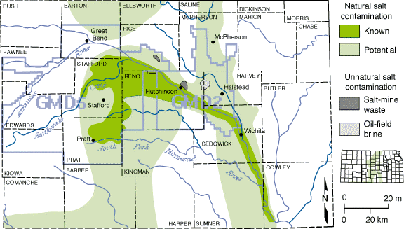
South-central Kansas contains a wide range of areas subject to groundwater contamination by naturally occurring salt deposits (see Figure 1). The region of interest includes Groundwater Management Districts (GMDs) Nos. 2 and 5, and is an area where groundwater is an important resource for agriculture and municipal water supplies.
Figure 1. Areas with known or potential saltwater contamination in south-central Kansas. Areas identified as "known" natural salt contamination have saltwater within the freshwater aquifer. In the areas labeled "potential" natural salt contamination, subsurface bedrock formations containing salt or saltwater may be in contact with the overlying freshwater aquifers. Groundwater Management District boundaries (GMD) 2 and 5 are shown (from Buddemeier et al., 1995).
The region is a natural discharge area for both freshwater from the shallow alluvially-derived aquifers, and saltwater from the deeper Permian bedrock and other formations. Salt marshes and saline streams and groundwater are natural features of the area, but there are substantial amounts of usable groundwater as well.
The Arkansas River flows through the region. Although it is a net gaining stream (and recipient of salt discharge), it provides some recharge to the aquifer during high flow periods, and the incoming water brings significant salt loads from western Kansas. The river has been traditionally considered to be an effective barrier between the extensive regions of saline groundwater on the south, and smaller areas of fresh groundwater on the north.
1.2 General problems and concerns
Although salt contamination is a natural occurrence in the area, there is concern that extensive exploitation of the fresh water resources may act to change the intrusion rates or flow patterns of the salt through alterations in groundwater head and streamflow.
Previous studies of salt intrusion in GMD5 (Buddemeier et al., 1993; Young et al., 1993; Buddemeier, 1994; Garneau et al., 1994; Young et al., 1994; Buddemeier et al, 1994a, b; Ma and Sophocleous, 1994; Buddemeier and Falk, 1994; Garneau et al., 1995; Young, 1995; Young et al., 1995a, b; Ma and Sophocleous, 1996; Quinodoz and Buddemeier, 1997;) showed that irrigation pumping can cause upconing of salt from the base of the aquifer, and that streamflow is an important factor in groundwater salt balance, since discharge to surface flow removes a disproportionately large share of the salt compared to the fraction of the water lost.
1.3 Specific issues
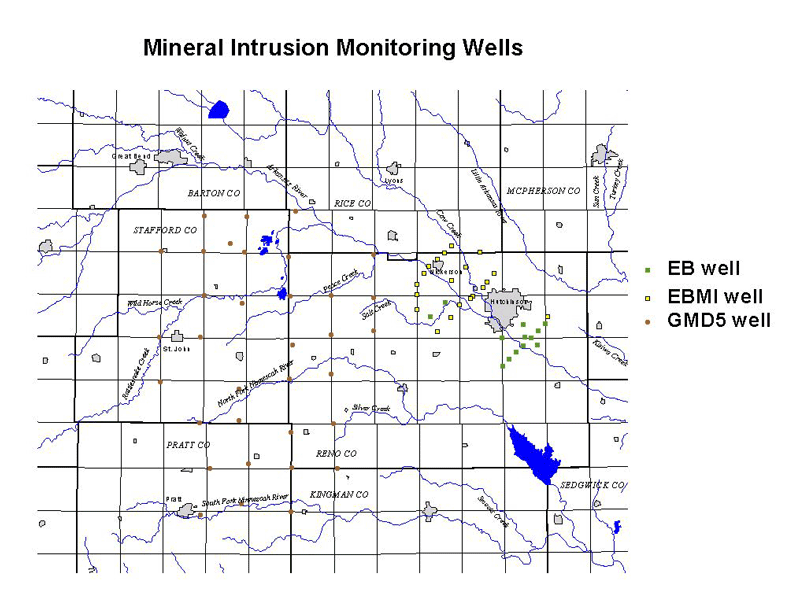
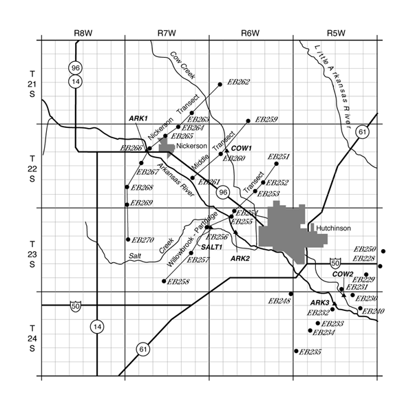
In addition to the concerns about the possible salinization of the aquifer due to long-term extraction of groundwater, specific threats to public water supplies are also an issue. The cities of Hutchinson and Nickerson, located near the Arkansas River on the north side, rely on municipal wells relatively close to the river, and are in an area also affected by agricultural and industrial pumping. A multi-agency study has addressed the question of whether these water supplies may be threatened by salt encroachment from the saline areas south of the river. As part of this study, transects of monitoring wells (the EBMI wells in Figure 2; see also Figure 5 for detail) were installed and measured within the central study region, and a model of the river corridor was developed by the U. S. Bureau of Reclamation (USBR) to test salt movement scenarios. This model is the subject of a separate report by the USBR.
1.4 Context and purpose of the report
The goal of this report is to assemble, integrate, and interpret the body of data and information assembled by the two mineral intrusion studies (GMD5 and GMD2). It uses the results of descriptive methods, correlation and budget models, and the Top-Specified Boundary Layer (TSBL) (Rubin and Buddemeier, 1996; 1997 1998a, b, c, d, e) approach to describing contaminant transport. Specific objectives include:
Figure 2. Mineral intrusion monitoring well locations in the study region. EBMI wells were installed specifically for this study; GMD5 wells originated from an earlier study in that area.
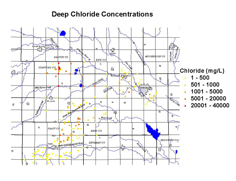
Mineral intrusion has been studied or assessed in several regions. Each region is characterized by a unique combination of the specific aspects of salinity penetration into groundwater. Figure 3 identifies locations of elevated salinity in each of the regions referred to in this section. The mechanisms of salinity penetration typical of each area have been identified, and are the basis for the recommendations developed in later sections of the report.
Figure 3. Chloride concentrations near the base of the unconsolidated aquifer. Only the lightest color indicates water that may be fully suitable for both human consumption and irrigation applications.
2.1 The Hutchinson-Nickerson region
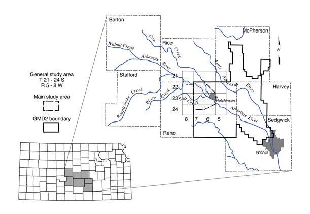
The EBMI study area is centered on the corridor between Nickerson and Hutchinson in the extended western portion of GMD2 in north-central Reno County (Figure 4). Fresh water is present in the aquifer north of the Arkansas River while saline groundwater occurs along and south of the river. The cities of Hutchinson and Nickerson obtain their water supplies from the fresh groundwater north of the river, and there is growing concern about the possible future salinization of that water source.
The case study focuses on interactions of the Arkansas River and its tributaries with the surrounding alluvial aquifer system and the Permian-age bedrock beneath the aquifer. Sources of saline water to the aquifer include groundwater transport of saline water from the northern Stafford County and Rattlesnake Creek regions to the west, local seepage of saltwater from the Permian bedrock, and surface water transport into the region by the Arkansas River.
Figure 4. Location of the Hutchinson-Nickerson area. The Equus Beds Mineral Intrusion, or EBMI, area is shown by the gridded inset at the center of the figure.
A network of 41 monitoring wells at 21 sites was installed for groundwater data collection (Young et al., 1997, 1998; see Figures 2 and 5). The wells were used primarily for monitoring water levels and water quality at different depths in the Equus Beds aquifer. In addition, logs of the wells provide information on the sediments that comprise the aquifer, the salinity distribution at the different locations, and the depth to bedrock.
Drilling began in late September 1996 and was completed in January 1997. Each site has at least one well screened in the Equus Beds aquifer. Most sites consist of two or more wells completed at different depths in the aquifer. Nearly all the sites have a deep well, the "C" well, completed directly above bedrock. Some sites have at least one well of intermediate depth in the aquifer, the "B" well. Most sites have at least one well of shallow to intermediate depth, the "A" well. And one site has four wells; the shallowest well has the designation "AA". A complete listing of sites and wells, and a tabulation of the data, is included in Kansas Geological Survey Open-file report 2000-30.
The monitoring sites were situated to form transects across the Arkansas River. An effort was made to complete some wells in alluvial material deposited in deep bedrock channels, which may be significant pathways for saltwater transport. Figure 5 shows locations of new (EB250-EB270) and existing groundwater monitoring sites in the general study area. KGS OFR 2000-30 summarizes basic well and site information, including groundwater monitoring site and well ID, legal location, land surface elevation, depth to bedrock, bedrock surface elevation, and screen and gravel pack intervals. Locations and elevations were surveyed by the U.S. Bureau of Reclamation using a global positioning system (GPS).
Figure 5. Locations of groundwater monitoring sites (solid circles) and transects and surface water data collection points (triangles) in the EBMI study area. See Figure 4 for grid location.
The aquifer is composed primarily of unconsolidated quaternary deposits of sand and gravel interbedded with layers or lenses of silt and clay; the thickness and character of the materials is variable. Generally, the aquifer overlies bedrock of Permian age, however bedrock of Cretaceous age may be found in the northern part of the study area. In the Arkansas River valley, the deposits consist of fairly extensive sand and gravel beds, separated by clays in places. A near-surface clay layer is common. The sediments generally are thicker south of the Arkansas River.
Water levels were measured during the first round of geophysical logging and approximately monthly beginning in January 1997 (see KGS OFR 2000-30).
Water samples were collected in both old and new monitoring wells. Samples were also taken from monitoring wells just east of Hutchinson, and from 3 sites on the Arkansas River, 2 sites on Cow Creek, and 1 site on Salt Creek. The locations of the surface water data collection sites (ARK1, ARK2, ARK3, COW1, COW2, and SALT1) are shown on Figure 5. Chemical analyses of the water samples were made by the KGS lab. Water quality tables (KGS OFR 2000-30) provide the results of the chemical analyses. Measured parameters are:
Silica (SiO2), Calcium (Ca), Magnesium (Mg), Sodium (Na), Chloride (Cl), Nitrate (NO3), Fluoride (F), Carbonate (CO3), Bicarbonate (HCO3), Sulfate (SO4), Potassium (K), Strontium (Sr), Bromide (Br), Iodide (I), Total Dissolved Solids (TDS), Specific Conductance (SpC).
2.2 The Rattlesnake Creek corridor
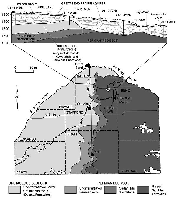
The Rattlesnake Creek corridor (Figure 6) is a pathway for natural discharge of both fresh and saline groundwater. West of US Highway 281, Cretaceous confining layers of low permeability block saltwater intrusion into the alluvial freshwater aquifer. East of that highway the direct hydraulic connection between the Permian and alluvial aquifers permits the natural brine of the Permian bedrock to move upward and contaminate the freshwater of the overlying aquifer. The nature and extent of the connection is illustrated by the map and vertical section in Figure 6.
Figure 6. Subsurface geology of the Great Bend Prairie in south-central Kansas.
Since the 1980's, Kansas Geological Survey research projects, in cooperation with GMD5, have installed and monitored a number of multi-level well sites in the region (Buddemeier et al., 1993; Young et al., 1996). The deepest monitoring wells penetrate into the Permian zone and have provided data about the variation of the level of the transition zone between fresh and saltwater.
As part of the 1992-1996 KGS Mineral Intrusion project in GMD5, an intensive study site was established adjacent to Rattlesnake Creek in cooperation with landowners Norman and Theodore Witt (Young et al., 1995a; see Young et al., 1996 for a compilation of data collected for the entire Mineral Intrusion project). The Witt site consists of three shallow observation wells, one well screened in the Permian bedrock, and a stream gage. The shallow wells were used to monitor water-level changes and water chemistry in the upper unconsolidated sediments at increasing distances from Rattlesnake Creek. The Permian well was used primarily to monitor the elevation of the freshwater-saltwater interface in the Great Bend Prairie aquifer using focused EM induction logging.
Rattlesnake Creek is a gaining stream, receiving natural groundwater discharge over most of its length. At the Witt site, water levels in all wells rose almost simultaneously, indicating good connection between the Permian zone and the shallow aquifer. Chloride concentrations in the ground waters ranged from about 200 mg/L in one of the shallow wells to about 40,000 mg/L in the Permian well. A shallow well close to Rattlesnake Creek (well WTa) had chloride content of 800 mg/L at a depth of 37 ft. The chemical data confirm that the good connection between Rattlesnake Creek and the Permian zone allows saltwater flushing into the creek. Quinodoz and Buddemeier (1997) have applied budget models to show that the saline water flow from the Rattlesnake into the Quivira National Wildlife Refuge and then to the Arkansas River is crucial to the preservation of the quality of the groundwater resources of south-central Kansas.
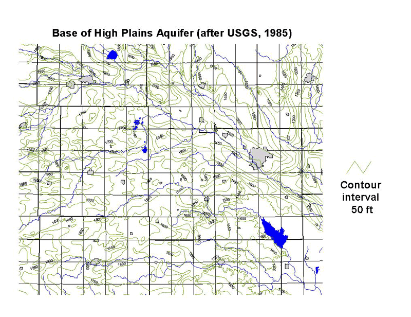
Penetration of salt water into the aquifer is not uniformly distributed, but seems to be associated with bedrock lows, including paleochannels. Maps of the bedrock elevation indicate that stream courses in past geological eras were different from the present. One such channel, as illustrated in Figure 7, is closely aligned with the present course of the Rattlesnake Creek west of the wildlife refuge, as well as with the eastward direction of groundwater flow.
Figure 7. Base of High Plains aquifer (after USGS, 1985), showing inferred paleochannel closely aligned with the present course of the Rattlesnake Creek west of the wildlife refuge, as well as with the eastward direction of groundwater flow.
Paleochannels may be avenues for the conveyance of saltwater over large distances in the freshwater aquifer. Quantitative calculations of Rubin and Buddemeier (1997) showed that the paleochannel is likely to convey saltwater to comparatively large distances only if its course is almost parallel to the aquifer streamlines. The paleochannel with a course almost identical to that of the Rattlesnake Creek meets this condition. Therefore, the Rattlesnake Creek corridor system effectively drains comparatively large quantities of salt from the region through coupled surface and groundwater flow. The salt that is not discharged through surface flow in Rattlesnake creek remains in the groundwater, and is a major source of salinity in the downgradient region of GMD2 on the south side of the Arkansas River in the Hutchinson-Nickerson area.
Rattlesnake Creek flows through the Quivira National Wildlife Refuge before it ultimately discharges into the Arkansas River. The refuge includes more than 30 marshes and ponds covering about 22,000 acres in Stafford, Reno, and Rice Counties. In the 1930s a channel was constructed to permit the creek to flow directly into the Little Salt Marsh, one of two large saline marshes in the refuge. Additional canals and ponds have since been constructed, providing the refuge with a system for managing its water supply. However, the wildlife refuge experiences serious water shortages in dry years, especially during late summer when the water demands far outweigh the water supply.
Under present conditions, the need for increased quantities of water in the Quivira National Wildlife Refuge requires that the supply be expanded without further degradation of the water quality. Since no additional water of suitable quality is available for appropriation in the region, meeting the needs of the refuge will require modification of the existing water use and/or management. The premise of this report, discussed below, is that achieving this goal can and should be coherent with an overall goal of improving the quality of groundwater resources in south-central Kansas.
2.3 Northern Stafford county
Along with the Rattlesnake Creek area, northern Stafford County was a focus of intensive study during the KGS Mineral Intrusion investigation carried out between 1992 and 1996 (Young et al., 1996). This region extends from the initial subcrop of the Permian formation in the vicinity of Highway 281 to the discharge region associated with the Quivira National Wildlife Refuge (see Figure 6). It is approximately bounded by Rattlesnake Creek on the south and the Barton County line on the north. In the western part of the region there is very high salinity deep in the alluvial aquifer; in many areas freshwater can be pumped from above a clay semi-confining layer. Farther east, fresh water resources diminish both in quantity and in quality. Saltwater upconing due to pumping is a localized problem in the west, and increasingly common to the east.
An extensive field study in northern Stafford county has been made by KGS with the cooperation of Mr. Dennis Siefkes, landowner (Young, 1995, Young et al. 1995a, 1996). The study site is centered on an irrigation well that becomes progressively saltier during the pumping season. A number of existing stock, domestic, and oil field supply wells within approximately one-half mile of the irrigation well provided a network of shallow and intermediate-depth monitoring points. In addition, KGS installed monitoring wells that were completed in the Permian bedrock and at the base of the alluvial aquifer in the vicinity of the irrigation well.
Generally, the following groundwater aquifer system components can be identified in the vicinity of the study site:
The Siefkes site study has provided a substantial amount of information about the characteristics of the aquifer system in that region. The connection between the deep aquifer and the Permian zone appears good, so every decrease of the piezometric head in the deep aquifer leads to intrusion of salt water from the Permian zone. Mitigation or prevention of saltwater penetration from the deep aquifer into the shallow freshwater aquifer is a major concern.
While there is good connection between the deep aquifer and the Permian zone, the hydraulic conductivity of the Permian zone is comparatively low. Slug test measurements of Cobb et al. (1982) show values of 0.006-9.4 ft/day (0.0018-2.9 m/day). Slug tests of Butler et al. (1993) gave values of 0.0037-0.14 ft/day (0.001-0.04 m/day); and slug tests of Gillespie and Hargardine (1993) showed values of 0.2-0.7 ft/day (0.06-0.2 m/day). Pumping tests in the Great Bend Prairie aquifer gave hydraulic conductivity values of 56-230 ft/day (17-70 m/day) (Layton and Berry, 1973; Fader and Stullken, 1978; Cobb, 1980; 1983; Sophocleous et al., 1987). Slug tests of the Great Bend Prairie aquifer (Butler et al., 1993) gave somewhat lower values of 10.8-88 ft/day (3.3-26.8 m/day). The low hydraulic conductivity of the Permian zone may provide some protection of the Great Bend Prairie aquifer against saltwater intrusion from the Permian zone.
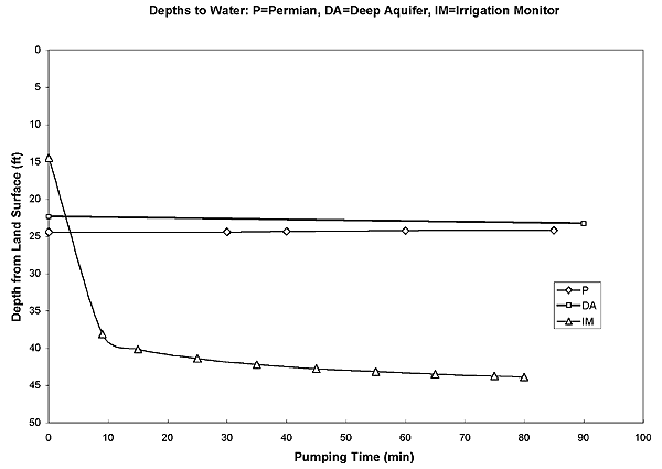
In the past it was commonly assumed that in northern Stafford County, clay lenses effectively separate the freshwater shallow aquifer from the deep aquifer. However, measurements of groundwater elevation and water chemistry at the Siefkes site (Young, 1995) showed that this separation might suffer from local discontinuities. The irrigation well at the Siefkes site is drilled to a depth of 120 ft below the ground surface. At a depth of about 130 ft below the land surface there is a clay layer about 10 ft thick. Under conditions of no pumping the water level in the freshwater aquifer was higher than the water levels in monitoring wells that penetrate into the deep aquifer, and chloride content was low. However, that situation was quickly and significantly changed when the irrigation well operated, as exemplified by Figures 8 and 9. Within a few hours the groundwater level was subject to a significant drawdown (30 ft), the vertical head gradient reversed, and the chloride content increased from about 135 mg/L to 330 mg/L. Chloride concentration increases were even greater after sustained pumping, and late in the irrigation season. These observations indicate that even in places where a clay lens occurs, separation between the freshwater aquifer and the deep aquifer is not complete, and measures need to be taken to avoid dangerous increases of salinity in the fresh groundwater resource.
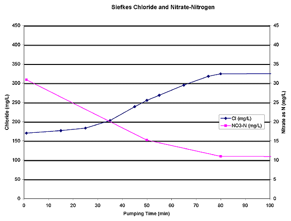
Groundwater quality in northern Stafford County is affected not only by naturally occurring chlorides, but also by nitrate concentrations affected by agricultural practices. Measurements reported by Young (1995) indicate elevated concentrations of nitrate in the shallow groundwater. Measured concentrations of more than 10 mg/L as nitrate-N (equivalent to 45 mg/L as nitrate) exceed the drinking water limit for public supplies. These high concentrations of nitrate originate from use of fertilizers in the region, human and animal wastes, etc. Since these sources are at the land surface, nitrate behaves in a complementary fashion to chloride during the pumping cycle. Figure 9 shows that as pumping continues, the relative proportion of deeper water increases, leading to an increase in the chloride (source at depth) and a decrease in the nitrate (with a surface source).
Figure 8. Water levels at the onset of a pumping cycle at the Siefkes intensive study site in northern Stafford County. P (diamond symbols) indicates the Permian monitoring well, DA (squares) is the deep aquifer head, and IM (triangles) show the water level observed in the overlying freshwater aquifer.
Due to the comparatively small thickness and depth to water of the freshwater aquifer, it is expected that nitrate concentrations will continue to increase. Even after pumping had more or less stabilized the nitrate levels observed in the Siefkes irrigation water, the concentrations were still above the standards for potable water. Groundwater in this region can be used for irrigation unless the chloride levels rise too high, but is already unsuitable for human consumption without treatment to reduce the nitrate levels.
Figure 9. Chloride and nitrate-N concentrations in groundwater pumped during the early stages of an irrigation pumping cycle at the Siefkes intensive study site in northern Stafford County.
2.4 The Ninnescah Basin
Only studies of limited scope have addressed mineral intrusion scenarios in the Ninnescah Basin (southern GMD5). As indicated by Figure 3, there are several clusters of locations where saltwater penetrates into the aquifer adjacent to and between the South and North Forks of the Ninnescah River. Gillespie and Hargadine (1993) report on saltwater penetration in this area, and suggest that it may be associated with fractures. Although clay lenses provide adequate separation between the Permian saltwater and the freshwater aquifer in much of the area, saltwater springs and the high chloride concentrations in some clusters of wells indicate that groundwater quality in this region is not safe. Precautions should be taken to avoid deterioration of the groundwater quality due to enhanced penetration and lateral transport of saline water.
2.5 Summary of risks and issues
Saltwater that saturates the Permian bedrock may penetrate into the fresh groundwater system of south-central Kansas. However, the risk of saltwater intrusion varies from area to area. Studies of the area permit classification of the different regions according to their particular risks.
The quality of groundwater resources in the region of Hutchinson-Nickerson under current conditions is mainly threatened by the migration of groundwater of low quality from south to north of the Arkansas River. A substantial amount of the salinity south of the river originates upgradient in the Rattlesnake Creek and northern Stafford county areas, and moves slowly eastward with the groundwater flow. However, penetration of saltwater from the Permian zone into the freshwater aquifer may also occur locally south of the river, due to the good connection between the freshwater aquifer and the Permian zone in parts of that region. Some risk of oil brine and salt-mine mineralization also occurs in this region but these problems are localized and generally well understood. In the Rattlesnake Creek corridor the connection between the Permian zone and the Great Bend Prairie aquifer is good, and under normal water table conditions groundwater discharge to the stream is substantial. This region represents the major avenue for discharge of saltwater from the Permian zone into surface flow. Water flowing in Rattlesnake Creek supports the survival of the wildlife refuge in the Quivira marsh area, and also is the major avenue for salt removal from the larger area as it discharges into the Arkansas River.
In northern Stafford County a very delicate balance of piezometric heads preserves the shallow freshwater aquifer and controls saltwater intrusion from the deep aquifer. In areas where there is inadequate geohydrologic confinement of the deep saline water, high-volume pumping causes upconing of salt water and contamination of the freshwater zone of the aquifer. Potential uses of the groundwater are further limited by high and increasing nitrate concentrations in the shallow water.
In the Ninnescah Basin the quality of groundwater resources is generally preserved due to comparatively good separation between the saltwater and the freshwater aquifer. This separation consists of deposits of clays and shale. However, clusters of high salinity wells, as well as existing saline springs, indicate that the quality of groundwater resources is not completely safe in this region, and preservation measures are needed to prevent more widespread salinization, especially in areas of heavy groundwater extraction.
Surface water infiltrates to deep groundwater in southeastern Colorado, arrives at impermeable formations, and then moves downgradient eastwards through confined layers while dissolving minerals (Macfarlane 1993, 1995, 1997). The confining layers, originating from marine deposits, extend horizontally to central Kansas (up to US Highway 281), where the Cedar Hills Sandstone subcrops. East of that highway the freshwater aquifer, originating from terrestrial deposits, is basically in contact with the bedrock formation of Permian age. The Permian bedrock is saturated with saltwater. Direct contact between the fresh and saline water is often prevented by the presence of lenses of clay and shale deposits. Generally, a state of equilibrium is created between the forces leading to salinity penetration into the freshwater aquifer and the conditions that prevent this phenomenon. Parameters controlling the salinity penetration are:
Quantitative evaluation of the balance among all these parameters, which determines the quality of groundwater in the region, is extremely important. However, the heterogeneity of the porous media complicates quantitative calculation. Therefore, a variety of field and theoretical studies were performed by the Kansas Geological Survey to identify various possible states of equilibrium among the parameters described in the preceding paragraphs. Then several approaches were taken to identify conditions that would enable safe use of groundwater resources in south-central Kansas. Three different approaches were found to be appropriate, and their use in parallel has provided some important information:
The following sections specify the principles and outcomes of these approaches.
3.1 Salt budgets
The general idea of salt budget calculations is that for a well defined region it is possible to calculate the balance between variations of average groundwater salinity in the region, and salinity inflow and outflow. Steady state is obtained when the total salinity outflow is identical to the salinity inflow. Under such conditions the quality of the groundwater resource neither deteriorates nor improves. Budget calculations can also address the effect of intensive irrigation on the groundwater chemistry. Studies in semi-arid regions have shown that irrigation effects on the water chemistry may be very significant even on a comparatively short time scale. In south-central Kansas, chloride balance may be affected by irrigation through various mechanisms, and these effects should be considered to assure preservation of the groundwater resource quality.
Quinodoz and Buddemeier (1997) developed a budget model based on measured and calculated water flows and salt concentrations. It was constructed for the calculation of quantities of salinity transported down gradient from GMD5. The study divides GMD5 to three areas: 1) Northern study area (Rattlesnake basin, Stafford County), 2) Central study area (N. Fork Ninnescah River basin, Stafford/Pratt counties), and 3) Southern study area (S. Fork Ninnescah River basin, Pratt County). The simulations provide figures for salt fluxes out of GMD5 by both surface water and groundwater. It was found that major quantities of salt are transported out of the northern study area by the following flows: 1) About 86 MkgCl/yr (190 MlbCl/yr) are discharged as surface water into the Arkansas River, and 2) About 40 MkgCl/yr (88 MlbCl/yr) are transferred by groundwater down gradient towards GMD2.
In the central study area calculated fluxes of salinity out of GMD5 were about 41 MkgCl/yr (90 MlbCl/yr) surface water flux, and 12 MkgCl/yr (26 MlbCl/yr) groundwater flux.
In the southern study area calculated fluxes of salinity out of GMD5 were about 24 MkgCl/yr (53 MlbCl/yr) surface water flux and 8 MkgCl/yr (18 MlbCl/yr) groundwater flux.
The figures given above imply that surface water flow removes the larger portion of the salinity that penetrates from the bedrock into the freshwater aquifer of GMD5. Natural preservation of the groundwater quality depends on maintaining streamflow adequate to take away most of the salinity. However, pumping can have a significant effect on the delicate balance between the salt fluxes into the rivers and quantities of salt that penetrate and disperse in the groundwater, since lowering the water table may both enhance local saltwater penetration from the bedrock, and at the same time reduce natural discharge to streamflow.
Young et al. (1998) made budget chloride calculations for the EBMI area of GMD2. They used the figures of Quinodoz and Buddemeier (1997) to estimate the contribution of the northern study area of GMD5, as salinity fluxes of groundwater are directly transported from there to GMD2. These results showed an estimated inventory of 6,000-7,000 MKgCl (13,200-15,400 MlbCl) in the EBMI region, of which 2,000-3,000 MkgCl (4,400-6,600 MlbCl) could be accounted for by a steady-state influx from northern GMD5. Although the estimated values are too uncertain to be confident that the discrepancy is significant, it is consistent with the existence of local bedrock discharge of salt into the GMD2 aquifer, which is also suggested by the association of high salinities with bedrock lows. The budget values are too crude to resolve the question of salt penetration from south to north beneath the Arkansas River, but they definitely suggest that there is a threat from multiple sources if adequate flow barriers along the river are not preserved.
3.2 Salinity penetration mechanisms
Studies by Rubin and Buddemeier (1996, 1997, 1998a, b, c, d, e) identify two major mechanisms of salinity penetration from the bedrock into the freshwater aquifer: 1) Direct contact between fresh and saltwater, and 2) Seepage of saline water into the freshwater aquifer through a semiconfining layer. The existence of such mechanisms in the study area are implied by the study of Young and Rubin (1998), which showed that in some locations of the Great Bend Prairie aquifer, salinity penetrates into the freshwater aquifer where piezometric heads at the Permian zone and the fresh aquifer are identical. Such a phenomenon can be depicted as interfacial salinity penetration (Rubin and Buddemeier, 1998a). In other locations, there are differences in piezometric head between the Permian zone and the freshwater aquifer. Such conditions imply mineralization due to seepage of saltwater through a semi-confining layer (Rubin and Buddemeier, 1998b). The two general mechanisms may be affected by local features of the formations, as discussed in the following paragraphs.
3.2.1 The Hutchinson-Nickerson region
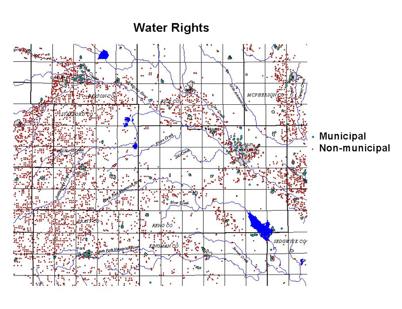
In the Hutchinson-Nickerson region different sources of salinity exist south and north of the Arkansas River, as inferred from the results of field monitoring. The distribution of water rights in the region is discussed in section 3.2.3 below, with Figure 13 illustrating the location of the municipal and other rights north of the river and the general lack of water use south of the river that reflects the occurrence of unacceptably high salinity in the groundwater of that area.
A major source of concern about the salt budget is the horizontal penetration of salinity from south to north under the Arkansas River. This is promoted by reduced elevations of the groundwater table north of the river. Low levels of the groundwater table might also lead to saltwater penetration from the bedrock into the aquifer, but there is no present evidence of local intrusion there, and not sufficient information about salinity distribution in the bedrock north of the Arkansas River to make definite predictions. There are also localized effects of releases of salt mine waste and oil brines in this region.
At monitoring sites (see Figure 5) with more than one well, water-level changes were generally synchronous in the different wells, particularly north of the Arkansas River. In fact, north of the river, where clay lenses are less common, virtually no vertical hydraulic gradient was observed at most of the sites, indicating very good hydraulic connection. Exceptions are sites EB266 and EB261, which are located just north of the river, where upward vertical hydraulic gradients were observed.
In locations of good hydraulic connection between the freshwater aquifer and the Permian bedrock, upconing and interfacial diffusion are the major potential mechanisms of salinity transfer from the bedrock into the freshwater aquifer. This transfer occurs only if water of high salinity is present in the bedrock, and the intensity of the transfer is strongly affected by the difference between the hydraulic conductivity of the aquifer (estimates of which range between 56 and 230 ft/day [17 and 70 m/day]) and the bedrock (estimates of which are typically orders of magnitude lower). If the hydraulic conductivity were the same in both layers, 1 ft of drawdown in the groundwater surface could lead to upconing of about 40 ft of the interface between fresh and saltwater if the bedrock brine density is 2.5% higher than that of freshwater. On the other hand, in cases of very low permeability of the bedrock and a comparatively short time of water table drawdown, the only effect might be a limited saline transition zone at the bottom of the aquifer. If the groundwater table were then raised, the interface between saline and freshwater could penetrate into the bedrock, and the transition zone would be subject to shrinkage due to the lower dispersivity typical of the low permeability bedrock. However, if the groundwater table is lowered for a comparatively long period (e.g., due to sustained or excessive pumping) then significant quantities of saltwater may penetrate from the bedrock into the aquifer, reducing the quality of the groundwater resources.
Water level data collected for the EBMI study and the associated well hydrographs are compiled in KGS OFR 2000-30. At site EB257 south of the Arkansas Rive (see Figure 5), where clay layers or lenses are more widespread, the water level in the C well rose above those in the A and B wells in October 1997, and has remained above (except for a short period in 1998), resulting in conditions favorable for upward flow. Upward vertical hydraulic gradients also occur south of the river at sites EB256, EB267 and EB270. These observations could be signs of semiconfined conditions, with significant implications for the lateral transport of salt and water. Higher water levels were observed in the deeper (B and/or C) wells compared with the shallow wells at sites EB256, EB261, EB266, EB267, and EB270. Again, this phenomenon probably indicates semiconfined conditions at depth, and the potential for upward flow exists at these sites. This could also be a reflection of the high Permian head at these sites. Boreholes were generally drilled a few feet into bedrock for freeboard to ensure that screens could be placed as close to the bedrock contact as possible. Most of these sites are located near major surface water features. Sites EB261 and EB266 are located near (just to the north of) the Arkansas River; EB256 is located near Salt Creek.
The accumulated chemical data (compiled in KGS OFR 2000-30) show temporal changes in some of the wells. Changes of chloride concentration between the four sampling times were perhaps most noteworthy in well EB255C. This well is located north of the Arkansas River. In that well, the chloride concentration increased from 489 mg/L in Spring 1997 to 744 mg/L in Spring 1998 (an increase of 255 mg/L). Figures 10 and 11 are cross sections illustrating changes in chloride concentrations from Spring 1997 to Spring 1998. These changes indicate possible penetration of salinity from the south of Arkansas River to the north of the river. Water pumping in proximity of the river may lead to significant local changes in flow directions and salinity transport. The water level data indicate that under current conditions, the Arkansas River does not comprise a consistently effective barrier against the penetration of groundwater of high salinity from south to north of the river. This phenomenon, if it continues, is a threat to the wells that supply drinking water to Hutchinson and Nickerson.
Chloride concentrations at the other monitoring sites bordering the river on the north remained fairly consistent for the four sampling times in 1997 and 1998, with one exception: well EB261A averaged about 220 mg/L; EB261C dropped from 892mg/L to 786 mg/L, EB266A averaged about 735 mg/L, and EB266B remained about 1,200 mg/L. Changes of chloride content originate from changes in the equilibrium between aquifer fluxes induced by the presence of the Arkansas River, artificial pumping, and natural recharge.
Figure 10. Hydrogeologic cross section through Willowbrook-Partridge section showing changes in inferred distribution of chloride--Spring 1997 to Spring 1998.
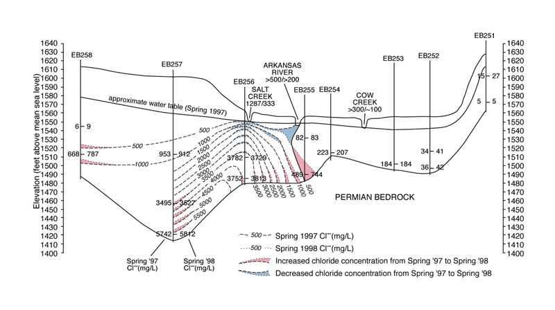
Figure 11. Hydrogeologic cross section through Nickerson section showing changes in inferred distribution of chloride--Spring 1997 to Spring 1998.
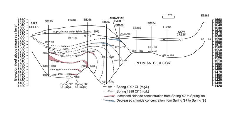
Chloride concentrations increased in many deep wells south of the Arkansas River, particularly in EB256C, EB257C, EB268B&C, EB269C, (and EB248C, which is located south of Hutchinson, east of the main study area). From Spring 1997 to Spring 1998, chloride concentration showed a net increase in the deepest well at all sites south of the Arkansas River except at site EB267. However, concentrations in most of those wells decreased in the Fall 1998 sample. Well EB270A showed an increase in chloride concentration from 2,765 mg/L in Spring 1997 to 2,940 mg/L in Spring 1998, then to 3062 in Fall 1998, possibly a local phenomenon, due to local release of chloride. The steep bedrock slope near site EB270 (Figure 11) could be conducive to bedrock discharge, especially if relatively permeable horizons are exposed.
Studies by Rubin and Buddemeier (1998a, b, c, d, e, f) show that with constant seepage of saltwater and the water budget at equilibrium, the salinity should stabilize at a constant steady state value at the bottom of the aquifer. However, the data indicate that the salinity is still subject to increase at the aquifer bottom south of the Arkansas River. This implies that under current conditions, either seepage of saline water from the Permian bedrock is still increasing or the flux of freshwater is decreasing. This could reflect changes at or near the observation points, or upgradient near the sources of saltwater in northern GMD5. Whatever the source, deterioration of the quality of the groundwater resources appears to be ongoing.
A significant decrease in chloride concentration from 2046 mg/L in Spring 1997 to 1688 mg/L in Spring 1998 occurred in EB256A, adjacent to the Salt Creek collection point. The concentration in Salt Creek decreased from 1287 to 333 mg/L. These declines resulted from dilution by the heavy precipitation, and illustrate the short-term variability that complicates long-term prediction of water-quality effects.
3.2.2 The Rattlesnake Creek corridor
In the Rattlesnake Creek corridor there is good connection between the Permian zone and the Great Bend Prairie aquifer. Saltwater discharges to the stream, and penetrates the land surface as local springs and seeps. The presence of a paleochannel close to and below the eastward-flowing reach of Rattlesnake Creek probably allows comparatively easy penetration of saltwater to the land surface. Only in very limited areas is the salinity of groundwater low enough for human uses.
The Rattlesnake Creek corridor is characterized by a combination of several features that lead to comparatively high saltwater discharges penetrating the land surface: a) there is limited cover of subsurface clay lenses, so Permian zone saltwater is not prevented from penetrating into the entire vertical extent of the Great Bend Prairie aquifer, b) a paleochannel, located at a course closely matched with that of the Rattlesnake Creek, represents a specific avenue for Permian water transfer into the aquifer (Figure 7), and c) groundwater horizontal gradients are almost parallel to the course of the Rattlesnake Creek and the paleochannel, so the paleochannel system is able to convey groundwater of comparatively high salinity to large distances down gradient (Rubin and Buddemeier, 1997).
3.2.3 Northern Stafford County
In northern Stafford County, clay lenses commonly exist at various depths within the permeable formations; in particular, extensive clay layers on the order of 10 ft thick occur over much of the area at depths ranging between roughly 110-160 ft below land surface, and a few tens of feet above the bedrock. These layers may effectively separate the saltwater of the Permian bedrock from the freshwater aquifer above the clay. The deeper part of the alluvial aquifer below the clay contains substantial amounts of saline water from the Permian zone. Because the hydraulic conductivities of the upper and lower aquifers are similar, the only protection against pumping induced salinization is the integrity of the clay lenses (see discussion of the transfer mechanisms in section 3.2.1 above).
The field studies at the Siefkes site indicate that the protection of the groundwater quality by clay lenses may be very limited in some locations. Discontinuities in the clay layer allow saltwater seepage into the freshwater aquifer if the level of the groundwater table is reduced below the piezometric head of the saltwater in the deep aquifer, beneath the clay lenses. Such seepage was induced by the irrigation well at Siefkes site. The possible effect of the saltwater seepage through discontinuities in the impermeable clay layers has been quantitatively described by several studies of Rubin and Buddemeier (1998 a, b, c, d). Unfortunately, the field data available are not sufficient to consider all the implications of those studies. However, the combined field and theoretical studies show that due to the temporary local drawdown of the aquifer water table during the operation of the irrigation well at the Siefkes site the saltwater penetrates into the shallow aquifer and creates a saltwater mound in the aquifer, as shown in Figure 12. When the irrigation well stops operating, the groundwater table recovers, and groundwater flow returns to its initial eastward direction. Then the saltwater mound moves down gradient while its shape is flattened, due to density currents, and its salinity is gradually transferred into the surrounding groundwater. This oscillating seepage of saltwater into the aquifer reduces the quality of groundwater down gradient of such pumping wells, and ultimately in the region. Figure 13 shows the distribution of water rights, most of which are high-capacity wells, in the region. It also illustrates clearly the decreasing use and availability of water from west to east in northern Stafford County and in the down-gradient areas to the east.
Figure 12. Schematic of saltwater mound created during groundwater pumping. As the shallow aquifer head is drawn below the head of the deep aquifer and Permian bedrock in the vicinity of the pumping well, saltwater is drawn up through discontinuities in the semipermeable layer. When pumping stops, the saltwater mound moves downgradient on top of the semipermeable layer, remaining in (and contaminating) the freshwater zone of the aquifer.
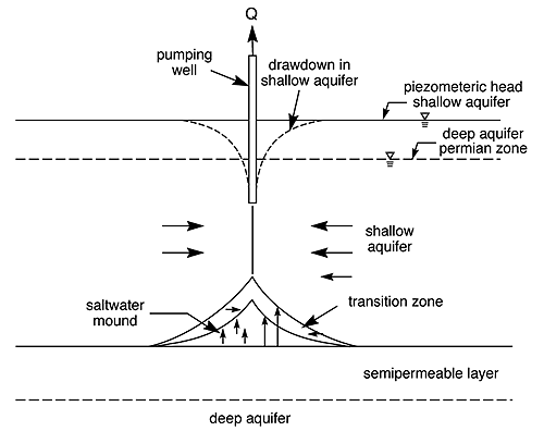
Figure 13. Distribution of water rights in the overall region. In northeastern Stafford, southwestern Rice, and northwestern Reno counties, groundwater is available but is too saline for most uses, so there are few water rights in the area.
3.2.4 The Ninnescah Basin
The KGS study involved only a limited number of measurements of groundwater levels and salinity distribution in the Ninnescah Basin. At some specific locations measured salinity is comparatively high, as indicated by the salinity map (Figure 3). However, in most places, it seems that relatively good separation between the Permian zone and the Great Bend Prairie aquifer is provided by clay and shale lenses, as is indicated by the distribution of water rights in the region (Figure 13). The study of Rubin and Buddemeier (1997) addressed possible effects of paleochannels in this basin as an instrument for penetration and conveyance of saltwater. The paleochannels in this region may be a preferred location for saltwater penetration into the aquifer, which may lead to local saltwater springs. However, as the course of the paleochannels in this region is quite different from the streamlines of groundwater flow, the paleochannels cannot convey significant quantities of saltwater to large distances. Saltwater that penetrates into the groundwater flow leads to an increase of salinity in a limited area that is drained to either the North Fork or South Fork of the Ninnescah River.
3.2.5 Summary of implications
In the Hutchinson-Nickerson region, local saltwater penetration from the Permian zone has not yet been observed north of the Arkansas River. However, there is no separation between the Permian zone and the freshwater aquifer, so the lack of mineral intrusion is probably due to low salinity and/or comparatively low permeability in the Permian zone, combined with relatively high levels of the groundwater table. Risks to groundwater quality in this region are mainly due to horizontal penetration of groundwater of low quality from south to north of the Arkansas River. However, the potential for local intrusion is not known, since there has been no assessment of the Permian bedrock salinity in the area.
Saltwater penetration is affected by differences between the piezometric head of the Permian saltwater (that is already at or above the deep aquifer head in some locations) and the piezometric head of the freshwater aquifer. The presence of clay lenses between the freshwater aquifer and the Permian zone (or the deep saline aquifer) may provide a separation between the two types of water. However, discontinuities in these separating layers can convey large quantities of saltwater into the freshwater aquifer, especially when pumping wells lead to significant local drawdowns of the groundwater table. Such phenomena are typical of northern Stafford County.
In the Rattlesnake Creek corridor, there is good connection between the Permian zone and the Great Bend Prairie aquifer. The presence of a paleochannel whose course is almost parallel to Rattlesnake course and the groundwater streamlines makes this region a major location of saltwater penetration to the land surface and downgradient transport.
In the Ninnescah Basin penetration of saltwater is limited, due to comparatively good separation between the Permian zone and the freshwater aquifer. However, high salinity of groundwater occurs in several sensitive locations. Paleochannels in this region can be preferred locations for penetration of saltwater, resulting in saline springs or dispersal into the freshwater aquifer.
3.3 Salinity advection and dispersion
Following its penetration into the aquifer the salinity, or saltwater, is either withdrawn by the water users or advected to other locations. Consumption of water with somewhat elevated salinity is possible, at least temporarily, but increasing salinity will eventually lead to curtailment of use. Temporary pumping of saltwater creates a saltwater mound that moves down gradient with the groundwater flow. During its advection the saltwater mound is reduced by loss of salinity into the surrounding groundwater. Studies of Rubin and Buddemeier (1996, 1998a, b, c, d) provide quantitative descriptions of the combined salinity advection and dispersion of saltwater which penetrates into the aquifer through discontinuities in the impermeable clay layers either by interfacial salinity transfer or by saltwater seepage. At large distances from the discontinuity in the impermeable layer the salinity profile becomes practically uniform, and salt concentration may be significant through the entire thickness of the aquifer.
High salt concentrations may persist and be transported over large distances where saltwater penetrates into paleochannels that are parallel to the groundwater streamlines. Such conditions probably take place in the Rattlesnake corridor. If the course of the paleochannel is not parallel to the streamlines of the groundwater, then saltwater penetrating into the paleochannel disperses into the overlying groundwater, and dilution reduces the negative effect of the high salt concentrations. This phenomenon is believed to occur in the Ninnescah Basin and elsewhere.
Advected salinity comprises the major risk to groundwater resources quality in GMD2, where groundwater with comparatively high salinity flows from south to north of the Arkansas River. Some of the salinity south of the river is advected from the Rattlesnake Creek corridor and northern Stafford County areas upgradient, but there is probably local penetration from the bedrock as well.
Natural and artificial effects both contribute to the threats to the quality of groundwater resources in south-central Kansas. Natural processes have brought saltwater into the Permian zone, and continue to contribute to mineral intrusion into some of the deeper aquifer regions and bedrock channels. Natural saltwater discharge releases water of high salinity at various places in south-central Kansas. The Rattlesnake Creek corridor is the major location for the natural release of saltwater to the land surface. Surface flow of this water of comparatively high salinity into the Quivira marsh has been engineered to meet the basic water needs of the wildlife refuge. However, the reduction of streamflow due to groundwater pumping puts the refuge water supply at risk, and also reduces the drainage of salt into the Arkansas River, which can lead to further salinization of the groundwater down gradient.
Artificial decrease of the groundwater table elevation in the Hutchinson-Nickerson region has created the current threat to groundwater quality by the migration of low quality groundwater from south to north of the Arkansas River. There is also an unknown potential for the low levels of the groundwater table north of the river to lead to local saltwater intrusion from the Permian bedrock.
Water use in some regions leads to significant drawdown of the groundwater table. In some places, like northern Stafford County, this phenomenon may have increased the penetration of saltwater from the Permian zone into the deep aquifer, which is presently saline. The deep aquifer is separated from the shallow freshwater aquifer in many areas by relatively thin clay layers. Threats to the groundwater quality in northern Stafford County therefore are in part a result of the artificial drawdown of the groundwater table by high rates of pumping for irrigation purposes. Continuation of the current high rates of pumping, with no preventive measures will lead to gradual mineralization of the shallow freshwater aquifer in that region. In addition, fertilization and farming in that region increase the nitrate concentrations, which already exceed drinking water standards locally.
Remedial measures and appropriate management, including artificial technological means of manipulating water supply and quality, can be implemented to preserve the groundwater quality of south-central Kansas. Possible approaches are given below.
5.1 Monitoring
Studies of mineral intrusion into GMD5 and GMD2 have indicated that salinity penetration into the groundwater is greatly affected by both natural and man-made conditions. Preservation of the groundwater resources requires adequate monitoring of the critical parameters that are subject to seasonal and annual changes; some parameters are subject to change on a shorter time scales. Such parameters are:
The items in the above list are not all independent. Groundwater levels are the product of recharge and pumping, and stream flow is a function of precipitation and groundwater level. This means that there will usually be multiple ways of achieving the same overall monitoring objective--for example, by monitoring water levels at key locations and using pumping rates or volumes as a proxy to estimate level changes in other areas. Details of specific requirements for the monitoring systems at each area are provided in following paragraphs.
5.1.1 The Hutchinson-Nickerson region
The primary objective of monitoring the state of the aquifer in the Hutchinson-Nickerson region is to evaluate the occurrence of or potential for penetration of saline water from south to north of the Arkansas River. If the Arkansas River's function as an avenue for salinity drainage from both south and north of the river is preserved, and especially if head gradients in the deeper portions of the aquifer do not drive northward flow, the potential for salinity penetration and buildup north of the river will be reduced. Secondary objectives include detection of salinity buildup at depth in the aquifer, particularly near or upgradient from the municipal supply wells, and continued assessment of Cow Creek as a discharge avenue for local salt sources.
The monitoring program established for the EBMI study forms a satisfactory basis for developing a long-term system. However, a number of refinements or modifications should be considered.
5.1.2 The Rattlesnake Creek corridor
The primary objectives of a monitoring program for the Rattlesnake Creek corridor should be evaluation of streamflow for the transport of both water and salt, and the effects of water table variations on streamflow and quality. Secondary objectives should be evaluation of changes in the deep aquifer salinity (salt penetration rates or patterns) and the quality of the groundwater flow into GMD2 at the east end of the corridor and east of the Quivira National Wildlife Refuge.
The proposed primary objectives are probably adequately served by existing measurement programs of GMD5, QNWR, the USGS (stream flow and water quality measurements), the Division of Water Resources of the Kansas Department of Agriculture, and the KGS. However, a cooperative program for assembly and integrated interpretation of the components should be developed.
Secondary objectives are more challenging, and may not be fully met at present. One of the specific data lacks is knowledge about the role of bedrock paleochannels in preferential transport of saline water. This is an area in which further assessment and interagency cooperation is probably needed. However, since the issues addressed are long-term fluxes, a suitable program can be developed gradually.
5.1.3 Northern Stafford County
As indicated by preceding sections, the quality of groundwater resources in northern Stafford County depends on a very delicate balance between the piezometric head of the aquifer freshwater and the piezometric head of the deep aquifer saltwater that is located underneath the local impermeable and semi-permeable layers created by clay lenses. This separation is not complete, so monitoring the vertical distributions of both heads and chloride contents is extremely important in this region. Due to the delicate balance between the piezometric heads of salt and freshwater in this region and the rapid, strong effects of pumping in areas of incomplete separation, it is highly desirable to measure groundwater levels and chloride content frequently (e.g., weekly) during the irrigation season. For practical purposes, such intensive observations should be focused on key indicator areas or locations of known contamination or vulnerability.
The monitoring and assessment efforts of GMD5, combined with the earlier KGS-GMD5 Mineral Intrusion study, probably form a useful basis for design of a monitoring system for salinity effects. Water quality in the area is also threatened by increasing nitrate concentrations, which are likely to continue to increase and further limit the use of groundwater for drinking purposes. The salinity monitoring program suggested can also address nitrate concentrations, although both require additional data assessment and design for effective implementation.
5.1.4 The Ninnescah Basin
Generally, comparatively good quality of groundwater resources characterizes the Ninnescah Basin. However, clusters of some wells with high salinity, as well as presence of some saline springs, indicate that sensitive locations should be identified and monitored for water levels and salinity, at least during the irrigation season. Here also, ongoing GMD5 programs, combined with the results of past studies, can probably serve to establish an adequate network and program, but systematic design is recommended.
5.1.5 Summary of monitoring objectives and performance
Monitoring levels of the groundwater table and salt content in groundwater in sensitive spots is extremely important. Adequate monitoring is the only source of information about the state of groundwater resources and about trends in condition. It can also provide guidelines for appropriate measures leading to preservation of the groundwater quality and possible remedial measures.
Monitoring is basically required in the areas addressed by this report. However, assessment and design of monitoring is most crucial in Hutchinson-Nickerson region and northern Stafford County.
Monitoring in the Rattlesnake Creek corridor is very important for the evaluation of salt quantities discharged from the area into the Arkansas River through the Quivira marsh area, and through the groundwater aquifer in places located down gradient from Rattlesnake Creek. However, the current concerns about Quivira NWR water supplies has resulted in a composite program of measurements that would probably be adequate if fully integrated.
Monitoring is suggested in the Ninnescah Basin to better identify and track threats of saltwater intrusion in the vicinity of clusters of high salinity wells and saltwater springs in this area.
In all of the areas indicted, existing knowledge and programs are distributed among multiple agencies. It is strongly recommended that a coordinated network be established for assembling the relevant information for overall system review and design. This can be done electronically using internet links, so that each agency retains control of and responsibility for its own data and programs, while providing avenues for integrated use and evaluation.
5.2 Redlines--Critical Action Thresholds
The studies performed in GMD5 and GMD2 have led the authors to recommend adoption of 'redline' values for parameters connected with the groundwater quality. The term 'redline' refers to values that have been determined to indicate a level of actual or potential problems that require pre-planned action in order to protect the groundwater resources. Although the term is not widely used in Kansas, the concept is already applied: Minimum Desirable Streamflows are 'redline' values that result in curtailment of water use by junior right holders if the values are not met over a sustained period. Other examples can be found in the water quality requirements associated with water supplies and discharge permits. The redlines proposed here would refer to levels of the groundwater table and water chemistry, mainly chloride content; they may vary from place to place according to the local features. The responses to approaching the redlines could include:
Most of the above actions would require prior legislative or administrative action, or economic investment. The suggestions made are therefore presented for discussion and evaluation rather than with expectation of prompt implementation. These are, however, the kinds of measures required if water supplies are to be reliably protected over the long term. The features of possible redline recommendation in each particular area are described in the following paragraphs.
5.2.1 The Hutchinson-Nickerson region
The groundwater table south of the Arkansas River is usually higher than the river water stage. This situation should be preserved to allow drainage of salinity from the region into the Arkansas River. Since withdrawals are low in this area, this is unlikely to require intervention. However, in spite of the relatively unaltered head, measurements have indicated that the salinity at the aquifer-bedrock interface is subject to increase. No specific measures are recommended, except for the maintenance of the Arkansas River as an avenue of salt drainage from south and north of the river. However, continued monitoring is indicated, since increasing salinity at depth south of the river increases the importance of preventing south-to-north subsurface flow, and may also indicate a need for assessing upgradient conditions to determine if salt penetration or transport is increasing.
North of the Arkansas River the current groundwater heads create several risks. The most immediate concern is salinity penetration at depth to the north side of the river; a longer-term issue is regional salinization because of reduced salt discharge to the river. Two stages of redline development are therefore recommended:
Redline values of salinity need to be determined locally, and refined on the basis of experience once the program is implemented. General values can be suggested as guidelines: in extreme cases an adopted redline of salinity (chloride) should be in the range of 300 mg/L, to avoid deterioration of groundwater to a degree that it cannot be used for drinking. However, due to the vulnerability of the groundwater resources north of the Arkansas River, a redline for this stage of about 200 mg/L is recommended for water pumped from the aquifer, and about 350 mg/L in monitoring wells at the base of the aquifer. This latter value is lower than some concentrations already observed north of the river (EB255~750; EB261~900; EB266~1200 [800 shallow]). This reflects the judgment that these existing high values are matters of concern, requiring extended assessment and possibly action.
5.2.2 The Rattlesnake Creek corridor
No specific redlines should be adopted in the Rattlesnake corridor, at least until the measures under consideration to develop the QNWR water supply have been finalized and implemented. However, annual quantities of salt drained by the Rattlesnake corridor should be monitored, and overall programs should have as one of their objectives the maintenance of average salt discharge over a multi-year basis.
Redline values may be appropriate for ultimate inclusion in programs to monitor deep salt penetration, or groundwater transport out of the region.
5.2.3 Northern Stafford County
Because of the delicate balance between the piezometric head of the freshwater aquifer and the deep aquifer saltwater located beneath incomplete clay layers, redline values for the groundwater elevation and salinity are not sufficient by themselves. An overall objective should be to keep the elevation of the groundwater table significantly above the piezometric head of the saltwater on an annual average basis throughout the region. However, use of high capacity irrigation pumps causes local drawdown that induces local upcoming of saltwater that propagates downgradient and reduces overall water quality. Therefore, at sites sensitive to salinity penetration, limitations on sizes of well pumps and duration of pumping should be implemented. These restrictions may be difficult for the water consumers, but without them the groundwater resources may be completely lost. Implementation of advisory redlines for regional average groundwater levels and salinity should be implemented immediately while a program of effective responses is developed. Similarly, advisory redlines should be developed for the sensitive areas identified for monitoring, in order to assess what restrictions on pump size, duration of pumping, and pumping intervals might be used to protect the resource while continuing its use.
The increasing nitrate concentrations inhibit use of the groundwater resources for drinking purposes, unless measures are taken to reduce the increasing nitrate concentration. Under current conditions, monitoring of nitrate concentration is crucial for the public health. Normally, nitrate concentration exceeding 45 mg/L (10 mg/L as nitrate-N) is considered as threatening the public health. This is a regulatory action redline of sorts (i.e., do not feed to infants), but if protection rather than reaction is considered, redline values below the actual use threshold would be required.
5.2.4 The Ninnescah Basin
In sensitive areas of the Ninnescah Basin it may be necessary to develop quantitative descriptions of the combined salinity advection and dispersion to determine appropriate redline values for the local clusters of salinity observations. A suggested starting point is a criterion that groundwater salinity (chloride) should not be higher than 150 mg/L on an annual basis, and during the irrigation period salt concentrations should not be higher than 250 mg/L. If salinity exceeds these levels, then pumping for irrigation purposes should be subject to restrictions, based on the parameters of pumping rates, pumping distribution and drawdown. Under current conditions, adoption of specific redlines for immediate action in this area appears unnecessary, but information collected by the monitoring system may change this perception.
5.2.5 Summary of the redline recommendations
The redline schematics map (Figure 14) identifies redlines of urgency in the different areas of south-central Kansas. The figure indicates which parameters should be subject to redlines in each area.
Figure 14. Proposed redline parameters and areas.
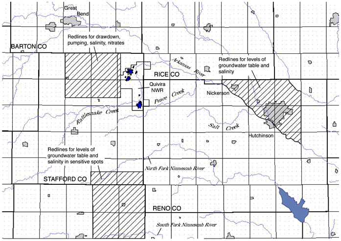
Adoption of redline restrictions seems to be an appropriate means for the preservation of groundwater resources in south-central Kansas. For the Hutchinson-Nickerson area and northern Stafford County, an outline for adequate redlines can be provided under current conditions. In these areas groundwater resources are threatened to such an extent that adoption of redlines--or some effective alternative program of resource protection--should be implemented promptly. It is not too late to adopt such redlines, but because of the long time constants and the irreversibility of the hydrologic system, delaying this action further could have serious consequences.
5.3 Remedial measures
Several remedial measures can be implemented in GMD5 and GMD2 to allow preservation of the quality of groundwater resources, and protection, at least partially, of regions subject to a high risk of loss of groundwater resources. However, implementation of any remedial measures should be adopted according to site-specific parameters and with great care.
5.3.1 Pumping saltwater
In some places pumping of saltwater can be considered. Such an approach could possibly be taken in a limited number of places in the Hutchinson-Nickerson area, where salt-mine wastes or oil brine has penetrated into the aquifer. There is also a longer-term possibility of pumping (with deep reinjection) from upgradient paleochannels or bedrock lows if these are identified and determined to be significant sources of deep saltwater intrusion. However, pumping of saltwater should not enhance penetration of other types of saltwater, e.g. from the Permian zone. Pumping of saltwater will probably be associated with pumping of freshwater. Therefore, adequate design and monitoring should be implemented to minimize quantities of freshwater lost during the pumping of the saltwater. The saltwater pumped could be disposed of by either discharge to the river or deep injection.
Saltwater could be pumped from the deep aquifer in northern Stafford County and conveyed by a pipeline into the Rattlesnake Creek or the Quivira marsh area, or to existing deep injection wells. Such pumping of saline water will decrease the tendency for saltwater upward migration into the shallow freshwater aquifer. However, pumping of saline water from the deep aquifer in Stafford County will probably lead to some losses of freshwater that may migrate from the freshwater aquifer into the deep aquifer. Due to the limited quantities of freshwater in that area, the effect of such losses may be detrimental to available quantities of freshwater in that area, and may conflict with efforts to keep the water table high enough for protection of stream discharge and regional heads.
An appropriate approach towards pumping of saltwater probably incorporates pumping of saltwater with artificial recharge of freshwater or wastewater after advanced treatment. Such an arrangement is considered for northern Stafford County in section 5.3.3 below.
5.3.2 Artificial recharge
Artificial recharge of groundwater may balance the quantities of freshwater that are taken out of the aquifer. However, balancing quantities of freshwater should be associated with reduction of solute materials, namely chloride content and nitrates. Otherwise the additional freshwater quantities do not improve the quality of groundwater. In rural areas of south-central Kansas groundwater quality parameters may be different for drinking and agricultural uses. For drinking, chloride content and nitrate concentration values need to be controlled. For agricultural uses, nitrate concentration is not an important parameter.
Groundwater recharge by treated wastewater may be a feasible alternative for northern Stafford County. Due to high rates of increase of nitrate concentrations, the shallow aquifer over much of this area is already or will soon arrive at the potable water nitrate concentration limit. Then the aquifer will be appropriate to use only for agricultural purposes. Under such conditions, injection of treated wastewater is a very good option for supplying the agricultural water needs, while mitigating effects of saltwater migration from the deep aquifer into the shallow aquifer. However, as discussed in the next section, the option of simultaneous pumping of saltwater and injection of treated wastes seems a better option for the preservation of the shallow aquifer for agricultural uses.
5.3.3 Simultaneous artificial recharge and pumping
The table below provides a basis for comparison of the relative volumes and qualities of water use and treated wastewater available for substitution or injection. Note that the magnitudes of the municipal waste water volumes are small, but not insignificant, compared to the larger water uses and needs, but are quite comparable to the volumes of saltwater entering from the bedrock. This--plus the fact that wastewater is elevated in salinity (and nitrate content) relative to good quality groundwater, but is much lower in salinity than the bedrock brine--suggests that an appropriate way to leverage the effect of wastewater recycling is to use it to replace or suppress the saltwater intrusion.
| Inventory/Flux Comparisons--Approximate Annual Volumes | |||||
|---|---|---|---|---|---|
| Pop. | Q (acre-ft/yr) |
Q (M3/yr) |
Cl conc. (mg/L) |
Notes | |
| Wastewater: | |||||
| Hutchinson | 40000 | 6300 | 7.8E+06 | 400 | |
| Nickerson | 1000 | 100 | 1.2E+05 | ||
| Great Bend | 15000 | 1800 | 2.2E+06 | 370 | |
| Total | 56000 | 8200 | 1.0E+07 | ||
| Water use: | Mostly groundwater | ||||
| Hutchinson-Nickerson Area | 16000 | 2.0E+07 | |||
| Northern Stafford County | 10000 | 1.2E+07 | not incl. QNWR | ||
| Permian Saltwater Inflow: | |||||
| Northern Stafford County | 2400 | 2.9E+06 | 40,000 | ||
| Quivira NWR water right | 14600 | 1.8E+07 | Surface water | ||
Northern Stafford County includes rural communities, but in view of the existing nitrate levels it is appropriate to consider, as a possible approach towards groundwater quality management, that in this area groundwater quality will satisfy only the agricultural parameters. Water for drinking purposes should be treated, mainly to reduce nitrate concentration. Such an approach should be considered as part of a large-scale reclamation project for the deep aquifer. The idea is to reclaim wastewater at least from the urban communities of Great Bend, and possibly Nickerson, Hutchinson, and others, and to convey the treated wastewater by a pipeline to Stafford County for injection into the deep aquifer, which is presently saline. Best results of the deep aquifer reclamation could be obtained if simultaneously with the groundwater recharge, identical quantities of saltwater will be pumped from the deep aquifer. If discharged into the Rattlesnake Creek the pumping might provide additional quantities of water to the Quivira Marsh area. The salinity of this water could be adjusted to the present level of Quivira Marsh intake salinity by diverting a compensating volume of the treated wastewater directly to the creek to mix with the pumped effluent, and/or by adjusting the volume pumped according to the streamflow available for dilution.
In such a manner quantities of groundwater resources available for agricultural uses will be effectively increased, because the progressive substitution of treated wastewater for deep aquifer saltwater will reduce the effects of salt upconing due to pumping. This will not only reduce aquifer contamination and permit sustained use of a greater volume of the presently freshwater aquifer, but it will also diminish the necessity for implementing restrictions on pumping to protect water quality. The current limitation on pumping from the freshwater shallow aquifer of northern Stafford County will be diminished, at the same time the water supply for the wildlife refuge can be protected and enhanced, and the environmental issue of municipal wastewater disposal will be addressed. Although considerable planning, preparation and investment would be required for such a program, its long-term effectiveness and "win-win" characteristics make it attractive to consider.
In the Hutchinson-Nickerson area, an obvious application of treated wastewater would be the creation of the head barrier just north of the Arkansas River by injection. It is likely that the head modification could be accomplished with less than the total wastewater volume available, even if the high salinity municipal waste flows are segregated. The balance of the wastewater could be applied to augment irrigation in the overall region, or it could be exported to augment the supply of low salinity water to more distant locations such as the Quivira refuge or northern Stafford County. The latter option would be economically costly in view of the distance and elevation over which water would have to be pumped, but should be considered as part of long-term regional management system because of the desirability of reducing the salt transported to GMD2 from GMD5.
Figure 15 illustrates some of the key features of how this system might be designed and operated. The proposed solutions can not be applied right away. However, they represent some innovative approaches that should be considered for establishing a long-term balance of salt and water quantities that will protect and insure water supplies in the different areas of south-central Kansas.
Figure 15. Schematic illustration of a potential integrated system of water resources management for south-central Kansas.
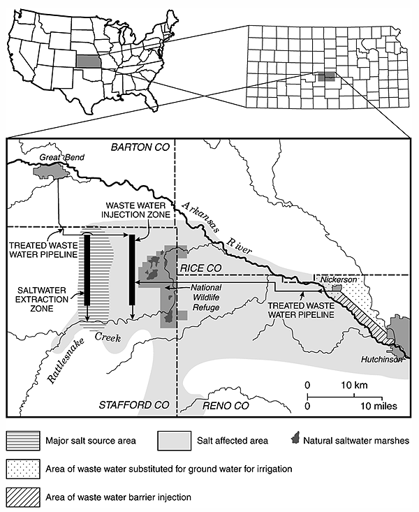
5.4 Preparation for future desalination
Various communities in the U.S. currently apply a variety of technologies for desalination to fulfill their needs for high quality drinking water. Many of the coastal communities in Florida and some in California have already taken such measures. The price to produce 35 ft3 (1 m3) of freshwater by desalination plant is about 60 cents. Urban areas can absorb such a price for drinking purposes, and even limited amounts of gardening, especially if the processed water is used for blending with a larger supply of marginal-quality water.
Under current conditions, application of desalination projects may look remote. However, in some urban communities, unless immediate and appropriate remedial measures are taken, the issue of a possible desalination solution to potable water needs may emerge in a few years. It is recommended at this stage to make initial studies of the possible use of desalination as a contributor to the potable water supply in south-central Kansas. Such actions may definitely be needed if future growth of urban communities is significant, or if the water supply deteriorates significantly. One of the benefits of moving to a regional water resource management system as recommended here is that it establishes a larger base of users and resources, making it more feasible to adopt strategies that require significant investments or regional trade-offs.
5.5 Comprehensive program of groundwater quality management
The preceding sections of this report indicate that a comprehensive program of groundwater quality management should be planned and adopted for south-central Kansas. Such a program should address budgets of water and pollutants, mainly chloride content and nitrate concentrations. Shifting of water of different qualities among the various uses should be considered.
Some examples of possible innovative ideas of management of the groundwater resources quality are provided in this report. The overall objective is a program that produces an optimum social and economic balance between economic development and the individual's freedom to choose his or her way of life, the ability of the limited natural resources to support both economic and environmental needs, and the public responsibility to preserve essential resources that are held and used in common by individuals and the community, now and in the future.
An appropriate strategy would be for the management and planning agencies to formulate lists of objectives for a program, and then to develop and introduce the appropriate means, including legislative authorizations, to move forward an appropriate program of groundwater quality management. An initial starting point might well be an electronic network for sharing and combining the relevant information held and produced by the various agencies involved in water issues within the region.
This work would not have been possible without the active participation and support of Equus beds Groundwater Management District No. 2. The authors also wish to acknowledge the cooperation and important contributions of GMD5, The US Bureau of Reclamation, the other state and local agencies contributing to the studies, and the cooperating landowners of the region.
KGS staff who contributed significantly to the projects included Don Whittemore, Mark Schoneweis, Melany Miller, and Sharon Vaughn. The Mineral Intrusion studies were funded in part by the Kansas Water Plan Fund.
Buddemeier, R.W., 1994. Overview and summary of FY94 mineral intrusion studies: Kansas Geological Survey: Kansas Geological Survey, Open-file Report 94-28a [available online]
Buddemeier, R.W., and Falk, S., 1994. Mineral intrusion issues and implications for monitoring and management: Kansas Geological Survey, Open-file Report 94-28g [available online]
Buddemeier, R.W., Garneau, G., Healey, J.M., Ma, T.-S., Young, D., and Zehr, D., 1993. The mineral intrusion project: Report of progress during fiscal year 1993: Kansas Geological Survey, Open-file Report 93-23
Buddemeier, R.W., Young, D.P., and Garneau, G.W., 1994a. Aquifer characteristics and hydrogeology: Kansas Geological Survey, Open-file report 94-28d [available online]
Buddemeier, R.W., Young, D.P., and Garneau, G.W., 1994b. Saltwater inventories and budgets: Kansas Geological Survey, Open-file Report 94-28e [available online]
Butler, J.J. Jr., Liu, W., and Young, D.P., 1993. Analysis of October 1993 slug tests in Stafford Pratt and Reno Counties: Kansas Geological Survey, Open-file Report 93-52
Cobb, P.M., 1980. The distribution and mechanisms of salt water intrusion in the fresh water aquifer and in Rattlesnake Creek Stafford County Kansas, M.S. thesis, Department of Civil Engineering, University of Kansas, Lawrence, Kansas.
Cobb, P.M., Colarullo, S.J., and Heidari, M., 1983. A groundwater flow model for the Great Bend aquifer south-central Kansas: Kansas Geological Survey, Open-file Report 83-3
Fader, S.W., and Stullken, L.E., 1978. Geohydrology of the Great Bend Prairie south-central Kansas, Irrigation Series 4, Kansas Geological Survey. [available online]
Garneau, G.W., Buddemeier, R.W., and Young, D.P., 1994. Characterization of the saltwater interface and related parameters: Kansas Geological Survey, Open-file report 94-28b [available online]
Garneau, G.W., Young, D.P., and Buddemeier, R.W., 1995. Freshwater-saltwater interface and related transition zone parameter characterization in the mineral intrusion area of south-central Kansas: Kansas Geological Survey, Open-file report 95-45a
Gillepsie, J.B., and Hagadine, G.D., 1993. Geohydrology and saline ground-water discharges to the South Fork Ninnescah River in Pratt and Kingman Counties south-central Kansas: U.S. Geological Survey, Water Resources Investigations, Report 93-4177 [available online]
Layton, D.W., and Berry, D.W., 1973. Geology and ground-water resources of Pratt County south-central Kansas: Kansas Geological Survey, Bulletin 205 [available online]
Ma, T.-S., and Sophocleous, M.A., 1994. Simulations of saltwater upconing in the Great Bend Prairie unconfined aquifer: Kansas Geological Survey, Open-file Report 94-28f [available online]
Ma, T.-S., and Sophocleous, M.A., 1996. Dynamic simulation of saltwater intrusion at the Siefkes site Stafford County Kansas and decision support for saltwater vulnerability assessment: Kansas Geological Survey, Open-file Report 96-18
Macfarlane, P.A., 1993. The effect of topographic relief and hydrostratigraphy on the upper part of the regional ground-water flow system in southeastern Colorado and western and central Kansas, with emphasis on the Dakota aquifer. PhD dissertation, University of Kansas, Lawrence, Kansas.
Macfarlane, P.A., 1995. The effect of river valleys and the upper Cretaceous aquitard on regional flow in the Dakota aquifer in the central Great Plains of Kansas and southeastern Colorado, Current Research on Kansas Geology, Kansas Geological Survey Bulletin 238, 11-30.
Macfarlane, P.A., 1996. An analysis of the upper part of the regional flow system along the southern ground-water flow "corridor" in the Dakota aquifer using a steady-state, vertical profile flow model: Kansas Geological Survey, Open-file Report 96-1d [available online]
Quinodoz, H.A.M., and Buddemeier, R.W., 1997. Budgets and fluxes of salt and water--model approaches and examples from the Great Bend Prairie and Equus Beds regions of south-central Kansas: Kansas Geological Survey, Open-file Report 96-25
Rubin, H., and Buddemeier, R.W., 1996. A top specified boundary layer (TSBL) approximation approach for the simulation of groundwater contamination processes: Journal of Contaminant Hydrology, vol. 22, p. 123-144. [available online]
Rubin, H., and Buddemeier, R.W., 1998a. Application of the top specified boundary layer (TSBL) approximation to initial characterization of an inland aquifer mineralization Part 1. Direct contact between fresh and saltwater: Journal of Contaminant Hydrology, vol. 32, 353-376. [available online]
Rubin, H., and Buddemeier, R.W., 1998b. Application of the top specified boundary layer (TSBL) approximation to initial characterization of an inland aquifer mineralization Part 2. Seepage of saltwater through semi-confining layers: Journal of Contaminant Hydrology, vol. 32, 377-402. [available online]
Rubin, H. and Buddemeier, R.W., 1997. Approximate analysis of aquifer mineralization by paleodrainage channels: Kansas Geological Survey, Open-file Report 97-96, Kansas Geological Survey, University of Kansas, Lawrence, Kansas.
Rubin, H. and Buddemeier, R.W., 1998c. Approximate analysis of groundwater mineralization due to local discontinuity in impermeable layer; Part 1: Direct contact between fresh and saltwater: Kansas Geological Survey, Open-file Rept. No. 98-31
Rubin, H. and Buddemeier, R.W., 1998d. Approximate analysis of groundwater mineralization due to local discontinuity in impermeable layer; Part 2: Seepage of saltwater through semiconfining discontinuity: Kansas Geological Survey, Open-file Rept. No. 98-32
Rubin, H. and Buddemeier, R.W., 1998e. Approximate analysis of aquifer mineralization due to horizontal penetration of salinity: Kansas Geological Survey, Open-file Rept. No. 98-33
Sophocleous, M.A., 1991. Stream-floodwater propagation through the Great Bend alluvial aquifer Kansas--Field measurements and numerical simulations, Journal of Hydrology, 124: 207-228.
Sophocleous, M.A., Townsend, M.A., Volger, L.D., McClain, T.J., Marks, E.T., and Coble, G.R., 1987. Stream-aquifer testing of the Arkansas River alluvial aquifer near Great Bend central Kansas: Kansas Geological Survey, Open-file Report 87-2
Young, D.P., 1995. Effects of groundwater pumpage on freshwater-saltwater transition zone characteristics water quality and water levels at the Siefkes intensive study site--Stafford County Kansas: Kansas Geological Survey, Open-file Report 95-45c
Young, D. and Rubin, H., 1998. Determining vertical flow in variable density groundwater--a hydrostatic approach applied in south-central Kansas, Eighteenth Annual Hydrology Days, Colorado State University, Fort Collins, Colorado, March 30-April 3, 1998.
Young, D.P., Garneau, G.W., Buddemeier, R.W., Zehr, D., and Lanterman, J., 1993. Elevation and variability of the freshwater-saltwater interface in the Great Bend Prairie aquifer--south-central Kansas: Kansas Geological Survey, Open-file Report 93-55
Young, D.P., Garneau, G.W., Whittemore, D.O., Zehr, D., and Lanterman, J., 1994, Temporal variations in the amount and distribution of saltwater and freshwater: Kansas Geological Survey, Open-file Report 94-28c [available online]
Young, D.P., Garneau, G.W., Buddemeier, R.W., Zehr, D., and Lanterman, J., 1995a. Variability of freshwater-saltwater transition zone characteristics and related parameters in the Great Bend Prairie aquifer--south-central Kansas: Kansas Geological Survey, Open-file report 95-45b
Young, D.P., Healey, J.M., and Whittemore, D.O., 1995b. Initial monitoring results and installation details from the Witt intensive study site on Rattlesnake Creek Stafford County Kansas: Kansas Geological Survey, Open-file Report 95-45d
Young, D.P., Buddemeier, R.W., and Zehr, D., 1996. Mineral Intrusion Project final data report. Open-File Report 96-24
Young, D.P., Whittemore, D.O., Buddemeier, R.W., Kochi, D.R., Dealy, M.T., and Hagardine, G.D., 1997. Groundwater monitoring network for the Equus Beds aquifer mineral intrusion study--description and initial monitoring results: Kansas Geological Survey, Open-file Report 97-39
Young, D.P., Buddemeier, R.W., Whittemore, D.O., Dealy, M., Kochi, D., Boese, T., Zehr, D., 1998. Equus Beds mineral intrusion project report FY 1998: Kansas Geological Survey, Open-file Report 98-24
Young, D. P., Buddemeier, R. W., Whittemore, D. O., and Rubin, H., 2000. Final summary and data report: the Equus Beds Mineral Intrusion project: Kansas Geological Survey Open-File Report 2000-30. Available online.
Kansas Geological Survey, Equus Beds Mineral Intrusion Project
Placed Online April 2001
Comments to webadmin@kgs.ku.edu
The URL for this page is HTTP://www.kgs.ku.edu/Hydro/Equus/OFR00_60/index.html