Kansas Geological Survey, Open-file Report 2000-30
Part of the Equus Beds Mineral Intrusion Project
Kansas Geological Survey, University of Kansas
KGS Open File Report 2000-30
March, 2001
Contents:
This report, along with its companion report, KGS OFR 2000-60 (Rubin et al., 2000) is the final contract report to the Kansas Water Office, summarizing and transmitting the data acquired and the major findings and recommendations resulting from the KGS participation in the multi-agency Equus Beds Mineral Intrusion Project. This report presents the data collected within a summary overview framework, providing basic discussion and illustration of the project results and technical findings. OFR 2000-60 presents a more detailed discussion and recommendations regarding groundwater quality management, based on the data presented here.
The EBMI project was a joint activity of the Equus Beds Groundwater Management District No. 2 (Michael Dealy, manager), the U.S. Bureau of Reclamation (Tom Pruitt, Principal Investigator); the Kansas Geological Survey (R. W. Buddemeier, D. P. Young, D. O. Whittemore), and the Kansas Water Office (KWO), with funding by GMD2, USBR, and the State Water Plan Fund of the Kansas Water Office; and advice and review by an interagency Task Force chaired by GMD2 and consisting of representatives of the Kansas Water Office, the U. S. Geological Survey (Kansas District), the City of Hutchinson, the City of Nickerson, Reno County Health Department, Big Bend Groundwater Management District No. 5, Kansas Department of Health and Environment, and the Lower Arkansas Basin Advisory Committee (Kansas Water Authority).
Format: This report is derived from a project web site, and is prepared and presented in html format. It may be viewed and/or printed with any standard browser. The electronic medium is also used for distributing tabulations and summaries of results not in html format. In the body of the report, a normal link operates within the html environment. A link that is followed by a 3-letter file suffix code (extension) in parentheses [e.g., (.pdf), (.xls), (.doc)] indicates a link to a file in some other format that will NOT open automatically with an html browser. It can be downloaded in any case, or opened IF the user has the appropriate software and browser settings.
As is the practice with all such project reports, this is presented in draft final format for contract compliance, with the provision that it will remain open for review by the funding agency and other project participants for a period of 30-60 days. If no corrections or amendments are requested it will be considered final. If corrections or amendments are requested by cooperating agencies, a modified version will be released with the same title and report number, but with an updated version number and date of release.
South-central Kansas contains a wide area that is actually or potentially subject to salt contamination of fresh groundwater and surface water. Figure 1 provides a schematic overview of the major areas involved.
Figure 1. Areas affected by or vulnerable to salt contamination in south-central Kansas.
From: Salt Contamination of Groundwater in South-Central Kansas, Public Information Circular No. 2, Kansas Geological Survey
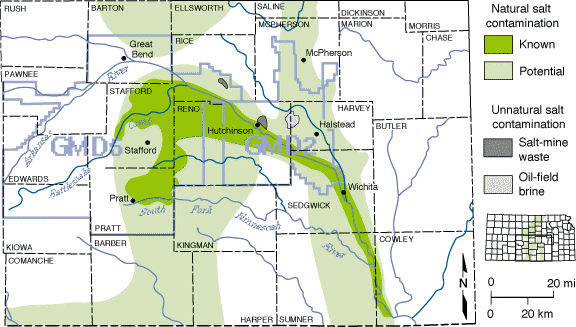
There are a number of salt sources involved. Some of the contamination is completely natural, arising from the dissolution of salt deposits, or of salt cements in the Permian-age bedrock underlying much of the area. Locally, waste from salt mining or oil production activities has caused hot spots and plumes of enhanced contamination. Other minor sources include such human activities as water-softener salt discharge, road de-icing, and salinization of shallow groundwater as a result of irrigation. These latter sources are detectable, but the large scale regional problems stem from naturally occurring salt in the area.
Although the salt, and some salt contamination, is naturally occurring, there is concern about the possibility that human activities such as fresh water extraction may be altering the flow patterns or discharge rates of the natural salt in ways that pose long-term threats to freshwater regions not presently contaminated. The study reported here was motivated by specific concerns about the water supplies of the cities of Hutchinson (see map above) and Nickerson (northwest of Hutchinson, also on the north side of the Arkansas River). Both communities depend on groundwater wells relatively close to the river, which has conventionally been regarded as a barrier to northward migration of saline water from the south. However, groundwater development north of the river has lowered the water table there, while the unusable saline water to the south retains its natural head. The potential for enhanced intrusion of salt into the fresh groundwater areas north of the river has been investigated by both field studies and modeling, reported on below.
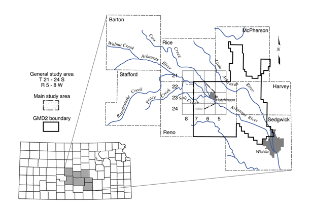
The general region of interest for the study was a 16-township block centered between the cities of Hutchinson and Nickerson (see Figure 2). The greatest attention, and almost all of the field investigation, was devoted to about half of the total area near the center of the general study block. However, modeling, data assembly and general review of sources and transport of salt extended well beyond the defined boundaries.
Figure 2. Location of main study area inside general study area (township-range grid) and study region (7 county area).
Field Investigations
In order to monitor water quality and head at different depths and locations within the aquifer a network of 41 monitoring wells at 21 sites was installed for groundwater data collection (Figure 3). The wells were installed by the U.S. Bureau of Reclamation in September 1997-January 1998. They were logged by KGS to provide information on the sediments that comprise the aquifer, the salinity distribution at the different locations, and the depth to bedrock. GMD2 sampled the wells at regular intervals throughout the study to provide water level records and salinity samples. Well locations are shown in the map below; sites 250-270 are the locations installed for this study, while the lower numbers shown indicate wells available for project use that were installed for an earlier study.
Figure 3. Locations of groundwater monitoring sites (solid circles) and transects and surface water data collection points (triangles) in the EBMI study area. See Figure 2 for grid location.
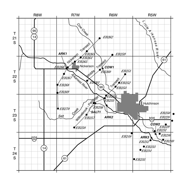
The monitoring well sites are aligned in transects approximately perpendicular to the Arkansas River. Sites 262-270 are referred to as the Nickerson Transect, 259-261 as the Middle Transect (north of the river only), and 251-258 as the Willowbrook-Partridge Transect. The map below includes the labeled transects and surface water data collection sites (ARK1, ARK2, ARK3, COW1, COW2, and SALT1).
Each monitoring site has at least one well screened in the Equus Beds aquifer. Most sites consist of two or more wells completed at different depths in the aquifer. Nearly all the sites have a deep well, the "C" well, completed directly above bedrock. Some sites have a well of intermediate depth in the aquifer, the "B" well. Most sites have at least one well of shallow to intermediate depth, the "A" well. And one site has four wells; the shallowest well has the designation "AA".
Table 1 summarizes basic well and site information, including monitoring site and well ID, legal location, land surface elevation, depth to bedrock, bedrock surface elevation, and screened intervals. Surface elevations were measured by the U.S. Bureau of Reclamation using a Global Positioning System (GPS).
Table 1. Well and site information
| ID | Land Elev. (ft) |
Depth to Bedrock (ft) |
Bedrock Elev (ft) |
Screen Depth (ft) |
Gravel pack (ft) |
Location |
|---|---|---|---|---|---|---|
| EB250C | 1496.49 | 67 | 1429.5 | 57-67 | 57-71 | 23-04W-19BAA |
| EB250A | 38-48 | 34-48 | ||||
| EB251C | 1627.26 | 65 | 1562.3 | 52-62 | 52-70 | 22-06W-14DDD |
| EB251A | 20-30 | 20-32 | ||||
| EB252C | 1556.28 | 66 | 1490.3 | 56-66 | 52-71 | 22-06W-27AAA |
| EB252A | 37-47 | 33-49 | ||||
| EB253C | 1554.71 | 61 | 1493.7 | 49.5-59.5 | 46-62.5 | 22-06W-27CD |
| EB254C | 1555.46 | 46 | 1509.5 | 36-46 | 31-50.5 | 23-06W-05AAA |
| EB255C | 1556.48 | 75 | 1481.5 | 63-73 | 58-73 | 23-06W-05ACC |
| EB255A | 20-30 | 18-30 | ||||
| EB256C | 1563.60 | 85 | 1478.6 | 74-84 | 72-90 | 23-07W-12ADA |
| EB256B | 51-61 | 48-62 | ||||
| EB256A | 12-22 | 11-22 | ||||
| EB257C | 1602.24 | 186 | 1416.2 | 176-186 | 171-189 | 23-07W-23AAB |
| EB257B | 140-150 | 135-150 | ||||
| EB257A | 84-94 | 79-94 | ||||
| EB258B | 1614.07 | 127 | 1487.1 | 96-106 | 92-108 | 23-07W-33AAA |
| EB258A | 64-74 | 57-75 | ||||
| EB259B | 1696.84 | 106 | 1590.8 | 75-85 | 70-89 | 21-06W-33DDD |
| EB259A | 10-20 | 10-20 | ||||
| EB260C | 1573.99 | 73 | 1501.0 | 63-73 | 58-77 | 22-06W-18AAA |
| EB261C | 1581.32 | 120 | 1461.3 | 112-122 | 105-122 | 22-07W-23DDD |
| EB261A | 20-76 | 10-76 | ||||
| EB262C | 1650.06 | 2 | 1648.1 | 55-65 | 50-69.5 | 21-06W-19AAA |
| EB263C | 1590.02 | 67 | 1523.0 | 56-66 | 51-71 | 21-07W-35AAA |
| EB264C | 1593.84 | 55 | 1538.8 | 45-55 | 40-55 | 22-07W-03AAA |
| EB264A | 20-51 | 10-51 | ||||
| EB265C | 1594.96 | 55 | 1540.0 | 44.5-54.5 | 39.5-60 | 22-07W-04DDD |
| EB266B | 1601.24 | 108 | 1493.2 | 85-95 | 80-95 | 22-07W-08DCD |
| EB266A | 37-47 | 33-49 | ||||
| EB267C | 1634.04 | 206 | 1428.0 | 196-206 | 191-206 | 22-07W-17CCC |
| EB267B | 105-115 | 100-115 | ||||
| EB267A | 63-73 | 59-73 | ||||
| EB268C | 1638.84 | 152 | 1486.8 | 141.5-151.5 | 137-155 | 22-07W-30BCC |
| EB268B | 88-98 | |||||
| EB268A | 33-43 | 28-46 | ||||
| EB269C | 1634.75 | 187 | 1447.8 | 177-187 | 173-191.5 | 22-07W-31CCC |
| EB269B | 101-111 | 97-114 | ||||
| EB269A | 35-45 | 31-47 | ||||
| EB270C | 1625.30 | 170 | 1455.3 | 160-170 | 160-174 | 23-07W-18BBB |
| EB270B | 127-137 | 123-138 | ||||
| EB270A | 82-92 | 77-95 | ||||
| EB270AA | 40-50 | 35-54 |
General Geology
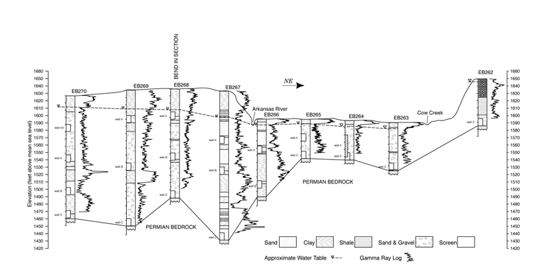
The aquifer is composed primarily of unconsolidated Quaternary deposits of sand and gravel interbedded with layers or lenses of silt and clay; the thickness and character of the materials is variable. Generally the aquifer overlies bedrock of Permian age, however bedrock of Cretaceous age may be found in the northern part of the general study area. The heterogeneity of the aquifer is evident in hydrogeologic cross sections (Figures 4 and 5), which are based on well logs from the new monitoring sites. In the Arkansas River valley, the deposits consist of fairly extensive sand and gravel beds, separated by clays in places. A near-surface clay layer is common. The sediments generally are thicker south of the Arkansas River. Notice the bedrock lows at site EB257 in the Willow Brook-Partridge section and at site EB267 in the Nickerson section (Figures 4 and 5). These sites are located where the ancestral Arkansas River eroded a channel into the Permian bedrock.
Figure 4. Hydrogeologic section through Willowbrook-Partridge transect.
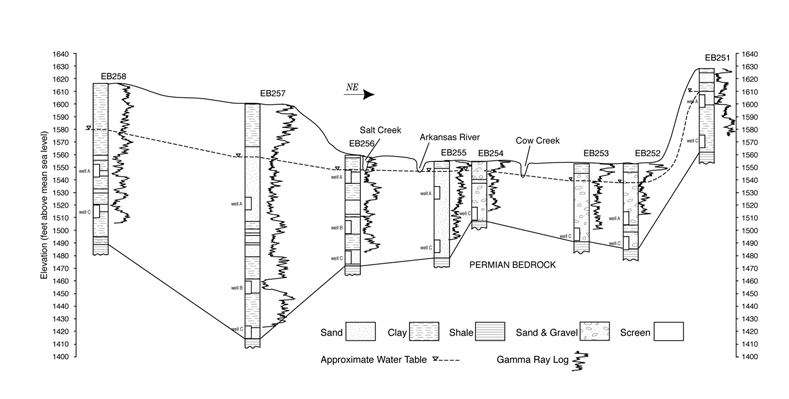
Figure 5. Hydrogeologic section through Nickerson transect.
Groundwater Levels
Water levels in the monitoring wells were measured approximately monthly. Depth-to-water measurements and water-level elevations are listed in Table 2. The table is available for download in MS Excel spreadsheet format: 2000-30_AppB.xls. Click below to view well hydrographs from each of the sites.
Depth-to-water measurements for the new monitoring wells range from above land surface to about 40 feet below land surface. The water table is shallower north of the Arkansas River, and is within 10 ft of land surface at most sites north of the river. The water table was within 1 ft of land surface at site EB259 on March 31, 1998. Artesian conditions occur at site EB262, and the water level was above land surface on that same date. The well at site EB262 is screened in Cheyenne Sandstone. Depth to water is greatest, approximately 40 ft below land surface at sites EB257 and EB258, the southernmost sites in the Willowbrook-Partridge transect.
Similar patterns are observed on most hydrographs. The highest water levels in most wells were observed in the spring of 1998 (generally in March, when a lot of precipitation fell). Water levels were generally lowest in July and August of 1997. Water levels in some wells, particularly north of the river, show drawdowns caused by nearby groundwater pumping, most of which occurs during the summer months. At the southernmost sites in the Nickerson transect (EB269 and EB270), water levels were lowest in May of 1997. These wells are located the farthest from water rights locations, and thus are the least affected by groundwater pumping.
At sites with more than one well, water-level changes were generally synchronous in the different wells, particularly north of the Arkansas River. In fact, north of the river, where clay lenses are less common, virtually no vertical hydraulic gradient was observed at most of the sites, indicating very good vertical hydraulic connection. Exceptions are sites EB266 and EB261, which are located just north of the River, where upward vertical hydraulic gradients were observed.
At sites south of river, where clay layers or lenses are more widespread (see Figures 4 and 5), water-level fluctuations were less synchronous in wells of different depths. At site EB257, the water level in the C well rose above those in the A and B wells in October of 1997, and has remained above except for a short period in 1998, resulting in conditions favorable for upward flow. Upward vertical hydraulic gradients also occur at sites EB256, EB267 and EB270. These observations could be signs of semiconfined conditions, which could have significant implications for the lateral transport of salt and water.
Higher water-level elevations in deeper wells could also be a reflection of a high Permian head, which in turn could relate to increased local bedrock discharge. Boreholes were generally drilled a few feet into bedrock for freeboard to ensure that screens could be placed as close to the bedrock contact as possible. Most of the sites with upward gradients are located near the Arkansas River or Salt Creek, and are indicative of groundwater discharge zones.
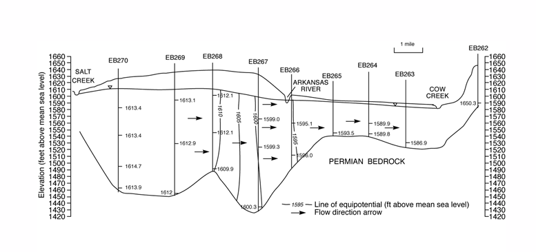
The hydrogeologic cross sections in Figures 6 and 7 show the water-level elevation plotted at the midscreen of each well, and inferred equipotential lines and flow arrows. The water-level data from March of 1998 were used to coincide with the time of water sample collection. Similar patterns were observed for sections produced using March 1997 and November 1997 data. Although lithologic variations were not considered and would actually alter the flow arrows, these sections show evidence of a northeastward component of flow, including under the Arkansas River. This has great implications for transport of salt water into the freshwater aquifer north of the river, which will be discussed in subsequent sections of this report.
Figure 6. Hydrogeologic section through Willowbrook-Partridge transect showing inferred equipotentials and flow arrows. Water-level data from Spring 1998.
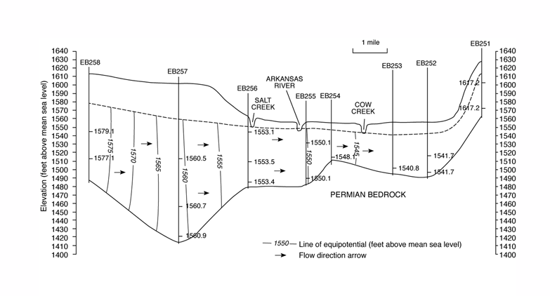
Figure 7. Hydrogeologic section through Nickerson transect showing inferred equipotentials and flow arrows. Water-level data from Spring 1998.
Groundwater Quality
Four sets of samples were collected from the EBMI monitoring wells: Spring and Fall of 1997 and 1998. Two existing monitoring wells within the study area (EB400C and EB401C) were also sampled, as well as the monitoring wells just east of Hutchinson comprising part of the earlier Hutchinson to Wichita salinity study. Waters were also collected from 3 sites on the Arkansas River, two sites on Cow Creek, and one site on Salt Creek. Analyses of the surface waters will be discussed in a subsequent section. Samples were shipped to the Kansas Geological Survey for analysis. Procedures for the sampling and analyses, and results from the Spring '97 sampling were presented by Young et al. (1997) and will not be repeated in this report.
The groundwaters from the EBMI wells range from very fresh to highly saline. Chloride concentrations ranged from 2 mg/L in EB259B to 5,812 mg/L in the Spring '98 sample from EB257C. Where saline waters occur, the salinity increases with depth as indicated by sites with wells completed at multiple levels. The exception is site EB267, where the intermediate well has a higher chloride concentration than the deepest well. Some sites contain freshwaters of similar salinity at different depths. The waters with the highest salt contents occur south of the Arkansas River, confirming that groundwater salinities are greater in that region. The most saline water is from a well (EB257C) screened in a bedrock channel in the southern part of the study area. Note that there are contaminant plumes beneath parts of Hutchinson and vicinity that are being monitored by the Kansas Department of Health and Environment; these are not discussed in this report.
Chemical Characteristics
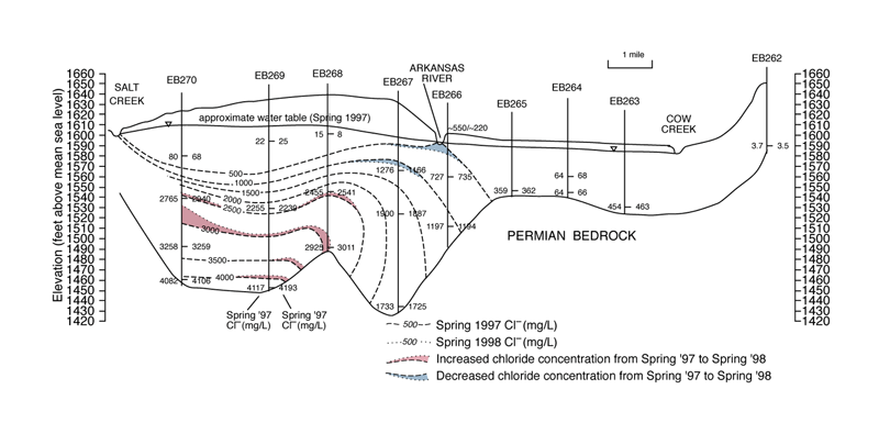
The hydrogeologic sections presented in Figures 8 and 9 illustrate with contours the distribution of chloride and the changes in chloride concentration from Spring '97 to Spring '98. These figures show that groundwaters are generally fresh north of the Arkansas River. Exceptions to this are wells at sites just north of the river (EB255C, EB261C, and EB266A & B), which have chloride concentrations greater than 500 mg/L. Concentrations in this range are above the recommended drinking water standard of 250 mg/L, and are not recommended for irrigation. Elsewhere north of the river, groundwater samples yielded fresh water, except in wells EB263C, which had a chloride concentration as high as 484 mg/L in the Fall '97 sample, and EB265C, where the concentration was steady at 360 mg/L.
Figure 8. Hydrogeologic section through Willowbrook-Partridge transect showing changes in inferred distribution of chloride--Spring '97 to Spring '98.
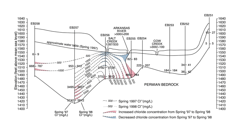
Figure 9. Hydrogeologic section through Nickerson transect showing changes in inferred distribution of chloride--Spring '97 to Spring '98.
Examination of the chemical data indicates that there is a wide range in the chemical character of the ground and surface waters. For example, sulfate/chloride ratios differ substantially for some of the saline groundwaters. Nitrate concentrations range from undetectable to over the maximum contaminant limit of 45 mg/L for water from wells EB254C, EB255A, EB258A, EB268A, and EB270AA in the network. In general, nitrate concentrations decreased with depth for sites with multiple-level wells. The chemistry of water from site EB263C indicates that oil-field brine could contribute a major portion of the chloride concentration, which averaged 467 mg/L.
The chemical data also show some interesting temporal changes in some the wells (see links to specific conductance, chloride, sulfate, and nitrate-N tables). Changes in chloride concentration between the four sampling times were perhaps most noteworthy in well EB255C. This well is located north of the Arkansas River. In that well, the chloride concentration increased 255 mg/L from Spring '97 to Spring '98 (from 489 mg/L in Spring '97, to 643 mg/L in Fall '97, to 744 mg/L in Spring '98). Notice the shift in the 500 mg/L chloride contour on the chloride cross section above. These changes indicate possible penetration of salinity from the south of Arkansas River to the north of the river. However, the concentration dropped to 415 mg/L in the Fall '98 sample. These changes also indicate a fragile interface between the saltwater and freshwater.
Chloride concentrations at the other monitoring sites bordering the river on the north remained fairly consistent for the four sampling times in 1997 and 1998, with one exception: well EB261A averaged about 220 mg/L; EB261C dropped from 892 mg/L to 786 mg/L, EB266A averaged about 735 mg/L, and EB266B remained about 1,200 mg/L. Changes of chloride content originate from changes in the equilibrium between fluxes of the aquifer, fluxes induced by the presence of the Arkansas River, artificial pumping, and natural recharge.
Chloride concentrations increased in many deep wells south of the Arkansas River, particularly in EB256C, EB257C, EB268B&C, EB269C, (and EB248C, which is located south of Hutchinson, east of the main study area). From Spring 1997 to Spring 1998, chloride concentration showed a net increase in the deepest well at all sites south of the Arkansas River except at site EB267. However, concentrations in most of those wells decreased in the Fall 1998 sample. Well EB270A showed an increase in chloride concentration from 2,765 mg/L in Spring 1997 to 2,940 mg/L in Spring 1998, then to 3062 in Fall 1998, possibly a local phenomenon, due to local release of chloride. The steep bedrock slope near site EB270 could be conducive to bedrock discharge, especially if relatively permeable horizons are exposed.
A significant decrease in chloride concentration from 2046 mg/L in Spring 1997 to 1688 mg/L in Spring 1998 occurred in EB256A, adjacent to the Salt Creek collection point (SALT1). The concentration in Salt Creek decreased from 1287 to 333 mg/L. These declines resulted from dilution by the heavy precipitation.
The complete set of water quality measurements assembled for the project is available for download in the form an MS Excel spreadsheet: ebmiqual.xls.
Surface Water
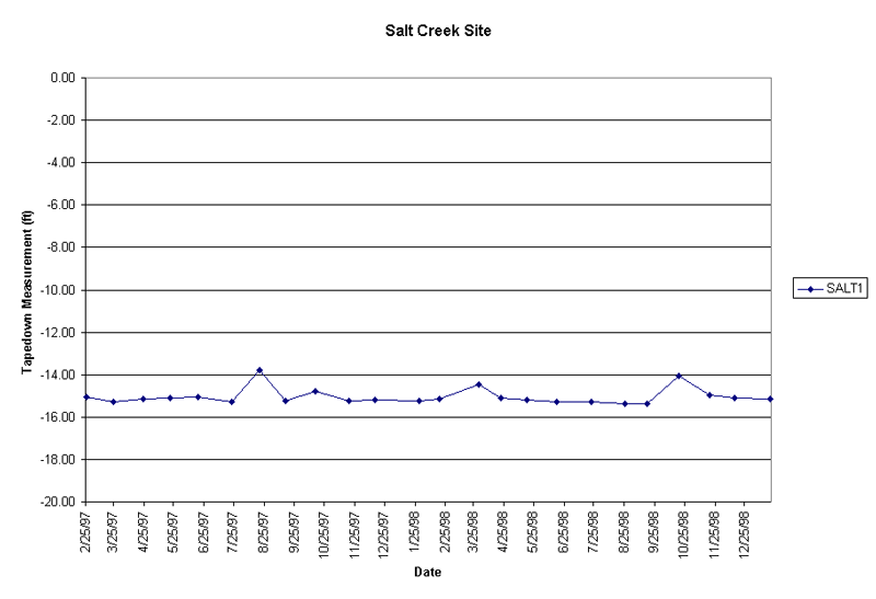
The primary surface water data collection points include three on the Arkansas River (ARK 1, ARK 2, and ARK 3), two on Cow Creek (COW 1 and COW 2), and one on Salt Creek (SALT 1); their locations are shown in Figure 3. ARK 1 is adjacent to monitoring site EB266 and SALT 1 is adjacent to EB256. Stream levels were determined by monthly tapedown measurements from bridges. Click on the link below to see the data from surface water collection points.
Table of Data from Surface Water Collection Points
Peak stream levels were observed at all but one surface site in August of 1997 and March of 1998, primarily in response to locally heavy precipitation (see Figures 10-12). Cow Creek at COW 1 was flooded at the time of these observations. The peaks at COW 2 (downstream from Hutchinson) are generally subdued and delayed relative to those at COW 1 due to flood-control features in and around Hutchinson.
Figure 10. Hydrographs from Arkansas River data collection points.
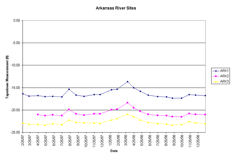
Figure 11. Hydrographs from Cow Creek data collection points.
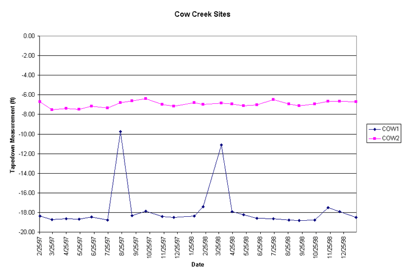
Figure 12. Hydrographs from Salt Creek data collection point.
Water-quality data collected for the project include the four sets of samples at the surface-water collection points (see links to water quality tables below), quarterly specific conductance and chloride determinations by GMD2 (surface water data table), and results of a Salt Creek conductivity survey (discussed below). The complete water quality measurements assembled for the surface water sites are available for download in the form an MS Excel spreadsheet: ebmiqual.xls. The table links below list changes between the four sampling times for specific conductance, chloride, sulfate, and nitrate, respectively.
Data Values
Figure 13 shows chloride concentrations for the four sampling times. For the 1997 samples, Salt Creek (SALT 1) had more than twice the chloride concentration of any other surface site, 1,287 mg/L in the spring and 1198 mg/L in the fall. Chloride concentrations were similar for the three Arkansas River sites in 1997, and dropped from about 550 mg/L in the spring to slightly above 450 mg/L in the fall. The 1997 spring and fall chloride concentrations were 325 and 233 mg/L at COW 1, and 545 and 450 mg/L at COW 2.
Figure 13. Chloride concentrations and changes from surface water data collection points.
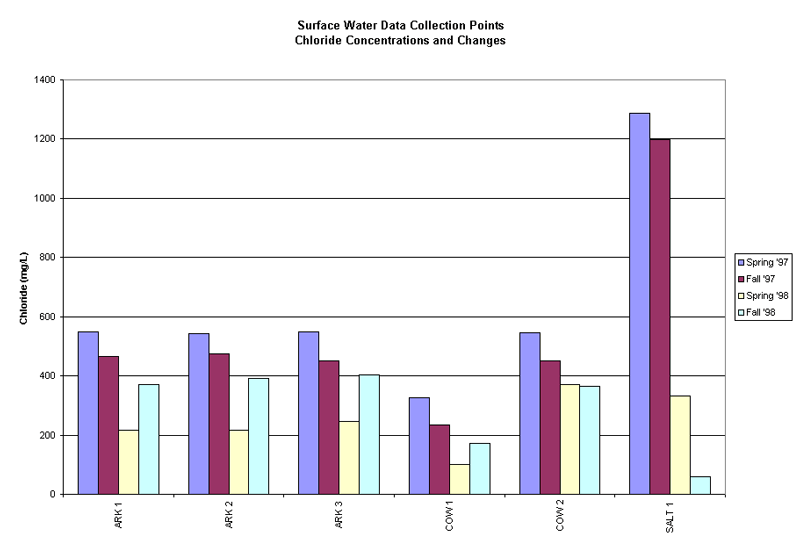
All Spring '98 surface water samples had lower salinity than previous samples due to dilution from precipitation. Specific conductance and chloride were well correlated on Cow and Salt Creeks, but not on the Arkansas River, indicating different salinity source areas: western Kansas/eastern Colorado for sulfate in the Arkansas River water compared the more local source areas for chloride in Salt and Cow Creeks. On the subject of sources, the chloride content at COW 1 appears to have a contribution from oil brine.
A Salt Creek conductivity survey was undertaken on October 23, 1997. Specific conductance was measured at ten locations on Salt Creek and on one tributary, Sugar Creek, to determine variations in salinity. The stretch of the creek surveyed was from the K14 bridge to the 4th Street bridge just west of Hutchinson. Unfortunately, conditions were wet and the salinity was diluted somewhat from freshwater runoff. However some interesting observations were made. Increases in conductivity were observed in very localized reaches of the stream; these areas were where the stream flows in a generally southeastward direction, or has a southward component of flow. In the mile east of K14, the conductivity increased from 2120 to 3520 µS/cm, and in the vicinity of EB256, it increased from 3520 to 4460 µS/cm in about 2 miles. Little or no net increase was observed elsewhere. Another observation, based on these measurements, is that Sugar Creek is at least as saline as Salt Creek (but it does has a lower flow). The conductivity measurement on Sugar Creek was higher than those on Salt Creek near their confluence. This may imply that some of the smaller tributaries play an important part in the salt budgets.
Mineral intrusion issues in the Equus Beds region are part of a larger natural system that extends beyond the borders of the study area. This section briefly discusses and illustrates some of the larger contexts, which are discussed and developed by Rubin et al. (2000).
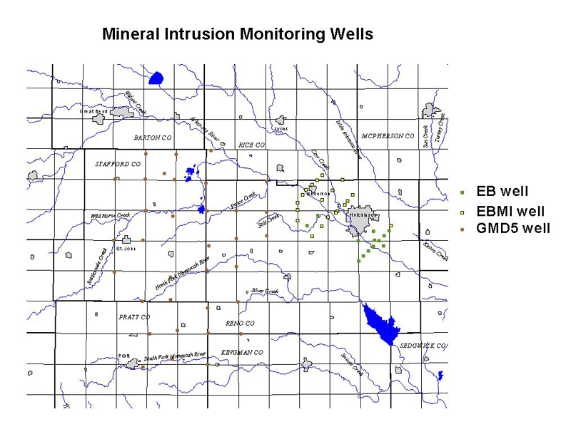
The "Mineral Intrusion Monitoring Wells" figure below shows the extent of previous monitoring and assessment activities in both GMD2 and GMD5; the wells labeled EBMI are the sites installed specifically for the present project.
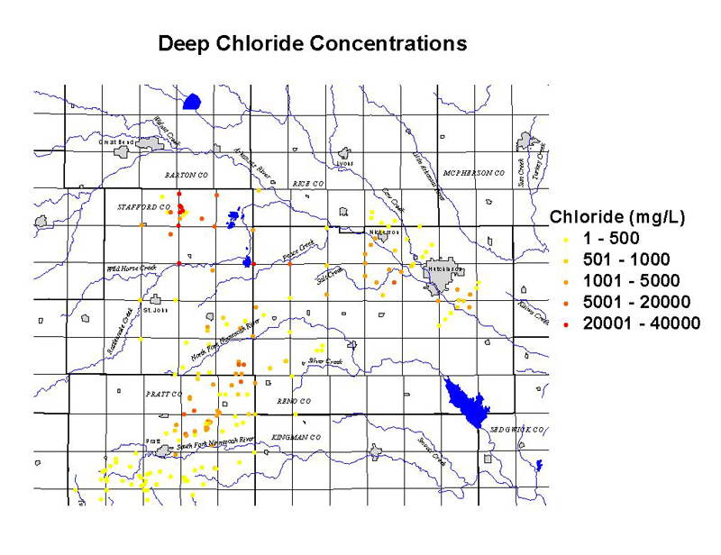
The monitoring wells shown above, plus a large number of other wells, are the source of the data on "Deep Chloride Concentrations" shown in the following figure. This figure focuses on data describing salinities in the deeper part of the alluvial aquifer just above the Permian bedrock. It depicts the wide-ranging distribution of high salinities, and illustrates that although the EBMI study area involves the greatest population centers, it is not the most heavily affected region in terms of actual water quality.
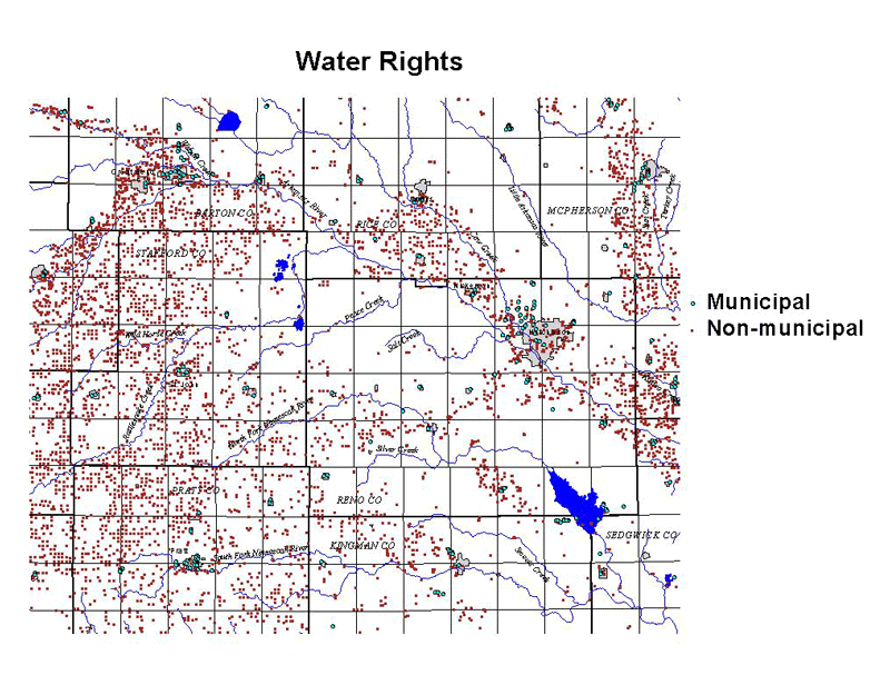
The map of "Water Rights" shown below was extracted from DWR databases, and illustrates the impact of the high salinities found in eastern Stafford, southwestern Rice, and Reno counties south of the Arkansas River. Over most of these areas, saturated thickness is adequate to support groundwater use, but water quality is unacceptable. Ground water flow in the region is generally west-to-east, so the position of the municipal wells around Hutchinson and Nickerson places them downgradient from the major salt sources in terms of regional flow patterns. The function of the Arkansas River as a barrier to salt penetration is critical to maintaining these supplies (see Rubin et al., 2000).
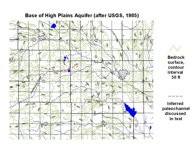
Sources of salt input to the study area are an important consideration in assessing both remediation and protection measures and the time constants of system change. Quinodoz and Buddemeier (1997) evaluated the budgets of salt in, and fluxes from, the GMD5 study areas, and in particular estimated the groundwater transmission of salt into western GMD2. Young et al. (1998) performed similar calculations for the region of western GMD2 south of the Arkansas River. Although uncertainties are high, the estimates suggest that local penetration from the Permian bedrock in GMD2 and downgradient flow from sources in GMD5 may have comparable contributions to salinity in the GMD2 area. Sources are not uniformly distributed, but are probably associated with lows and paleochannels in the bedrock surface. Bedrock topography is shown below, with the suspected location of a paleochannel paralleling part of Rattlesnake Creek. The fact that it is oriented parallel to the groundwater flow direction means that it has the potential to serve as conduit for relatively rapid, long-distance transport of high-salinity water (Rubin et al., 2000). Considerations such as this need to be taken into account in any further assessment or management planning.
The hydrologic and geochemical connections among the various components of the south-central Kansas interactive groundwater-surface water system, and the sensitivity of water quality to alterations in either surface- or groundwater flow regime, suggest that this is an area that could benefit from a long-term regional management program. Some possible approaches to such a program are discussed in the companion report, KGS OFR 2000-60 (Rubin et al., 2000).
The references below include a general list of papers and reports relevant to the project, as well as any publications specifically cited in the text of this report.
Buddemeier, R.W., 1994. Overview and summary of FY94 mineral intrusion studies: Kansas Geological Survey, Open-File Report 94-28a [available online]
Buddemeier, R.W., and Falk, S., 1994. Mineral intrusion issues and implications for monitoring and management: Kansas Geological Survey, Open-File Report 94-28g [available online]
Buddemeier, R.W., Garneau, G., Healey, J.M., Ma, T.-S., Young, D., and Zehr, D., 1993. The mineral intrusion project: Report of progress during fiscal year 1993: Kansas Geological Survey, Open-File Report 93-23
Buddemeier, R.W., Young, D.P., and Garneau, G.W., 1994a. Aquifer characteristics and hydrogeology: Kansas Geological Survey, Open-File Report 94-28d [available online]
Buddemeier, R.W., Young, D.P., and Garneau, G.W., 1994b. Saltwater inventories and budgets:Kansas Geological Survey, Open-File Report 94-28e [available online]
Butler, J.J. Jr., Liu, W., and Young, D.P., 1993. Analysis of October 1993 slug tests in Stafford Pratt and Reno Counties: Kansas Geological Survey, Open-File Report 93-52
Cobb, P.M., 1980. The distribution and mechanisms of salt water intrusion in the fresh water aquifer and in Rattlesnake Creek Stafford County Kansas: M.S. thesis, Department of Civil Engineering, University of Kansas, Lawrence, Kansas.
Cobb, P.M., Colarullo, S.J., and Heidari, M., 1983. A groundwater flow model for the Great Bend aquifer south-central Kansas: Kansas Geological Survey, Open-File Report 83-3
Fader, S.W., and Stullken, L.E., 1978. Geohydrology of the Great Bend Prairie south-central Kansas: Kansas Geological Survey, Irrigation Series 4 [available online]
Garneau, G.W., Buddemeier, R.W., and Young, D.P., 1994. Characterization of the saltwater interface and related parameters: Kansas Geological Survey, Open-File Report 94-28b [available online]
Garneau, G.W., Young, D.P., and Buddemeier, R.W., 1995. Freshwater-saltwater interface and related transition zone parameter characterization in the mineral intrusion area of south-central Kansas: Kansas Geological Survey, Open-File Report 95-45a
Gillepsie, J.B., and Hagadine, G.D., 1993. Geohydrology and saline ground-water discharges to the South Fork Ninnescah River in Pratt and Kingman Counties south-central Kansas: U.S. Geological Survey, Water Resources Investigations, Report 93-4177 [available online]
Layton, D.W., and Berry, D.W., 1973. Geology and ground-water resources of Pratt County south-central Kansas: Kansas Geological Survey, Bulletin 205 [available online]
Ma, T.-S., and Sophocleous, M.A., 1994. Simulations of saltwater upconing in the Great Bend Prairie unconfined aquifer: Kansas Geological Survey, Open-File Report 94-28f [available online]
Ma, T.-S., and Sophocleous, M.A., 1996. Dynamic simulation of saltwater intrusion at the Siefkes site Stafford County Kansas and decision support for saltwater vulnerability assessment: Kansas Geological Survey, Open-File Report 96-18
Macfarlane, P.A., 1993. The effect of topographic relief and hydrostratigraphy on the upper part of the regional ground-water flow system in southeastern Colorado and western and central Kansas, with emphasis on the Dakota aquifer. PhD dissertation, University of Kansas, Lawrence, Kansas.
Macfarlane, P.A., 1995. The effect of river valleys and the upper Cretaceous aquitard on regional flow in the Dakota aquifer in the central Great Plains of Kansas and southeastern Colorado: Current Research on Kansas Geology, Kansas Geological Survey, Bulletin 238, 11-30.
Macfarlane, P.A., 1996. An analysis of the upper part of the regional flow system along the southern ground-water flow "corridor" in the Dakota aquifer using a steady-state, vertical profile flow model: Kansas Geological Survey, Open-File Report 96-1d [available online]
Quinodoz, H.A.M., and Buddemeier, R.W., 1997. Budgets and fluxes of salt and water; model approaches and examples from the Great Bend Prairie and Equus Beds regions of south-central Kansas: Kansas Geological Survey, Open-File Report 96-25
Rubin, H., and Buddemeier, R.W., 1996. A top specified boundary layer (TSBL) approximation approach for the simulation of groundwater contamination processes: Journal of Contaminant Hydrology, vol. 22, p. 123-144. [available online]
Rubin, H., and Buddemeier, R.W., 1998a. Application of the top specified boundary layer (TSBL) approximation to initial characterization of an inland aquifer mineralization Part 1. Direct contact between fresh and saltwater: Journal of Contaminant Hydrology, vol. 32, 353-376. [available online]
Rubin, H., and Buddemeier, R.W., 1998b. Application of the top specified boundary layer (TSBL) approximation to initial characterization of an inland aquifer mineralization Part 2. Seepage of saltwater through semi-confining layers: Journal of Contaminant Hydrology, vol. 32, 377-402. [available online]
Rubin, H. and Buddemeier, R.W., 1997. Approximate analysis of aquifer mineralization by paleodrainage channels: Kansas Geological Survey, Open-File Report 97-96
Rubin, H. and Buddemeier, R.W., 1998c. Approximate analysis of groundwater mineralization due to local discontinuity in impermeable layer; Part 1: Direct contact between fresh and saltwater: Kansas Geological Survey, Open-File Rept. No. 98-31
Rubin, H. and Buddemeier, R.W., 1998d. Approximate analysis of groundwater mineralization due to local discontinuity in impermeable layer; Part 2: Seepage of saltwater through semiconfining discontinuity: Kansas Geological Survey, Open-File Rept. No. 98-32
Rubin, H. and Buddemeier, R.W., 1998e. Approximate analysis of aquifer mineralization due to horizontal penetration of salinity: Kansas Geological Survey, Open-File Rept. No. 98-33
Rubin, H., Young, D. P., and Buddemeier, R. W., 2000. Sources, Transport and Management of Salt Contamination in the Groundwater of South-Central Kansas: Kansas Geological Survey, Open-File Report 2000-30 (V1.0)
Sophocleous, M.A., 1991. Stream-floodwater propagation through the Great Bend alluvial aquifer Kansas--Field measurements and numerical simulations: Journal of Hydrology, 124: 207-228.
Sophocleous, M.A., Townsend, M.A., Volger, L.D., McClain, T.J., Marks, E.T., and Coble, G.R., 1987. Stream-aquifer testing of the Arkansas River alluvial aquifer near Great Bend central Kansas: Kansas Geological Survey, Open-File Report 87-2
Young, D.P., 1995. Effects of groundwater pumpage on freshwater-saltwater transition zone characteristics water quality and water levels at the Siefkes intensive study site; Stafford County Kansas: Kansas Geological Survey, Open-File Report 95-45c
Young, D. and Rubin, H., 1998. Determining vertical flow in variable density groundwater--a hydrostatic approach applied in south-central Kansas: Eighteenth Annual Hydrology Days, Colorado State University, Fort Collins, Colorado, March 30-April 3, 1998.
Young, D.P., Garneau, G.W., Buddemeier, R.W., Zehr, D., and Lanterman, J., 1993. Elevation and variability of the freshwater-saltwater interface in the Great Bend Prairie aquifer; south-central Kansas: Kansas Geological Survey, Open-File Report 93-55
Young, D.P., Garneau, G.W., Whttemore, D.O., Zehr, D., and Lanterman, J., 1994, Temporal variations in the amount and distribution of saltwater and freshwater: Kansas Geological Survey, Open-File Report 94-28c [available online]
Young, D.P., Garneau, G.W., Buddemeier, R.W., Zehr, D., and Lanterman, J., 1995a. Variability of freshwater-saltwater transition zone characteristics and related parameters in the Great Bend Prairie aquifer; south-central Kansas: Kansas Geological Survey, Open-File Report 95-45b
Young, D.P., Healey, J.M., and Whittemore, D.O., 1995b. Initial monitoring results and installation details from the Witt intensive study site on Rattlesnake Creek Stafford County Kansas: Kansas Geological Survey, Open-File Report 95-45d
Young, D.P., Buddemeier, R.W., and Zehr, D., 1996. Mineral Intrusion Project final data report: Kansas Geological Survey, Open-File Report 96-24
Young, D.P., Whittemore, D.O., Buddemeier, R.W., Koci, D.R., Dealy, M.T., and Hargadine, G.D., 1997. Groundwater monitoring network for the Equus Beds aquifer mineral intrusion study; description and initial monitoring results: Kansas Geological Survey, Open-File Report 97-39
Young, D.P., Buddemeier, R.W., Whittemore, D.O., Dealy, M., Koci, D., Boese, T., Zehr, D., 1998. Equus Beds mineral intrusion project report FY 1998: Kansas Geological Survey, Open-File Report 98-24