J. A. Schloss, R. W. Buddemeier
Boldface links are to other atlas sections; italic items are linked to glossary definitions
Definition: The estimated number of years remaining during which a region of the aquifer can sustain past levels of decline without significant impairment of existing uses can be described in various ways -- "usable lifetime", "time to depletion," and so forth. Whatever the term used, the estimates are not predictions of aquifer depletion, but rather projections -- what would probably happen if past rates and patterns of use continue into the future. For the calculations presented here, two scenarios are considered. One uses the average annual change in saturated thickness over the period between 1988 and 1998; the other uses the average annual change for the 1978-1988 period. These two time periods show a consistent linear trend in water level in most regions experiencing decline (see appendix on groundwater decline rates) although they represent significantly different climatic conditions. The decade of the 1990s has been significantly wetter than the 1980s, resulting in less water use and higher rates of recharge (see Water Usage). Other factors that may have contributed to the overall reduction in the rate of water-table declines in the 1990s include untimely climatic events, more efficient use of water, and increasing awareness that groundwater is a limited resource. Usable lifetime is defined here as the number of years remaining until water-level declines reach the level where saturated thickness is 30' -- an approximate value at which large-volume irrigation, municipal, or industrial pumping is likely to be impractical (see appendix on drawdown and pumping), even though domestic and other low-volume wells can still function if they are completed at the base of the aquifer.
Relevance to understanding water resources: One of the most fundamental issues in understanding and managing natural resources is the question of whether or not resource exploitation is sustainable, and if not, how long, how much, or for what purpose the resource can be used. Quantitative depletion or lifetime estimates provide a consistent basis for comparing the remaining extent of the resource and the possible effects of changes in use or management. They also provide estimates of time periods and locations of the inevitable socioeconomic consequences of resource exhaustion (for example, a transition from irrigated to dryland agriculture). This type of estimate has several potential applications, with one major application being its use as a basis for defining aquifer subunits that can benefit from different management approaches, tailored to the local needs and resource lifetimes.
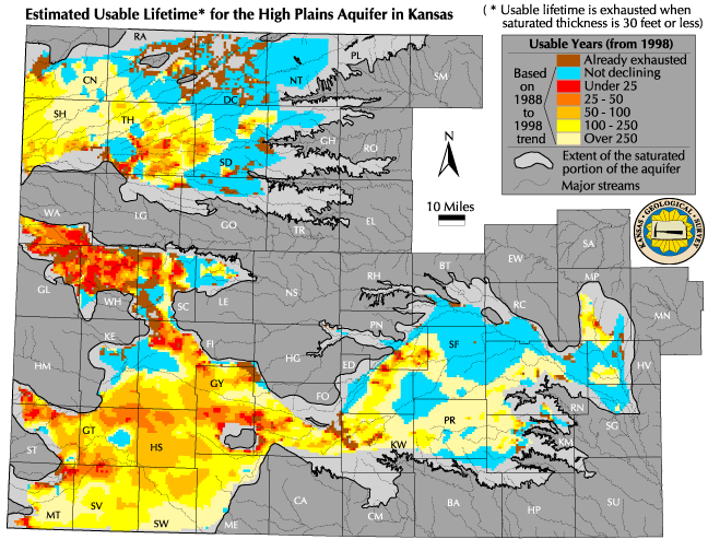
![]() Map of estimated usable lifetime (1988-98 trend
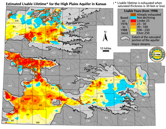
Map of estimated usable lifetime (1988-98 trend ![]() Map of estimated usable lifetime (1978-88 trend)
Map of estimated usable lifetime (1978-88 trend)
Discussion: Both maps presented here use the average of the 1997, 1998, and 1999 saturated thickness estimates to determine areas in which the resource has already been exhausted (saturated thickness 30' or less), and as a starting point for determining the number of years remaining in the aquifer's usable lifetime. The difference between the two maps comes from their use of water-level data from different time periods to calculate the trend in water level change -- the first map presented uses the difference between the average water-levels from 1987-1989 and from 1997-1999 to establish a linear trend in water-level change based on a ten-year period. The second map is based on water-level trends between 1977-1979 and 1987-1989. The water-level trends are then applied to the averaged 1997-1999 saturated thickness values to project the number of years it will take for the saturated thickness to reach the 30' mark These maps should be used in combination with the maps of current saturated thickness, water in storage, and maximum authorized use, because the estimated usable lifetime calculated here will not exactly reflect the actual, on-the-ground situation for several reasons.
One fundamental issue is the use of the 30' value as an indicator of resource exhaustion (see drawdown and pumping). This would ultimately be a policy decision supported rather than detemined by technical analysis, and the 30' example used here is only an approximation for the purposes of illustration. Another fundamental issue is the inherent uncertainty in predicting the future of the climate (see Recharge section) -- the results of using two different historically-supported water-level trend scenarios illustrate this. A prudent approach might be to use an intermediate value for planning purposes, while recognizing the potential for significant variation. Other factors that could significantly change the predictions include changes in groundwater or land use, and use of one of the many possible alternative methods for performing the calculations. For instance, water-level trends could be calculated for periods longer than ten years, or could be calculated as a 'best fit' for the entire water-level measurement history of each well instead of using three-year averages that are a decade apart. Most importantly, a very large area of the aquifer already has less than 100' of saturated thickness, and has had this range of values for some time. The value of 30' has been identified by KWO, KDA-DWR, and KGS as a conservatively low estimate of the saturated thickness required for effective depletion. However, many of the more thinly saturated areas may already be experiencing reduced levels of pumping because of reduced Accessibility and Availability of the water, and some management units have used a value of 50' of saturated thickness as a criterion for deciding if water can be available for appropriation. These factors may contribute to long estimated depletion times in some thinly saturated areas, without reflecting the important fact that the resource is already significantly depleted. The full range of possibilities for making predictions about aquifer response has yet to be explored, and the maps presented here are but two examples, selected to illustrate the differences when only one variable (the time period used to calculate the linear water-level trend) is altered. While the maps are fairly similar in appearance, the actual differences in annual water-level trend estimates at one-mile section centers varied by almost five feet in some sections. Given that the maps use 25 years as the first class break for data display, the difference in annual trend (of nearly 5' per year or 125' over a twenty-five year period) can easily result in large local variations in predictions about the future of the resource.
The short times to depletion shown for much of GMD1 and for parts of northern GMD3 and southern GMD4 reflect a combination of low to moderate predevelopment Water in Storage and Saturated Thickness and relatively high levels of Authorized Use. Water rights and land use in these areas have been relatively stable over the past two decades, but this is not the case everywhere. For example, some areas in the Cimarron River basin in extreme southwestern Kansas have undergone recent development during the 1990s, so the rate of decline has been increasing rather than staying relatively constant. In this case, an estimate based on an assumed straight-line projection of the change over the whole decade will underestimate the actual rate of depletion, even if wet climatic conditions persist.
Adoption of different assumed values for effective depletion and projected withdrawal will change not only the estimate, but also the nature of the ultimate consequences. For example, a transition to high-efficiency, low-volume uses such as drip irrigation could substantially extend the life of the resource, but might ultimately result in nearly complete elimination of saturated thickness in some areas, with the resulting loss of water supplies available for municipal and domestic use, stock watering, etc. (see discussion and illustration in the appendix on drawdown and pumping). It is also important to note that these estimates do not consider the increased costs of pumping, well replacement, etc., as water tables drop.
Sources and methods: The estimated usable lifetime is derived from determinations of the saturated thickness (see atlas sections and methods appendices for discussion of methods). The estimated bedrock elevation plus an additional saturated thickness of 30' is used to represent the target condition of effective depletion for high-volume pumping. The difference between the water table elevations (which is identical to the change in saturated thickness) determined for averaged 1998 (1997-1999) and 1988 (1987-1989) conditions is used to calculate the average annual change in saturated thickness for each legal section (approximately one square mile) for which data are available:
Sections where the water-level trend calculations indicated rising water-levels were grouped in the map classification labled 'not declining'. Sections where the saturated thickness values averaged for 1997-1999 were already 30' or less were grouped in the map classification labeled 'already exhausted'. The uncolored portions of the aquifer were areas where water-level data were inadequate to construct a satisfactory estimate; since most of these areas are near the fringe of the aquifer and have relatively low water right development, it is likely that there is a high incidence of thinly saturated regions in these 'no data' areas. For the remaining sections (where the aquifer had more than 30' of saturated thickness and the water-level trend estimates indicated declining water-levels), the values are mapped as ranges of years, which reflects both the spatial variability of the resource and its use, and the uncertainty in the estimates. The use of values for legal sections is discussed under qualifications below.
Qualifications: These estimates are made for general assessment and planning purposes only, and should not be interpreted as having any regulatory status, or used in place of more detailed, officially adopted maps used by water management agencies. Values are calculated and plotted at the scale of legal sections (square miles), but the flow of groundwater (see appendix on storage and flow) will tend to smooth out the short-range variations shown on the map. Spatial variations in aquifer characteristics and water use make interpretation at larger scales, such as the township, more appropriate (for example, see Maximum Authorized Use). The estimates are not meant to be a firm definition or prediction of aquifer depletion, but rather an illustrative projection -- a picture of the range of probable results if past use and climate patterns are extended into the future. The discussion section above addresses some of the implications of these assumptions in more detail.
See also: Current Saturated Thickness, Water in Storage, Maximum Authorized Use, Accessibility and Availability.
Next section: Changes in Use Necessary for Sustainability
Back to Directory
Funded (in part) by the Kansas Water Plan Fund