J. A. Schloss, R. W. Buddemeier
Boldface items are linked to other sections; italic items are linked to glossary definitions
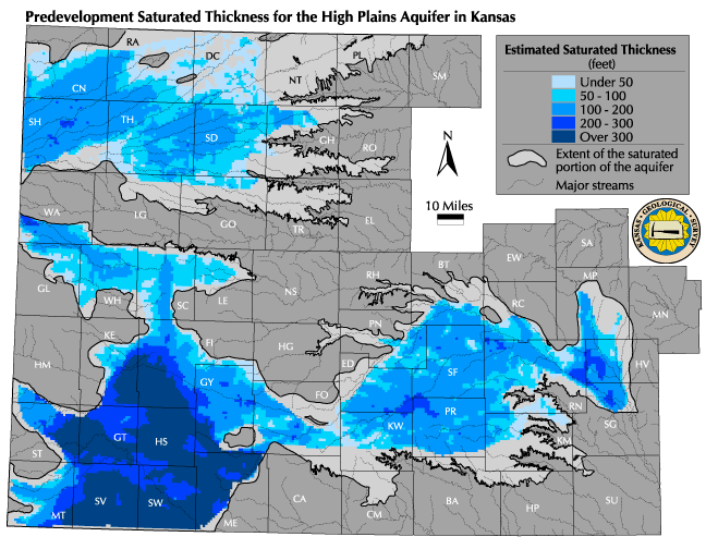
Saturated thickness is the vertical thickness of the hydrogeologically defined aquifer unit in which the pore spaces are filled (saturated) with water. The predevelopment value is the estimated saturated thickness before the withdrawal of significant amounts of groundwater, and is taken as the starting point against which the amount and rate of any depletion is measured. It is commonly used as an indicator of available resources in setting management and use policies and regulations.
Relevance to understanding water resources: Saturated thickness is a key link between the measurements that can be readily made (of changes in water-table elevation) and the changes in resources available for use. The saturated thickness times the surface area times the specific yield is equal to the volume of potentially extractable water beneath a given area of land surface -- for example, if the saturated thickness below an acre of ground is 100 feet and has a specific yield of 10%, the potential extractable water is 10 acre-feet (AF). Specific yield is difficult to determine with accuracy and precision, but for a given volume of the aquifer it is constant over time, and it commonly varies over space by less than a factor of about two. For these reasons, it is convenient and common to use the saturated thickness as an approximate indicator of the amount of water available and its rate of change.
![]() Map of Predevelopment Saturated Thickness
Map of Predevelopment Saturated Thickness
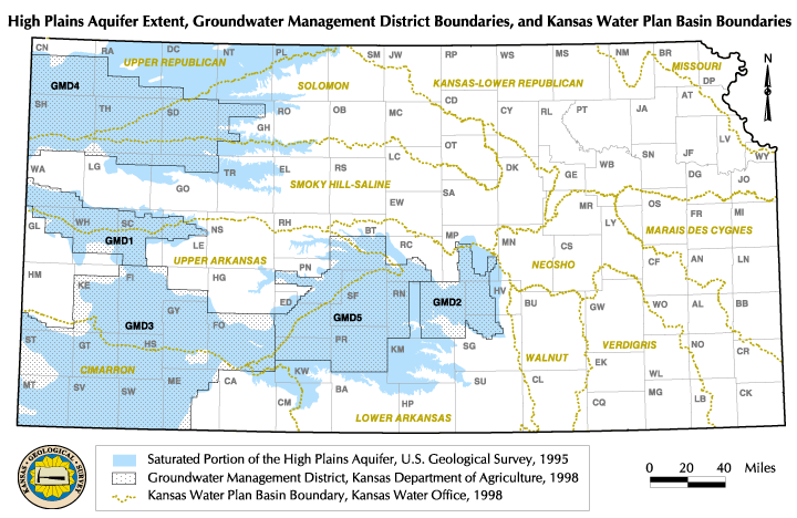
Discussion: The map shows estimates of predevelopment saturated thickness for the parts of the High Plains aquifer for which adequate data are available. For comparison with the major hydrologic and administrative units (basins, Groundwater Management Districts) of the state, see the introductory map. The 'blank' areas of the aquifer (inside the High Plains Aquifer extent but not coded for saturated thickness) do not have an adequate number of data points and/or boundary definition to permit useful estimates by the techniques used. In western Kansas these are mostly fringe areas, and are likely to be in the lowest (0-50 feet) category -- an amount of saturated thickness not generally considered reliably useful for sustained high-volume pumping. This is reflected in the amount of water currently appropriated to water rights (see Current Maximum Authorized Use).
The original groundwater resources were unevenly distributed, in ways primarily controlled by bedrock topography and patterns of recharge and discharge. In southwestern Kansas, for example, the bedrock is deep beneath the surface and the thickness of the aquifer is the greatest. In terms of the Availability and Accessibility of the resource for human use, this uneven distribution of the resource does not always provide a good match with soil types, surface topography, or other features of the aboveground landscape that affect human water use and demand.
The distribution of the resource also suggests ways in which management-oriented subunits might be defined. In fringe areas of the aquifer, the saturated thickness is near or below the value needed to support high-volume pumping on a sustained basis; in the central groundwater 'basins' the volume of water available allows managing over a longer time horizon; while intermediate regions (e.g., 50-100 feet of saturated thickness) represent areas that can sustain systematic groundwater usage in excess of the natural recharge for only a relatively short period of time.
Data sources and methods: Saturated thickness estimates are based on point measurements of the bedrock elevation and of the water table surface. Many locations where depth to bedrock has been recorded do not have water-level measurements and vice-versa, and many of the wells that were measured prior to the development of the aquifer (generally 1940 - 1950) are no longer accessible. Techniques have been employed to make use of as much of the available information on depth to bedrock and predevelopment water level as possible.
Qualifications (uncertainties, data needs, etc.): As with all maps in this atlas, this presentation is designed to provide general information only and is not intended to be used for regulatory or management purposes, or to replace or invalidate maps that have been adopted for those purposes. Major limitations restrict the precision with which we can define the predevelopment water table. Relatively few early measurements are available in many areas, and the available data represent a composite of measurements taken in different years and different seasons. This, in combination with the other factors shown in the appendix on saturated thickness, means that there is a rather substantial uncertainty (certainly of feet, perhaps tens of feet in some locations) in the absolute value of the predevelopment saturated thickness. However, measured changes in saturated thickness over more recent time periods are not affected by errors in the predevelopment estimate. Townships and sections are typically used for management applications, but these do not necessarily match either the natural scales or the distribution of groundwater. The appendix on saturated thickness illustrates in cross-sectional view some of the issues and uncertainties involved in determining saturated thickness and related variables, and the map provides an image of the spatial distribution of the resource at a scale large enough to be unaffected by the known levels of uncertainty.
See also: Water In Storage, Current Saturated Thickness, Estimated Usable Lifetime
Next section: Current Saturated Thickness
Back to Directory
Funded (in part) by the Kansas Water Plan Fund