B. B. Wilson, J. A. Schloss, R. W. Buddemeier
Boldface links are to other atlas sections; italic items are linked to glossary definitions
Definition: Authorized use is the amount of water that is authorized to be pumped in a given year under water right allocations. Each water right permit or certificate allows the water right holder a set quantity of water that can be used each calendar year. The quantity of water assigned to a water right depends on factors such as the location of the water right and whether the water right overlaps other senior water rights in either the point of water diversion or place of use (e.g., an irrigation field boundary).
Relevance to understanding water resources: The amount of water that can legally be pumped from a given area is a key component in identifying areas of the High Plains aquifer that may be overdeveloped in terms of water rights. If the amount of consumptive water use authorized by groundwater rights is greater than the amount of water that is naturally recharged to the aquifer system, then the potential exists for aquifer resources to become stressed and decline over time. Authorized quantity is one of the primary components of the Kansas Department of Agriculture's Division of Water Resources' (KDA-DWR) calculation of the local aquifer yield that is used as part of the review process to accept or deny water right applications.
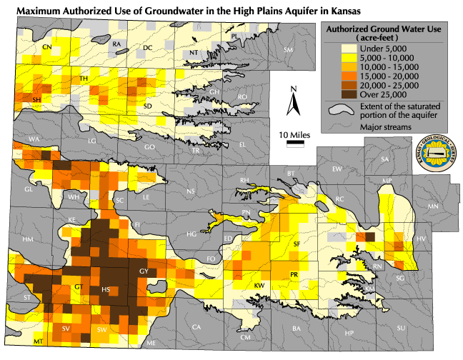
![]() Map of Current Maximum Authorized Use
Map of Current Maximum Authorized Use
Discussion: The Current Maximum Authorized Use map shows how much water could be pumped each year. This is not the amount of water actually pumped (see sections on Water Usage and Percent of Authorized Quantity Used), but rather how much could be pumped if all water right allocations pumped their full authorized quantity. Measured use in an area is typically somewhat less than the total use authorized for that area, due to climate, economic factors, and farm management practices. The map of maximum authorized use shows the amount of water, in acre-feet per township (approximately 36 square miles), that can legally be pumped from the groundwater underlying that township in any given year. The distribution of water rights shows high concentrations of authorized use in areas of water availability, but other factors influence the distribution as well. The distribution of rights may reflect past as well as present patterns of water use, and the existence of soils and terrain suitable for irrigation has also influenced the distribution.
Because the amount of water that is authorized to be pumped under a water right may be changed as the water right progresses through the KDA-DWR's regulation and appropriation process, this map represents water right conditions as of the date of map. When a person or organization initially applies for a permit to appropriate water, the applicant lists how much water would be used based on the intended use and the amounts permitted at the proposed location of the well. Assuming the water right application passes other rules and regulations, such as safe yield and well spacing, a set period of time is given to the water right applicant to develop or perfect the water right permit. This is the certifcation period (also referred to as the "perfection period") and generally lasts 5 years depending on the use made of water. After that time, the amount of water actually used during the perfection period, in addition to other factors, will determine how much water will be authorized to be used when the water right is finally certified. Generally, the authorized amount under the certified water right is less than the amount applied for. Once certified, the authorized quantity will not change unless there are other adjustments to the water right (for example, changes in the point of water diversion or place of use).
Sources and methods: The authorized quantity values were obtained from the KDA-DWR's Water Rights Information Systems database and represents water right conditions as of late 1999 for Vested and Appropriated groundwater rights. In the database, the authorized quantity is assigned to water rights in one of three different ways: by the water right itself; by the use made of the water; or by the point of water diversion. Several calculations were made to summarize these different types of entries into the total authorized quantity by Public Land Survey System (PLSS) township. The total amount of water authorized for each right that was stored by either water right or water use was divided by the number of points of diversion permitted under the water right. For every unique PLSS township, the pro-rated quantity for the points of diversion within the township was then combined with the quantities for the same township from water rights stored by point of diversion. This total is the maximum authorized quantity for the township.
Qualifications: Water rights in the State of Kansas can be extremely complex and dynamic. Due to restrictions, limitations, and/or special water right conditions that exist for some water rights in Kansas, in combination with the potential for water rights to cross any spatial subunit (such as a PLSS section or township), it is impossible to precisely summarize the authorized quantity by any spatial subunits in a way that is completely accurate for both the total authorized use and the individual water rights. The steps outlined in the Data Sources and Methods section of this report adequately represent the vast majority of the water rights in Kansas at the time of the calculation. This procedure provides a reasonably accurate estimate of the maximum possible total pumping at relatively large spatial scales (e.g., township size or larger). Domestic wells and other small withdrawals not subject to the appropriation process add a very small amount to the total withdrawal, but this volume is unlikely to be significant relative to either authorized or actual permitted use.
See also: Current Saturated Thickness, Water in Storage, Estimated Usable Lifetime, Changes in use Necessary for Sustainability.
Next section: Water Usage
Back to Directory
Funded (in part) by the Kansas Water Plan Fund