M. A. Sophocleous, J. A. Schloss
Boldface items are linked to other sections; italic items are linked to glossary definitions
Definitions: Groundwater recharge is the replenishment of an aquifer with water from the land surface. It is usually expressed as an average rate of inches of water per year, similar to precipitation. Thus, the volume of recharge is the rate times the land area under consideration times the time period, and is usually expressed as acre-feet per year. In addition to precipitation, other sources of recharge to an aquifer are stream and lake or pond seepage, irrigation return flow (both from canals and fields), interaquifer flows, and urban recharge (from water mains, septic tanks, sewers, drainage ditches). Agricultural scientists use the term deep drainage to denote the downward flux of water below the plant root zone. Often this deep drainage flux is equated to recharge (that is, water reaching the water table). This will be true if no other losses of water occur below the root zone, such as subsurface lateral flows due to the make-up and orientation of geologic strata, absorption by sediments above the water table, and other causes, which may prevent the deep drainage from reaching the water table, especially when the water table is deep. Therefore, the deep drainage flux measured just beneath the root zone should be considered potential recharge. When the sole source of such potential recharge is precipitation, it is usually called potential natural recharge. Such potential natural recharge does not consider the other sources of recharge mentioned previously. In contrast to natural recharge (which results from natural causes), artificial recharge is the use of water to artificially replenish the water supply in an aquifer, as is done in the Equus Beds aquifer with the Wichita recharge project.
Relevance to understanding water resources: If withdrawals exceed recharge, the water table in the aquifer will most probably decline. If this condition continues long enough, parts of the aquifer may be dewatered and become unusable as a source of water. In Kansas, the Division of Water Resources of the Kansas Department of Agriculture (KDA-DWR) uses existing estimates of precipitation-based annual recharge to determine "safe yield" quantities for different aquifers across the state. The quantity of recharge to an aquifer has been considered equivalent to the "safe yield" or quantity of water that could be removed from an aquifer on a sustainable basis. We now understand that the "sustainable yield" of an aquifer is almost always appreciably less than recharge. This is because sustainable yield must also allow for adequate provision of water to sustain streams, springs, wetlands, and groundwater dependent ecosystems (Sophocleous, 1997; 1998; 2000). Nevertheless, a sustainable yield figure is derived from a recharge determination, and any sustainable yield study will usually involve the determination of recharge as a first necessary step.
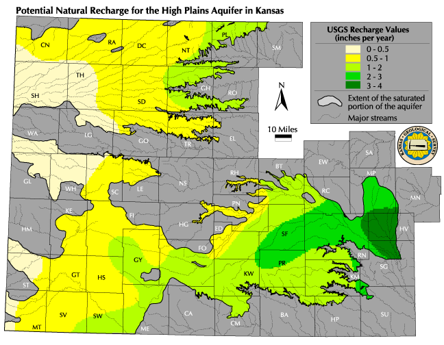
![]() Map of potential natural recharge values
Map of potential natural recharge values
Discussion: The potential natural recharge map shows the annual amount of precipitation-based recharge in inches for western and central Kansas as estimated in the US Geological Survey (USGS) Water Resources Investigations Report 87-4230 (Hansen, 1991). The Kansas study used a soil-moisture accounting model developed as part of the USGS Central Midwest Regional Aquifer System Analysis (CMRASA; Dugan and Peckenpaugh, 1985) to estimate the rate of recharge in western and parts of central Kansas. The results were combined with additional results from the CMRASA study to make a generalized map showing mean annual rate of recharge in Kansas. As can be inferred from this map, the distribution of annual recharge follows a similar pattern to that of annual precipitation across the state, that is, it progressively decreases as one moves westward across the state. The climatic conditions are such that not only is precipitation low in western Kansas, but most of it is lost to evaporation from the soil surface and transpiration from plants. More than 99% of the rainfall is returned to the atmosphere in 14 southwestern Kansas counties, and more than 95% is returned throughout the western half of the state, thus resulting in meager recharge to the High Plains aquifer in that region. (In eastern Kansas an average of 85% of the rainfall is returned to the atmosphere.) Thus, climatic conditions constitute a primary control on recharge, although vegetation and soils also influence recharge.
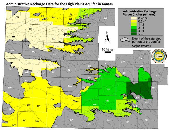
![]() Map of administrative recharge values
Map of administrative recharge values
The administrative recharge map shows the amount of annual recharge, in inches, that is available for appropriation based on rules and regulations adopted by KDA-DWR. The map was created by interpolating values between the contours of the potential natural recharge map, creating a digital gridded map, and overlaying on it the areas of special administrative recharge, such as the boundaries of the five Groundwater Management Districts (GMDs) and the KDA-DWR Unit Basins in south-central Kansas. In these areas, recharge standards have been set through some approach other than the use of the USGS map or similar data.
Data Sources and Methods: The USGS study (Hansen, 1991) employed a soil-moisture accounting model to estimate recharge based on soil, vegetation, and climate data (precipitation, temperature, and percent possible sunshine data). However, the basic data used in the USGS model, as well as the assumptions and limitations of that model application, are not presented in that report. Details on the methodology employed are also not reported, but the recharge model used was the same soil-moisture accounting model as the one used in the USGS CMRASA study to estimate the mean annual recharge in much of eastern and central Kansas. The CMRASA study is documented in the USGS Water Resources Investigations Report 85-4236 (Dugan and Peckenpaugh, 1985).
Qualifications: Of all the factors in the evaluation of groundwater resources, the rate of recharge is one of the most difficult to derive with confidence. Estimates of recharge are normally subject to large uncertainties and spatial and temporal variability. For example, during the floods of 1973 and 1993, substantial areas in the Big Bend GMD 5 in south-central Kansas went from a net decline to a net increase in the water table elevation as a result of these relatively rare extreme flood events.
The CMRASA recharge estimation model application (Dugan and Peckenpaugh, 1985) covered an area of approximately 275,000 square miles in Nebraska, Colorado, Kansas, Oklahoma, and Texas, and employed monthly climatic data for a 30-year period (1951-1980) to derive mean potential recharge estimates. Because of the simplifications made in the model, the USGS recharge estimates may be considered representative at the county level. As mentioned earlier, no stream seepage, irrigation return flow, or other sources of recharge were considered in this USGS analysis. In view of the above, caution should be exercised in attempting to apply the results to specific areas. Furthermore, these recharge estimates were not calibrated or statistically evaluated with empirically derived hydrologic data or groundwater flow model simulations. Such tests are necessary for more detailed applications. The recharge estimates used by KDA-DWR are based on the previously mentioned and other USGS reports, as well as on Kansas Geological Survey studies. Actual field studies to determine recharge are lacking in many parts of Kansas, especially in western Kansas.
References:
Dugan, J. T., and Peckenpaugh, J. M., 1985, Effects of climate, vegetation, and soils on consumptive water use and ground-water recharge to the Central Midwest regional aquifer system, midcontinent United States: U.S. Geological Survey, Water Resources Investigations Report 85-4236, 78 p.
Hansen, C. V., 1991, Estimates of freshwater storage and potential natural recharge for principal aquifers in Kansas: U.S. Geological Survey, Water Resources Investigations Report 87-4230, 100 p.
Sophocleous, M. A., 1997, Managing water-resources systems?Why "safe yield" is not sustainable: Ground Water, v. 35, no. 4, p. 561
________, 1998, Perspectives on sustainable development of water resources in Kansas: Kansas Geological Survey, Bulletin 239, 239 p.
________, 2000, From safe yield to sustainable development of water
resources?The Kansas experience: Journal of Hydrology, v. 235, no. 1-2,
p. 27-43
Next section: Current Maximum Authorized Use
Back to Directory
Funded (in part) by the Kansas Water Plan Fund