Landslide Hazards of the Kansas City Metropolitan Area
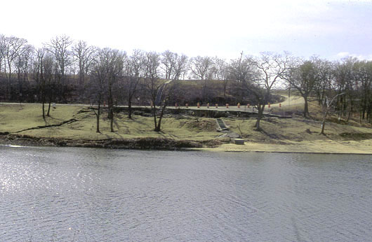
Picture is of a landslide (earth flow) that occurred along the margin of Lone Star Lake in Douglas County, Kansas. Lone Star Lake is located about 18.5 km (11.5 miles) southwest of downtown Lawrence. The landslide occurred in 1998 while the lake level was low due to spillway repairs. The landslide remediation consisted of removing part of the landslide mass, creating a reinforced earth wall to support the scarp area, and improving surface and subsurface drainage. The landslide occurs in the upper Lawrence Formation, which consists of a paleosol and marine shales.
Tectonic and Neotectonics of Kansas and the Midcontinent
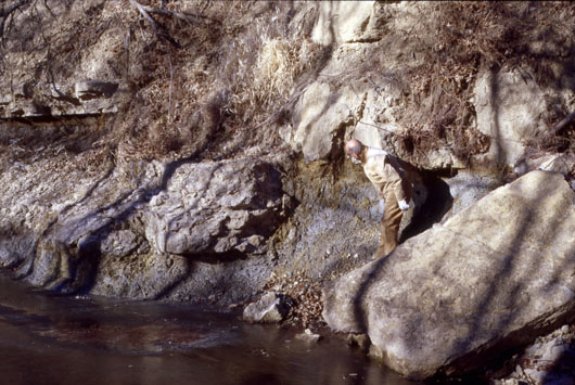
Picture is of a small vertical fault with about 1 meter of vertical displacement. This surface fault is a segment of the Humboldt Fault Zone, which stretches from southern Nebraska across eastern Kansas to northern Oklahoma. The largest earthquake in Kansas and many small earthquakes (M < 3.0) have occurred along segments of the Humboldt Fault Zone. This outcrop is located on private property about 15.3 km (9.5 miles) north-northeast of Wamego, Kansas near the valley of Vermillion Creek. Contact land owner or owner’s representative before visiting this feature
Geologic Hazards in Kansas: Sinkholes
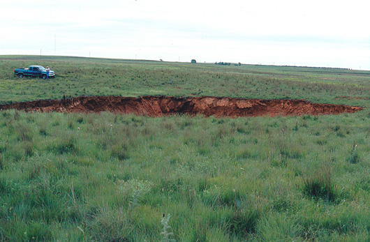
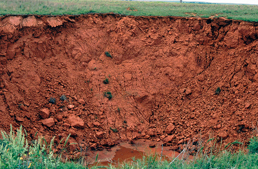
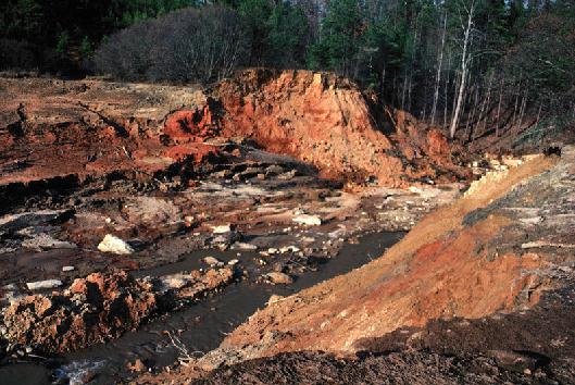
This sinkhole occurred in 2000 southwest of Ashland, Kansas. The opening was about 30.5 m (100 ft.) in diameter and the depth was estimated at 15 m (50 ft.). Permian age red beds (red shales and siltstone) are exposed in the wall of the sinkhole. Permian rocks in this part of Kansas have gypsum beds that can be dissolved by ground water forming caves. This sinkhole is still visible on the 2002 orthophotograph of Kansas available on from DASC. The sinkhole is located on private land. Contact land owner or owner's representative before visiting this feature.
Geologic Hazards in Kansas: Earth Fissures
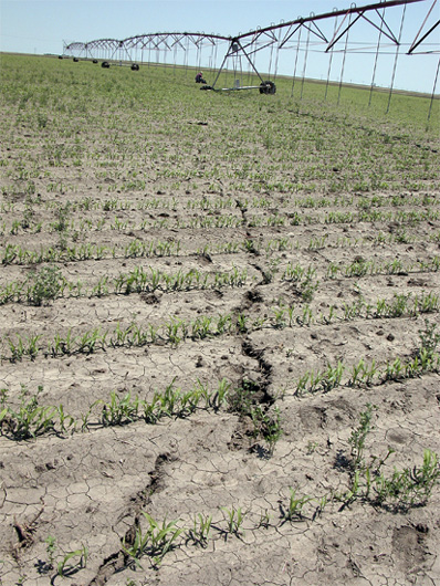
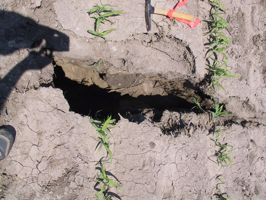
This earth fissure opened in 2004 in Gove County, Kansas (east of Oakley). An earth fissure is a recent fracture in the soil and/or rock that breaks the ground surface. Many causes exist for earth fissures, and the cause of this earth fissure was not determined. This fissure was more that 91m (300 ft) long and about 1.4 m (4.5 ft) deep. In most places its aperture was a few centimeters; however, in several places the aperture widens to 0.5 m (1.5 ft). The upper photo shows the earth fissure extending to where the individual is sitting on the other side of the center-pivot irrigation system. One wheel of the center-pivot irrigation system has fallen into the earth fissure. The lower picture shows one of the larger openings along the earth fissure. This feature is on private land. Contact land owner or owner's representative before visiting this feature.
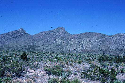
Photograph is of the Pipeline Complex in the northern Franklin Mountains. This area has been interpreted as being either a large landslide or complex normal faulting. A low-angle normal fault can be seen extending from just left of the central peak toward the right side of the image. A oblique-slip or strike-slip fault runs along the stream bed at the base of the Complex. Fracture systems associated with these faults may play a role in ground-water migration. The photograph was taken in Hitt Canyon looking north.
Slope Stability West Texas and Southern New Mexico
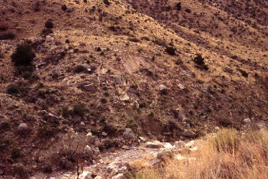
This earth slide is located in Dry Canyon east of Alamogordo, New Mexico The scarp is about 7 feet high, and well developed tension fractures are observed up slope from the scarp. What makes this earth slide interesting is that this portion of Dry Canyon has a semi-arid to arid climate. The causes of this earth slide are under investigation. The photograph was taken in 1994.
Rock Fracture Project Southern Appalachians
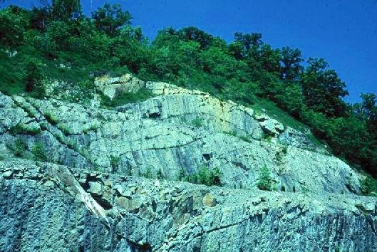
This photograph is of the south outcrop at Bays Mountain, Kingsport, Tennessee. The rocks exposed are part of the Saltville Thrust Sheet. Folds, a syncline on the right and an anticline to the left, are clearly visible in the photograph. Additionally, numerous veins, faults and pressure solution surfaces are also exposed at this location. My dissertation mapping classified the mesoscopic-scale structures at two locations in Tennessee. The bedrock unit is the Ordovician Sevier Shale, which consists of alternating layers of thinly bedded siltstone and shale.
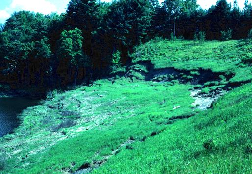
This earth flow located along the eastern shore of North Springfield Reservoir occurred in 1984. This and many other landslides were triggered by heavy rainfall and melting of a thick snowpack. The upper layer of the landslide in the photograph moved as an intact block over layer of saturated soil that behaved like a slurry. Further information on this landslide can be found in Ohlmacher and Baskerville (1991).
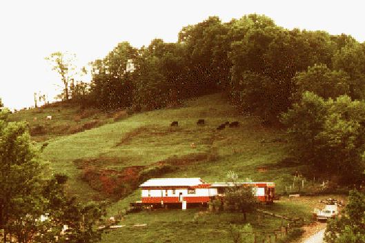
This photograph is of a recent earth flow in central West Virginia. The local bedrock is the Permian Dunkard Group, which consists of cyclothems containing layers of red mudstone (shale). Red mudstones slake to form clayey soils prone to landsliding. The photograph was taken in 1979.
Other U. S. Geological Survey Projects
Kelly Barnes Dam failed November 6, 1977. The dam was located near the town of Toccoa, Georgia. The photograph is of the remains of the dam taken looking downstream from the right abutment. The dam was a homogeneous earth fill dam about 44 feet high, about 300 feet wide along the crest and about 90 feet wide along the base. The photograph was taken about 10 days after the failure.
Kansas Geological Survey
Updated Jan. 28, 2005
Comments to webadmin@kgs.ku.edu
URL=http://www.kgs.ku.edu/General/Personnel/nop/ohlmacpho.html