Associate Scientist, Geologic Investigations, Kansas Geological Survey
Engineering, Environmental & Structural Geology and Geomechanics
| |
Dr. Ohlmacher is no longer with the Survey. |
Address Information
|
|
Assistant Professor, Department of Geological Sciences, University of Texas
at El Paso, El Paso, Texas, 1993 to 1997.
Senior Lecturer, Department of Chemistry and Geology, Mary Washington College,
Fredericksburg, Virginia, 1991 to 1993.
Teaching and Research Assistant, Department of Earth and Atmospheric Sciences,
Purdue University, West Lafayette, Indiana, 1983 to 1991
Physical Science Technician (Geology), U.S. Geological Survey, Reston,
Virginia, 1975 to 1989
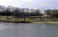
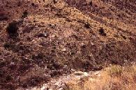
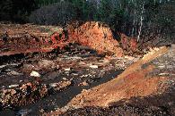
| Geologic Hazards--Landslide Hazards of the Kansas City Metropolitan Area: | |
|
Click on image to see a larger version with an explanation. |
The growth of the Kansas City metropolitan area in Kansas has encountered geologic hazards. Landslides, mine subsidence, flooding, and expansive soil problems have occurred in Atchison, Douglas, Johnson, Leavenworth, and Wyandotte counties. In addition, alluvial sediments may be subject to liquefaction given the proper circumstances. As development continues in the Missouri River Corridor more engineering problems can be expected. The Landslide Hazards of the Kansas City Metropolitan Area Program is planning to collect, evaluate, and distribute geologic and soil information related to the landslide problems along the Missouri and Kansas Rivers. At this time landslide inventory and hazard maps have been developed for the cities of Atchison, Leavenworth, Easton, and Potter. |
|
Ohlmacher, G. C., 2004, Landslide inventory map of the Potter and Oak Mills 7.5 minute quadrangles Jefferson, Leavenworth, and Atchison Counties, Kansas: Kansas Geological Survey Map M-113A, 1:36,000 scale Ohlmacher, G. C. and Davis, J. C., 2004, Landslide-hazard map of the Potter and Oak Mills 7.5 minute quadrangles Jefferson, Leavenworth, and Atchison Counties, Kansas: Kansas Geological Survey Map M-113B, 1:36,000 scale Ohlmacher, G. C., 2004, Landslide inventory map of the Easton SW and Easton 7.5 minute quadrangles Jefferson and Leavenworth Counties, Kansas: Kansas Geological Survey Map M-115A, 1:36,000 scale Ohlmacher, G. C. and Davis, J. C., 2004, Landslide-hazard map of the Easton SW and Easton 7.5 minute quadrangles Jefferson and Leavenworth Counties, Kansas: Kansas Geological Survey Map M-115B, 1:36,000 scale Ohlmacher, G. C. and Davis, J. C., 2003, Using multiple logistic regression and GIS technology to predict landslide hazard in northeast Kansas, USA: Engineering Geology v. 69, 331-343. Ohlmacher, G. C., 2003, Landslide inventory map of the Leavenworth, Weston, and Platte City 7.5 minute quadrangles Leavenworth and Atchison Counties, Kansas: Kansas Geological Survey Map M-109A, 1:36,000 scale Ohlmacher, G. C. and Davis, J. C., 2003, Landslide-hazard map of the Leavenworth, Weston, and Platte City 7.5 minute quadrangles Leavenworth and Atchison Counties, Kansas: Kansas Geological Survey Map M-109B, 1:36,000 scale Davis, J. C., Chung, C. J., and Ohlmacher, G. C., 2003, Two models for evaluating landslide hazards: International Association of Mathematical Geology, 2003 Conference, September 7-12, 2003, Portsmouth, England, CD-ROM, 7 p. Ohlmacher, G. C. and Davis, J. C., 2002, Landslide-hazard map of the Atchison West and East 7.5-minute quadrangles, Atchison County, Kansas: Kansas Geological Survey, Map M 89 B, 1 map Davis, J. C., and Ohlmacher, G. C., 2002, Landslide hazard prediction using generalized logistic regression: 8th Annual Conference of the International Association for Mathematical Geology, Berlin, Germany, 501-506 Ohlmacher, G. C., 2000, Landslide inventory map of the Atchison West and East 7.5 minute quadrangles, Atchison County, Kansas: Kansas Geological Survey, Map M 89 A, 1 map Ohlmacher, G. C., 2000, The relationship between geology and landslide hazards of Atchison, Kansas, and vicinity; in, Current Research in Earth Sciences: Kansas Geological Survey, Bulletin 244, pt.3, 16 p. |
|
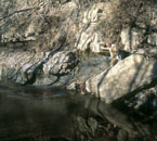
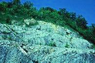
| Tectonic and Neotectonics of Kansas and the Midcontinent: | |
|
Click on image to see a larger version with an explanation. |
People driving across Kansas view the area as a structural geologic wasteland with mostly horizontal rock layers (strata). However, folds and faults were recognized and mapped in Kansas over 100 years ago. Less is known about the potential earthquake hazard of the state of Kansas. Historic accounts provide evidence for 27 earthquakes that occurred prior to 1977, and a seismic network was operated from 1977 to 1989. Since 1989, earthquake data has come from the U.S. Geological Survey seismic network. Thus the seismic hazard of Kansas is based on a limited data set. The purpose of this research project is to better define the seismic hazard of Kansas by (1) an improved understanding of the mechanics of surface structural features (folds, faults, and joints) and (2) searching for evidence of past earthquake events primarily liquefaction. |
|
Ohlmacher, G. C., and Berendsen, P., in press, Kinematics, mechanics, and potential earthquake hazards for faults in Pottawatomie County, Kansas, USA: Tectonophysics (available on-line) |
|
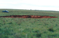
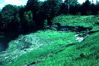
| Geologic Hazards in Kansas: | |
|
Sinkholes:
|
Earth Fissures: 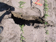
|
| Click on image to see a larger version with an explanation. | |
Surface and Ground Water Interaction along the Rio Grande:
This project studied the fluctuations in chloride and ion concentrations in the Rio Grande near El Paso, Texas. The project cataloged both seasonal and climatic variations in the ion concentration of the river. Ion concentrations were higher during times of low flow both winter (non-irrigation flow) and drought. The project also modeled the interaction of the Rio Grande and shallow aquifers in the Mesilla Bolson. Additional information can be found on Dr. John Walton’s web site: http://rorykate.ce.utep.edu/surfgw/surfacegroundwater.htm. If that link fails, then try the Department of Civil Engineering, University of Texas at El Paso web site.
Walton, J., Ohlmacher, G. C., Utz, D., and Kutianawala, M., 1999, Response of the Rio Grande and shallow ground water in the Mesilla Bolson to irrigation, climate stress, and pumping: Environmental and Engineering Geoscience, 5, 41-50
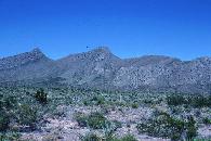
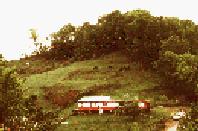
| Mountain Front Recharge: | |
|
Click on image to see a larger version with an explanation. |
The availability of fresh water controls the amount of development in arid regions. El Paso, Texas, obtains most of its water from aquifers in two intermontane basins (Hueco and Mesilla Bolsons). These basins receive recharge from three sources: leakage from the Rio Grande and irrigation canals, water from the surrounding mountains (aka mountain front recharge), and direct infiltration of precipitation. This project is examining surficial deposits and fracture systems in bedrock in order to evaluate the distribution and quantity of mountain front recharge within the Franklin and Sacramento Mountains, Texas and New Mexico. |
|
Ohlmacher, G. C., 1999, Structural domains and their potential impact on recharge to intermontane-basin aquifers: Environmental and Engineering Geoscience, 5, 61-71 Ohlmacher, G. C., 1996, A preliminary note on the fractures and groundwater recharge, Franklin Mountains, west Texas: in Clark, K. F. and Hoffer, J. M. (eds.), A Geologic Traverse Through Parts of Northwestern Mexico: Guidebook for the 1996 Field Conference, Southwest Section American Association of Petroleum Geologist, p. 99-103. |
|
| Slope Stability West Texas and Southern New Mexico: | |
|
Click on image to see a larger version with an explanation. |
This project is examining the landslides of west Texas and southern New Mexico. Two investigations are ongoing. One involves the distribution and causes of debris flows and earth slides near High Rolls, NM in the Sacramento Mountains. This mountain range produces enough orographic precipitation to trigger landslides. The second is examining the mechanics of large rock slides. Approximately 15 rock slides are recognized in the Franklin Mountains. These rock slides are thought to be Plio-Pleistocene in age when this region may have had a more humid climate. Plans exist to examine debris flows in the Franklin and Organ Mountains. |
| Rock Fracture Project Southern Appalachians: | |
|
Click on image to see a larger version with an explanation. |
My dissertation research involved investigating the sequence of formation of mesoscopic-scale structures including veins, faults, and pressure solution surfaces, the mechanics of formation of these mesoscopic-scale structures, the effects of both remote state of stress and fault friction on the local state of stress near thrust faults, the role of pore-fluid pressure during thrust faulting, and the potential for fluid migration through interconnected fractures at two locations in the Appalachian fold and thrust belt of northeastern Tennessee. |
|
Ohlmacher, G. C., and Aydin, A., 1997, Mechanics of vein, fault, and solution surface formation in the Appalachian Valley and Ridge, northeastern Tennessee, U.S.A.: Implications for fault friction, state of stress, and fluid pressure: Journal of Structural Geology, v. 19, p. 927-944. Ohlmacher, G. C., and Aydin, A., 1995, Progressive deformation and fracture patterns during foreland thrusting in the southern Appalachians: American Journal of Science, v. 295, p. 943-987. Ohlmacher, G. C., 1991, Mechanics of vein, fault, and solution surface formation in Bays Mountain, southern Appalachians: unpublished Ph.D. dissertation, Purdue University, West Lafayette, IN., 210 p. Ohlmacher, G. C., 1991, A comparison of fracture networks and fluid migration pathways from various outcrops along the Appalachian fold-and-thrust belt; in Pollard, D. D. and Aydin, A. (eds.), The Rock Fracture Project, 1991, p. E1-E9. Ohlmacher, G. C., 1990, Vein formation and fluid migration paths in the Bays Mountain Syncline (TN), Appalachian Valley and Ridge Province; in Pollard, D. D. and Aydin, A. (eds.), The Rock Fracture Project, 1990, p. D1-D5. |
|
| Slope Stability Vermont: | |
|
Click on image to see a larger version with an explanation. |
This project with the U.S. Geological Survey began by investigating the distribution and causes of landslides in the Green Mountains and later was expanded to include the entire state of Vermont. Various types of landslides were encountered. The Green Mountains had debris flows. Smuggler's Notch had rock falls and debris flows. The glacial lakebeds of the Connecticut River valley had earth flows and earth slumps. A few earth flows were mapped along the shore of Lake Champlain. A map of the landslides of Vermont is in final preparation for publication and the project produced a number of reports. |
|
Baskerville, C. A., and G. C. Ohlmacher, in press, Map showing slope failures and slope-movement-prone areas in Vermont: U.S. Geological Survey, Misc. Field Studies MF 2307, map and text. Baskerville, C. A., and G. C. Ohlmacher, 1993, Northern New England landslides; in Fickies, Robert H. (ed.), Geologic Complexities in the Highway Environment: 42nd Annual Highway Geology Symposium Proceedings, New York State Department of Transportation, p. 203-215. Ohlmacher, G. C. and Baskerville, C. A., 1991, Landslides on fluid-like zones in the deposits of glacial Lake Hitchcock, Windsor County, Vermont: Association of Engineering Geologists Bulletin, v. 28, p. 31-43. Baskerville, C. A. and Ohlmacher, C. G., 1988, Some slope movement problems in Windsor County, Vermont, 1984: U.S. Geological Survey Bulletin 1828, 25 p. |
|
| Slope Stability Appalachians: | |
|
Click on image to see a larger version with an explanation. |
This project with the U.S. Geological Survey investigated the distribution and causes of landslides in the Appalachian Plateau. The types of landslides encountered in my field area included earth flows, debris flows, slumps, and rock falls. The project produced a series of 1:24,000 scale maps showing landslide features. Landslides were subdivided into recently active showing fresh ground breaks, old landslides lacking fresh breaks, and susceptible areas. |
|
Davies, W. E., Mast, V., and Ohlmacher, G. C., 1985, Landslides and Related Features, West Virginia, Ohio, and Kentucky Huntington 1 x 2 Degree Sheet: U.S. Geological Survey, Open-file Map 85-656. Ohlmacher, G. C., 1983, Landslides and Related Features, West Virginia and Ohio Charleston 1 x 2 Degree Sheet: U.S. Geological Survey, Open-file Map 83-80. Davies, W. E., Pomeroy, J. S., and Ohlmacher, G. C., 1978, Landslides and Related Features, Ohio, West Virginia, and Pennsylvania Canton 1 x 2 Degree Sheet: U.S. Geological Survey, Open-file Map 78-1057. |
|
| Other U. S. Geological Survey Projects: | |
|
Click on image to see a larger version with an explanation. |
I worked on several small projects while at the U.S. Geological Survey including a study of the ease of excavation of soil and rock along pipeline trench in Frederick County, Maryland, an investigation of the failure of Kelly Barnes Dam near Toccoa, Georgia, and a national atlas map showing the distribution of karst features in the U.S. While in graduate school, I assisted in an investigation of fractures and their role in cave-roof stability in southern Indiana. |
|
Davies, W. E., Ohlmacher, G. C., and Fox, B. F., 1984, Geologic Observations along a Pipeline Trench in Frederick County, Maryland: U.S. Geological Survey, Open-file Map 84-386. Davies, W. E., Simpson, J. H., Newton, E. G., Ohlmacher, G. C., and Kirk, W. S., 1984, Engineering Aspects of Karst: U.S. Geological Survey, National Atlas Map. |
|
Kansas Geological Survey
Updated Jan. 28, 2005
Comments to webadmin@kgs.ukans.edu
URL=http://www.kgs.ku.edu/General/Personnel/nop/ohlmacher.html