![]()
Prev Page--Contents || Next Page--Geography
Introduction
Purpose and Scope of Investigation
The ground-water investigation upon which this report is based is part of an extended program begun in 1937 by the U.S. Geological Survey and the State Geological Survey of Kansas in cooperation with the Division of Sanitation of the Kansas State Board of Health and the Division of Water Resources of the Kansas State Board of Agriculture. The investigation in Sumner County is similar to studies that have been completed or are in progress in about two-thirds of the counties of Kansas.
The extended drought from 1951 to 1956 resulted in renewed interest in irrigation from wells, and the increased use of water-consuming household appliances has greatly increased the amount of water needed for domestic use. The investigation in Sumner County was made to determine the quantity, quality, movement, and availability of ground water. This basic information is necessary for determining the feasibility of further development of irrigation from wells and, in parts of the county, for the abatement of pollution.
Location and Extent of Area
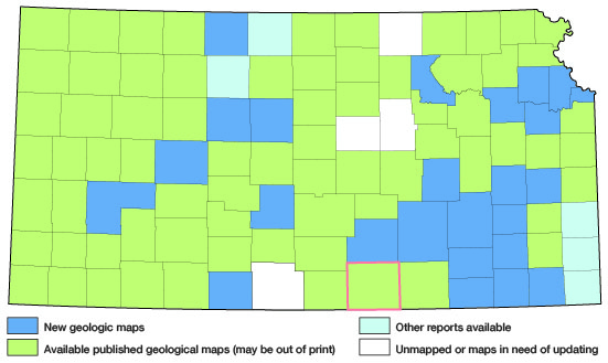
Sumner County is in the first row of counties north of Oklahoma and is about midway between the east and west borders of Kansas (Fig. 1). It is bordered on the east by Cowley County, on the north by Sedgwick County, on the west by Kingman and Harper Counties, and on the south by Grant and Kay Counties, Oklahoma. The county has an area of about 1,183 square miles, extending 36 miles from east to west and about 33 miles from north to south.
Figure 1--Index map of Kansas showing area described in this report and areas covered by other geologic maps, as of Jan. 2003. For additional information, please visit the KGS Geologic Maps of Kansas Page.
Previous Investigations
Among the early geologic workers in south-central Kansas, F.W. Cragin (1885) named and described the Wellington Formation. Bass (1926) described the structure and limits of the Kansas salt beds with special reference to the Wellington Formation. Later (1929) Bass mapped the geology and prepared a report on geologic conditions in Cowley County. The geologic map of Kansas prepared by Moore and Landes (1937) shows the surface geology of Sumner County on a small scale. Landes (1937) also described the mineral resources of Sumner County and included a general description of the geology. Norton (1939) named the Ninnescah Shale in a report on the Permian redbeds of Kansas. The surface and subsurface rocks of Kansas were described by Moore and others (1951). Frye and Leonard (1952) described the Pleistocene geology of Kansas and made several specific references to Sumner County. Swineford (1955) prepared a very detailed report on the petrography of the upper part of the south-central Kansas Permian rocks. A report by Kulstad and others (1956) on gypsum includes this area. Investigations of the geology and ground-water resources of adjacent counties, including Kingman County (Lane, 1960), Harper County (Bayne, 1960), Sedgwick County (Williams and Lohman, 1949; Lane and Miller, in preparation), and Cowley County (Bayne, in preparation) have been completed or are in progress.
Methods of Investigation
Most of the field work upon which this report is based was done during the summers of 1955 and 1956. In 300 wells the depth of the well and the depth to water below the land surface were measured with a steel tape (Table 11). Well owners and well drillers were asked the lithology and thickness of the water-bearing materials penetrated in the wells. Information pertaining to the yield of wells and the quality of the water was obtained where possible. Special effort was made to inventory all irrigation, municipal, and industrial wells, but only representative stock and domestic wells were inventoried.
In areas where information was not available from wells or where special water-supply problems existed, 296 test holes were drilled with a power auger or a portable hydraulic-rotary rig owned by the State Geological Survey and operated by E.L. Reavis, Dwane Anderson, and William Gellinger. Samples of drill cuttings collected from some of these holes were studied in the field and later were examined in the laboratory under binocular microscope. Logs of 66 test holes drilled by contractors are included in this report. The altitudes of the measuring points of the wells and test holes were determined with a planetable and alidade by E.L. Reavis.
During the investigation, 234 water samples were collected from wells, test holes, and streams; 71 samples from wells were given a comprehensive chemical analysis and 148 samples from wells and 15 samples from streams were analyzed only for content of chloride or chloride and sulfate. Some of the analyses are of samples collected in 1944, but most are of those collected during this investigation.
Twenty-five observation wells were installed in 1954 in the valley of Arkansas River near Mulvane to determine what effect pumping by the cities of Augusta and El Dorado would have on the water level. The wells are measured periodically, and hydrographs are included in this report.
Geology was mapped on aerial photographs from observations in the field and from stereoscopic study of the photographs. The mapping was later transferred from the aerial photographs to a base map made from a county map prepared by the Soil Conservation Service.
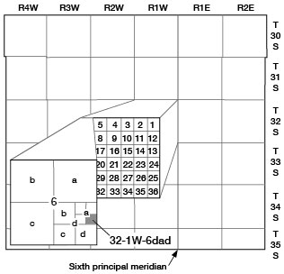
Well-numbering System
The wells and test holes in this report are numbered according to their location as determined by the General Land Office system of land classification. The component parts of a well number indicate respectively the township, the range, the section, and subdivisions of the section. The first small letter denotes the quarter section, the second denotes the quarter-quarter section, and the third denotes the 10-acre tract; these are designated in a counterclockwise direction, beginning in the northeast quadrant. If two or more wells are within the same 10-acre tract, they are numbered serially according to the order in which they were inventoried. All the townships in Sumner County are south of the base line, hence no letter designation of north or south is necessary; however, as the county extends both east and west of the sixth principal meridian, the range number is followed by "E" or "W". An example of the well-numbering system is given in Figure 2.
Figure 2--Map of Sumner County, Kansas, illustrating the well-numbering system used in this reports. The well is in sec. 6, T 32 S, R 1 W.
Acknowledgments
Appreciation is expressed to the many persons who co-operated and assisted in the collection of field data. The city officials were helpful in supplying information concerning their municipal wells. Many landowners in the county supplied information pertaining to the yield of their wells and were very cooperative in allowing tests to be made or test drilling to be done. Special thanks are extended to Latta and Fent of Salina (now known as the Hydraulic Drilling Co.) for making available the logs of test holes in the Wellington well field.
The manuscript of this report has been reviewed critically by several members of the Federal and State Geological Surveys; by Robert V. Smrha, Chief Engineer, and George S. Knapp, Engineer, Division of Water Resources, Kansas State Board of Agriculture; and by Dwight F. Metzler, Chief Engineer, and Willard O. Hilton, Geologist, Division of Sanitation, Kansas State Board of Health.
Prev Page--Contents || Next Page--Geography
Kansas Geological Survey, Geology
Placed on web January 2003; originally published August 1961.
Comments to webadmin@kgs.ku.edu
The URL for this page is http://www.kgs.ku.edu/General/Geology/Sumner/02_intro.html