![]()
Prev Page--Pennsylvanian, Missourian || Next Page--Neogene
Pennsylvanian System--Virgilian Stage
Douglas Group
Stranger Formation
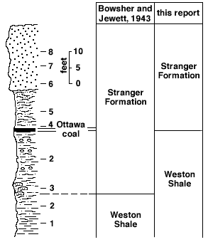
The Stranger Formation (Newell, in Moore, 1932, p. 93) includes all strata from the base of Virgilian rocks to the base of the Lawrence Shale (Moore, 1949, p. 129). Both of its stratigraphic boundaries are locally disconformable. In ascending order the members of the Stranger are: Tonganoxie Sandstone, Westphalia Limestone, Vinland Shale, Haskell Limestone, and Robbins Shale (Pl. 2).
Tonganoxie Sandstone Member--It is not possible to delimit accurately the Tonganoxie Sandstone (Moore and others, 1934) throughout most of Franklin County. Evidence of a disconformity separating Missourian and Virgilian strata is scanty. The Westphalia Limestone, which overlies the Tonganoxie Sandstone in most exposures of these strata in Kansas south of Franklin County, crops out in only one place (SE corner sec. 17, T. 19 S., R. 18 E.) within the county. Consequently, the name Tonganoxie is applied to the lower part of the section between the Weston Shale below and the Haskell Limestone above. The approximate thickness range of the Tonganoxie is 3 to 50 feet. In some parts of northeastern Kansas the contact between Tonganoxie Sandstone and older strata is sharp; however, no such exposures were noted in Franklin County, although the Weston Shale-Tonganoxie Sandstone part of the section is well exposed at the following localities: NW corner SW sec. 34, T. 15 S., R. 20 E.; center south line sec. 7, NE NW sec. 16, and center west line SW sec. 14, T. 17 S., R. 19 E.; and SW NW sec. 19, T. 18 S., R. 19 E.
Sandstone-shale pebble conglomerate, massive sandstone, sandy and silty shale, siltstone, and coal form the Tonganoxie, which comprises one or more of these lithologies in its exposures in the county. Possibly the Tonganoxie is absent in the greater part of T. 15 S. At one locality (near center east line SE sec. 25, T. 15 S., R. 20 E.) a sandstone-shale pebble conglomerate is poorly developed near the base of the Tonganoxie. Massive, in part cross-stratified, very fine to fine-grained quartzose siltstone and sandstone constitute a part of the Tonganoxie in many exposures (e.g., sections C3, C7, and C8).
Samples taken at the center west line SW sec. 14, T. 17 S., R. 19 E., were studied petrographically. Near perfect size gradation from clayey shale devoid of silt (Fig. 6, lithology 1), through silty shale (Fig. 6, lithology 2), micaceous fine- to medium-grained siltstone (Fig. 6, lithology 4; Pl. 8A), medium- to coarse-grained siltstone (Fig. 6, lithology 5; Pl. 8B), very fine to fine-grained sandstone (Fig 6, lithology 6; Pl. 8C), fine-grained sandstone (Fig. 6, lithology 7; Pl. 8D), and fine- to medium-grained sandstone (Fig. 6, lithology 8; Pl. 8E), was noted. Continuity of gradation is interrupted by limestone-shell "hash" conglomerate (Fig. 6, lithology 3; Pl. 8F) and the Ottawa coal (Fig. 6, just below lithology 4).
Plate 8--Photomicrographs of thin sections of the Tonganoxie Sandstone Member of the Stranger Formation (Fig. 6). A-E, X200, crossed nicols. A, Lithology 4, micaceous fine- to medium-grained siltstone. B, Lithology 5, medium- to coarse-grained siltstone. C, Lithology 6, very fine to fine-grained sandstone. D, Lithology 7, fine-grained sandstone: E, Lithology 8, fine- to medium-grained sandstone. F, Negative print of lithology 3, silt-cemented limestone-shell "hash" conglomerate, X5. Note absence of shell "hash" from limestone granules and pebbles.
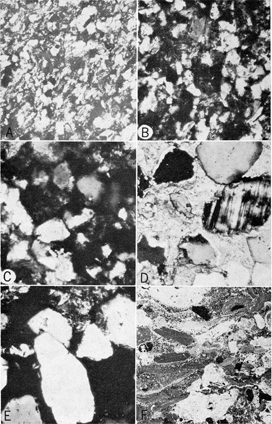
Figure 6--Section exposed at the center west line SW sect. 14, T. 17 S., R. 19 E. Numbers designate positions of lithologies referred to in the text.
The quartz grains of lithologies 4 through 8 (Fig. 6 and Pl. 8) are well sorted, subangular to rounded to quite irregular in shape, and moderately to tightly packed. Many quartz particles contain impurities and have quartz overgrowths; most grains exhibit uniform extinction under crossed nicols but some show a mosaic pattern and may be metaquartzite. In these 5 samples the amount of mica flakes ranges from about 1 to 10 percent. Feldspars form from 1 to 3 percent and unidentified heavy minerals about 2 percent of each sample. Silica is the main cementing material, but the quartz grains of lithology 7 (Fig. 6) are calcite cemented.
Trough-type cross stratification in the sandstone parts of the Tonganoxie comprises lenticular and wedge-shaped sets of cross strata that range from about 0.5 to 5 feet in thickness. The cross strata are medium scale (length 1 to 20 feet), low angle (less than 20 degrees), and they have a maximum thickness of about 2 inches. Measurements of cross-strata trends in the Tonganoxie of Franklin County indicate a dominant trend approximately S 43 deg. W and another trend approximately S 27 deg. E (Richard Bower, 1960, written communication). Siltstone parts of the Tonganoxie Sandstone are even to wavy bedded. Individual siltstone beds range from 0.1 to 0.5 foot in thickness and commonly are cross laminated. The cross lamination is of such small scale that it is not readily apparent on the outcrop.
The Ottawa coal lentil of the Tonganoxie Sandstone is a bituminous coal and ranges in thickness from about 0.3 to 0.8 foot. A detailed lithologic description of this coal was given by Bowsher and Jewett (1943, p. 41-42).
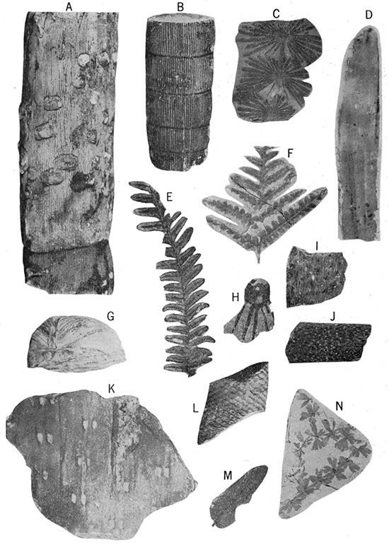
Fossils in the Tonganoxie include abundant and well-preserved land plant remains (Pl. 9) and sparse fragments of either pelecypod or brachiopod valves. The invertebrate fossils were noted only in a thin section made from a sample of lithology 7 (Fig. 6). Original shell structure has been entirely obliterated by recrystallization, leaving only the shell outline bounding a mosaic of coarsely crystalline calcite.
Plate 9--Plant fossils from Tonganoxie Sandstone Member of Stranger Formation. A and B, Calamites (X 1/2). C, Annularia (X 5/8). D, Cordaites (X 3/8). E and F, Alethopteris (X 1/2). G, Daubreeia (X 1/2). H, I, and J, Stigmaria (X 1/2). K, Sigillaria (X 3/8). L, Lepidodendron (X 1/2). M, Neuropteris (X 5/8). N, Sphenophyllum (X 5/8). Specimens, except D, collected from center SW sec. 14 and center north line sec. 23, T. 17 S., R. 19 E. Specimen D collected from center south line SW sec. 9, T. 17 S., R. 19 E. A, C, D, F, G, and K loaned from the personal collection of A. C. Carpenter, Ottawa, Kansas.
The exposure at the center west line SW sec. 14, T. 17 S., R. 19 E., has long been known for its excellent plant fossils. The possibility that this siltstone and sandstone which contain the well-preserved plant fossils should be assigned to the Ireland Sandstone Member of the Lawrence Shale and not to the Tonganoxie Sandstone Member of the Stranger Formation has been brought to the attention of the authors by several geologists. The apparent absence of the Westphalia and the Haskell Limestones in the immediate vicinity, both of which are younger stratigraphically than the Tonganoxie but older than the Ireland, precludes unequivocal settlement of the question. However, stumps and trunks of trees rooted in the Ottawa coal, which no one has ever doubted to be a part of the Tonganoxie, were preserved in the upright position of growth, having been buried before they had time to rot away or fall. One such tree was illustrated by Bowsher and Jewett (1943, p. 28). Also, at this exposure a number of fossilized twigs and branches, which cut stratification surfaces at angles of about 90 degrees, were collected by S.M. Ball and others from the basal 5 to 10 feet of the siltstone and sandstone. The age of the siltstone and sandstone and that of the Ottawa coal are, geologically speaking, very nearly the same. Therefore, all strata exposed at this locality (center west line SW sec. 14, T. 17 S., R. 19 E.) above the base of the Ottawa coal are classed in this report as Tonganoxie Sandstone.
Westphalia Limestone Member--The only outcrop of the Westphalia Limestone (Moore and Newell, in Moore, 1936, p. 150) definitely recognized in Franklin County is on the Franklin-Anderson county line (SE corner sec. 17, T. 19 S., R. 18 E.). There the member is a dense, brown, flaggy-bedded, argillaceous limestone 2.4 feet thick. It grades upward from shaly limestone that contains profuse crinoid remains and bryozoan and brachiopod fragments into lamellar, pseudobrecciated, dense limestone. This dense upper part of the limestone bears fusulinids and other foraminifers, Osagia, and mollusks. Composita is the only genus that was identified among the shell fragments in the lower shaly part. At several other exposures (e.g., center north line NW 1/4 sec. 22, T. 15 S., R. 20 E.) a gray, laminated, silty and carbonaceous limestone crops out and is thought to be correlative with the Westphalia. This rock is exposed as far south as one-half mile into Franklin County, but only poorly so. The stratigraphic position of the Westphalia at all places observed between these two areas is occupied by plant-bearing silty shale and sandstone with septarian concretions.
Vinland Shale Member--Where the Westphalia Limestone is missing, the Vinland Shale (Patterson and Addison, 1933, p. 17) is considered the upper part of the section between the base of Haskell Limestone above and the top of the Weston Shale below. Strata to which the name Vinland Shale is applied range in thickness from about 11 to 13 feet.
In one exposure (center north line sec. 31, T. 17 S., R. 19 E.), what is probably Vinland Shale contains Aviculopecten, Chonetes, Crurithyris, and sparse lophophyllid corals. The upper 10 feet of the Vinland is exposed, bounded above by the Ireland Sandstone, but the base of the member was not identified at this location.
Near the center west line of sec. 19, T. 18 S., R. 19 E., the Vinland consists of non-fossiliferous, sandy to silty, micaceous, gray shale with a distinctive zone of large blue-gray calcareous septarian nodules near its base. There the Vinland is approximately 13 feet thick; it is immediately below the Haskell Limestone and overlies the Tonganoxie Sandstone.
In outcrops of the Vinland Shale in T. 15 S., R. 19 E. and R. 20 E., a zone abundant in Myalina and other clams forms the uppermost 2 feet of the member. Even-bedded, highly resistant, fine-grained to very fine grained, quartzose sandstone beds, and a red tinge on fresh bedding surfaces of the shale are characteristic of the Vinland in this area.
In the SW sec. 12, T. 18 S., R. 18 E., the Vinland Shale is approximately 11 feet thick and contains the previously mentioned zone of large calcareous septarian nodules near its base. The shale is bluish and clayey, and it is poorly bedded in the basal part. Higher it is calcareous and is almost a shaly limestone at the top, where there is a development of good shaly bedding. This exposure is paleontologically one of the most interesting in the county. Profuse clams, gastropods, michelinoceroid cephalopods, brachiopods, and land plant remains are distributed throughout the upper half of the Vinland. Bits of bryozoans and crinoids are also common. Genera identified include the clams Astartella, Aviculopecten, and Myalina; the spired gastropod Worthenia; the cephalopod Mooroceras; and the brachiopods Chonetes, Composita, and Derbyia. Derbyia occur throughout the shale and some are pasted like stamps on an envelope on the upper surface of a small number of ellipsoidal septaria. No Derbyia are found within the septaria or on their lower surfaces. In the only case in which a Derbyia was found covering a part of the junction between a septarian crack and the nodule periphery, the fossil was uncracked. Therefore, the nodule apparently formed and a crack system developed before the Derbyia was emplaced.
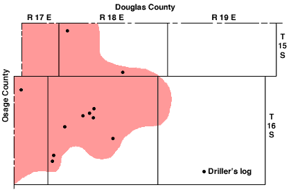
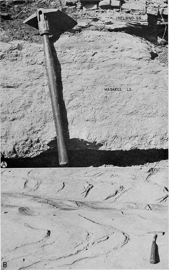
Haskell Limestone Member--The Haskell Limestone (Moore, 1932, p. 93) is the most persistent marker between the top of the Stanton Limestone and the base of the Oread Limestone in Franklin County. Its absence in the subsurface (Fig. 7) and apparent absence locally at the surface (center north line NW 1/4 sec. 19, T. 15 S., R. 20 E.; center north line sec. 31, and SW 1/4 sec. 7, T. 17 S., R. 19 E.; SE corner NW 1/4 SE 1/4 sec. 11, and the greater part of sec. 12, T. 17 S., R. 18 E.) may be the result of erosion prior to deposition of the Ireland Sandstone. In many parts of Kansas the Haskell caps a prominent escarpment, but in Franklin County this member is topographically inconspicuous. The Ireland Sandstone immediately overlies the Haskell in some exposures, but in others a small thickness of Robbins Shale separates these members. A great volume of colluvial material derived from the Ireland Sandstone tends to conceal the Haskell outcrop, making it appear to be more discontinuous than it is.
Figure 7--Map of the northwestern part of Franklin County showing locations of wells for which drillers logs indicate absence of Haskell Limestone, and generalized area (shaded) in which the Haskell is probably absent in the subsurface.
The Haskell Limestone forms a slabby, vertically jointed ledge of dense blue-gray limestone about 2 feet thick. The upper and lower parts of the member weather through a thickness of about 6 inches into irregular plates 1 inch or less thick. Commonly the upper surface is covered by weathered brown clayey shale containing goethite shards derived from the overlying Robbins Shale. The fauna of the Haskell differs from the base to the top of the member. Profuse small fusulinids in the lower half of the Haskell and a mixed fauna of crinoids, brachiopods, and planispiral gastropods in the upper half are characteristic. The brachiopods Meekella, Neospirifer, Composita, Derbyia, and Chonetes, in order of apparent abundance, were identified. The alga Ottonosia is distributed throughout the member.
Robbins Shale Member--Robbins Shale (Moore and Newell, in Moore, 1936, p. 155) is represented in much of its area of outcrop by scattered occurrences of highly weathered shale and goethite overlying the Haskell Limestone. Only the lower 1 foot or less of the Robbins is exposed in most outcrops. At such places the shale is highly weathered, brown, and clayey with poorly defined lamination. In most places the upper contact of the Robbins is concealed by colluvial material slumped down from the Lawrence Shale. Local absence of the Robbins Shale in surface exposures (e.g., SW SE sec. 13, T. 17 S., R. 18 E.) is the result of pre-Ireland erosion (Pl. 10A). At several localities (e.g., SE corner sec. 15, T. 17 S., R. 18 E., and SE sec. 26, T. 15 S., R. 19 E.) where a definite Robbins top is defined by basal Ireland strata, the Robbins consists of blue-gray clayey shale that ranges from 0 to 17 feet in thickness.
Despite its state of weathering, the Robbins has certain distinctive characteristics, and, as pointed out by Miller and Swineford (1957), the member is of paleontologic interest. A zone of white-weathering phosphatic concretions at the base of the unit contains various parts of paleoniscid fish, small ammonoid cephalopods, fish brain casts, and coprolitic material. The nodules are most commonly found loose in weathered shale above the Haskell Limestone, along with numerous bits of goethite, which constitute a second characteristic. A goethite layer commonly overlies the nodulose zone, but in places the goethite is in contact with the Haskell.
Plate 10--A, Disconformity at the base of Ireland Sandstone Member of Lawrence Shale, SW NW SE sec. 11, T. 17 S., R. 18 E. B, Cross-stratified Ireland Sandstone, center north line NW sec. 16, T. 17 S., R. 18 E.
Lawrence Shale
Haworth (1894b, p. 122) introduced the term Lawrence Shale. Moore and Newell (in Moore, 1936, p. 154) redefined the formation to include only those beds between the bases of the Ireland Sandstone and the Oread Limestone. The Lawrence Shale contains two named members, the Ireland Sandstone and the Amazonia Limestone. In Kansas the Amazonia Limestone has been definitely recognized only in Doniphan and Atchison Counties; the Amazonia was not identified in Franklin County. In the southern half of T. 18 S. and in T. 19 S. the Ireland Sandstone is not recognized and the term Lawrence Shale is applied to all strata between the Haskell and Toronto Limestones.
Ireland Sandstone Member--In this report the term Ireland Sandstone (Moore, 1932, p. 93) applies to predominantly sandstone lithology in the lower part of the Lawrence Shale. The base of the Ireland Sandstone is locally either gradational or disconformable; it is mapped at the top of Robbins Shale, at the top of Haskell Limestone, and as low stratigraphically as the upper part of Vinland Shale. Silty shale bounds the Ireland laterally and above. Neither the upper nor lower contact represents a single stratigraphic horizon.
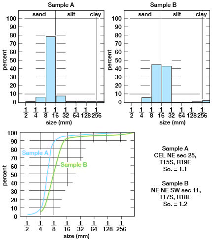
Sandstone, siltstone, silty shale, claystone, clayey shale, coal, and sandstone-limestone-shale pebble conglomerate (in order of decreasing volume) constitute the Ireland. Tan subangular to subrounded quartz sand and silt particles and flakes of mica, cemented by both calcium carbonate and silica, form the sandstone. The matrix commonly has been leeched and the sandstone is extremely friable. Outcrop examination and size analyses (Fig. 8) indicate that very fine sand is the predominant size grade. Sand of the Ireland is extremely well sorted (sorting coefficients for samples analyzed range from 1.1 to 1.2). Locally the sandstone is disconformable on and separated from older strata by a sharp contact (e.g., SE corner sec. 15, and near center SE 1/4 sec. 12, T. 17 E., R. 18 E.; and center south line sec. 7, T. 17 S., R. 19 E.). At the last of these localities the lower 2 feet of the Ireland consists of a limestone-sandstone-shale pebble conglomerate. Chonetid brachiopods within the conglomerate at this and nearby exposures (Pl. 10A) indicate that part of the conglomerate was probably derived from the Haskell Limestone.
Figure 8--Size analyses of sandstone of the Ireland Sandstone Member. Histograms above and cumulative curves below. Sorting coefficients indicated by So.
In a number of places (west side NW sec. 13, SE corner SW SW sec. 15, and near center west line sec. 15, T. 17 S., R. 18 E.) strata above the Haskell Limestone grade upward from clayey shale through silty shale and siltstone to sandstone within the Ireland Sandstone. The sandstone of the Ireland grades laterally and upward into siltstone and silty shale.
Bedding varies from very thin to thin, relatively even beds, ranging from 2 inches to 2 feet in thickness, to massive, in part cross-stratified, beds as much as 10 feet thick. Only a few exposures (e.g., NW NE sec. 14, T. 16 S., R. 19 E.) offer an opportunity for obtaining enough measurements to determine a range of the scale of cross stratification. Cross stratification in the Ireland is of the trough type (Pl. 10B) and comprises lenticular and wedge-shaped sets of cross strata that range from about 0.7 to 5 feet in thickness. The medium-scale (length 1 to 20 feet), low-angle (less than 20 degrees) cross strata are 2 inches or less in thickness; most of the cross strata are less than 1 inch thick. The dominant trend of cross stratification approximates S 48 degrees W (Richard Bower, 1960, written communication). Examination of the internal structure of individual cross strata and individual strata in which bedding is even revealed microscopic cross lamination in many exposures.
The lower Williamsburg coal, which occurs locally about 20 to 40 feet below the top of the Ireland, is the most persistent coal within the member. The lower Williamsburg is commonly a shaly bituminous coal which contains many thin clayey shale partings and ranges from 0 to 1.6 feet in thickness.
In the southern half of T. 18 S. and in T. 19 S. the Ireland Sandstone is not recognized; there gray and tan silty shale and minor amounts of siltstone occupy its stratigraphic position. The Ireland Sandstone ranges from 0 to about 100 feet in thickness.
Upper Part of Lawrence Shale--The section above the Ireland Sandstone and below the Toronto Limestone comprises silty shale, clayey shale, sandstone, a number of limestone lenses, and a number of coal lenses (Pl. 2C); gray silty shale is the dominant rock type. Where the upper part of the Lawrence Shale can be recognized in Franklin County, north of the east-west center line of T. 18 S., it ranges from about 40 to 60 feet in thickness.
In Franklin County and several other counties in Kansas south of Doniphan County, the occurrence of a zone of limestone lenses in the upper part of the Lawrence Shale is common and characteristic. It has become common practice to correlate these limestone lenses with the Amazonia Limestone (Hinds and Greene, 1915, p. 31, 170) whose type section is in southern Andrew County, Missouri. Limestone lentils in the upper Lawrence Shale of Franklin County and the southernmost definite Amazonia Limestone are widely separated geographically. Lithologic aspects of these limestone lenses in Franklin County differ radically from one another and from the lithologically quite uniform Amazonia Limestone. The practice of correlating a number of different limestone lenses in the upper part of the Lawrence Shale across Kansas to the Amazonia is not justifiable.
Along the Franklin-Anderson county line (SW SE sec. 18, T. 19 S., R. 18 E.) a limestone lens which is brownish gray, devoid of internal bedding, and 1 foot thick crops out; it contains Neospirifer, myalinid clams, crinoid stems, and bryozoans. There the upper contact of the limestone is about 26 feet below the base of the Toronto Limestone and about 8 feet below the base of the upper Williamsburg coal.
About 1 mile southwest of Williamsburg (near center east line NW sec. 24, T. 18 S., R. 17 E.) a lenticular limestone crops out about 37 feet below the base of the Toronto Limestone and about 1 foot below the base of the upper Williamsburg coal. There the limestone is about 1.6 feet thick, light gray, and dense; it contains many small pellets which may be ostracodes, algae, or both.
In the SW SE sec. 15, T. 17 S., R. 18 E., a gray, arenaceous, platy limestone, 1 foot thick, crops out about 13 feet below the Toronto Limestone and about 5 feet below the upper Williamsburg coal. No fossils were observed in the limestone at that locality. At the center of the south line sec. 32, T. 15 S., R. 18 E., a 0.6-foot, blue-gray arenaceous limestone occurs less than 1 foot above a coal thought to be the upper Williamsburg, and about 39 feet below the base of the Toronto Limestone.
The upper Williamsburg coal is a somewhat persistent marker south of the Marais des Cygnes River. This coal is about 18 inches thick in the vicinities of Ransomville and Williamsburg, but it thins and is discontinuous to the north and south in Franklin County. Relatively hard, massive and thinly bedded, bituminous coal, which has variable clay content and is rather shaly in places, forms the upper Williamsburg.
Tan silty shale, siltstone, and coal seams compose the section between the upper Williamsburg coal and the Toronto Limestone. Of these lithologies only the silty shale persists throughout the county (Pl. 2C).
A zone of red shale or mudstone crops out locally in the upper part of the Lawrence Shale; in the NW corner sec. 32, T. 15 S., R. 18 E., this zone is about 13 feet below the base of the Toronto Limestone. Red shale in approximately the same stratigraphic position is common across the state.
Shawnee Group
Oread Limestone
General continuity and relatively unchanging lithology are salient features of the Oread Limestone in Franklin County. However, missing beds, minor faulting, and facies change within the formation are noted (Pl. 2D). Representative measured sections are given below.
| Measured section of the Oread Limestone exposed in a road cut along the E line SE SE sec. 7, T. 16 S., R. 18 E. | Thickness (feet) |
||
|---|---|---|---|
| Kanwaka Shale (not exposed) | |||
| Oread Limestone | |||
| Kereford Limestone Member | |||
| Limestone, gray to tan on both fresh and weathered surfaces, bedding indistinct, weathers into irregular thin slabs, microcrystalline and compact in upper 3 feet, shaly in lower 3 feet; Composita, Dielasma, bryozoans, crinoids, abundant fusulinids; thickness exposed | 6.0 | ||
| Heumader Shale Member | |||
| Shale, gray, clayey to silty, weathers into flakes; sparse limonite concretions in upper half; lower 10 feet covered; about | 26.0 | ||
| Plattsmouth Limestone Member | |||
| Limestone, light gray on both fresh and weathered surfaces, thin wavy bedding, microcrystalline; brachiopods, bryozoans, crinoids; thickness exposed | 5.0 | ||
| Measured section of the Oread Limestone exposed in a road cut near the cen. E line sec. 31, T. 18 S., R. 18 S. | Thickness (feet) |
||
|---|---|---|---|
| Kanwaka Shale (not exposed) | |||
| Oread Limestone | |||
| Plattsmouth Limestone Member | |||
| Limestone, bight gray on both fresh and weathered surfaces, fine grained, compact, thin irregular bedding; Chonetes, Derbyia, Lophophyllidium, Neospirifer, bryozoans, crinoids; thickness exposed | 6.0 | ||
| Heebner Shale Member | |||
| Shale, dark gray to black, clayey to silty, weathers into fissile to platy beds: conodonts; about | 4.0 | ||
| Leavenworth Limestone Member | |||
| Limestone, blue gray, extremely dense, fractures conchoidally, vertically jointed; weathers into 2 distinct beds, a lower 0.5-foot bed and an upper 1.5-foot bed; brachiopods, clams, crinoids, fusulinids, Osagia-coated shell fragments in lower bed | 2.0 | ||
| Snyderville Shale Member | |||
| Shale, gray green, clayey to silty, bedding indistinct, weathers into flakes in upper part; about | 9.0 | ||
| Toronto Limestone Member | |||
| Limestone, gray to brown on both fresh and weathered surfaces, fine grained, compact, thin to thick rubbly beds in lower 3 feet, thick beds above; Chonetes, dictyoclostids, Compostia, Derbyia, Neospirifer, Punctospirifer, Syringopora, abundant fusulinids, ramose bryozoans; about | 11.0 | ||
| Lawrence Shale | |||
Toronto Limestone Member--The lowermost member of the Oread Limestone is the Toronto Limestone (Haworth, 1894a, p. 117). Except for a small area in the northwestern part of the county (T. 15 and 16 S., R. 18 E.) the Toronto is continuous across Franklin County. Typically the Toronto is a massive, thin- to thick-bedded, ochroid, ferruginous limestone, 8 to 12 feet thick, which weathers into slabs and irregular fragments, thus imparting a false aspect of thin irregular bedding, especially in the uppermost 2 to 3 feet of the ledge. Fusulinids, brachiopods, and crinoids are distributed throughout the member; these fossils weather white in marked contrast to the brown matrix. The fusulinids are concentrated mainly in the lower and upper few feet of the Toronto. The lowermost and uppermost parts of the member are gradational into adjacent strata through thicknesses of about 0.5 foot.
The Toronto is atypically developed in a number of places in northwestern Franklin County. The lower 2 to 4 feet of the Toronto in some exposures (e.g., SW corner sec. 29, and SE corner NE 1/4 sec. 31, T. 15 S., R. 18 E.) consists of a gray, dense, sparsely fossiliferous limestone (Pl. 11A). In the southern part of T. 17 S., R. 17 E. (center SW 1/4 sec. 23 and SW corner sec. 25), a gray limestone about 10 feet thick is correlated tentatively with the Toronto. This rock contrasts with typical Toronto Limestone in that it has a higher silt content, is more fossiliferous, lacks abundant fusulinids, and contains Lingula and ostracodes in the upper part. A gray, dense, coarsely crystalline limestone 2 feet thick occupies the stratigraphic position of the Toronto at the center east line sec. 4, T. 18 S., R. 18 E. There the limestone is composed primarily of tiny crinoid columnals and lesser amounts of algal and foraminiferal material. O'Connor (1960, p. 38) has noted exposures of atypical Toronto north of Baldwin in southern Douglas County.
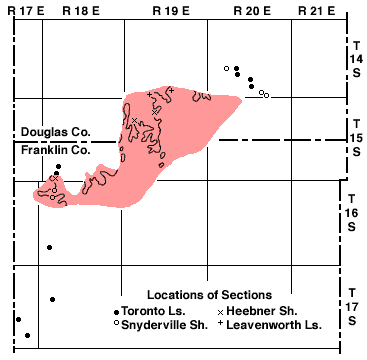
The area in southern Douglas County and northern Franklin County in which the Toronto Limestone is absent, known exposures of atypical Toronto Limestone, and locations of other stratigraphic anomalies within the Oread Limestone are shown in Figure 9.
Plate 11--Road cut exposures of Oread Limestone. A, Atypical lithology in lower part of Toronto Limestone Member (section D15), SW corner sec. 29, T. 15 S., R. 18 E. B, Coal seam in Snyderville Shale Member, NW corner sec. 5, T. 16 S., R. 18 E.
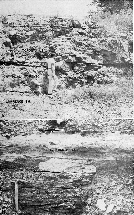
Figure 9--Map of southern Douglas County (from O'Connor, 1960, p. 66-67) and northern Franklin County showing generalized area (shaded) in which Toronto Limestone Member is absent, and locations of stratigraphic anomalies in Oread Limestone members. Outcrop pattern of Leavenworh Limestone Member is shown within the shaded area.
| Sec. | T. S. | R. E. | Sec. | T. S. | R. E. | ||||
|---|---|---|---|---|---|---|---|---|---|
| SW | 21 | 14 | 20 | SE SW | 20 | 14 | 20 | ||
| SW SW NW | 27 | 14 | 20 | NE SE | 34 | 14 | 20 | ||
| SW cor. NW SW | 27 | 14 | 20 | SW SW | 35 | 14 | 20 | ||
| NW | 28 | 14 | 20 | SE SE | 6 | 16 | 18 | ||
| SW SW | 29 | 15 | 18 | CEL | 7 | 16 | 18 | ||
| SE SE NE | 31 | 15 | 15 | Near cen. SE | 7 | 15 | 19 | ||
| NW NE SE | 30 | 16 | 15 | NW NW | 9 | 15 | 19 | ||
| Cen. SW | 23 | 17 | 17 | CWL | 32 | 15 | 18 | ||
| SW SW | 25 | 17 | 17 | Cen. SE | 32 | 14 | 19 | ||
| Near CEL | 18 | 17 | 18 | SE SE NW | 34 | 14 | 19 |
Snyderville Shale Member--The Snyderville Shale (Condra, 1927, p. 38) immediately overlies the Toronto Limestone or, where the latter is absent, the Lawrence Shale. Except at one exposure (Pl. 2, section D15), the member is apparently continuous throughout the county, ranging in thickness from about 9 to 30 feet.
Alternating layers of tan to gray-green silty shale, tan silty claystone, siltstone, and nodular, relatively impure, fossiliferous limestone make up the Snyderville. The claystone, siltstone, and limestone are discontinuous units. However, in the majority of well-exposed sections north of Williamsburg, at least one of these lithologies is present. Where the upper few feet of the Snyderville is well exposed (see Pl. 11), it consists of a thin coal seam overlain by gray shale, which contains sparse fossil brachiopods and clams.
At D11 and D12 (see Stratigraphic Sections), where the Toronto Limestone is absent, 0.5 foot of fossiliferous limestone crops out 2 feet below the top of the Snyderville. The possibility that this limestone is the Toronto is precluded by the presence of both limestones in the same exposure in the SW 1/4 NW 1/4 sec. 18, T. 18 S., R. 18 E.
Claystone in the central part of the Snyderville in outcrops D2, D4, and D6 (Pl. 2) is 8.5, 3.5, and 17 feet thick, respectively, and probably is the result of weathering soon after deposition. A sample of the claystone was subjected to a standard clay-mineral analysis by x-ray diffraction. Examination disclosed that the sample contained approximately 85 percent illite, 8 percent calcite, quartz (minor), and an interlayered hydrated-mica unit (minor). Solely on the basis of the x-ray examination, it would seem that the sample does not represent altered shale. The source of the claystone was possibly a limestone (C.F. Kahle, 1959, written communication). O'Connor (1960, p. 40) noted this "fossil soil" of the Snyderville in southern Douglas County and suggested that it is the result of weathering of a part of the Toronto Limestone. The claystone at localities D4 and D6 (Pl. 2) was not derived by alteration of Toronto Limestone but may have been derived by weathering of limestone known to exist locally within the Snyderville Shale.
Leavenworth Limestone Member--The Leavenworth Limestone (Condra, 1927, p. 38) is the best "key bed" in Franklin County. Thickness and other lithologic aspects of the Leavenworth are almost unchanging. Except at one locality (Pl. 2, D 15), this member is continuous in Franklin County.
The following description is applicable to the Leavenworth in all exposures studied. This blue-gray limestone is a single, massive, even-surfaced ledge, which fractures conchoidally. When struck with a sledge, the bed commonly breaks along joints through its complete thickness into smooth-sided slabs. The fauna comprises sparse fusulinid, clam, snail, brachiopod, echinoid, and crinoid remains. Allorisma, Aviculopecten, and Ottonosta were identified from the Leavenworth. Thickness of the member ranges from 1.3 to 2.3 feet.
Heebner Shale Member--The Heebner Shale (Condra, 1927, p. 37) is continuous in Franklin County. Black platy to nearly fissile shale in the lower 1 to about 3 feet, overlain by gray to green clayey shale, forms the Heebner. The lower, dark part of this shale commonly is contiguous with the underlying Leavenworth, but in some exposures the two rocks are separated by 1 to 3 inches of gray siltstone. A conodont fauna which has numerous individuals but few genera occurs in the black shale. The genera Hindeodella, Streptognathodus, Ozarkodina, and Lonchodina are represented. The bar type conodonts, Hindeodella, are preserved with little distortion on the bedding surfaces of the shale, but many blade and platform-bearing Streptognathodus are bent or broken. The brachiopods Chonetes and Productella are found in the upper, gray to green part of the member. The thickness of the Heebner ranges from approximately 4 to 18 feet and averages about 6 feet.
Plattsmouth Limestone Member--The Plattsmouth Limestone (named by Keyes, 1899, p. 306, and more specifically defined by Condra, 1927, p. 37) is continuous throughout Franklin County. A complete thickness of the Plattsmouth is rarely accessible for study.
This light-gray, thin, and irregularly bedded, mostly aphanitic limestone typifies "upper" (Moore, 1936, p. 27-28) limestones. The gross lithology of the Plattsmouth is strikingly similar to that of the older Stoner, Spring Hill, Argentine, and Raytown Limestones. Position in sequence is the most distinguishing characteristic of the Plattsmouth. Individual beds range from about 2 inches to 1 foot in thickness, and thicker parts of a bed are commonly contiguous with thinner parts of adjacent beds. A variety of brachiopod genera, bryozoans, coelenterates, echinoderms, mollusks, and algae are present. The thickness of the Plattsmouth is approximately 20 feet.
Heumader Shale Member--Because of the susceptibility of the overlying Kereford Limestone to weathering, good exposures of the Heumader (Moore, 1932, p. 94-96) are rare. The member is apparently continuous in Franklin County.
Where observed, the Heumader consists of weathered calcareous shale with indistinct bedding. Examination in excavated outcrops revealed no fossils, and it is concluded that fossils apparently indigenous to the Heumader have weathered out of the overlying Kereford Limestone. Float in some exposures indicates the presence of thin, fucoidal, gray limestone somewhere in the Heumader. Thickness ranges from about 9 to 25 feet.
Kereford Limestone Member--The uppermost member of the Oread Limestone is the Kereford Limestone (Condra, 1927, p. 45). Although apparently continuous in Franklin County, exposures of the Kereford are few and nowhere was a complete thickness observed.
The lower half of the member is buff to gray wavy-bedded limestone which, because of impurities, weathers more like a shale than a limestone. Marly limestone fragments commonly weather free from the upper half of the Kereford. Brachiopods, bryozoans, small planispiral gastropods, profuse Osagia, and robust fusulinids are abundant in the Kereford, especially in the upper part of the member.
Because of this rock's susceptibility to weathering, an exposure showing a total thickness of the Kereford was not found. Data from drillers logs and measured sections indicate an average thickness of about ii feet. Being much less resistant to weathering than the Plattsmouth Limestone Member, Kereford outcrops are usually far back on the dip slope of the Oread cuesta. Where the underlying Heumader Shale is less than 10 feet thick, the Kereford is especially inconspicuous in the Oread Limestone escarpment.
Kanwaka Shale
A predominantly terrigenous detritus section, the Kanwaka Shale (Adams and others, 1903, p. 45), is subdivided into three members--Jackson Park Shale, Clay Creek Limestone, and Stull Shale--which are rarely well exposed in Franklin County.
Jackson Park Shale Member--Moore (1932, p. 94) designated the Jackson Park Shale as the lower member of the Kanwaka Shale. The member is continuous throughout Franklin County. Exposures are restricted to T. 15 and 16 S., R. 17 E., and a small area in T. 15 S., R. 18 E. Soil and vegetation cover the Jackson Park in most places. Where exposed, a gradually receding slope delimits its outcrop. The Jackson Park conformably overlies the Kereford Limestone and is conformably overlain by the Clay Creek Limestone. The entire member averages approximately 25 feet in thickness. The lower 10 to 15 feet of the member is gray, clayey to silty shale that contains land plant fossils. Tan calcareous shale with marine invertebrates such as brachiopods, bryozoans, and crinoids constitutes the upper part of the Jackson Park.
Clay Creek Limestone Member--The middle member of the Kanwaka Shale is the Clay Creek Limestone (Moore, 1932, p. 96). Few exposures of the member were observed, but it is apparently continuous in Franklin County. Fresh and weathered exposures of this member contrast sharply. In fresh exposures a single ledge with prominent vertical joints and devoid of shale partings is characteristic. In weathered exposures rapid disintegration causes jointing to become ill-defined. The fossils present are algae, brachiopods, bryozoans, and crinoids. The thickness of the Clay Creek ranges from 2 to about 4 feet. In an exposure at the center east line NE 1/4 NE 1/4 sec. 14, T. 16 S., R. 17 E., where the Clay Creek is nearly 4 feet thick, it is cross bedded in the upper 2 feet.
Stull Shale Member--Strata between the Clay Creek Limestone below and the Spring Branch Limestone of the Lecompton above form the Stull Shale (Moore, 1932, p. 96). The member is apparently continuous in Franklin County. The Stull consists mainly of tan silty to clayey shale that is locally sandy. Its thickness is approximately 30 feet. In the exposures studied it lacks megafossils, except for brachiopods and bryozoans in the upper 5 feet. In some exposures ironstone concretions are noted in the upper part of the member.
Lecompton Limestone
Only the lower two members of the Lecompton are exposed in Franklin County: the Spring Branch Limestone and the Doniphan Shale.
Spring Branch Limestone Member--The lowermost member of the Lecompton Limestone is the Spring Branch Limestone (Condra, 1927, p. 27). Lithologic aspects of the Spring Branch include dark-brown color, massive bedding, and abundant slender fusulinids. This limestone is compact but relatively impure, containing clay and quartzose sand impurities. The prominence of fusulinids on weathered surfaces and the abundance of fusulinids that weather free from the matrix are striking. Brachiopods and crinoids are common at most exposures. The thickness of the Spring Branch ranges from 5 to 7 feet.
Grossly the Spring Branch Member of the Lecompton and the Toronto Member of the Oread are strikingly similar, but in addition to position in sequence they differ in several respects. The Spring Branch is thinner, apparently has more fusulinids and fewer crinoid fragments, and is less pure.
Doniphan Shale Member--The Doniphan Shale (Condra, 1927, p. 47) is apparently the youngest bedrock unit exposed in Franklin County, and it is continuous. Tan clayey, silty, and sandy shale that is generally non-fossiliferous composes the Doniphan. Sparse mollusks were observed on shale slopes of the Doniphan in some exposures, but the position of these fossils in the shale was not ascertained. The thickness of the Doniphan in Franklin County is approximately 15 feet, which is slightly more than is common farther northeast in Kansas.
Prev Page--Pennsylvanian, Missourian || Next Page--Neogene
Kansas Geological Survey, Geology of Franklin County
Web version July 2002. Original publication date Jun. 1963.
Comments to webadmin@kgs.ku.edu
The URL for this page is http://www.kgs.ku.edu/General/Geology/Franklin/03_strat3.html