![]()
Prev Page--Neogene || Next Page--Economic Geology
Structural Geology
Regional Structure
Franklin County is in the structural province known as the Forest City Basin (Jewett, 1951, p. 135). Strata exposed in the county are a small part of the Prairie Plains Monocline (Jewett, 1951, p. 152), which comprises a great number of contiguous stratigraphic units dipping westwardly and northwestwardly away from the Ozark Dome of Missouri. The monocline is thought to be pre-Cretaceous and chiefly post-Permian in age. Numerous local dip reversals are superimposed on the regional dip, which is generally about 10 to 30 feet per mile.
Faulting
Several faults have been reported in southern Douglas County, northwestern Franklin County, and eastern Osage County (Rich, 1933a; O'Connor, in O'Connor and others, 1955; and Laughlin, 1957). O'Connor (1960, p. 63-69) has summarized these articles and has discussed in detail faulting in southern Douglas County. Two of the faults in northwestern Franklin County were mapped (Pl. 1).
West of Centropolis, in sec. 24 and 25, T. 15 S., R. 18 E., a generally north-trending fault was mapped. The stratigraphic sequence on the upthrown and downthrown sides of the fault is well exposed along the east-west county road between sections 24 and 25. There, a normal thickness of Toronto Limestone crops out on the west (upthrown) side. On the east (downthrown) side, the Toronto Limestone is absent and the rock section comprises Lawrence-Snyderville Shale, Leavenworth Limestone, Heebner Shale, and Plattsmouth Limestone. The Heebner Shale, which regionally averages about 6 feet in thickness, is about 17 feet thick on the downthrown side; the base of the Toronto on the upthrown side is about 30 to 40 feet above the top of the Leavenworth on the downthrown side.
A second fault affects upper Lawrence Shale and lower Oread Limestone strata near the center south line of sec. 19, T. 16 S., R. 18 E. On the southeast (upthrown) side of the fault (SW corner SE sec. 19, T. 16 S., R. 18 E.) the Toronto Limestone forms a prominent escarpment; 60 feet west of the escarpment, on the northwest (downthrown) side of the fault, the Leavenworth Limestone crops out 6 feet below the base of the Toronto when projected across the fault line. Thus, if an average thickness of Snyderville Shale is assumed, displacement approximates 30 feet, and the youngest unit definitely displaced is the Plattsmouth Limestone.
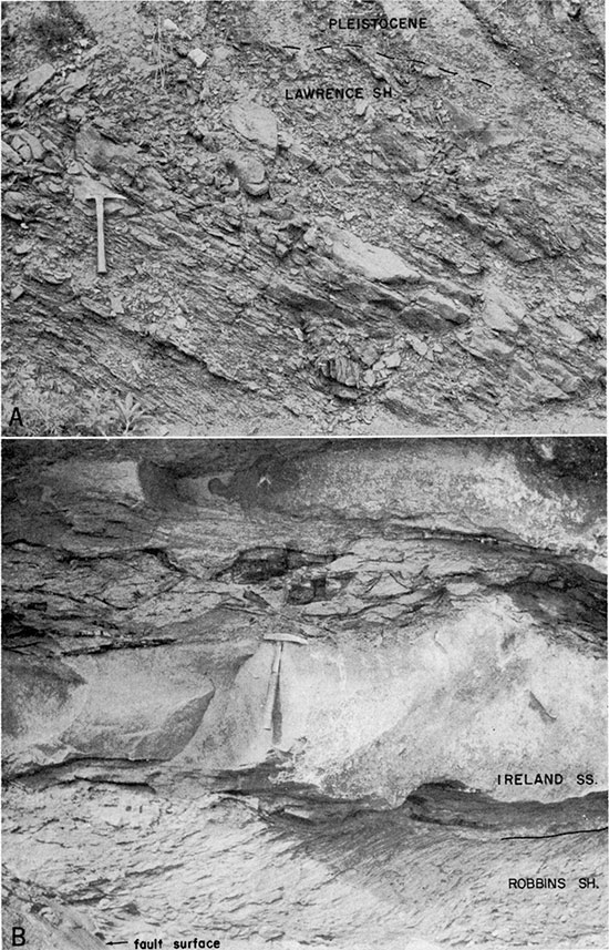
Near the center west line of sec. 32, T. 15 S., R. 18 E., faulting has affected the lower 3 members of the Oread Limestone and the upper part of the Lawrence Shale. There, on the east side of the road, strata from the upper part of the Snyderville Shale upward to within the Plattsmouth Limestone are exposed. The Heebner Shale, which regionally averages 6 feet in thickness, measures about 18 feet and comprises alternating black and gray-green shale (Pl. 2, section Dl4). West of the road, sandstone in the upper part of the Lawrence Shale and the Toronto Limestone have an apparent dip of about 25 degrees to the north (Pl. 12A). The Leavenworth Limestone on the east side of the road is at about the same elevation as that of the Toronto Limestone on the west side of the road. The probable age of the tilting and faulting is post-Leavenworth pre-Plattsmouth.
The upper part of the Lawrence Shale and the lower part of the Oread Limestone are well exposed at the SW corner of sec. 29, T. 15 S., R. 18 E. (Pl. 2, D15). There, the Oread sequence comprises, in ascending order: Toronto Limestone, Heebner Shale, and Plattsmouth Limestone. The Leavenworth Limestone and the Snyderville Shale are absent, but these rocks crop out in normal succession less than one-half mile in all directions from this exposure. Faulting may be in part responsible for the anomalous stratigraphic conditions seen at this locality, but the authors cannot explain adequately this stratigraphic sequence.
Plate 12--A, Apparent dip, about 25° N, of sandstone beds in upper part of Lawrence Shale at center east line sec. 31, T. 15 S., R. 18 E. Road cut exposure. B, Deformed stratification in Robbins Shale Member of Stranger Formation and coal fragments in Ireland Sandstone Member of Lawrence Shale at SE corner sec. 15, T. 17 S., R. 18 E. Streambank exposure.
Coal "Conglomerate"
For a distance of 50 feet along the west bank of Coal Creek (SE corner sec. 15, T. 17 S., R. 18 E.) the contact between the Ireland Sandstone and the Robbins Shale is well exposed. Angular coal fragments, clay pebbles, limestone pebbles, and laminae of coaly material are incorporated in the lowermost 4 feet of the Ireland; the limestone pebbles are restricted to the lowermost foot. Deformed stratification in the underlying Robbins Shale (Pl. 12B) in the northern half of the exposure indicates lateral sliding along the sandstone-clayey shale contact. Coaly material and sandstone laminae along bedding surfaces of the deformed Robbins Shale were not observed along bedding surfaces of the undeformed Robbins Shale in the southern part of the exposure. The deformed Robbins terminates abruptly at a fault surface (Pl. 12B). Apparently the sandstone laminae are intercalations of Ireland Sandstone injected along bedding surfaces of Robbins Shale during lateral sliding in water-rich semiconsolidated sediment. Similar structures, believed to have developed without the application of tectonic forces, have been described by Hills (1955), Richter-Bernburg (1953), and Fisk (1955).
Rich (1933b), after studying this exposure, concluded that: (1) the coal was not formed in place, (2) the unconformity at the base of the Lawrence Shale is stratigraphically below the Haskell Limestone Member of the Stranger Formation, and (3) the unconformity at the base of the Lawrence represents considerable geologic time.
The present authors' interpretations differ from those of Rich. The coal now seen at this exposure was probably deposited as vegetal matter prior to deposition of the sand and was formed essentially in place. The shape and angularity of the coal fragments is clearly associated with post-depositional deformation rather than with erosion and redeposition; many of the coal fragments, which have been greatly deformed, may be fitted like puzzle pieces. The apparent disconformable relationships and the aspect of an erosional "conglomerate" at this exposure are largely the results of a slump-fault breccia type of adjustment. Records of test drilling at this location and 0.8 mile to the north (center east line NE sec. 15, T. 17 S., R. 18 E.), included in the Stratigraphic Sections, indicate that the base of the Lawrence Shale at this locality immediately overlies the Robbins Shale, which is stratigraphically next above the Haskell Limestone. Therefore, the amount of the section that may be missing is about 50 feet less than Rich postulated. Neither local nor regional stratigraphic relationships indicate that locally developed disconformity at the base of the Lawrence Shale is of considerable time magnitude.
Prev Page--Neogene || Next Page--Economic Geology
Kansas Geological Survey, Geology of Franklin County
Web version July 2002. Original publication date Jun. 1963.
Comments to webadmin@kgs.ku.edu
The URL for this page is http://www.kgs.ku.edu/General/Geology/Franklin/04_struct.html