![]()
Prev Page--Quality || Next Page--Tertiary and Quaternary
Water-bearing Formations
Paleozoic Rocks
The oldest rocks encountered by deep tests for oil and gas in the county belong to the Cambrian and Ordovician systems. No wells are known to obtain water supplies from these rocks in Ford County, but scanty data indicate that any water encountered would be apt to be salty amid highly mineralized.
From the records of several deep tests for oil and gas, it is known that approximately 3,000 feet of Permian sediments underlie the county, representing most of the Permian rocks exposed in areas to the east and south. Permian redbeds were reported as shallow as 400 feet in one test in the center of the NE sec. 22, T. 29 S., R. 21 W. (see log 71, p. 239). The top of the Permian redbeds was encountered at a depth of 500 feet in a test for oil and gas on the Young farm in the center of the south line of the NE sec. 34, T. 27 S., R. 21 W.
Darton (1919, p. 8) reported on a boring 800 feet deep put down just east of the old plant of the Kansas Power Company at Dodge City, but according to Oscar Johnson, a well driller of Ford County (personal communication, December, 1938), the total depth of the boring that Darton referred to was about 980 feet. Johnson also reported that, in this boring, black shale (Graneros?) was encountered at a depth of 180 feet, and that a strong flow of salt water encountered at a depth of 650 feet was under sufficient pressure to lift the tools off the bottom of the hole. The log (42) of the upper 325 feet of this test hole is given on page 229. The Permian rocks contain beds of salt, gypsum, and anhydrite, and it is likely that any water contained in them is salty and highly mineralized.
Cretaceous System
Historical Summary
The succession of sandstones and shales lying beneath the Graneros shale and above the Permian redbeds in Kansas and adjacent areas have been described under various classifications in earlier reports.
Cragin (1886, 1889, 1895) subdivided the rocks of Cretaceous age in southern Kansas into the Cheyenne sandstone, the Kiowa shale, and the Dakota sandstone named in ascending order. Gould (1898) used this same classification, but called the beds between the Dakota sandstone and the Kiowa shale the "Medicine" beds. Darton (1920, p. 2) subdivided the Cretaceous strata below the Graneros in western Kansas into the Cheyenne sandstone, the Kiowa shale, and the Dakota sandstone. Twenhofel (1924, pp. 12-30) proposed the following classification of Cretaceous strata in southern Kansas: Cheyenne sandstone, Belvidere formation and "Dakota" formation. Bass (1926, pp. 59, 73-76) used the name Dakota sandstone for strata between the Graneros shale and the Permian in Hamilton County, but stated that possibly it included representatives of the Purgatoire formation of eastern Colorado.
Lee (1927, p. 17) correlated the Dakota and Purgatoire formations in southern Colorado with rocks designated by him as the Dakota group at the Bellvue section in northern Colorado. Tester (1931, pp. 234-283) assigned the name "Dakota stage" to the succession of sandstone and shale beneath the Graneros shale and overlying the Pennsylvanian rocks at the type locality in eastern Nebraska, and stated that the Dakota stage belongs to the same general sequence as the Washita-Kiowa-Mentor series of Kansas. Elias (1931, p. 28, 1937, p. 10) and later Landes and Keroher (1939, p. 24) classified the strata between the Graneros shale and the Permian in western Kansas as the Dakota group.
In 1937 the Kansas Geological Survey (Moore and Landes, 1937) used the term Dakota group to include all Cretaceous strata below the Graneros. At a conference of survey geologists in Lawrence in January, 1941, a decision was reached by the state geologists to continue the use of the term Dakota group as interpreted by Tester (1931) and subsequently adopted in Kansas reports (Moore and Landes, 1937; Moore, 1940, p. 40). The Dakota group as thus defined included all the strata from the base of the Cheyenne sandstone to the base of the Graneros shale. The term Dakota group also is used by the Nebraska Geological Survey and many oil geologists (Kansas Geol. Society Guidebook 1940, pp. 14, 55), but the name Dakota also is used in some states to designate the upper sandstone division and such usage might result in some confusion. In a report on Stanton county, Latta (1941, p. 70) states:
"Accordingly, under conditions of present knowledge it seems best to recognize the Dakota group as including the somewhat variable, partly undifferentiated succession of clastic deposits of Cretaceous age below the Graneros shale and to use local names for the subdivisions of the group in those areas where it is possible to subdivide the Dakota group.
"All Cretaceous strata in Stanton County belong to the Dakota group. They comprise the Cheyenne sandstone, Kiowa shale, and an upper sandstone (formerly called Dakota) that is here named the Cockrum sandstone."
The inclusion in the Dakota group of the Cheyenne sandstone, Kiowa shale, and Cockrum sandstone, as adopted by Latta, has been followed in Morton county by McLaughlin (1941, p. 74).
In February, 1942, several conferences were held by Survey geologists in Lawrence on the nomenclature and classification of the pre-Greenhorn Cretaceous deposits of Kansas. As a result, the term Dakota group, which formerly included the Cheyenne sandstone, the Kiowa shale, and overlying beds to the base of the Graneros shale, was abandoned by the Kansas Geological Survey because: The group as previously defined, transgressed the Upper Cretaceous-Lower Cretaceous boundary line; a multiplicity of names has existed for the various units involved, many of them having been applied to such non-persistent units as channel sandstone that cannot be correlated with certainty beyond the confines of their type localities many of the stratigraphic units were never adequately described. Moreover the Dakota group, as used previously in Kansas, could not be correlated with the Dakota sandstone at the type locality; it was not acceptable to the Committee on Geologic Names of the U.S. Geological Survey; it did not constitute a satisfactory genetic grouping of strata; and the term Dakota group was confused with other usages of Dakota and almost universally implied a sandstone.
It was proposed to use the term Dakota formation for the non-marine beds classed as Upper Cretaceous that lie between the base of the Graneros shale and the top of the Kiowa shale. The term Dakota formation was formally adopted for use in all counties in the main area of outcrop in central Kansas, including Ford County, but it was decided to retain use of the name Cockrum sandstone in southwesternmost Kansas, as used by Latta and by McLaughlin. The Cockrum sandstone of southwesternmost Kansas is equivalent only to a part of the Dakota formation of central Kansas. Plummer and Romary, who have worked in nearly the entire outcrop area of the Cheyenne, Kiowa, and Dakota beds in central Kansas, have redefined and subdivided the Dakota formation according to the present usage of the State Geological Survey of Kansas (1942, p. 319). Usage of the term Dakota formation is followed in the present report on Ford County.
Cheyenne Sandstone
Character--The Cheyenne sandstone does not crop out in Ford County, but sandstone believed to be equivalent to the Cheyenne was encountered in a test hole (log 19, p. 219) near the southwestern corner of the county. In this test, beds of sandstone and shale tentatively assigned to the Cheyenne sandstone were encountered at a depth of 310 feet below beds of bluish-gray shale believed to be the Kiowa. The drill cuttings indicate that the Cheyenne sandstone at this locality consists of beds of lenticular sandstone containing interbedded layers of bluish-gray silty and sandy shale and variegated clay shale. A few thin layers of sandstone were encountered that seemed to be harder than the rest. The sandstone is composed of well-rounded grains of quartz and is light gray to yellow in color.
According to Twenhofel (1924, pp. 12-20), the Cheyenne sandstone generally consists of beds of light, gray to yellow quartz sandstone and a few beds of shale. The bedding is extremely irregular and discontinuous and most beds are merely lenses of limited extent. Cross-lamination is common throughout the inclinations tending to be steep and in large part appear to have a southerly direction. Although most of the beds are gray to yellow in color, and probably were originally so, many of the beds are stained with iron derived probably from the oxidation of pyrite or marcasite. Where the staining has taken place along bedding and lamination planes, the rock has been striped with almost every shade of color. The rock ranges in texture from fine-grained sandstone to fine-grained conglomerate. Interbedded with the sandstone are lenses of sand- and clay-shale. Some beds are characterized by rather well-assorted small pebbles of chert, quartz, and clay. Pyrite is abundant in some beds; selenite crystals are extremely common and selenite needles occur throughout; limonite concretions are common and are believed to have resulted from weathering. As a rule the sandstones are poorly cemented, but locally they are firmly cemented with silica.
Distribution and thickness--The nearest known outcrop of the Cheyenne sandstone is at Osage Rock, three quarters of a mile west of Belvidere, Kiowa county. In a measured section of the Kiowa shale in Bluff Creek canyon in Clark county, which borders Ford County on the south, Twenhofel (1924, p. 26) describes a friable, fine-grained white sandstone 12 feet thick as the number 1 bed at the base of the section, and suggests that it may be the equivalent of the Cheyenne, but that it is conformable on the Permian redbeds and is probably Permian. Moss (1932, pp. 33, 34) reported that a sandstone encountered below a shale, tentatively correlated with the Kiowa shale, and above the Permian redbeds, in the Phillips-Hausman oil test in sec. 30, T. 22 S., R. 22 W., Hodgeman County, may be equivalent, to the Cheyenne sandstone but that it is more probably of Kiowa age, as are similar sandstones in McPherson county.
The Cheyenne sandstone, where present under Ford County, lies unconformably on Permian redbeds. It is possible that it is absent under the northern part of the county. The exact thickness of the Cheyenne sandstone under Ford County is not known, but it is believed to be at least 70 feet thick in test hole 19 (see log 19, p. 219).
Measured sections of the Cheyenne sandstone in its area of outcrop indicate that it ranges widely in thickness. According to Twenhofel (1924, pp. 12-20) the Cheyenne ranges in thickness from about 42 feet at Osage Rock to about 98 feet in a section measured in Champion Draw, 1 1/2 miles south of Belvidere.
Age and correlation--Correlation of the sandstone and shale encountered in test hole 19 in southwestern Ford County with the Cheyenne sandstone at its type locality near Belvidere, Kiowa county, is known only from drill cuttings from which no fossils were recovered. These beds are tentatively assigned to the Cheyenne sandstone, however, on the basis of their lithology and stratigraphic position. A hard bed of limestone about six inches thick was encountered at a depth of about 303 feet near the base of the Kiowa shale. It is probable that this bed is correlative with the "Champion shell bed" at the base of the Kiowa shale, described by Twenhofel (1924, pp. 20-28) and that the lenticular sandstone and interbedded sandy shale encountered below the Kiowa, between the depths of 310 and 380 feet, is correlative with the Cheyenne sandstone.
Water supply--Sufficient quantities of water for most purposes generally are obtained from formations above the Cheyenne sandstone in Ford County so that no wells are known to have penetrated the Cheyenne sandstone in order to obtain a water supply.
Kiowa Shale
Character--The Kiowa shale rests conformably on the Cheyenne sandstone and underlies the Dakota formation. Although it does not crop out in Ford County, it has been encountered in two test holes (see logs 15 and 19, pp. 216, 219). In test hole 19 the Kiowa was represented by a soft bluish-gray clay-shale with occasional fragments of maroon to red silty clay-shale, and in test hole 15 it was represented predominantly by bluish-gray clay-shale.
According to Twenhofel (1924, pp. 22-28), the Kiowa consists of shales and interbedded thin limestones. The shales in the lower half are black, thinly laminated, and contain few identifiable fossils, which are generally small. A few layers contain pebbles of quartz and brown chert. The shales in the upper part of the Kiowa are dark blue to gray, and are weathered yellow in some exposures. They are considerably more limey than the shales in the lower part and contain large Gryphaea. Thin beds of limestone, mostly coquina, occur throughout the formation, but are more common in the upper half. Gypsum, mostly in the form of selenite, is common throughout the Kiowa.
Distribution and thickness--The Kiowa shale underlies the southern part of Ford County, but it is not definitely known whether or not it is present under the northern part of the county. The nearest outcrops of the Kiowa shale are those in Bluff Creek canyon and near St. Jacobs well in Clark County. Probably the best exposed section of the Kiowa near Ford County is that in Champion draw, about one-half mile south of Belvidere, Kiowa county. A bluish-gray shale containing fragments of fossils encountered in the Phillips-Hausman well, in sec. 30, T. 22 S., R. 22 W., Hodgeman county, was referred by Moss (1932, pp. 33-34) to the Kiowa shale. Although no fossils could be identified, he suggested that the lithology and position of the shale, together with the occurrence of fossils, justified its correlation with the Kiowa shale of southern Kansas.
The Kiowa shale was found to be 44 feet thick in test hole 19 in southwestern Ford County. Its thickness in test hole 15, on the Clark County line south of Kingsdown, is not known, as only about 10 feet of the formation was penetrated. According to Twenhofel (1924, pp. 23-26) the thickness of the Kiowa shale ranges from about 28 feet in the section near St. Jacobs well, in western Clark County, to 160 feet in the section at Avilla Hill, in southern Comanche county. The Kiowa shale is about 122 feet thick in the section exposed in Champion Draw, near Belvidere. Thus, there is a reduction in the thickness of the Kiowa westward from Champion Draw to St. Jacobs well.
Age and correlation--The soft bluish-gray clay-shale encountered in test hole 19 between the depths of about 266 and 310 feet and in test hole 15 at a depth of 220 feet is correlated with the Kiowa shale of southern Kansas largely on the basis of its lithology and stratigraphic position, as no identifiable fossils were recovered from the drill cuttings. The shale is stratigraphically below the Dakota formation and above beds that have been assigned to the Cheyenne sandstone. In test hole 15 the Dakota formation was absent and the Ogallala formation rested directly on the Kiowa shale.
Water supply--The materials making up the Kiowa shale are relatively impermeable and supply little or no water to wells. No wells are known to derive water supplies from this formation in Ford County.
Dakota Formation
Character--The strata of the Dakota formation consist of lenticular beds of quartz sandstone, and beds of variegated shale, clay, and siltstone. The beds of sandstone are fine- to medium-grained, range in color through gray, yellow, buff, brown, and reddish-brown, and generally are cross-bedded. The beds may be cemented with iron oxide or calcium carbonate, and those cemented by iron oxide generally are harder than the rest. Because the sandstone beds of the Dakota are exposed prominently in many places, the formation is generally thought to be composed almost entirely of sandstone. Moss (1932, p. 32) point out, however, that Dakota in Ness and Hodgeman counties is only about one-fourth sandstone. In some outcrops only the hardest beds are exposed, but in others beds of sandstone ranging in thickness from less than 1 foot to several feet alternate with layers of shale and clay. The softer beds consist of yellow and light silty clay, white plastic clay, light gray to buff siltstone, and varicolored sandy shale.
The sections that follow were measured by Norman Plummer and John Romary of the Kansas Geological Survey in connection with the study of clay deposits in the outcrop areas of the Cheyenne, Kiowa, and Dakota beds in Kansas, and show the character of the upper part of the Dakota formation throughout the extent of the exposures in Ford County. A report entitled "Stratigraphy of the pre-Greenhorn Cretaceous beds of North-central Kansas" is in preparation (Plummer and Romary, 1942).
| Section of a part of the Dakota formation near the large Cottonwood tree along Five-Mile creek, in the SE corner NW NW sec. 30, T. 25 S., R. 23 W. (Section measured by Norman Plummer and John Romary) | Thickness, feet |
|
|---|---|---|
| Ogallala formation | ||
| Dakota formation | ||
| 13. Silt and fine-grained sandstone, yellow to light gray, horizontally-bedded, containing streaks of hematite, limonite, and some siderite | 1.5 | |
| 12. Clay, silty, light gray, brownish sandstone at bottom | 1.0 | |
| 11. Clay, plastic, nearly white, containing scattered carbonized root molds and some root molds filled with limonite | 5.0 | |
| 10. Clay, plastic, dark gray | 0.4 | |
| 9. Clay, slightly silty, light gray, stained light yellow | 1.3 | |
| 8. Sandstone, yellow and gray | 0.6 | |
| 7. Siltstone, light gray, hard | 5.0 | |
| 6. Clay, light gray, stained light yellow | 1.3 | |
| 5. Silt, light gray and yellow | 1.2 | |
| 4. Sandstone, fine-grained, buff to yellow to light gray, horizontally bedded | 2.1 | |
| 3. Silt, clayey, very light gray | 1.6 | |
| 2. Sandstone, fine-grained, yellow | 0.8 | |
| 1. Silt, clayey, in alternating beds gray buff and yellow in color | 4.0 | |
| Total thickness of Dakota formation exposed | 25.8 | |
| Section of a part of the Dakota formation on the west side of Spring creek, on the form of Mrs. E.G. Hain, in the NE NE sec. 20, T. 25 S., R. 28 W. (Section measured by Norman Plummer and John Romary) | Thickness, feet |
|
|---|---|---|
| Graneros shale | ||
| Kaolin, white | 0.2 | |
| Shale, black | 5.3 | |
| Dakota formation | ||
| 10. Sandstone, buff | 0.2 | |
| 9. Clay, slightly silty, light gray; containing root channel filled with limonite | 1.0 | |
| 8. Silt and very fine-grained sandstone, yellow to buff, containing numerous root channels filled with brown limonite | 2.3 | |
| 7. Clay, platy, very dark gray, stained light yellow | 0.7 | |
| 6. Silt, gray | 0.3 | |
| 5. Clay, plastic, very light gray | 0.8 | |
| 4. Clay, plastic, gray, containing clusters of hematite and limonite grains about the size of buckshot | 1.3 | |
| 3. Clay, plastic, gray, containing limonite and some hematite in the form of yellow powdery dust near the base | 4.3 | |
| 2. Siltstone, hard, light gray to buff (has been quarried) | 8.5 | |
| 1. Clay, light, gray, with clusters of purplish hematite and limonite grains about the size of buckshot | 1.5 | |
| Total thickness of Dakota formation exposed | 20.9 | |
Distribution and thickness--The Dakota formation, which is the oldest formation exposed in the county, crops out along Sawlog creek from a point, about 1 1/2 miles above the bridge on U.S. Highway 283 to the Ford-Hodgeman county line, and along several of its tributaries including Five-Mile Creek and Spring Creek. Small exposures occur on the south side of Cow Creek at the Hain quarry in the SW sec. 10, T. 26 S., R. 22 W., and in sections 14 and 15 adjoining. It is also exposed on the north side of U.S. Highway 154 about 2 1/2 miles northwest of Ford in the NE NW sec. 30, T. 27 S., R. 22 W. (pl. 12B). East of Ford, Arkansas River has cut into the Dakota giving rise to exposures in a narrow belt on the north side of the river extending from about the center of sec. 34, T. 27 S., R. 22 W., to the east line of sec. 30, T. 27 S., R. 21 W. (pl. 1, 120). The Dakota was encountered in 11 of the 21 test holes put down during the investigation (fig. 2), in 4 irrigation wells southeast of Ford (417, 419, 420 and 421), in 3 irrigation wells in the southwestern part of the county (507, 510 and 522), and in many wells in the northeastern quarter of the county (log 25). The Dakota appears to be absent in some parts of southeastern Ford County, perhaps as a result of post-Dakota erosion, or possibly uneven deposition (see log 15 and cross section B-B', pl. 5). It is present at or below the surface nearly everywhere else in the county.
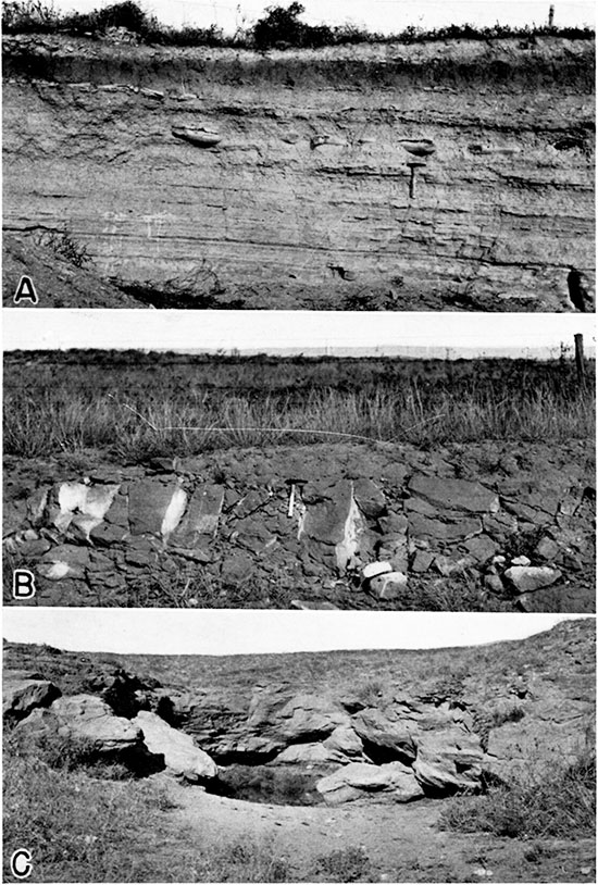
Plate 12--A, Jetmore chalk member of the Greenhorn limestone. Exposed in quarry north of Highway 154 about 5 miles northwest of Ford in the SW SW sec. 14, T. 27 S., R. 23 W. B, Exposure of the Dakota formation. Along north side of Highway 154 about 2 1/2 miles northwest of Ford in the NW sec. 30, T. 27 S., R. 22 W. C, Dakota formation exposed in the "Black Pool." Along the north side of Arkansas river about 4 miles northeast of Ford in the SE NE sec. 35, T. 27 S., R. 22 W.
The base of the Dakota is not exposed at any of the outcrops in the county so that the maximum thickness of the formation is not definitely known. A complete section of the Dakota, penetrated in test hole 19, in the southwestern part of the county, was found to be only 56 feet thick, and the Dakota is known to be even thinner in some places in the southern part of the county. In the northeastern part of the county the Dakota formation attains greater thickness, and appears to be about 235 feet thick in a well (34) at Spearville (log 25).
Age and correlation--The age and correlation of the Dakota formation are discussed under the heading Historical summary.
Water supply--The Dakota formation, known elsewhere generally as the Dakota sandstone, is an important water-bearing formation in several other states and is a notable source of artesian water. In Ford County the Dakota formation is the most important water-bearing formation below the Ogallala formation. In places where the Ogallala formation is thin and fails to produce water, as in parts of northern Ford County, the wells generally are drilled into the Dakota formation.
The Dakota formation furnishes water to flowing artesian wells in Sawlog valley in sections 13, 14, 23, and 24, T. 24 S., R. 23 W., in Hodgeman County, just north of Ford County (Moss, 1932, pp. 45-46). The wells start near the top of the Dakota and obtain the artesian water at a depth of about 200 feet. In Ford County the water in the Dakota formation generally is under some artesian head, but in most places the head is not sufficient to produce flowing wells. The Dakota is believed to supply, in part, one flowing well (520) in the southwestern part of the county. The source of several other flowing wells in this part of the county is not definitely known, but is believed to be the overlying sands and gravels of Tertiary and Pleistocene age (p. 51). The possibility of obtaining flowing wells in the Dakota in the Arkansas valley near the Edwards county line is discussed under Artesian conditions.
Many of the domestic and stock wells in the northeastern part of the county obtain water from the Dakota formation. Most of the wells range in depth from about 50 to 250 feet, but well 34, formerly used as a source of supply for the Atchison, Topeka and Santa Fe Railway at Spearville, was drilled to a depth of 389 feet (see log 25). The wells that obtain water from the Dakota formation in the southwestern part of the county range in depth from about 175 to about 275 feet. The sandstone in the Dakota is fine-grained and does not yield water as freely as either the Ogallala or the alluvium. Under favorable conditions, however, a well in the Dakota might yield as much as 250 gallons a minute (p. 120).
Five waters from the Dakota formation that were analyzed had from 239 to 464 parts per million of total dissolved solids, except for one sample, which had 4.8 parts of iron. Four of the five waters had two or more parts of fluoride.
Graneros Shale
Character--The Graneros shale, which overlies conformably the Dakota formation, consists of bluish-gray, noncalcareous clay-shale with a few thin beds of sandstone and sandy shale. It is less calcareous than the overlying Lincoln limestone member of the Greenhorn limestone. The contact at the base of the formation, however, is less distinct because generally there is a transitional zone between the Graneros and the underlying Dakota formation. In places where the sandstones in the upper part of the Dakota are massive, the contact is placed at the top of the sandstone, but in places where the upper part of the Dakota is thin-bedded and shaly the contact is recognized by a change from dark-colored argillaceous shale containing selenite crystals above to a blue sandy shale below.
The Graneros shale is generally dark bluish-gray to black in color, but it contains numerous flakes of yellow sandstone and an abundance of selenite crystals. Outcrops of the shale generally are strewn with these transparent crystals, some of which are six inches or more in length. Many thin lenses of sandy shale, sandstone, sandy limestone, and ironstone concretions are interbedded in the shale. The base of the Graneros shale commonly is marked by ferruginous concretions or thin-bedded layers of ironstone. The following section was measured on the west side of a tributary drainage to Sawlog creek in the northern part of the county (pl. 13A).
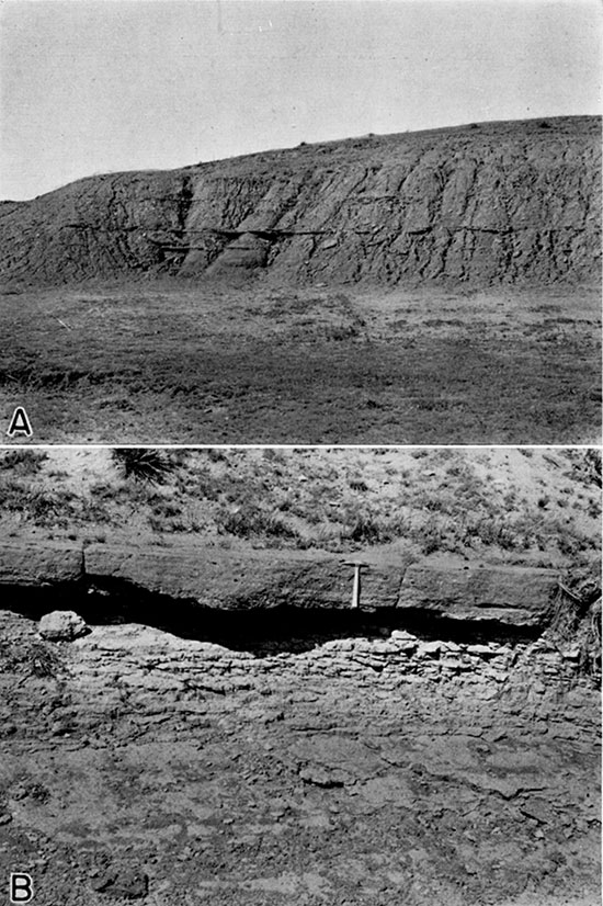
Plate 13--A, Exposure of Graneros shale. West side of tributary drainage near the middle of sec. 10, T. 25 S., R. 23 W. About 14 feet of the overlying Lincoln limestone member of the Greenhorn limestone is exposed in the grass-covered slope above the cut bank. B, Upper part of Dakota formation. Exposure is about 100 yards north of Plate 13 A, farther down the same drainage. Top ledge is cross-bedded conglomeratic sandstone and is underlain by rusty-yellow, very fine-grained sandstone.
| Section of the Graneros shale near the middle of section 10, T. 25 S., R. 28 W. | Thickness, feet |
|
|---|---|---|
| Lincoln limestone member of the Greenhorn limestone | ||
| Graneros shale | ||
| 11. Shale, clayey, fissile, bluish-gray, containing yellow to olive-green streaks and scattered chips of limonite | 3.0 | |
| 10. Shale, sandy gray, containing interlaminated stringers of olive-green fine-grained sandstone and shale | 4.5 | |
| 9. Shale, clayey, bluish-gray, similar to bed 11, but containing also thin beds of gray platy sandstone | 5.5 | |
| 8. Shale, fissile, gray to black, containing a lentil of rusty brown sandstone at the top and thin interstratified stringers of olive-green to gray to brown shaly sandstone | 7.5 | |
| 7. Shale, papery fissile, gray to black, containing considerable gypsum, some interlaminated shaly sandstone, and near the top, limonitic shaly sandstone | 5.5 | |
| 6. Shale, similar to bed 8, but containing a few thin seams of selenite near the base | 2.0 | |
| 5. Sandstone, hard, reddish-brown, limonitic, thin-bedded. Forms slight ledge in face of exposure | 0.5 | |
| 4. Shale, fissile, gray to black, containing interlaminated stringers of sandstone and scattered thin seams of selenite crystals | 2.5 | |
| 3. Shale, fissile, gray-black, containing selenite crystals | 5.7 | |
| 2. Shale, sandy, gray to black, containing large angular clusters of selenite crystals, some 5 to 6 inches in length, and, near the base, stringers of grayish-brown shaly sandstone | 2.0 | |
| 1. Shale, sandy, dark gray, containing 3 or 4 beds of ironstone concretions averaging 3 inches thick at base | 4.0 | |
| Total thickness of Graneros shale exposed | 42.7 | |
Distribution and thickness--The Graneros shale is exposed along Sawlog Creek and several of its tributaries in the northern part of Ford County, notably in the northeastern part of T. 25 S., R. 24 W., and in the northwestern part of T. 25 S., R. 23 W. It generally forms a slope between ledges of the Greenhorn limestone and the Dakota formation. Approximately 17 feet of the Graneros is exposed on the south side of Sawlog Creek in the NE sec. 9, T. 25 S., R. 24 W., but west of this point it passes under cover and only the basal members of the Greenhorn limestone are exposed. In some parts of the county the Graneros is very thin, and it is absent entirely in the Hain quarry, in the SW sec. 10, T. 26 S., R. 22 W., where the Ogallala formation rests directly on the Dakota formation, and in exposures about 2 1/2 miles northwest of Ford and on the north side of the Arkansas River east of Ford. A thin remnant of the Graneros is exposed in the slope between the Dakota formation and the overlying Ogallala formation on the east side of Five-Mile Creek in the NW NW sec. 30, T. 25 S., R. 23 W. The Graneros shale was encountered in test holes 1, 2, 5, and 8 (fig. 2) and in many wells in the northern and central parts of the county.
The thickness of the Graneros in Ford County ranges from a few feet to about 43 feet, and was 21 to 39 feet thick in four of the test holes (1, 2, 5, and 5). According to Moss (1932, p. 31), the Graneros in Ness and Hodgeman counties ranges in thickness from about 21 to 36 feet. He suggests that the variable thickness of the Graneros probably is due to its having been deposited on the slightly irregular surface of the underlying Dakota formation, and that this irregular surface may have resulted from uneven deposition, erosion of the top of the sandstone, or from compaction within the Dakota formation. According to Bass (1926, p. 36), the Graneros is about 32 feet thick in Ellis county, 40 feet in Russell county, and 61 feet in western Kearny and Hamilton counties.
Age and correlation--Although no fossils were noted in the drill cuttings the Graneros shale was readily identified in test holes by the argillaceous, noncalcareous character of the black shales that comprise the formation, and by the stratigraphic position of these shales above the Dakota formation. The cuttings from the Graneros comprise rubbery chips of soft, sticky, black clay-shale containing a few chips of gypsum and bentonite. The cuttings differ from those obtained from the overlying slabby limestones and chalky shales of the Greenhorn limestone and are less sandy and darker-colored than those from the underlying blue shales of the Dakota formation.
Water supply--No wells are known to derive water supplies from the Graneros shale in Ford County. Because of the relatively low permeability of most of the formation, the quantity of water contained in the shale and interbedded stringers of sandstone doubtless would be small, and movement of water through the formation would he confined largely to bedding planes and fissures. Because of the abundance of gypsum throughout the formation, any water contained in it is likely to be highly mineralized and very bitter to the taste.
Greenhorn Limestone
Character--The Greenhorn limestone consists of a lower series of thin chalky and crystalline limestone and bentonitic clay and an upper series of interbedded chalky shales and chalky limestones capped by the "Fence-post" limestone. The shales in the upper part of the formation contain several zones of limestone concretions (pl. 12A). On fresh exposure the limestones and shales are dull gray in color and the bentonitic clays are light pearly gray. Upon weathering, however, the color of the limestones changes to tan, buff, or orange-tan, and the shales weather tan or light gray in the upper part and tan or orange-tan in the lower part. The basal part of the Greenhorn weathers to a distinctive rusty-brown or orange color.
Previous workers in western Kansas (Rubey and Bass, 1925, p. 45) have subdivided the Greenhorn into four members which from top to bottom are the Pfeifer shale, Jetmore chalk, Hartland shale, and Lincoln limestone. In Ford County the upper two members are easily recognized, but it is difficult to distinguish between the lower two members.
The Pfeifer shale member consists of beds of cream-colored to yellow chalky shale, some beds of thin chalky limestone, and some concretions of limestone (p1. 14C). The "Fencepost" limestone at the top of the member is resistant to erosion and generally forms a ledge.
The Jetmore chalk member, which underlies the Pfeifer shale member, consists of about 23 feet of interbedded chalky shale and chalky limestone. The beds of chalky limestone in this member are harder than those of the overlying Pfeifer member and form the most resistant part of the Greenhorn. The Jetmore member is capped by a hard, fossiliferous, chalky bed of limestone approximately one foot thick, and because it is very resistant and contains an abundance of the Pelecypod Inoceramus labiatus it has been called "shell rock." The shell rock breaks into large slabs, which cover the slopes below.
The Hartland shale member consists of beds of calcareous shale, thin beds of chalky limestone, and generally weathers light tan or gray. The Lincoln limestone member, which underlies the Hartland member, consists of beds of chalky shale alternating with thin beds of chalky limestone, and, near the base, beds of hard, thin-bedded, finely-banded, dark-colored limestone (pl. 14). When freshly broken, the beds of dark-colored limestone near the base of the Lincoln member have an odor resembling petroleum.
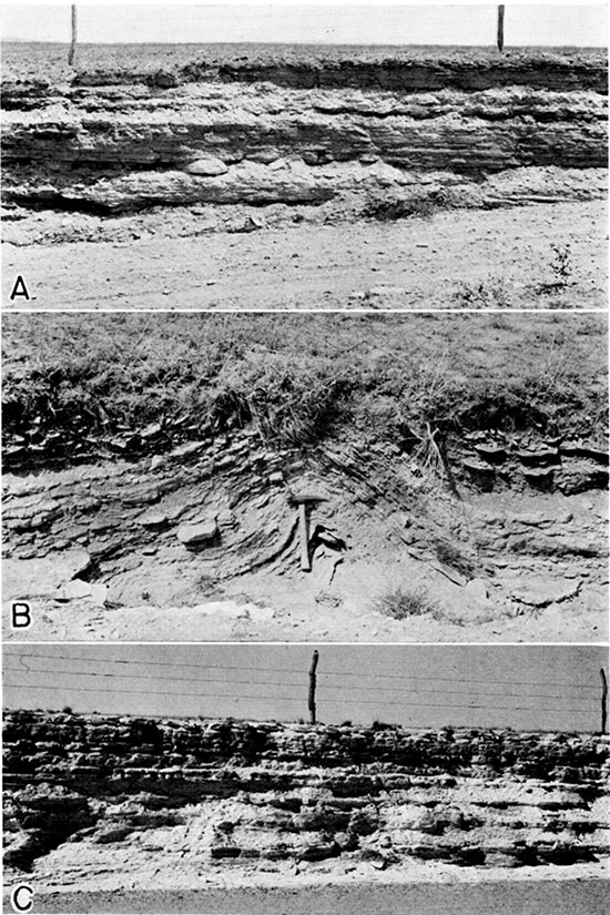
Plate 14--A, A part of the Lincoln limestone member of the Greenhorn limestone. In road cut 0.45 miles north of the Ford-Hodgeman county line, on the west line of the NW SW sec. 35, T. 24 S., R. 23 W. B, Small fold in the Lincoln limestone member of the Greenhorn limestone. In road ditch on the east line of the SE NE sec. 3, T. 25 S., R. 23 W. C, A part of the Pfeifer shale member of the Greenhorn limestone. In road cut on the south side of section road in the NW NE sec. 17, T. 25 S., R. 25 W.
The four members of the Greenhorn are not all exposed at any one place in Ford County, therefore sections measured at several different places were correlated in order to obtain the total thickness of the formation. The following section, at a point about eight miles northwest of Dodge City, gives the character of the lower part of the Pfeifer shale member and the complete Jetmore chalk member.
| Section of the Pfeifer shale and Jetmore chalk members of the Greenhorn limestone, in a quarry in the SE SW sec. 11, T. 25 S., R. 25 W. | Thickness, feet |
||
| Ogallala formation | |||
| Greenhorn limestone | |||
| Pfeifer shale member | |||
| 29. Limestone, chalky, containing a ferruginous band near the middle, resembling casts of inoceramus replaced by limonite, very fossiliferous, weathers yellow to brown | 0.5 | ||
| 28. Shale, limy, white to cream-colored, very fossiliferous | 1.7 | ||
| 27. Limestone, chalky, hard, tan to white, contains abundant fossils; similar to No. 25 | 0.7 | ||
| 26. Shale, chalky, white to cream-colored | 0.4 | ||
| 25. Limestone, chalky, tan to cream-colored, fossiliferous - contains abundant inoceramus labiatus (represents the upper or main quarry level | 6.0 | ||
| 24. Shale, chalky, white | 0.5 | ||
| Total thickness of Pfeifer shale member exposed | 9.8 | ||
| Jetmore chalk member | |||
| 23. Limestone, hard, chalky, white to cream-colored, has tendency to break off in flat blocks | 1.1 | ||
| 22. Shale, chalky, white | 0.9 | ||
| 21. Limestone, relatively hard, chalky, tan to cream-colored, and interbedded chalk shale | 2.6 | ||
| 20. Shale, chalky, gray, very fossiliferous, grades laterally into slabby thin-bedded limestone, weathers light yellow to tan | 1.0 | ||
| 19. Limestone, chalky, white to cream-colored, fossiliferous | 0.5 | ||
| 18. Shale, chalky, white to gray, grades into bed 19 | 1.3 | ||
| 17. Limestone, chalky, white to gray, stained with limonite | 0.7 | ||
| 16. Limestone, chalky, dark bluish-gray on fresh exposure, platy in upper part, breaks off in large flat-sided slabs | 1.8 | ||
| 15. Shale, chalky, bluish-gray on fresh exposure | 1.5 | ||
| 14. Limestone, chalky, white, weathers into platy slabs | 0.9 | ||
| 13. Shale, chalky, bluish-gray on fresh exposure | 0.7 | ||
| 12. Limestone, chalky, white | 0.3 | ||
| 11. Shale, chalky, bluish gray on fresh exposure, somewhat fissile; similar to bed 13 | 0.6 | ||
| 10. Limestone, chalky, white, has tendency to weather into platy slabs | 0.9 | ||
| 9. Shale, chalky, yellow to tan | 0.5 | ||
| 8. Shale, chalky, bluish-gray on fresh exposure, fossiliferous - containing abundant inoceramus labiatus, breaks off in plates resembling slate | 2.7 | ||
| 7. Shale, chalky, yellow to buff, fossiliferous | 0.4 | ||
| 6. Limestone, hard, yellow to white, streaked with brown stains of limonite | 0.5 | ||
| 5. Shale, chalky, yellow to buff, fossiliferous, banded with seams of limonite, weathers tan to flesh-colored, similar to beds 7 and 9 | 1.1 | ||
| 4. Limestone, chalky, white, weathers yellow to buff | 0.2 | ||
| 3. Shale, chalky, yellow, weathers buff to flesh-colored | 1.0 | ||
| 2. Limestone, chalky, gray to white, weathers yellow to tan | 0.6 | ||
| 1. Shale, chalky, buff to tan, weathers flesh-colored, contains inoceramus labiatus | 1.0 | ||
| Total thickness of Jetmore chalk member | 22.8 | ||
In the above section the base of the Jetmore member is not sharply defined, the chalky limestone beds in the lower part of the Jetmore becoming thinner and less numerous and grading into the calcareous shale of the underlying Hartland shale member.
Some of the beds of limestone in the Greenhorn have been quarried extensively and used for fence posts, flagging, and building stone. The "Fencepost" limestone is used chiefly for fence posts but has also been used for building road culverts, bridges and other works. It is remarkably persistent and very uniform in thickness--which ranges from about 7 to 9 inches. It is usually soft when quarried but case-hardens on exposure.
The Jetmore chalk member is quarried in the SW SW sec. 14, T. 27 S., R. 23 W. (pl. 12A), and a 5-inch bed of chalky limestone about 20 feet below the base of the Jetmore member has been quarried for building stone.
Distribution and thickness--The Greenhorn limestone is exposed along Sawlog Creek and several of its tributaries in northern Ford County. Outcrops of the upper part of the formation extend west along Sawlog Creek to within about 7 miles of the northwest corner of the county where it is overlapped by the Ogallala formation. The lower part of the formation is well exposed along Duck creek, the outcrop area extending southwest along the creek to a point about 5 miles north of Dodge City, and along Sawlog Creek and its tributaries from a point, about due north of Dodge City to the point where Sawlog Creek leaves the county, 3 miles east of U.S. Highway 283. Exposures of the upper part of the formation occur in the heads of tributaries to Coon Creek, about 2 1/2 miles northeast of Wright in sections 2, 10, and 11, T. 26 S., R. 23 W., and in the bluffs on the north side of the Arkansas valley in sections 14, 15, 23 and 24. A part of the Lincoln member is well exposed in a road cut about one-half mile north of the Ford-Hodgeman County line, on the west line of the NW SW sec. 35, T. 24 S., R. 23 W. (pl. 14A).
It is known from test drilling that the Greenhorn limestone underlies much of the northern part of the county and a large area in the southern part of the county on the uplands between Mulberry Creek and the Arkansas valley. Thin remnants of the Greenhorn were encountered above the Graneros shale in some of the test holes in the Arkansas valley, but the Greenhorn is believed to be entirely absent in the Arkansas valley east of Ford. The Greenhorn was encountered in 10 of the 21 test holes put down in the county (fig. 2) but was not encountered in test holes 4 and 5 in the northern part of the county, 8 in the Arkansas valley, 19, 20, and 21 in the southwestern corner of the county, and in test holes 10, 14, 15, 16 and 17 in the southern and southeastern part of the county. Thus, the Greenhorn appears to have been removed by erosion in a large area south of Mulberry Creek and east of U.S. Highway 283, including the entire area south of Arkansas River and east of Ford.
The thickness of the Greenhorn limestone in Ford County is about 123 feet, but the entire thickness is not exposed at any one place. The total thickness of the Pfeifer shale member is not definitely known, but is believed to be about 20 feet, as it is in western Hodgeman County (Moss, 1932, p. 28). The Jetmore chalk member is about 23 feet thick, and the Hartland and Lincoln members have an aggregate thickness of 80 feet in sec. 5, T. 25 S., R. 24 W.
Age and correlation--Where the Greenhorn limestone is exposed at the surface in Ford County, the identification of the individual members on the basis of their lithology and stratigraphic position is relatively simple. At the base of the formation there is a sharp lithologic break between the thin beds of hard crystalline limestone at the base of the Lincoln member and the underlying beds of soft, noncalcareous clay shale of the Graneros shale. The top of the formation is marked by the top of the "Fencepost" limestone.
Practically all of the beds of the Greenhorn limestone contain Upper Cretaceous fossils, the most abundant and characteristic fossil being inoceramus labiatus. The overlying Fairport chalky shale member of the Carlile shale (not present in Ford County) contains a few specimens of this pelecypod, but none are found below the Greenhorn.
Exposures of the Greenhorn in Ford County are correlative with similar exposures in Ness and Hodgeman counties, described by Moss (1932, pp. 26-31). Along the Arkansas valley in Kearny and Hamilton counties, beds equivalent to the Pfeifer and Jetmore members in Ford and Hodgeman counties have been included in the Bridge Creek limestone member of the Greenhorn (Bass, 1924, pp. 34, 35). There the Bridge Creek member is 74 feet thick and is underlain by the Hartland and Lincoln members.
In areas where the Greenhorn is buried it is possible to segregate the upper part of the Greenhorn from the lower part by a study of the drill cuttings from test holes, but it is difficult to differentiate between the 4 separate members. In Ford County the Greenhorn is the youngest Cretaceous formation; hence, there is no confusion with the overlying Fairport chalky shale member of the Carlile shale which is similar in character. The base of the Greenhorn limestone is readily identified from drill cuttings by a change from the chips of calcareous shale and limestone of the basal part of the Greenhorn to the chips of noncalcareous, softer and darker clay-shale of the Graneros shale.
Water supply--Very few wells have been drilled into the Greenhorn limestone for water supply in Ford County. It is likely that the water-yielding capacity of the formation is low, and very small supplies of comparatively hard water may be expected from wells penetrating this formation. The hardness of the three samples of water (wells 55, 352, and 353, in table 14) from the Greenhorn ranged from 358 to 546 parts per million.
Prev Page--Quality || Next Page--Tertiary and Quaternary
Kansas Geological Survey, Ford County Geohydrology
Web version April 2002. Original publication date Dec. 1942.
Comments to webadmin@kgs.ku.edu
The URL for this page is http://www.kgs.ku.edu/General/Geology/Ford/06_form.html