![]()
Prev Page--Table of Contents || Next Page--Geography
Introduction
Purpose and scope of the investigation
The investigation upon which this report is based is part of an extended program of groundwater investigations in Kansas begun in July, 1937, by the United States Geological Survey and the State Geological Survey of Kansas in cooperation with the Division of Sanitation of the Kansas State Board of Health and the Division of Water Resources of the Kansas State Board of Agriculture. Similar investigations are being conducted in several other counties in southwestern Kansas. It is expected that additional areas will be selected for study in order to determine groundwater conditions in critical parts of the state.
As a result of several years of recurrent drought, numerous inquiries were received by the state geologist in regard to the possibilities of utilizing ground water for irrigation in parts of southwestern Kansas. As a result of these inquiries S.W. Lohman made a brief investigation in Ford County in November, 1937, in order to determine the nature and extent of recent developments of water supplies from wells available for irrigation in the uplands of that county, and to determine what additional studies should be made in the future. The recommendations made at that time (Lohman, 1938, p. 9) are in part as follows:
"A general investigation of groundwater conditions should be made that will cover not only Ford County, but also as much of the territory adjoining as is necessary to make an adequate interpretation of the geologic and hydrologic conditions in each locality as to occurrence, depth, and yield of the water-bearing beds and the depth to the static water level, and to determine so far as possible the safe yield of the water-bearing formation.
"A program of water-level measurements should be begun immediately to obtain observations before there is any significant change from natural conditions undisturbed by pumping for irrigation. The measurements should be continued in subsequent years and records should be obtained of the quantities of ground water that are pumped each month or year, in order to determine the trends in movement of water level resulting from irrigation and to check preliminary conclusions as to the safe yield of the water-bearing formations. There is at present so little use of ground water for irrigation in Ford County and the adjacent territory that an unusual opportunity is offered to determine hydrologic conditions as unaffected by artificial withdrawal.
"A study should also be made of the chemical character of the water in regard to its suitability for irrigation.
"Studies should be made to determine the most economical type of well construction for a given locality or given type of material - especially to determine whether in certain areas irrigation wells can be constructed without artificial gravel packing."
In accordance with the above recommendations, I was assigned to the area in October, 1938. Shortly after the work began, an interagency conference was held in Dodge City in order to coordinate the efforts of federal and state agencies that are concerned with problems relating to the water resources of western Kansas. The scope of the Ford County investigation was temporarily altered to include only a comprehensive inventory of pumpage from wells in the Arkansas valley part of the county. The results of this preliminary survey were included in a brief report and released to the public in a memorandum for the press (Waite, 1939, pp. 1-2). A detailed survey of the entire county was completed in 1939.
The investigation was made under the general administration of R.C. Moore and K.K. Landes, state geologists, and O.E. Meinzer, geologist in charge of the Division of Ground Water of the Federal Geological Survey, and under the immediate supervision of S.W. Lohman, federal geologist in charge of groundwater investigations in Kansas.
Location and extent of the area
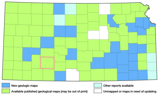
Ford County lies in southwestern Kansas and embraces a total of 30 townships, or 1,082 square miles. Its location with respect to adjoining counties is shown by figure 1.
Figure 1--Index map of Kansas showing area described in this report and areas covered by other geologic maps, as of Feb. 2002. For additional information, the KGS Geologic Maps of Kansas Page.
Previous investigations
The more important studies dealing with the geology and groundwater resources of southwestern Kansas that have a bearing on Ford County are cited below. Specific references are cited at appropriate places in the text by author and date of issue and are listed in the bibliography at the end of the report.
In 1892, Colonel Nettleton (1892, pp. 27-32, appendix No. 11) reported on the results of some underflow surveys along the Platte and Arkansas River valleys including a discussion and plat of a north-south profile of the water table extending across Ford County and passing through Dodge City. In 1897, Sutton (1897, pp. 40-41) published the log of a well drilled for experimental use at a pumping station in Ford County. In this same report, Haworth (1897a, 49-114) reported on the geology of underground water in western Kansas. Three other papers were contributed by Haworth in 1897, one (1897b) on underground waters of southwestern Kansas, another (1897c) on the physiography of western Kansas, and a third (1897d) on the physical properties of the Tertiary rocks in Kansas. Johnson's scholarly paper on the "Utilization of the High Plains" (1901) dealt with the physiography, underground waters and the land economy of the High Plains. A second paper (Johnson, 1902) containing conclusions and a summary of the first paper appeared in 1902. In 1905, Darton (1905, p. 298) published a preliminary report on the geology and groundwater resources of the central Great Plains, in which he made brief reference to Ford County. In 1906 a report by Slichter (1906) was published on the results of some underflow experiments and related studies on underground water along the Arkansas valley, and although the locale of this work was considerably west of Ford County, his findings have a direct bearing on conditions in parts of the county. In 1911 a very brief description of the availability of ground water in Ford County was given by Parker (1911, pp. 91-94, 269-273) along with the analyses of some typical well waters collected near Dodge City. In 1912 a report by Coffey and Rice (1912) was published that contained the results of a reconnaissance soil survey of the western half of Kansas, including Ford County. In 1913, Haworth (1913) contributed a report on well waters in southwestern Kansas. In 1916 Darton (1916, pp. 35-41, sheets 5 and 6) described the geology along the route of the Atchison, Topeka and Santa Fe Railway. In 1918, Darton (1918, pp. 5-8) described briefly the structure of parts of the central Great Plains, taken in part from several of his earlier reports. In 1931 the Division of Water Resources of the Kansas State Board of Agriculture published a report (1931) that contained a description of some of the most common types of pumping plants in Kansas with approximate costs of construction. In 1935, Theis, Burleigh, and Waite (1935) described briefly the water-bearing formations and the availability of ground water in the southern High Plains. In 1937, Lohman (1937) contributed a short paper on water supplies from wells available for irrigation in the uplands of Ford County, and included the conclusions and recommendations that led to the present investigation. In 1937, Smith (1937, pp. 283-291) contributed some preliminary notes on Pleistocene gravels in southwestern Kansas with particular emphasis on their distribution along the Arkansas valley. In 1937, a report by Throckmorton and others (1937, pp. 69-71) was published on the agricultural resources of Kansas which included important statistical data for Ford County. In 1938 the Division of Water Resources of the Kansas State Board of Agriculture published a report (1938) containing the results of tests of deep-well pumping plants with special attention to fuel consumption. Two of the plants that were tested are located in Ford County. In 1939 Davison (1939) contributed a report on the construction and costs of irrigation pumping plants in Kansas, containing a description of different types of pumping plants, the conditions for which each is best adapted, construction methods, and a discussion of construction costs. Also in 1939, McCall and Davison (1939) contributed a report on the cost of pumping for irrigation that includes data on several tests of irrigation pumping plants in Ford County. In 1939, a report was published (Meinzer and Wenzel, 1939, pp. 93-100) on water levels and artesian pressures in the United States in 1938; it contains a chapter on the observation-well program in Ford County. In 1939, I (Waite, 1939) prepared a brief preliminary report on the groundwater resources of the Arkansas valley in Ford County. In 1940, Moore (1940) prepared a generalized report on the groundwater resources of Kansas which includes a section on Ford County. A report by Smith (1940) entitled "Geologic Studies in Southwestern Kansas," includes many references to the geology of Ford County.
Methods of investigation
The field work upon which this report is based occupied about 2 1/2 months in the fall of 1938 and about 5 months in the summer of 1939. Approximately 530 wells in the county were visited and the total depth and depth to water level below land surface in most of them were measured with a steel tape. Well owners and drillers were interviewed regarding the nature and thickness of the water-bearing formations penetrated by the wells, and all available logs were collected. Records were collected of wells that furnish public, industrial, domestic, and irrigation supplies. Information was obtained regarding the yield, drawdown, temperature of water, chemical character of the water, and the use of ground water.
Samples of water were collected from 65 representative wells and 1 spring and were analyzed by Robert H. Hess, chemist, in the Water and Sewage Laboratory of the Kansas State Board of Health at Lawrence. In addition analyses of water from the 3 public supplies in the county, together with an analysis of water from a well of the Kansas Power Company in Dodge City, were furnished by the Kansas State Board of Health, making a total of 70 analyses for Ford County.
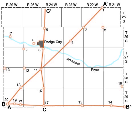
During the investigation 21 test holes (fig. 2) were put down at strategic points in Ford County by Ellis Gordon, Perry McNally, and Fred Holden with a portable hydraulic-rotary rig owned by the State and Federal Geological Surveys. Laurence Buck replaced Fred Holden near the end of the drilling program. Samples of drill cuttings were collected and studied in the field by Perry McNally end were examined later in the office under binocular microscone. Additional logs and drill cuttings were made available by W.R. Stanley and Lewis H. Bacon, of the Soil Conservation Service at Dodge City, and materially aided in the interpretation of subsurface conditions. A rather comprehensive test-drilling program was conducted by this organization in parts of the Arkansas valley, including Ford County.
Figure 2--Map of Ford County showing locations of test holes and locations of cross sections shown on plate 5.
Altitudes of the measuring points were established with plane table and telescopic alidade at 368 wells and at the portals of each of the test holes put down by the drilling rig. The levels were run from benchmarks of the United States Coast and Geodetic Survey by Delmar O. Branson, assisted by Everett Johnson and in part by Charles C. Williams. The water-table contour map (pl. 1) is based upon these altitudes together with the measured depths to water level in wells.
Field data were compiled on topographic maps of the U.S. Geological Survey and on an ownership map of Ford County. The base map for plates 1 and 2 was prepared from a county map compiled by the State Highway Department. The locations of the roads were corrected from observations in the field and the drainage was corrected from aerial photographs obtained from the United States Department of Agriculture, Agricultural Adjustment Administration.
The areal geology shown in plate 1 was compiled from field studies supplemented by liberal use of the aerial photographs and by available geologic reports. Many of the boundaries of the areas of alluvium and dune-sand were taken from aerial photographs supplemented by observations in the field.
The locations of all wells for which descriptions are given in the tables of well records are shown in plate 2, with the exception of an area several square miles in extent in and adjacent to Dodge City. On account of the concentration of irrigation wells in this local area, a larger-scale map has been prepared (plate 3) showing the locations of each of the wells that were visited. Two numbers are shown opposite each well symbol, the upper one corresponding with that used in the well tables in the text, and the lower one corresponding with the depth to water level below the land surface.
The wells are numbered consecutively by townships from north to south and by ranges from east to west. Within each township the wells are numbered in the same order as the sections. Within each section the wells are numbered in the sequence of the sixteen 40-acre tracts into which sections are divided by the General Land Office, as shown in the explanation of plate 2.
Acknowledgments
I am indebted to the many residents of the county who readily gave permission to measure their wells, and who supplied helpful information regarding them. Special acknowledgment should be given to the fine cooperation of all the well drillers in the county for making available to the writer well logs and in some cases samples of water-bearing materials. George S. Knapp, chief engineer of the Division of Water Resources, Kansas State Board of Agriculture, made available unpublished data relating to wells, and assigned Kenneth D. McCall and Milburn H. Davison to conduct pumping tests on several typical irrigation wells in Ford County. I spent several days in the field with McCall and Davison, assisting them with the pumping tests. Thanks are due to Harold T.U. Smith, of the Department of Geology, University of Kansas, for unpublished data and for helpful suggestions in the preparation of this report. Thanks are due also to Claude W. Hibbard, assistant curator of vertebrate paleontology of the Dyche Museum of Natural History, University of Kansas, for close cooperation in the field and for helpful identification of vertebrate and invertebrate material collected in Ford County. Several days were spent in the field with Smith and Hibbard studying stratigraphic relations in Ford County and adjacent areas. Special acknowledgment is due to Fred Moon, irrigation specialist, of the Kansas Power Company, Dodge City, for valuable assistance during the entire investigation.
Acknowledgment for helpful information is due also to the following persons: J.C. Denious and Jay Baugh, Dodge City Daily Globe; Frank Dunkley, secretary of the Dodge City Chamber of Commerce, and C.C. Isely, chairman of the Special Irrigation Committee of that organization; P.H. Browne, Johnston Pump Company, Dodge City; Fred Kirkpatrick, city engineer; Glenn Faulkner county engineer; Rex Reynolds, city water commissioner; A.M. Truman, division engineer, and Dave Kriegh, draftsman, both of the Atchison, Topeka and Santa Fe Railway, Dodge City; H.I. Christensen, Norvall White, Frank White, and Frank Westerman of the Kansas Power Company's plant near Fort Dodge; F.E. Vance, engineer in charge of the power plant at the Kansas Soldiers' Home at Fort Dodge; U.G. Balderston, Dodge City; Tom Stauth, Dodge City; J.E. Homnan, Kansas Power Company, Dodge City; John Dortch, water superintendent of Spearville, Kan.; and J.F. Devore, city clerk of Bucklin.
Logs of test wells put down by the Layne-Western Company at Dodge City and at Minneola Booster Station No. 3 of the Natural Gas Pipe Line Company of America were kindly furnished by R.O. Joslyn, president of that company.
The manuscript for this report has been critically reviewed by S.W. Lohman, O.E. Meinzer, and W.D. Collins of the Federal Geological Survey; H.C. Moore and J.C. Frye of the State Geological Survey; George S. Knapp, chief engineer of the Division of Water Resources of the Kansas State Board of Agriculture; and Lewis Young, acting director of the Division of Sanitation of the Kansas State Board of Health. The illustrations were drafted by G.W. Reimer, Alice Bruce, Dorothea Weingartner, Joan Justice, and Eva Baysinger, of the Kansas Geological Survey.
Prev Page--Table of Contents || Next Page--Geography
Kansas Geological Survey, Ford County Geohydrology
Web version April 2002. Original publication date Dec. 1942.
Comments to webadmin@kgs.ku.edu
The URL for this page is http://www.kgs.ku.edu/General/Geology/Ford/02_intro.html