


|


|
Region: Northern Midcontinent
System: Mississippian
Upper Mississippian--Province Summary
This Upper Mississippian Play information is from the
U. S. Geological Survey
1995 National Assessment of United States Oil and Gas Resources (available
on CD-ROM from the U.S.G.S. as Digital Data Series DDS-30, Release 2).
|
Upper Mississippian Stratigraphic Gas and Oil Play
by Mitchell E. Henry and Timothy C. Hester
Like the Lower Mississippian Stratigraphic Gas and Oil Play, this play
extends throughout the province except in the extreme southern,
southwestern, and northeastern parts where Mississippian age strata are
missing. The strata in this play consists of the St. Louis Formation
and all Mississippian Chester Group rocks, except those strata included
in Deep Stratigraphic Gas Play. Depths range from about 4,000 ft on the
northeastern shelf to 13,000 ft at the southern play boundary (the upper
depth limit of the Deep Stratigraphic Gas Play). Some individual units
in the included strata appear to be absent along the eastern and
northeastern part of the play, probably due to subareal erosion and
ultimate truncation along the Nemaha and Central Kansas Uplifts, and the
Pratt Anticline. The stratigraphic units included in this were selected
largely on the basis of the distribution of major accumulations and on
lithology. The major accumulations in this play generally occur in the
central and north-central parts of the basin, away from significant
influence of major province-bounding uplifts. The play is viewed as
principally stratigraphic but with some local structural influence. The
distribution of major accumulations and a carbonate lithology are the
principal defining features of this play.
Reservoirs
Reservoirs rocks consist of the St. Louis Formation and the Chester
Group. Lithologies are almost exclusively limestone on the shelf areas,
although Chester Group rocks become increasingly shaly to the southeast,
and sandstones become more common in the deep basin. Chester Group
rocks range in thickness from erosional truncation in the northeastern
and southwestern parts of the province to 1,000 ft in the southern part
of the province at the boundary of Deep Stratigraphic Gas Play. The
upper surface of rocks in the Chesterian Series has undergone extensive
weathering and erosion in much of the play (Northcutt and Parham, 1993),
and in those areas reservoir quality is expected to be good. In deeper
parts of the play and in lower parts of the section, reservoir quality
is expected to be more variable and poorer overall. Oil and gas
production is generally concentrated in areas of the unconformity
surfaces--a band trending east-west across the central part of the
province. This pattern of reservoir development, although resulting
predominately from uplift and subareal erosion, shows little dependence
on proximity to the major structural features that bound the province.
Stratigraphic trapping mechanisms dominate in this play, with only local
structural influence.
Source rocks
Rice and others (1989) identified interbedded shales as the most likely
source for central basin gas accumulations found in Upper Mississippian
sandstone reservoirs. Organic carbon content (TOC) of shales of the
Upper Mississippian Springer Formation ranges from 0.5 to 3.4 percent.
Variability in chemical and isotopic composition, however, suggests some
mixing of hydrocarbons from other sources. Although it seems reasonable
to assume that the gas produced from carbonate rock and sandstone
reservoirs in the same (or adjacent) play could have the same source,
the organic matter (type III) described by Rice and others (1989) is not
a likely source for the oil found in this play. Type III kerogen is
highly gas prone. A probable source for the oil, and perhaps some of
the gas as well, is the Woodford Shale. Woodford Shale source-rock
properties are described in detail in Hester and others (1990).
Timing and migration
On the basis of the late-stage generation of gas suggested by Rice and
others (1989) and burial history modeling by Schmoker (1989) we estimate
that much of the gas in this play was probably generated between 225 and
100 Ma. Since much of the production from this play is from
stratigraphically controlled reservoirs developed largely from subareal
exposure, reservoirs and traps were in place before hydrocarbon
generation began. Timing of hydrocarbon generation and migration is
therefore favorable for charging of reservoirs in this play.
Traps
Traps for this play are mostly stratigraphic, with some combination and
minor structural types. Traps are generally sealed by shales deposited
over eroded carbonate strata or over ooid sand bars ( Ball, 1967;
Asquith, 1984 ) at or near the top of the Mississippian carbonates. The
shales range in age from Chesterian through Pennsylvanian, Morrowan,
Atokan, and Desmoinesian (Northcutt and Parham, 1993). Major
accumulations occur at depths from 4,000 to 10,000 ft.
Exploration status and resource potential
The earliest major discovery assigned to this play was made in 1921 at
the Webb field. The largest gas accumulation is at Mocane-Laverne with
an estimated ultimate recovery of about 1.2 TCFG. The largest oil
accumulation is estimated to produce about 44 MMBO from the Big Bow
field. Of the 99 accumulations assigned to this play, 40 are oil and 59
are gas. Drilling depths for this play range from about 4,200 ft in the
northern part of the play to 13,000 ft at the southern play boundary
(the upper depth limit of Deep Stratigraphic Gas Play).
More than 23,000 wells are reported to have penetrated rocks of this
play. Of these, nearly 5,000 were completed as producing wells. This
play is the most thoroughly and most uniformly explored play yet
discussed. There are still some areas that are not so well explored,
for example along the northern and northeastern parts of the play, but
they are historically poor producers. Because stratigraphic traps are
so prevalent in this play, and because stratigraphic traps are
relatively difficult to target, we expect that there are still new
accumulations to be discovered. The potential for new major hydrocarbon
discoveries in this play is moderate. Historical production and well
completion data were used to evaluate the potential of this play.
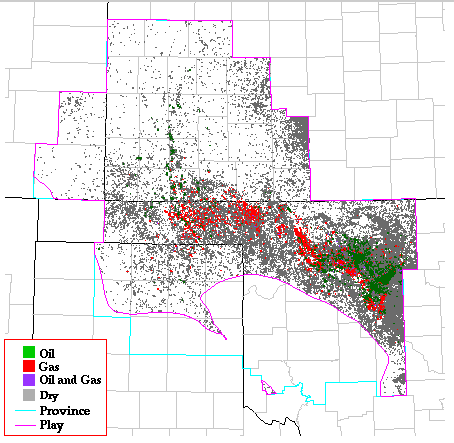
Play Map
References
Asquith, G.B., 1984, Depositional and diagenetic history of the Upper
Chester (Mississippian) oolitic reservoirs, north-central Beaver County,
Oklahoma, in Hyne, N.J., ed., Limestones of the Mid-Continent: Tulsa
Geological Society Special Publication no. 2, p. 87-92.
Ball, M.M., 1967, Carbonate sand bodies of Florida and the Bahamas:
Journal of Sedimentary Petrology, v. 37, p. 556-591.
Hester, T.C., Schmoker, J.W., and Sahl, H.L., 1990, Log-derived regional
source-rock characteristics of the Woodford Shale, Anadarko basin,
Oklahoma: U.S. Geological Survey Bulletin 1866-D, 64 p.
Northcutt, R.A., and Parham, K.D., 1993, Upper Chester shallow-marine
carbonate--Anadarko basin and Hugoton Embayment, Kansas, in Debout,
D.G., White, W.A., Hentz, T.F., and Grasmick, M.K., Atlas of major
Midcontinent gas reservoirs: p. 64-66.
Rice, D.D., Threlkeld, C.N., and Vuletich, A.K., 1989, Characterization
and origin of natural gasses of the Anadarko basin, in Johnson, K.S.,
ed., Anadarko Basin Symposium, 1988: Oklahoma Geological Survey
Circular 90, p. 47-52.
Schmoker, J.W., 1989, Thermal maturity of the Anadarko basin, in
Johnson, K.S., ed., Anadarko Basin Symposium, 1988: Oklahoma Geological
Survey Circular 90, p. 25-31.
Kansas Geological Survey, Digital Petroleum Atlas
Updated July 16, 1996
Comments to webadmin@kgs.ku.edu
URL=http://www.kgs.ku.edu/DPA/frontEnd/Anadarko/UpMiss/provSum.html