


|


|
Region: Northern Midcontinent
System: Mississippian
Lower Mississippian--Province Summary
This Lower Mississippian Play information is from the
U. S. Geological Survey
1995 National Assessment of United States Oil and Gas Resources (available
on CD-ROM from the U.S.G.S. as Digital Data Series DDS-30, Release 2).
|
Lower Mississippian Stratigraphic Oil and Gas Play
by Mitchell E. Henry and Timothy C. Hester
This play extends throughout the province, with the exception of the
extreme southern and southwestern parts where Mississippian age strata
are missing. The play consists of all Kinderhookian, Osagian, and
Meremecian age strata except the St. Louis Formation and those parts
included in the Deep Stratigraphic Gas Play. Depths range from about
4,000 ft on the northeastern shelf to 13,000 ft at the southern play
boundary (the upper depth limit of the Deep Stratigraphic Gas Play).
Some individual units within the above named strata appear to be absent
along the eastern and northeastern part of the play, probably due to
subareal erosion and ultimate truncation along the Nemaha and Central
Kansas Uplifts, and the Pratt Anticline. The stratigraphic units
included in this were selected largely on the basis of the distribution
of major accumulations and on lithology. Most major accumulations occur
along the eastern and northeastern boundary of the province, suggesting
a relationship between reservoir and trap development and the presence
of major structural features. The distribution of major accumulations
and a carbonate lithology are the principal defining features of this
play.
Reservoirs
Reservoir rocks consist of all Kinderhookian, Osagian, Meremecian age
carbonate rocks (except those parts previously noted). Attempting to
differentiate these rocks in the subsurface can be very difficult
(Harris, 1975). Lithologies are generally limestone or cherty limestone
(for example, Mississippi Chat), or mixed. Thickness ranges from a few
tens of feet on the uplifts along the eastern and northeastern parts of
the province to an estimated 1,800 ft in southern Oklahoma and the Texas
Panhandle at the boundary of Deep Stratigraphic Gas Play. Reservoir
quality is variable depending on depositional facies trends or fracture
patterns (Harris, 1975), or the presence of regional erosional surfaces.
Source rocks, timing, and migration
The most probable source rock for this play is the Woodford Shale.
Source-rock characteristics of the Woodford are described under Deep
Structural Gas Play and, in detail, in Hester and others (1990). Large
quantities of petroleum produced from lower Mississippian strata verify
the favorable timing of trap formation, and oil and gas generation and
migration in this play. Oil accumulations occur about twice as often as
gas accumulations. Future discoveries are expected to occur in about
the same ratio.
Traps
Trapping mechanisms are fairly evenly divided among stratigraphic,
structural, and combination. Traps found in the Sooner Trend are
attributed to lateral variability of fracture patterns and
conventional top and bottom seals (Harris, 1975). Fracture
development in the limestone is related to increasing silica (chert)
content (Harris, 1975). Hill and Clark (1980) called attention
to the northwest-southeast lineation of fields in the area
of the Sooner Trend and
attributed trap formation there to linear subcrops of Mississippian
erosional remnants. Depth of known major accumulations in this play
range from about 4,400 to 10,000 ft. Most of these, as well as most
minor production, occur in the eastern and northeastern parts of the
province, a pattern which serves, in part, to distinguish this play from
the Upper Mississippian Stratigraphic Gas and Oil Play, which produces
mostly from the central part of the shelf area.
Exploration status
Hydrocarbon production in this play is dominated by the Sooner Trend,
with an estimated ultimate recovery of 180 MMBO. Treated here as a
single field, the Sooner Trend is actually a conglomerate evolved from
many smaller fields. The largest gas deposit is found at Glick field
with an estimated ultimate recovery of 722 BCFG. The earliest known
major discovery in the play was the Pleasant Valley field in 1938.
Fifty-four oil accumulations and 28 gas accumulations are assigned to
this play. Drilling depths, estimated to the top of the Meremecian
Series, range from about 4,000 ft in the northeastern part of the
province to 13,000 ft at the southern play boundary (upper depth limit
of Deep Stratigraphic Gas Play). The Lower Mississippian Stratigraphic
Oil and Gas has been well explored near the Sooner Trend, moderately
well explored along the northeastern boundary, and less explored in the
remainder of the play. In total, more than 11,600 wells have penetrated
the Meremec (top of this play) and more than 1,600 of those are reported
as hydrocarbon producers. Most production is concentrated around the
Sooner Trend area and along the northeastern boundary of the play.
Resource potential
Although much of this play is not well explored, most production is from
reservoirs associated with stratigraphic traps largely controlled by
subareal exposure, unconformity surfaces, and facies changes associated
with the major uplifts along the eastern and northeastern boundaries.
This suggests that much of the play, away from major structural
influence, does not have the potential for developing reservoirs
necessary to contain large undiscovered petroleum resources, which is a
serious limitation. Many local structures large enough to be defined
using seismic data, have already been drilled.
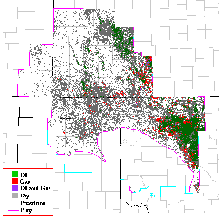
Play Map
References
Harris, S.A., 1975, Hydrocarbon accumulation in "Meramec-Osage"
(Mississippian) rocks, Sooner Trend, northwest-central Oklahoma:
American Association of Petroleum Geologists Bulletin, v. 59, p.
633-664.
Hester, T.C., Schmoker, J.W., and Sahl, H.L., 1990, Log-derived regional
source-rock characteristics of the Woodford Shale, Anadarko basin,
Oklahoma: U.S. Geological Survey Bulletin 1866-D, 64 p.
Hill, G.W., Jr., and Clark, R.H., 1980, The Anadarko basin--A regional
petroleum accumulation--A model for future exploration and development:
Shale Shaker, v. 31, no. 3, p. 36-49.
Kansas Geological Survey, Digital Petroleum Atlas
Updated July 16, 1996
Comments to webadmin@kgs.ku.edu
URL=http://www.kgs.ku.edu/DPA/frontEnd/Anadarko/LoMiss/provSum.html